geo.wikisort.org - Mountains
Mount Haku (白山, Haku-san, "White Mountain"), or Mount Hakusan (commonly referred to as simply Hakusan), is a dormant stratovolcano in Japan. It is located on the borders of Gifu and Ishikawa, on the island of Honshu. Mount Haku is thought[citation needed] to have first been active 300,000 to 400,000 years ago, with the most recent eruption occurring in 1659. Along with Mount Tate and Mount Fuji, it is one of Japan's "Three Holy Mountains" (三霊山, San-rei-zan).[2]
| Mount Haku | |
|---|---|
| 白山 | |
 Mount Haku seen from Onanjimine | |
| Highest point | |
| Elevation | 2,702.2 m (8,865 ft)[1] |
| Prominence | 1,897 m (6,224 ft)[1] |
| Listing | • List of mountains and hills of Japan by height • 100 Famous Japanese Mountains • List of volcanoes in Japan • Ultra |
| Coordinates | 36°09′18″N 136°46′17″E[1] |
| Naming | |
| English translation | White Mountain |
| Language of name | Japanese |
| Pronunciation | [hakɯ̥saɴ] |
| Geography | |
 Mount Haku Location in Japan | |
| Location | Gifu Prefecture Fukui Prefecture Ishikawa Prefecture Japan |
| Parent range | Ryōhaku Mountains |
| Topo map | Geographical Survey Institute, 25000:1 白山, 50000:1 白山 |
| Geology | |
| Age of rock | 300,000–400,000 years |
| Mountain type | Stratovolcano (active) |
| Last eruption | April to August 1659 |
| Climbing | |
| First ascent | Taichō in 717 |
Outline
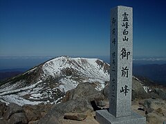
The mountain's tallest peak, Gozenga-mine (御前峰), is the one that gives the mountain its height of 2,702 m (8,865 ft). Along with Ken-ga-mine (剣ヶ峰), which is 2,677 m (8,783 ft), and Ōnanji-mine (大汝峰), which is 2,648 m (8,688 ft), the three peaks are considered "Mount Haku's Three Peaks" (白山三峰 Hakusan San-mine). Mount Bessan and Mount Sannomine are sometimes included and called "Mount Haku's Five Peaks" (白山五峰 Hakusan go-mine).
Because it is very prominent and clearly visible from the nearby coast, even after the surrounding mountains have lost their snow, Mount Haku still appears white, which is one explanation for the mountain's name, which means "white mountain." It is also the westernmost mountain in Japan that is over 2,000 m (6,562 ft) in height.
History and culture
Taichō, a mountain Shugendo monk, first climbed Mount Hakusan in 717. For hundreds of years, people have come to Haku for prayers (白山信仰 Hakusan Shinkō). A branch shrine of Shirayama Hime Shrine, which served as the supreme shrine for Kaga Province, is on the mountain. The Shirayama Hime Shrine is the main shrine (総本社, sō-honsha) of approximately 2,000 Hakusan shrines (白山神社, Hakusan jinja) in Japan. In 1980 an area of 48,000 ha was designated a UNESCO Man and the Biosphere Reserve.[3]
Nature
Mount Haku was designated as a quasi-national park in 1955. It became a national park in 1962[2] and was renamed Hakusan National Park. Because the central part of the mountain has much precipitous terrain, there are very few roads and, as a result, little human intrusion into the area. Also limiting human intrusion is the designation of the park as a Wildlife Protection Area, covering over 38,061 ha. The park stretches beyond the mountain's borders into Toyama Prefecture.[2]
Geological features
The area surrounding Mount Haku is one of the few in Japan that contains outcroppings from the Jurassic period of the Mesozoic era. Many of Japan's typical examples of dinosaur fossils were found in this area. One of the major rock outcrops is in the Kuwashima area and is known as the "Kuwashima Fossil Wall" (桑島化石壁 Kuwashima Kasekikabe).
Because the mountain is a dormant volcano, it is well known for its many onsen.
Flora
Mount Haku is known for its diverse plant life. Along the Sabō Trail, after passing the Jinnosuke Lodge, alpine plants are found, including the chocolate lily, which is Ishikawa's prefectural plant.
There are many alpine plants which have Hakusan in their name. These include Primula cuneifolia (Hakusan Kozakura), Anemone narcissiflora (Hakusan Ichige), Dactylorhiza (Hakusan Chidori), Geranium yesoemse (Hakusan Fuuro) and Rhododendron brachycarpum (Hakusan Shakunage). These plants can be found on many mountains throughout Japan, but they were first discovered and named along the older hiking trails leading to Hakusan Shrine.
| Chocolate lily (Kuro Yuri) | Primula cuneifolia (Hakusan Kozakura) | Anemone narcissiflora (Hakusan Ichige) | Dactylorhiza aristata (Hakusan Chidori) |
|---|---|---|---|
 |
 |
 |
 |
Fauna
The golden eagle, Ishikawa's prefectural bird, lives on the slopes of Mount Haku. The rock ptarmigan, Gifu's prefectural bird,[4] used to live on the slopes as well. During the Meiji period, the entire population of ptarmigan on the mountain disappeared; however, sightings of the grouse have recently been recorded by local residents.
Hiking trails
The three most used hiking trails are the Kankō Trail (観光新道 Kankō Shinmichi), the Sabō Trail (砂防新道 Sabō Shinmichi) and the Hirase Trail (平瀬道 Hirase-dō). Both the Kankō Trail and the Sabō trail originate in the city of Hakusan, Ishikawa Prefecture, but the Hirase Trail starts from the Ōshirakawa Dam (大白川ダム) in Gifu Prefecture.
Because the area is protected as a national park, very few trails have been made on the mountain. Though the trails listed above are easy enough to hike up and down in one day, other trails can take two or three days because of the uncleared trails and rough terrain.
Gallery
 Top of Gozengamine (Mount Haku) and Ōnanjimine
 Hakusan Shrine at Murodo and Gozengamine
 Volcanic crater (Midoriga-ike)
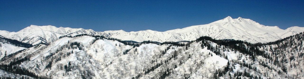
 Mount Haku in each season
 Mount Haku from Midagahara
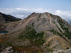 Kengamine Peak from Gozengamine Peak
 Mount Haku from east of Mount Hideri
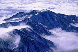 Mount Bessan from the top of Gozengamine


See also
- Hakusan National Park
- Ryōhaku Mountains
- List of volcanoes in Japan
- List of mountains in Japan
- Taichō
References
- "Japan Ultra-Prominences". Peaklist.org. Retrieved 2015-01-01.
- UNESCO Biosphere Reserve Information: Mount Hakusan. UNESCO. Accessed May 16, 2008.
- "Biosphere Reserve Information - Mount Hakusan". UNESCO. Retrieved 29 April 2011.
- A Statistical Guide to Gifu Prefecture 2007 Archived 2009-03-25 at the Wayback Machine. Gifu Prefecture. Accessed May 16, 2008.
External links
- Hakusan - Japan Meteorological Agency (in Japanese)
- "Hakusan: National catalogue of the active volcanoes in Japan" (PDF). - Japan Meteorological Agency
- Hakusan - Geological Survey of Japan
- "Hakusan". Global Volcanism Program. Smithsonian Institution. Retrieved 2021-06-24.
| Hokkaidō | |||||||||
|---|---|---|---|---|---|---|---|---|---|
| Tōhoku region Jōshinetsu region |
| ||||||||
| Kantō region | |||||||||
| Chūbu region |
| ||||||||
| Western Japan | |||||||||
| |||||||||
На других языках
[de] Haku-san
Der Haku-san (japanisch 白山) ist ein Schichtvulkan im japanischen Ryōhaku-Gebirge mit einer Höhe von 2702 m.[1] Der Haku-san ist der westlichste Zweitausender Japans. Er ist von der nahe gelegenen Küste aus sehr gut sichtbar und erscheint selbst nachdem die umliegenden Berge ihren Schnee verloren haben immer noch weiß. Daraus leitet sich vermutlich die Bezeichnung des Berges als „weißer Berg“ ab. Er ist einer der drei heiligen Berge Japans und ist zudem in den 100 berühmten japanischen Bergen (日本百名山 .mw-parser-output .Latn{font-family:"Akzidenz Grotesk","Arial","Avant Garde Gothic","Calibri","Futura","Geneva","Gill Sans","Helvetica","Lucida Grande","Lucida Sans Unicode","Lucida Grande","Stone Sans","Tahoma","Trebuchet","Univers","Verdana"}Nihon-Hyakumeizan) aufgelistet.[2] [3] Der Haku-san liegt innerhalb des Hakusan-Nationalparks auf der Grenze zwischen den Präfekturen Ishikawa im Nordwesten und Gifu im Südosten.- [en] Mount Haku
[fr] Mont Haku
Le mont Haku (白山, Haku-san?), ou Hakusan, est une des 100 montagnes célèbres du Japon et un volcan actif. Ce stratovolcan est situé à la limite des préfectures d'Ishikawa et Gifu. Les volcanologues estiment que le volcan a connu sa première activité il y a 300 000 à 400 000 ans, la plus récente éruption étant survenue en 1659. Avec le mont Tate et le mont Fuji, c'est l'une des « Trois montagnes sacrées » (三霊山, Sanreizan?) du Japon.[it] Monte Haku
Il Monte Haku (白山 Hakusan?, "Montagna Bianca"), o Monte Hakusan (comunemente abbreviato come Hakusan), è un vulcano potenzialmente attivo del Giappone. Si tratta di uno stratovulcano localizzato ai confini delle prefetture di Gifu, Fukui e Ishikawa, nell'Honshū. Nell'Olocene le eruzioni sono state di tipo freatico o freatomagmatico originatesi da diversi crateri sommitali, l'ultima delle quali è del XVII secolo.[ru] Хакусан (гора)
Хакусан, или Хаку (яп. 白山 Хаку-сан, «Белая гора») — потенциально активный стратовулкан в Японии. Наряду с Фудзиямой и Татэямой является одной из трёх священных гор Японии[2].Другой контент может иметь иную лицензию. Перед использованием материалов сайта WikiSort.org внимательно изучите правила лицензирования конкретных элементов наполнения сайта.
WikiSort.org - проект по пересортировке и дополнению контента Википедии