geo.wikisort.org - Mountains
Mt. Bessan (別山, Bessan) is located on the border of Gujō, Gifu Prefecture, and Hakusan, Ishikawa Prefecture, Japan, and rises to a height of 2,399 m (7,871 ft). There are two triangulation stations at the top of the mountain. Mount Haku can be seen from the north. Bessan Shrine (別山神社 Bessan Jinja) is a short distance from the peak. This area is part of Hakusan National Park.[1] (Note: there is also a Mt. Bessan in located in Toyama Prefecture.)
| Mount Bessan | |
|---|---|
| 別山 | |
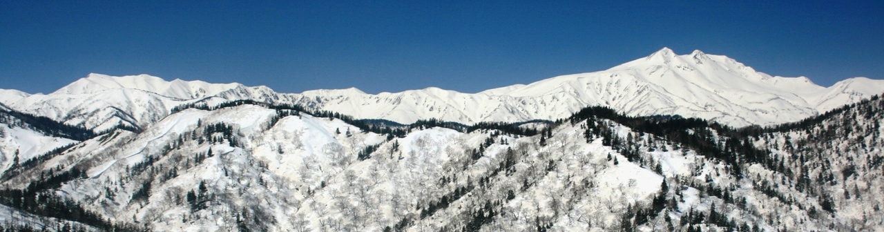
 View of Mount Bessan from Sannomine | |
| Highest point | |
| Elevation | 2,399 m (7,871 ft) |
| Coordinates | 36°06′20″N 136°45′56″E |
| Geography | |
 Mount Bessan Gujō, Gifu Prefecture Hakusan, Ishikawa Prefecture, Japan | |
| Parent range | Ryōhaku Mountains |
| Geology | |
| Mountain type | Sedimentary |
History
Mount Haku has been climbed for religious purposes for centuries. One popular hiking route from the Gifu Prefecture side of the mountains to Mount Haku's peak runs through Mount Bessan. Mount Bessan, whose name means "Separate Mountain," received its name because it is slightly separated from the south side of Mount Haku. To the south of Mount Bessan is a small flat area called the Bessan Plain (別山平 Bessan Hira) and Lake Mitarashi (御手洗池 Mitarashi Ike). Near the lake are the ruins for the Bessan Room (別山室 Bessan-ya), which was used as a rest house for those making the pilgrimage up the mountain.
Geography
Though Mount Haku, the main peak in the Ryōhaku Mountains, was created by an active stratovolcano, Mount Bessan is made up of sedimentary rock. On the southern face of the mountain is a rock wall called the Taihei Wall (太平壁 Taihei-kabe). Near the peak of the mountain is the tree line made up of Siberian Dwarf Pines. In the beginning of summer, alpine plants like anemones. A wider variety of plants can be seen at lower levels, but the surrounding area is part of Japan's snow country, so it is covered by snow for more than half of the year.
References
- Hakusan National Park Archived 2012-02-08 at the Wayback Machine. Ministry of the Environment (Japan).
See also
- Hakusan National Park
- Ryōhaku Mountains
На других языках
[de] Bessan (Berg)
Der Bessan (別山) ist ein Berg im Ryōhaku-Gebirge mit einer Höhe von 2399 m. Er befindet sich innerhalb des Hakusan-Nationalparks auf der Grenze zwischen den japanischen Präfekturen Ishikawa und Gifu.[1] Der Bessan liegt auf dem shintoistischen Pilgerweg Mino-Zenjōdō (美濃禅定道). Diese Route führt vom Nagataki-Hakusan-Schrein (長滝白山神社 .mw-parser-output .Latn{font-family:"Akzidenz Grotesk","Arial","Avant Garde Gothic","Calibri","Futura","Geneva","Gill Sans","Helvetica","Lucida Grande","Lucida Sans Unicode","Lucida Grande","Stone Sans","Tahoma","Trebuchet","Univers","Verdana"}Nagataki-Hakusan-Jinja) in Gujō in der Präfektur Gifu über den Hakusan-Chuukyo-Schrein (白山中居神社 Hakusan-Chuukyo-Jinja), an der Itoshiro-Riesenzeder, den Ruinen des Kamibato-Schreins und Mizuno-Gongen-Schreins vorbei zum Gipfel Sannomine und von dort über den Mitarai-Teich und Murodō zum Gipfel des Haku-san.[2]- [en] Mount Bessan
[fr] Mont Bessan
Le mont Bessan (別山, Bessan?), culminant à 2 399 m d'altitude, est situé à la limite de Gujō dans la préfecture de Gifu et Hakusan dans la préfecture d'Ishikawa au Japon. Il y a deux stations de triangulation au sommet de la montagne. Le mont Haku est visible depuis le nord. Le Bessan-jinja se trouve à peu de distance du sommet. Cette zone fait partie du parc national de Hakusan[2].Другой контент может иметь иную лицензию. Перед использованием материалов сайта WikiSort.org внимательно изучите правила лицензирования конкретных элементов наполнения сайта.
WikiSort.org - проект по пересортировке и дополнению контента Википедии