geo.wikisort.org - Mountains
Mount Ibuki (伊吹山, Ibuki-yama) is a 1,377-metre-high (4,518 ft) mountain, on the border of Maibara, Shiga Prefecture, and Ibigawa, Gifu Prefecture, Japan. It is one of the 100 Famous Japanese Mountains, and is also included on the lists of the 100 Kinki Mountains and the 50 Shiga Mountains. Mount Ibuki is the highest mountain in Shiga Prefecture.
| Mount Ibuki | |
|---|---|
| 伊吹山 | |
 Mount Ibuki and N700 Series Shinkansen | |
| Highest point | |
| Elevation | 1,377 m (4,518 ft) |
| Listing | 100 Famous Japanese Mountains |
| Coordinates | 35°25′04″N 136°24′22″E |
| Naming | |
| Language of name | Japanese |
| Geography | |
 Mount Ibuki Location of Mount Ibuki in Japan | |
| Location | Ibigawa, Gifu Prefecture Maibara, Shiga Prefecture Japan |
| Geology | |
| Mountain type | Limestone |
Outline
Mount Ibuki is the highest peak in the Ibuki Mountains, which stretch from north to south along the border of Shiga Prefecture and Gifu Prefecture. Located at the southern end of the mountain chain with the Suzuka Mountains not too far to the south, a small plain at the foot of this mountain, Sekigahara, became one of the most important strategic points throughout Japanese history.
Nature
Since ancient times, Mount Ibuki has also been known for its rich variety of wild plants and animals, as well as for its beautiful shape.
Climate
Mount Ibuki has a humid continental climate (Köppen climate classification Dfb) with mild summers and cold winters. On February 14 1927, 230 centimetres (90.6 in) of snow fell on Mount Ibuki, [1] which is one of the highest 24 hour totals on record.
| Climate data for Mount Ibuki (1961−1990 normals, extremes 1919−2001) | |||||||||||||
|---|---|---|---|---|---|---|---|---|---|---|---|---|---|
| Month | Jan | Feb | Mar | Apr | May | Jun | Jul | Aug | Sep | Oct | Nov | Dec | Year |
| Record high °C (°F) | 9.9 (49.8) |
10.8 (51.4) |
14.6 (58.3) |
22.1 (71.8) |
23.5 (74.3) |
25.4 (77.7) |
27.6 (81.7) |
29.2 (84.6) |
28.8 (83.8) |
21.4 (70.5) |
18.3 (64.9) |
13.8 (56.8) |
29.2 (84.6) |
| Average high °C (°F) | −3.4 (25.9) |
−2.9 (26.8) |
0.6 (33.1) |
8.3 (46.9) |
13.2 (55.8) |
16.2 (61.2) |
19.8 (67.6) |
20.9 (69.6) |
17.1 (62.8) |
11.9 (53.4) |
6.2 (43.2) |
−0.3 (31.5) |
9.0 (48.2) |
| Daily mean °C (°F) | −5.7 (21.7) |
−5.4 (22.3) |
−2.4 (27.7) |
4.6 (40.3) |
9.5 (49.1) |
13.3 (55.9) |
17.2 (63.0) |
18.0 (64.4) |
14.3 (57.7) |
8.5 (47.3) |
3.1 (37.6) |
−2.6 (27.3) |
6.0 (42.9) |
| Average low °C (°F) | −8.0 (17.6) |
−7.9 (17.8) |
−5.3 (22.5) |
1.3 (34.3) |
6.2 (43.2) |
10.8 (51.4) |
15.0 (59.0) |
15.9 (60.6) |
12.1 (53.8) |
5.9 (42.6) |
0.4 (32.7) |
−4.9 (23.2) |
3.5 (38.2) |
| Record low °C (°F) | −16.3 (2.7) |
−16.5 (2.3) |
−15.9 (3.4) |
−10.0 (14.0) |
−5.6 (21.9) |
0.3 (32.5) |
6.5 (43.7) |
7.6 (45.7) |
3.2 (37.8) |
−3.6 (25.5) |
−9.9 (14.2) |
−14.7 (5.5) |
−16.5 (2.3) |
| Average precipitation mm (inches) | — | — | — | 141.1 (5.56) |
169.2 (6.66) |
292.1 (11.50) |
331.2 (13.04) |
212.9 (8.38) |
246.8 (9.72) |
138.6 (5.46) |
86.0 (3.39) |
— | — |
| Average snowfall cm (inches) | 431 (170) |
493 (194) |
469 (185) |
338 (133) |
62 (24) |
0 (0) |
0 (0) |
0 (0) |
0 (0) |
trace | 21 (8.3) |
132 (52) |
1,946 (766.3) |
| Average relative humidity (%) | 90 | 88 | 84 | 80 | 80 | 89 | 94 | 93 | 91 | 83 | 85 | 89 | 87 |
| Mean monthly sunshine hours | 66.3 | 77.3 | 129.4 | 146.6 | 172.5 | 112.3 | 99.7 | 121.6 | 98.3 | 136.2 | 106.5 | 78.1 | 1,344.8 |
| Source 1: NOAA (1961-1990)[2] | |||||||||||||
| Source 2: JMA[3] | |||||||||||||
Route
There are two ways to ascend Mount Ibuki. The easiest way is to use the Ibuki Driveway. The summit is a 10-minute walk from the parking lot. There is also a bus going from Sekigahara Station up to the parking lot in the summer months. The alternative method is to simply climb the mountain from its base. Many climbers climb from the Ibuki-Tozanguchi bus stop, which is 10 minutes by bus from Omi-Nagaoka Station on the Tōkaidō Main Line. Until 2011 there was a gondola going to the ski resort Sangome about halfway on the mountain slope. Both have been shut down since then and all the lifts have been removed.
Access
- Ibuki-Tozanguchi Bus Stop of Kokoku Bus from Ōmi-Nagaoka Station or Nagahama Station
Gallery
 From Mount Ikeda
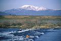 From Ibi River
 From Maibara
 From Mount Ryōzen
 From Pond Mishima
 From Kohoku Mizudori station
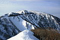 From Shizumagahara


See also
- Japanese battlecruiser Ibuki
- Japanese cruiser Ibuki (1943)
- The 100 Views of Nature in Kansai
References
- "Weather Records of Mt. Ibuki". Japan Meteorological Agency. Retrieved 2010-03-03. (in Japanese)
- "Ibukiyama Climate Normals 1961-1990". National Oceanic and Atmospheric Administration. Retrieved January 6, 2013.
- 観測史上1~10位の値(年間を通じての値). JMA. Retrieved February 26, 2022.
External links
| Hokkaidō | |||||||||
|---|---|---|---|---|---|---|---|---|---|
| Tōhoku region Jōshinetsu region |
| ||||||||
| Kantō region | |||||||||
| Chūbu region |
| ||||||||
| Western Japan | |||||||||
| |||||||||
На других языках
- [en] Mount Ibuki
[fr] Mont Ibuki
Le mont Ibuki (伊吹山, Ibuki-yama?) est une montagne du Japon située sur l'île de Honshū, dans la préfecture de Shiga, à proximité de la frontière avec celle de Gifu. Elle fait partie des 100 montagnes célèbres du Japon.[ru] Ибуки (гора)
Ибуки — гора в Японии.Другой контент может иметь иную лицензию. Перед использованием материалов сайта WikiSort.org внимательно изучите правила лицензирования конкретных элементов наполнения сайта.
WikiSort.org - проект по пересортировке и дополнению контента Википедии