geo.wikisort.org - Mountains
Southern Yatsugatake Volcanic Group (南八ヶ岳, Minami-Yatsugatake), also known as just Yatsugatake is a volcanic group of inactive volcanoes located on the border of Nagano Prefecture and Yamanashi Prefecture on Honshū in Japan.
| Southern Yatsugatake Volcanic Group | |
|---|---|
 Yatsugatake from Mount Gongen (August 2010) | |
| Highest point | |
| Peak | Mount Aka |
| Elevation | 2,899 m (9,511 ft) |
| Coordinates | 35°58′15″N 138°22′12″E |
| Naming | |
| Etymology | Southern mountains with eight peaks |
| Native name | |
| Geography | |
 Southern Yatsugatake Volcanic Group | |
| Country | Japan |
| Prefectures | Nagano Prefecture and Yamanashi Prefecture |
| Region | Chūbu |
| Districts | Minamisaku and Suwa |
| Municipalities | Hara, Fujimi, Chino, Hokuto and Minamimaki |
| Parent range | Yatsugatake Mountains |
| Borders on | Northern Yatsugatake Volcanic Group |
| Biome | Alpine climate |
| Geology | |
| Orogeny | Island arc |
| Age of rock | Quaternary |
| Type of rock | Volcanic |

Description
The Southern Yatsugatake Volcanic Group is part of the Yatsugatake Mountains. The southern group is defined as the mountains south of the Natsuzawa Pass. The highest peak of the mountains is Mount Aka and the elevation is 2,899 metres.
The southern Yatugatake mountains are steep and have alpine characteristics. The mountains of the Northern Yatsugatake Volcanic Group are gentler and lower.
This volcanic group is listed among the 100 famous mountains in Japan. There the mountains are listed as Yatsugatake. Mount Tateshina is also part of the Yatsugatake mountains, but is listed separately.
These mountains are part of the Yatsugatake-Chūshin Kōgen Quasi-National Park.[1]
Geology
The volcanoes are stratovolcanoes that are 1 million to 200,000 years old. The rock is mainly basalt and andesite.[2]
Climate
| Climate data for Nobeyama Station, 1991–2020 normals, extremes 1978–present | |||||||||||||
|---|---|---|---|---|---|---|---|---|---|---|---|---|---|
| Month | Jan | Feb | Mar | Apr | May | Jun | Jul | Aug | Sep | Oct | Nov | Dec | Year |
| Record high °C (°F) | 11.9 (53.4) |
15.6 (60.1) |
20.1 (68.2) |
24.9 (76.8) |
26.5 (79.7) |
28.6 (83.5) |
30.7 (87.3) |
31.0 (87.8) |
29.1 (84.4) |
24.9 (76.8) |
19.7 (67.5) |
16.9 (62.4) |
31.0 (87.8) |
| Average high °C (°F) | 0.1 (32.2) |
1.1 (34.0) |
5.4 (41.7) |
12.1 (53.8) |
17.2 (63.0) |
19.9 (67.8) |
23.7 (74.7) |
24.7 (76.5) |
20.3 (68.5) |
14.7 (58.5) |
9.6 (49.3) |
3.5 (38.3) |
12.7 (54.9) |
| Daily mean °C (°F) | −5.3 (22.5) |
−4.5 (23.9) |
−0.3 (31.5) |
5.8 (42.4) |
11.0 (51.8) |
14.8 (58.6) |
18.9 (66.0) |
19.5 (67.1) |
15.5 (59.9) |
9.3 (48.7) |
3.8 (38.8) |
−1.9 (28.6) |
7.2 (45.0) |
| Average low °C (°F) | −12.2 (10.0) |
−11.4 (11.5) |
−6.4 (20.5) |
−0.6 (30.9) |
4.9 (40.8) |
10.2 (50.4) |
15.0 (59.0) |
15.5 (59.9) |
11.4 (52.5) |
4.4 (39.9) |
−1.8 (28.8) |
−7.9 (17.8) |
1.8 (35.2) |
| Record low °C (°F) | −25.1 (−13.2) |
−26.0 (−14.8) |
−25.3 (−13.5) |
−18.7 (−1.7) |
−6.6 (20.1) |
−1.4 (29.5) |
4.8 (40.6) |
4.2 (39.6) |
−2.2 (28.0) |
−8.9 (16.0) |
−14.1 (6.6) |
−23.1 (−9.6) |
−26.0 (−14.8) |
| Average precipitation mm (inches) | 46.6 (1.83) |
49.8 (1.96) |
93.4 (3.68) |
100.6 (3.96) |
124.9 (4.92) |
172.6 (6.80) |
205.6 (8.09) |
166.8 (6.57) |
204.1 (8.04) |
164.6 (6.48) |
62.4 (2.46) |
41.0 (1.61) |
1,432.4 (56.39) |
| Average precipitation days (≥ 1.0 mm) | 6.1 | 6.1 | 9.7 | 9.8 | 10.9 | 13.7 | 15.1 | 13.0 | 11.9 | 10.0 | 7.0 | 5.8 | 119.4 |
| Mean monthly sunshine hours | 175.7 | 167.1 | 179.8 | 188.3 | 186.0 | 127.7 | 142.2 | 160.1 | 124.1 | 140.2 | 167.9 | 175.5 | 1,933.7 |
| Source 1: JMA[3] | |||||||||||||
| Source 2: JMA[4] | |||||||||||||
List of peaks
The following peaks make up the Southern Yatsugatake Volcanic Group:[2][5]
| Name | Height |
|---|---|
| Mount Aka (赤岳, Aka-dake) | 2,899.2 metres (9,511.8 ft) |
| Mount Yoko (横岳, Yoko-dake) | 2,829 metres (9,281 ft) |
| Mount Amida (阿弥陀岳, Amida-dake) | 2,805 metres (9,203 ft) |
| Mount Iō (硫黄岳, Iō-dake) | 2,760 metres (9,060 ft) |
| Mount Gongen (権現岳, Gongen-dake) | 2,715 metres (8,907 ft) |
| Mount Amigasa (編笠山, Amigasa-yama) | 2,523.7 metres (8,279.9 ft) |
| Mount Nishi (西岳, Nishi-dake) | 2,398 metres (7,867 ft) |
| Utsukushimori (美し森, Utsukushi-mori) | 1,542.4 metres (5,060.4 ft) |
Gallery
 Mount Aka, the highest peak of the Yatsugatake mountains
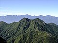 Mount Gongen, from Mount Aka
 Mount Amida, Mount Iō, Mount Yoko and Mount Aka from Mount Gongen
 Mount Amida, Mount Iō, Mount Yoko, Mount Aka and Mount Gongen from Mount Amigasa


See also
- List of mountains in Japan
- List of volcanoes in Japan
References
- 八ヶ岳中信高原国定公園. Japan Integrated Biodiversity Information System (in Japanese). Ministry of the Environment, Government of Japan. Archived from the original on 2008-05-12. Retrieved 2008-09-05.
- "YATSU-GA-TAKE". Quaternary Volcanoes of Japan. Geological Survey of Japan, AIST. 2006. Retrieved 2008-08-19.
- 観測史上1~10位の値(年間を通じての値). JMA. Retrieved February 16, 2022.
- 気象庁 / 平年値(年・月ごとの値). JMA. Retrieved February 16, 2022.
- Hunt, Paul (1988). "14. Yatsu-ga-take". Hiking in Japan: An Adventurer's Guide to the Mountain Trails (First ed.). Tokyo: Kondansha International. pp. 111–115. ISBN 0-87011-893-5.
External links
See also
- Yatsugatake-Chūshin Kōgen Quasi-National Park
- Yatsugatake Mountains - Northern Yatsugatake Volcanic Group
- List of mountains in Japan
| Hokkaidō | |||||||||
|---|---|---|---|---|---|---|---|---|---|
| Tōhoku region Jōshinetsu region |
| ||||||||
| Kantō region | |||||||||
| Chūbu region |
| ||||||||
| Western Japan | |||||||||
| |||||||||
На других языках
[de] Yatsugatake
Yatsugatake (jap. 八ヶ岳) ist ein vulkanreiches Bergmassiv in Japan, das sich über die Präfekturen Nagano und Yamanashi erstreckt.- [en] Southern Yatsugatake Volcanic Group
[fr] Groupe volcanique méridional de Yatsugatake
Le groupe volcanique méridional de Yatsugatake (南八ヶ岳, Minami-Yatsugatake?), aussi appelé juste Yatsugatake, est un groupe volcanique de volcans inactifs situé à la limite des préfectures de Nagano et Yamanashi dans le Honshū au Japon.Другой контент может иметь иную лицензию. Перед использованием материалов сайта WikiSort.org внимательно изучите правила лицензирования конкретных элементов наполнения сайта.
WikiSort.org - проект по пересортировке и дополнению контента Википедии