geo.wikisort.org - Mountains
The Hida Mountains (飛騨山脈, Hida Sanmyaku)[1][circular reference], or Northern Alps (北アルプス, Kita Arupusu), is a Japanese mountain range which stretches through Nagano, Toyama and Gifu prefectures. A small portion of the mountains also reach into Niigata Prefecture. William Gowland coined the phrase "Japanese Alps" during his time in Japan, but he was only referring to the Hida Mountains when he used that name. The Kiso and Akaishi mountains received the name in the ensuing years.
| Hida Mountains (飛騨山脈) | |
|---|---|
| Northern Alps (北アルプス) | |
A view from Mount Kashimayari | |
| Highest point | |
| Peak | Mount Hotaka, Kiso District, Nagano Prefecture |
| Elevation | 3,190 m (10,470 ft) |
| Dimensions | |
| Length | 105 km (65 mi) |
| Width | 25 km (16 mi) |
| Geography | |
| Country | Japan |
| Prefectures | Niigata, Toyama, Nagano and Gifu |

Geography
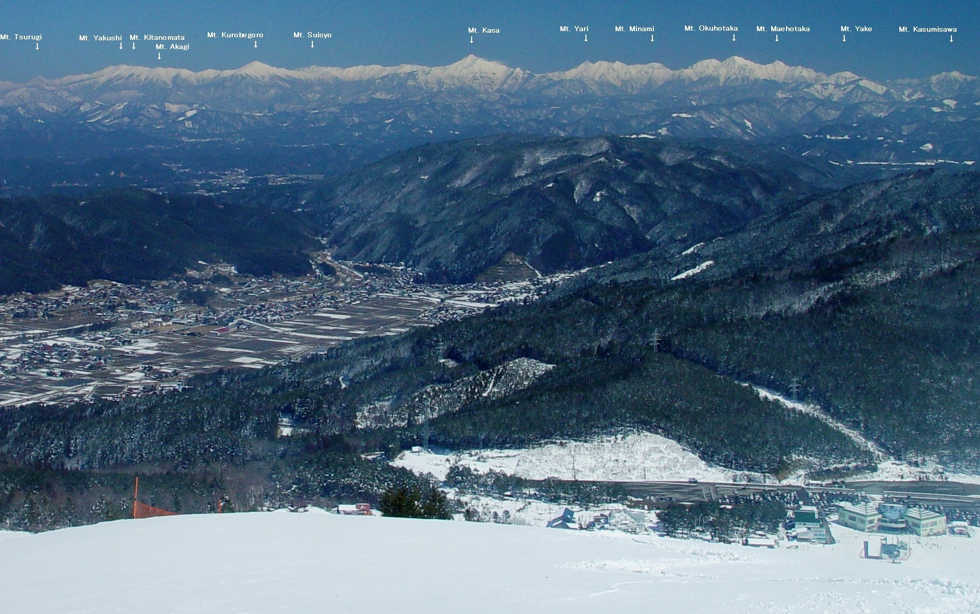
The layout of the Hida Mountains forms a large Y-shape. The southern peaks are the lower portion of the Y-shape, with the northern peaks forming two parallel bands separated by a deep V-shaped valley. It is one of the steepest V-shaped valleys in Japan. The Kurobe Dam, Japan's largest dam, is an arch dam located in the Kurobe Valley in the central area of the mountains. The western arm of mountains, also known as the Tateyama Peaks (立山連峰 Tateyama Renpō), are dominated by Mount Tsurugi and Mount Tate. The eastern arm, known as the Ushiro Tateyama Peaks (後立山連峰 Ushiro Tateyama Renpō), are dominated by Mount Shirouma and Mount Kashimayari.
Glaciers
Although it was originally thought that no glaciers existed in East Asia south of Kamchatka, recent research has shown that three small glaciers still survive in Mount Tsurugi and Mount Tate owing to the extremely wet climate of the Hokuriku region allowing for very heavy snowfalls on the high peaks.[2]
Major peaks
- Mount Shirouma, 2,932 m (9,619 ft)
- Mount Kashimayari, 2,889 m (9,478 ft)
- Mount Tate, 3,015 m (9,892 ft)
- Mount Tsubakuro, 2,763 m (9,065 ft)
- Mount Tsurugi, 2,999 m (9,839 ft)
- Mount Noguchigoro, 2,924 m (9,593 ft)
- Mount Yari, 3,180 m (10,433 ft)
- Mount Hotaka, 3,190 m (10,466 ft)
- Mount Norikura, 3,026 m (9,928 ft)
Gallery
 South half part of Hida Mountains
 Mount Tateyama
 Mount Yari and Mount Hotaka
 Mount Nishihotaka from Nishihotaka-guchi Station
 South half part seen from Mount Kurai


See also
- Japanese Alps
- Kiso Mountains (Central Alps)
- Akaishi Mountains (Southern Alps)
- List of mountains in Japan
- 100 Famous Japanese Mountains
- Chūbu-Sangaku National Park
References
- ja:飛騨山脈
- "First glaciers in Japan recognized". 6 April 2012.
External links
- North Alps Broad Band Network Archived 2018-04-19 at the Wayback Machine (in English, Japanese, and Korean)
- Northern Alps Lodging Cooperative (in Japanese)
- Northern Alps Information for Gifu Prefecture (in Japanese)
Authority control | |
|---|---|
| General |
|
| National libraries | |
This Gifu Prefecture location article is a stub. You can help Wikipedia by expanding it. |
This Nagano Prefecture location article is a stub. You can help Wikipedia by expanding it. |
This Toyama location article is a stub. You can help Wikipedia by expanding it. |
This Niigata Prefecture location article is a stub. You can help Wikipedia by expanding it. |
На других языках
[de] Hida-Gebirge
Das Hida-Gebirge (jap. 飛騨山脈, Hida-sanmyaku) auch japanische „Nordalpen“ (北アルプス, Kita Arupusu für engl. Alps) genannt, ist ein Gebirgszug in Japan, der sich über die Präfekturen Nagano, Toyama und Gifu erstreckt. Zusammen mit dem Kiso-Gebirge (Zentralalpen) und dem Akaishi-Gebirge (Südalpen) bildet es die Japanischen Alpen. Über das Gebirge erstreckt sich der Chūbu-Sangaku-Nationalpark.- [en] Hida Mountains
[es] Montañas Hida
Las montañas Hida (飛騨山脈, Hida Sanmyaku?), o Alpes del Norte (北アルプス, Kita Arupusu?), conforman una cadena montañosa japonesa que bordea las prefecturas de Nagano, Toyama y Gifu.[fr] Monts Hida
Les monts Hida (飛騨山脈, Hida sanmyaku?) ou Alpes du Nord (北アルプス, Kita arupusu?) sont un massif montagneux du Japon. Il s'étend à travers les préfectures de Nagano, Toyama, Gifu et Niigata.[it] Monti Hida
I monti Hida (飛騨山脈 Hida Sanmyaku?), o Alpi Settentrionali (北アルプス Kita Arupusu?), sono una catena montuosa giapponese, parte delle cosiddette Alpi giapponesi, che si estende attraverso le prefetture di Nagano, Toyama e Gifu. Una piccola porzione dei monti arriva anche nella prefettura di Niigata. William Gowland coniò l'espressione "Alpi giapponesi" durante il suo soggiorno in Giappone, ma quando usò quel nome si stava riferendo solo ai Monti Hida, che sono la porzione settentrionale. Gli altri due segmenti della catena, i monti Kiso (Alpi Centrali) e Akaishi (Alpi Meridionali), ricevettero il nome negli anni successivi.Другой контент может иметь иную лицензию. Перед использованием материалов сайта WikiSort.org внимательно изучите правила лицензирования конкретных элементов наполнения сайта.
WikiSort.org - проект по пересортировке и дополнению контента Википедии