geo.wikisort.org - Mountains
Mount Tsurugi (剣山, Tsurugi-san), meaning sword, is a 1,954.7-metre-high (6,413.1 ft) mountain on the border of Miyoshi, Mima and Naka in Tokushima Prefecture, Japan. This mountain is one of the 100 Famous Japanese Mountains.
| Mount Tsurugi | |
|---|---|
| 剣山 | |
 | |
| Highest point | |
| Elevation | 1,954.7 m (6,413 ft)[1] |
| Prominence | 1,540 m (5,050 ft)[1] |
| Listing | Ultra |
| Coordinates | 33°51′13″N 134°05′39″E |
| Naming | |
| Language of name | Japanese |
| Geography | |
 Mount Tsurugi Japan | |
| Location | On the border of Miyoshi, Mima and Naka, Tokushima, Japan |
| Parent range | Shikoku Mountains |
| Geology | |
| Mountain type | Upheaval Peneplain |
Outline
Mount Tsurugi is the second highest mountain on the island of Shikoku, and also the second highest mountain west of Mount Haku, which is on the border of Ishikawa and Gifu prefectures in central Japan.
Mount Tsurugi is an important object of worship in this region and one of the centers of Shugendō, a sect of mixture of Shintoism and Buddhism. On the top of the mountain, there is a small shrine called ‘Tsurugi Jinja’.
The area around Mount Tsurugi is a major part of Tsurugi Quasi-National Park.
Climate
Mount Tsurugi has an altitude-affected humid continental climate (Köppen climate classification Dfb) with mild summers and cold winters.
| Climate data for Mount Tsurugi (1961−1990 normals, extremes 1944−2000) | |||||||||||||
|---|---|---|---|---|---|---|---|---|---|---|---|---|---|
| Month | Jan | Feb | Mar | Apr | May | Jun | Jul | Aug | Sep | Oct | Nov | Dec | Year |
| Record high °C (°F) | 8.1 (46.6) |
10.7 (51.3) |
13.9 (57.0) |
19.9 (67.8) |
20.8 (69.4) |
22.8 (73.0) |
26.6 (79.9) |
24.8 (76.6) |
22.7 (72.9) |
19.1 (66.4) |
16.0 (60.8) |
12.6 (54.7) |
26.6 (79.9) |
| Average high °C (°F) | −4.1 (24.6) |
−3.1 (26.4) |
0.5 (32.9) |
7.1 (44.8) |
11.4 (52.5) |
14.4 (57.9) |
17.9 (64.2) |
18.2 (64.8) |
15.2 (59.4) |
9.8 (49.6) |
5.0 (41.0) |
−0.8 (30.6) |
7.6 (45.7) |
| Daily mean °C (°F) | −7.3 (18.9) |
−6.6 (20.1) |
−3.3 (26.1) |
3.3 (37.9) |
7.7 (45.9) |
11.3 (52.3) |
15.1 (59.2) |
15.3 (59.5) |
12.1 (53.8) |
6.3 (43.3) |
1.3 (34.3) |
−4.3 (24.3) |
4.2 (39.6) |
| Average low °C (°F) | −10.3 (13.5) |
−9.9 (14.2) |
−6.9 (19.6) |
−0.3 (31.5) |
4.3 (39.7) |
8.6 (47.5) |
12.9 (55.2) |
13.2 (55.8) |
9.6 (49.3) |
3.3 (37.9) |
−1.9 (28.6) |
−7.3 (18.9) |
1.3 (34.3) |
| Record low °C (°F) | −19.2 (−2.6) |
−23.5 (−10.3) |
−19.1 (−2.4) |
−16.9 (1.6) |
−7.0 (19.4) |
−0.7 (30.7) |
4.3 (39.7) |
5.8 (42.4) |
−1.2 (29.8) |
−7.6 (18.3) |
−13.5 (7.7) |
−18.1 (−0.6) |
−23.5 (−10.3) |
| Average precipitation mm (inches) | 126.4 (4.98) |
146.9 (5.78) |
207.6 (8.17) |
210.9 (8.30) |
277.7 (10.93) |
463.3 (18.24) |
435.0 (17.13) |
517.0 (20.35) |
533.1 (20.99) |
223.7 (8.81) |
153.0 (6.02) |
90.8 (3.57) |
3,385.4 (133.27) |
| Average snowfall cm (inches) | 87 (34) |
89 (35) |
72 (28) |
17 (6.7) |
0 (0) |
0 (0) |
0 (0) |
0 (0) |
0 (0) |
1 (0.4) |
11 (4.3) |
48 (19) |
325 (127.4) |
| Average precipitation days (≥ 1.0 mm) | 16.9 | 15.1 | 16.6 | 13.1 | 12.7 | 15.6 | 16.3 | 15.5 | 15.6 | 11.8 | 10.1 | 13.1 | 172.4 |
| Average snowy days (≥ 1 cm) | 9.0 | 8.6 | 6.6 | 1.3 | 0 | 0 | 0 | 0 | 0 | 0.2 | 1.5 | 5.5 | 32.7 |
| Average relative humidity (%) | 81 | 81 | 80 | 76 | 75 | 85 | 90 | 91 | 89 | 80 | 76 | 78 | 82 |
| Mean monthly sunshine hours | 112.1 | 110.7 | 145.7 | 157.6 | 168.7 | 112.3 | 110.5 | 113.8 | 99.0 | 128.5 | 123.5 | 122.6 | 1,505 |
| Source 1: NOAA (1961-1990) [2] | |||||||||||||
| Source 2: JMA[3] | |||||||||||||
Access
- The main trailhead, along with parking lots, shops and restaurants, is located at Minokoshi, at the intersection of national routes 438 and 439. From Minokoshi, climbers may also ride a chairlift to a higher point on the trail.
- Trails link the summit of Mount Tsurugi to neighboring mountains. Tsurugi can be reached from the east via Ichinomori, while an extensive network of trails to the west allows access from mountains such as Jirogyu, Miune, and Tengu-zuka.
 Tsurugi Jinja (Tsurugi Shrine) on the top of Mount Tsurugi
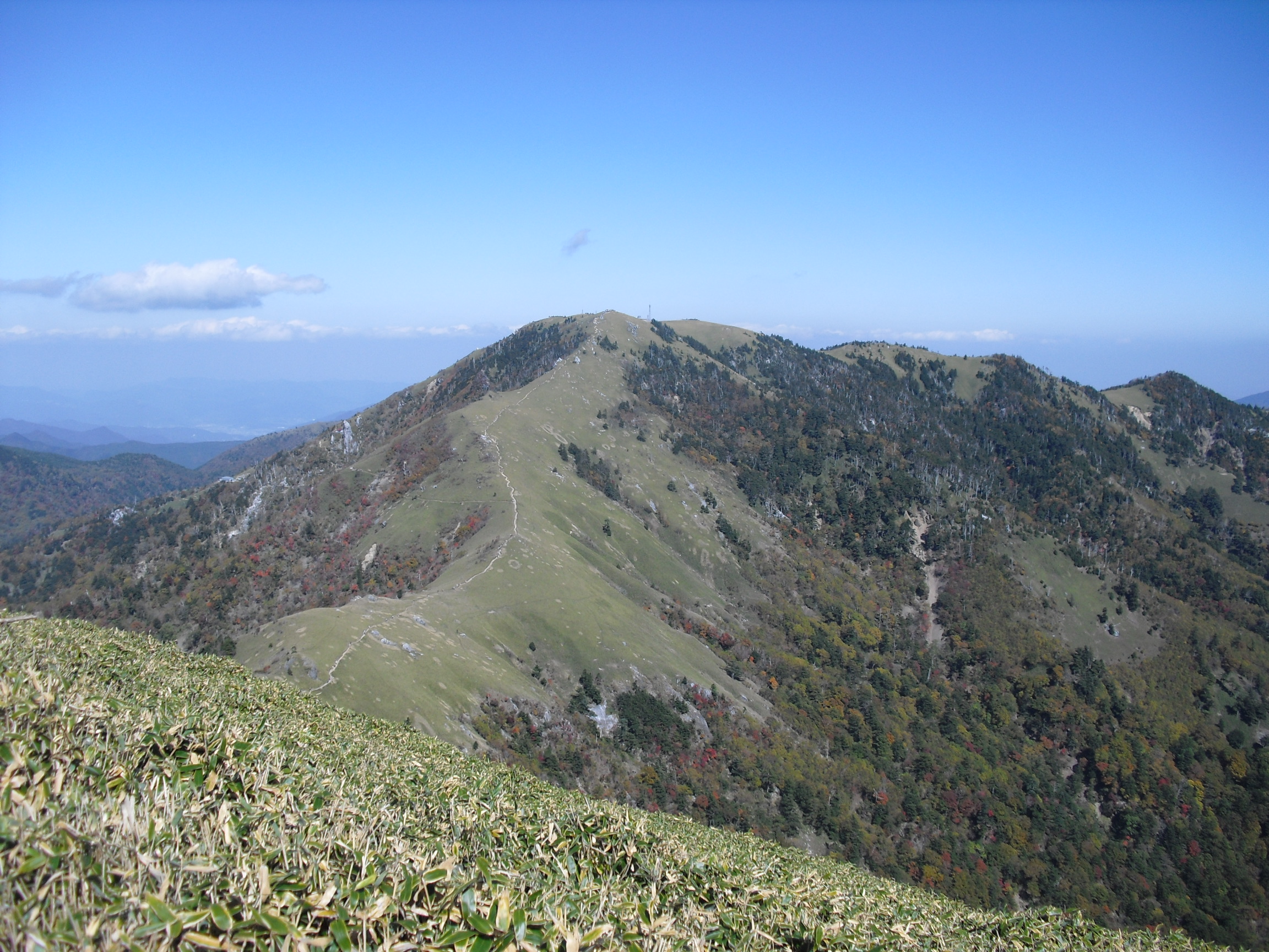
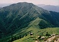 Mount Jirogyu from the top of Mount Tsurugi
 A view of the middle of Mount Tsurugi
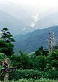 Another view of the middle of Mount Tsurugi


See also
- List of Ultras of Japan
- Tsurugisan (train), a train service named after Mount Tsurugi in Tokushima
References
- "Japan Ultra-Prominences". Peaklist.org. Retrieved 2013-03-23.
- "Tsurugisan Climate Normals 1961-1990". National Oceanic and Atmospheric Administration. Retrieved January 7, 2013.
- 観測史上1~10位の値(年間を通じての値). JMA. Retrieved February 18, 2022.
External links
- the Geographical Survey Institute in Japan
- Tsurugi Quasi-National Park
- ‘Ishizuchi Shinko Tsurugisan’
- "Tsurugi-san, Japan" on Peakbagger
| Hokkaidō | |||||||||
|---|---|---|---|---|---|---|---|---|---|
| Tōhoku region Jōshinetsu region |
| ||||||||
| Kantō region | |||||||||
| Chūbu region |
| ||||||||
| Western Japan | |||||||||
| |||||||||
Authority control | |
|---|---|
| General | |
| National libraries | |
На других языках
- [en] Mount Tsurugi (Tokushima)
[fr] Mont Tsurugi (Tokushima)
Le mont Tsurugi (剣山, Tsurugi-san?), nom qui signifie « épée », est une des 100 montagnes célèbres du Japon. Cette montagne de 1 955 m d'altitude se trouve à la limite de Miyoshi, Mima et Naka dans la préfecture de Tokushima au Japon.Другой контент может иметь иную лицензию. Перед использованием материалов сайта WikiSort.org внимательно изучите правила лицензирования конкретных элементов наполнения сайта.
WikiSort.org - проект по пересортировке и дополнению контента Википедии