geo.wikisort.org - Mountains
Mount Utsugi (空木岳, Utsugi-dake) is a mountain located on the boundary of Okuwa, Iijima and Miyada, Nagano Prefecture, in the Chūbu region of Japan. It is 2,864 m (9,396 ft) tall and part of the Kiso Mountains. It is also included on the list of "100 Famous Japanese Mountains."
This article does not cite any sources. (August 2010) |
| Mount Utsugi | |
|---|---|
| 空木岳 | |
 Mount Utsugi from Mount Akanigi | |
| Highest point | |
| Elevation | 2,864 m (9,396 ft) |
| Coordinates | 35°43′08″N 137°49′01″E |
| Geography | |
| Location | Kiso District and Kamiina District, Nagano Prefecture, Japan |
| Parent range | Kiso Mountains |
Hiking
The landscape of Mt. Utsugi includes large granite boulders surrounded by lush greenery. Due to its distance and elevation gain it is usually completed as an overnight hike. The trail begins in the town of Komagane which is also popular for its onsen and the Komagatake Ropeway.
Gallery
 The summit of Mount Utsugi.
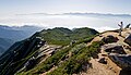 The view from the summit.


External links
Wikimedia Commons has media related to Mount Utsugi.
https://www.hikemasterjapan.com/utsugi
| Hokkaidō | |||||||||
|---|---|---|---|---|---|---|---|---|---|
| Tōhoku region Jōshinetsu region |
| ||||||||
| Kantō region | |||||||||
| Chūbu region |
| ||||||||
| Western Japan | |||||||||
| |||||||||
На других языках
- [en] Mount Utsugi
[fr] Mont Utsugi
Le mont Utsugi (空木岳, Utsugi-dake?) est une 100 montagnes célèbres du Japon. Située à la limite d'Ōkuwa, Iijima et Miyada dans la préfecture de Nagano, région du Chūbu au Japon, elle culmine à 2 864 m et fait partie des monts Kiso.Текст в блоке "Читать" взят с сайта "Википедия" и доступен по лицензии Creative Commons Attribution-ShareAlike; в отдельных случаях могут действовать дополнительные условия.
Другой контент может иметь иную лицензию. Перед использованием материалов сайта WikiSort.org внимательно изучите правила лицензирования конкретных элементов наполнения сайта.
Другой контент может иметь иную лицензию. Перед использованием материалов сайта WikiSort.org внимательно изучите правила лицензирования конкретных элементов наполнения сайта.
2019-2026
WikiSort.org - проект по пересортировке и дополнению контента Википедии
WikiSort.org - проект по пересортировке и дополнению контента Википедии