geo.wikisort.org - Mountains
Mount Tanzawa (丹沢山, Tanzawa-san, -yama) is a mountain of the Tanzawa Mountains, with an elevation of 1,567.1 metres (5,141 ft). Its summit marks the border between Sagamihara, Kiyokawa in Aikō District, and Yamakita in Ashigarakami District.
| Mount Tanzawa | |
|---|---|
| 丹沢山 | |
 View from Mount Fudō | |
| Highest point | |
| Elevation | 1,567.1 m (5,141 ft) |
| Prominence | 117 m (384 ft) |
| Parent peak | Mount Hiru |
| Listing | List of mountains and hills of Japan by height |
| Coordinates | 35°28′27″N 139°9′46″E |
| Geography | |
 Mount Tanzawa Kanagawa Prefecture, Japan | |
| Parent range | Tanzawa Mountains |
| Topo map | Geographical Survey Institute 25000:1 大山 50000:1 東京山 |
Gallery
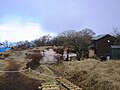 The top of Mount Tanzawa
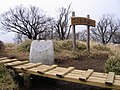 The top of Mount Tanzawa
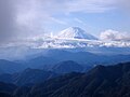 Mount Fuji from Mount Tanzawa
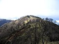 Mount Tanzawa from south
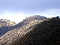 Mount Tanzawa from Mount Tō
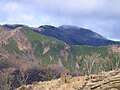 Mount Tanzawa from Mount Sannotō
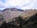 Mount Hiru, Mount Fudō and Mount Tanzawa from Mount Tō


References
Wikimedia Commons has media related to Mount Tanzawa.
| Hokkaidō | |||||||||
|---|---|---|---|---|---|---|---|---|---|
| Tōhoku region Jōshinetsu region |
| ||||||||
| Kantō region | |||||||||
| Chūbu region |
| ||||||||
| Western Japan | |||||||||
| |||||||||
This Kanagawa Prefecture location article is a stub. You can help Wikipedia by expanding it. |
На других языках
- [en] Mount Tanzawa
[fr] Mont Tanzawa
Le mont Tanzawa (丹沢山, Tanzawa-san, -yama?) est une des 100 montagnes célèbres du Japon située dans les monts Tanzawa. Culminant à 1 567 m d'altitude, son sommet marque la limite entre Sagamihara, Kiyokawa dans le district d'Aikō et Yamakita dans le district d'Ashigarakami, tous deux dans la préfecture de Kanagawa.Текст в блоке "Читать" взят с сайта "Википедия" и доступен по лицензии Creative Commons Attribution-ShareAlike; в отдельных случаях могут действовать дополнительные условия.
Другой контент может иметь иную лицензию. Перед использованием материалов сайта WikiSort.org внимательно изучите правила лицензирования конкретных элементов наполнения сайта.
Другой контент может иметь иную лицензию. Перед использованием материалов сайта WikiSort.org внимательно изучите правила лицензирования конкретных элементов наполнения сайта.
2019-2026
WikiSort.org - проект по пересортировке и дополнению контента Википедии
WikiSort.org - проект по пересортировке и дополнению контента Википедии