geo.wikisort.org - Mountains
Mount Nantai (男体山, Nantai-san, lit. 'male-body mountain',[2] also called Mount Futara (二荒山, Futāra-san)[2]) is a stratovolcano in the Nikkō National Park in Tochigi Prefecture, in central Honshū, the main island of Japan. The mountain is 2,486 metres (8,156 ft) high.[1] A prominent landmark, it can be seen on clear days from as far as Saitama, a city 100 km (62 mi) away.
This article may be expanded with text translated from the corresponding article in Japanese. (March 2022) Click [show] for important translation instructions.
|
| Mount Nantai | |
|---|---|
| 男体山 | |
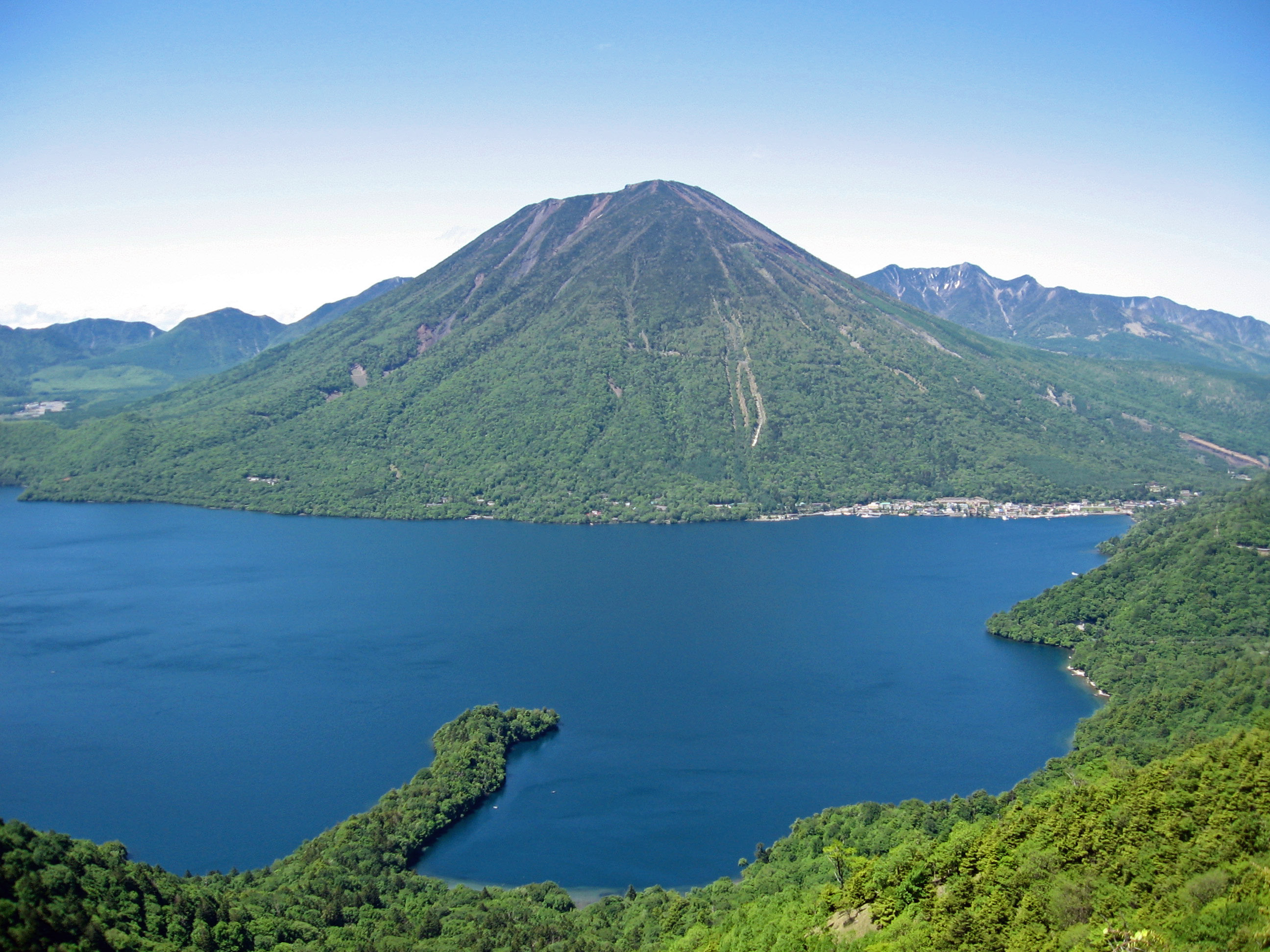 Mount Nantai and Lake Chūzenji | |
| Highest point | |
| Elevation | 2,486 m (8,156 ft)[1] |
| Listing | List of volcanoes in Japan |
| Coordinates | 36°45′43″N 139°29′38″E |
| Geography | |
 Mount Nantai Honshū, Japan | |
| Geology | |
| Mountain type | Stratovolcano |
| Last eruption | 9540 BCE ± 500 years |
Alongside Mount Nikkō-Shirane, Mount Nantai is one of the newest volcanic edifices in the National Park. Scientific studies of the volcano's geological structure began in 1957 and have established that it was formed roughly 23,000 years ago and that its last eruption was 7000 years ago.[3] The volcano was classified as active by the Japan Meteorological Agency in June of 2017.[4]
Since its first known ascent by Buddhist monk Shōdō Shōnin in the 8th century AD, Mount Nantai has become a sacred mountain and a site of pilgrimage in Buddhism and Shinto. As such, it is currently maintained by Futarasan jinja, a Shinto shrine whose go-shintai (御神体) constitutes Mount Nantai.[5] With Tōshō-gū and Rinnō-ji, the site forms the Shrines and Temples of Nikkō, a UNESCO World Heritage Site. Archaeological excavations conducted here from the 19th to 20th centuries have unearthed many artifacts, dating from the end of the Nara period in the 8th century AD to the Edo period from the 17th to 19th centuries. A few of these have been declared Important Cultural Properties by the Japanese Agency for Cultural Affairs.
Mount Nantai is listed among the 100 Famous Japanese Mountains as written by mountaineer and author Kyūya Fukada.
Toponymy
Literally, the two kanji characters that make up the name, 男 and 体, mean "man" and "body" respectively, and so together the combined word 男体 means "male body".[2] Mount Nantai is said to have been the father in a family of mountain deities in Shinto, of which the neighboring Mount Nyohō is the mother and Mount Tarō the eldest son.[6]
Trekking

The mountain is popular with hikers, and the trail to the summit starts through a gate at Futarasan Shrine's Chūgushi (中宮祠, middle shrine). The gate is open between 5 May and 25 October.[7]
Mount Nantai is one of the 100 famous mountains in Japan.
Volcanic activity
In September 2008, the Japan Meteorological Agency was asked to reclassify Mount Nantai as "active" based upon work by Yasuo Ishizaki and colleagues of Toyama University showing evidence of an eruption approximately 7000 years ago.[8]

Mount Nantai as a sacred mountain

Archaeologists affirm that during the Yayoi period the most common go-shintai (御神体) (a yorishiro housing a kami) in the earliest Shinto shrines was a nearby mountain peak supplying with its streams water, and therefore life, to the plains below where people lived.[5]
Mount Nantai constitutes Futarasan Shrine's go-shintai, and the shrine is an important example of this ancient type of mountain cult.[5] Significantly, the name Nantai (男体) itself means "man's body".[5] The mountain not only provides water to the rice paddies below, but has the shape of the phallic stone rods found in pre-agricultural Jōmon sites.[5]
See also
- List of volcanoes in Japan
- List of mountains in Japan
References
- "地理院地図 / GSI Maps|国土地理院" [GSI Maps | Geospatial Information Authority of Japan]. Geospatial Information Authority of Japan (in Japanese). Retrieved 2 January 2022.
{{cite web}}: CS1 maint: url-status (link) - Daijirin (in Japanese). Akira Matsumura, 松村明 (Dai 2-han ed.). Tōkyō: Sanseidō. 3 November 1995. ISBN 4-385-13900-8. OCLC 34720033.
{{cite book}}: CS1 maint: others (link) - Yamamoto, Takahiro (4 February 2015). "日本の主要第四紀火山の積算マグマ噴出量階段図 (日光火山群)" [Cumulative volume step-diagrams for eruptive magmas from major Quaternary volcanoes in Japan (Nikko Volcanoes)] (PDF). Geological Survey of Japan. Retrieved 3 January 2022.
{{cite web}}: CS1 maint: url-status (link) - "List of Active Volcanoes in Japan" (PDF). Japan Meteorological Agency. Retrieved 3 January 2022.
{{cite web}}: CS1 maint: url-status (link) - Hall, John Whitney (1993). Brown, Delmer (ed.). The Cambridge History of Japan, Vol. 1. Cambridge, UK: Cambridge University Press. ISBN 0-521-22352-0. OCLC 17483588.
- Fukada, Kyūya (1964). One Hundred Mountains of Japan. Martin Hood. Honolulu: University of Hawaiʻi Press. ISBN 0-8248-4785-7. OCLC 930010674.
- "Futarasan Jinja Shrine Chugushi | Temple". japantravel.navitime.com. Retrieved 26 March 2022.
- "Mount Nantai in Nikko may still be active volcano, say researchers". Mainichi Daily News. 13 September 2008. Archived from the original on 18 September 2008.
External links
- Nantai-Nyoho Volcano Group - Geological Survey of Japan
- "Nantaisan". Global Volcanism Program. Smithsonian Institution. Retrieved 24 June 2021.
| Hokkaidō | |||||||||
|---|---|---|---|---|---|---|---|---|---|
| Tōhoku region Jōshinetsu region |
| ||||||||
| Kantō region | |||||||||
| Chūbu region |
| ||||||||
| Western Japan | |||||||||
| |||||||||
This Tochigi Prefecture location article is a stub. You can help Wikipedia by expanding it. |
На других языках
[de] Nantai (Vulkan)
Der Nantai (jap. 男体山, -san) ist ein Berg im Nikkō-Nationalpark in Zentral-Honshū, der Hauptinsel Japans. Er ist 2484 Meter hoch.- [en] Mount Nantai
[fr] Mont Nantai
Le mont Nantai .mw-parser-output .prononciation>a{background:url("//upload.wikimedia.org/wikipedia/commons/thumb/8/8a/Loudspeaker.svg/11px-Loudspeaker.svg.png")center left no-repeat;padding-left:15px;font-size:smaller}Écouter (男体山, Nantaisan?) est une montagne du Japon située à Nikkō, sur l'île de Honshū, au nord de l'agglomération de Tokyo. Ce stratovolcan haut de 2 486 mètres fait partie du complexe volcanique des monts Nikkō dans le parc national de Nikkō.[ru] Нантай
Нантай (яп. 男体山 Нантайсан) — стратовулкан в национальном парке Никко, высота которого составляет 2486 метров над уровнем моря. Вулкан притягивает паломников, которые поднимаются на него для того, чтобы почтить божество храма Футарасан. Вулкан был найден священником Сёдо, который превратил Никко в религиозный центр Восточной Японии, в 782 году.Другой контент может иметь иную лицензию. Перед использованием материалов сайта WikiSort.org внимательно изучите правила лицензирования конкретных элементов наполнения сайта.
WikiSort.org - проект по пересортировке и дополнению контента Википедии