geo.wikisort.org - Mountains
Mount Aino (間ノ岳, Aino-dake), or Ainodake, is a peak of the Akaishi Mountains−Southern Alps, in Minami Alps National Park, Japan. At 3,189 m (10,463 ft), it is the fourth tallest peak in Japan and the second highest in the Akaishi Mountains.[3]
| Mount Aino | |
|---|---|
| 間ノ岳 | |
 Mount Aino and Mountain Hut Kita seen from Mount Kita in summer | |
| Highest point | |
| Elevation | 3,189.13 m (10,463.0 ft)[1] |
| Listing | 100 Famous Japanese Mountains |
| Coordinates | 35°38′46″N 138°13′42″E[2] |
| Naming | |
| English translation | middle mountain |
| Language of name | Japanese |
| Pronunciation | Japanese: [ainodake] |
| Geography | |
 Mount Aino Chūbu region, Honshu, Japan | |
| Parent range | Akaishi Mountains |
| Topo map | Geographical Survey Institute, 25000:1 間ノ岳, 50000:1 大河原 |
| Climbing | |
| Easiest route | Hike |

Its summit lies on the border of Aoi-ku and Shizuoka in Shizuoka Prefecture, and of Minami-Alps in Yamanashi Prefecture.[3] Mount Aino is one of the landmark 100 Famous Japanese Mountains.
Location
Within the Akaishi Mountains, Mount Aino is situated roughly 3 km (2 mi) south of Mount Kita, the ranges' tallest peak. Together with Mount Nōtori (農鳥岳, Nōtori-dake) to the south the three mountains may be referred to as Shiranesanzan (白峰三山, Shiranesanzan).
East of the summit lies the cirque Hosozawa Kar (細沢カール, hosozawa-karu).
Geography
Mount Aino, like most of the Shiranesanzan, abounds with alpine plants. The neighborhood is dominated by rocks where few plants can survive. It has been conceived that landslides around the summit have led to the growth of linear hollows. Taking into account such landslides, Mount Aino might have been dozens of metres higher in the past compared to its present altitude. It may have been Japan's tallest mountain during the Last Glacial Maximum. At that time, Mount Fuji had not reached its present height, and the second and third mountains (Mount Kita and Mount Hotaka) are presently only 4 and 1 metre taller, respectively.
Even though Mount Aino does not reach the height of Mount Kita, in its shape and dimension, it bears an equally great mass.
Mountain trails
Mount Aino lies on the traversal route between Mount Kita and Mount Nōtori. On the summit a trail forks towards Mount Mibu (三峰岳, Mibu-dake) in the west, where it connects to the Senshio Ridge (仙塩尾根, senshio-one) traversal route.
The nearest alpine hut is Nōtori hut (農鳥小屋, nōtori-koya), which lies on a saddle to the south below Mount Nishinōtori (西農鳥岳, Nishinōtori-dake). Another Kitadake mountain cottage (北岳山荘, kitadakesansou) is situated to the north on a saddle between Mount Aino and Mount Kita.
See also
- Minami Alps National Park
- Three-thousanders (in Japan)
- List of mountains and hills of Japan by height
Gallery
 Mount Aino in autumn
from Mount Kita Mount Aino
from Mount NishiNōtori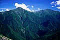

 Mout Aino shot
from Yashajin Pass,Yamanashi Prefecture


References
- "Information inspection service of the Triangulation station". Geospatial Information Authority of Japan,(間ノ岳-甲府). Archived from the original on June 9, 2009. Retrieved December 17, 2010.
- "Mountains altitude list in Japan(Yamanashi prefecture)". Geospatial Information Authority of Japan. Retrieved December 17, 2010.
- Mount Aino Archived 2017-06-18 at the Wayback Machine. (in Japanese) Minami Alps Net. Accessed July 1, 2008.
External links
- Topographic map (1:25,000)
| Hokkaidō | |||||||||
|---|---|---|---|---|---|---|---|---|---|
| Tōhoku region Jōshinetsu region |
| ||||||||
| Kantō region | |||||||||
| Chūbu region |
| ||||||||
| Western Japan | |||||||||
| |||||||||
На других языках
[de] Ainodake
Der Ainodake (japanisch 間ノ岳 .mw-parser-output .Latn{font-family:"Akzidenz Grotesk","Arial","Avant Garde Gothic","Calibri","Futura","Geneva","Gill Sans","Helvetica","Lucida Grande","Lucida Sans Unicode","Lucida Grande","Stone Sans","Tahoma","Trebuchet","Univers","Verdana"}Ainodake; bisweilen auch Aino-dake transkribiert) ist ein Berg im Akaishi-Gebirge und mit einer Höhe von 3190 m zusammen mit dem gleichhohen Hotaka-dake der dritthöchste Berg Japans. Er liegt in der Region Chūbu innerhalb des Gebietes des Minami-Alpen-Nationalparks auf der Grenze zwischen den Präfekturen Shizuoka und Yamanashi. Innerhalb des Akaishi-Gebirges liegt der Ainodake etwa 3 km südlich des Kita-dake (北岳), dem mit 3193 m höchsten Berg der Gebirgskette. Zusammen mit dem Nōtori-dake (農鳥岳) im Süden werden diese drei Berge als Shiranesanzan (白峰三山) bezeichnet.- [en] Mount Aino
[fr] Mont Aino
Le mont Aino (間ノ岳, Aino-dake?) est une montagne du Japon située dans le centre de l'île de Honshū, à la frontière entre les préfectures de Shizuoka et de Yamanashi. Elle fait partie des 100 montagnes célèbres du Japon.Другой контент может иметь иную лицензию. Перед использованием материалов сайта WikiSort.org внимательно изучите правила лицензирования конкретных элементов наполнения сайта.
WikiSort.org - проект по пересортировке и дополнению контента Википедии