geo.wikisort.org - River
The Bay of Plenty (Māori: Te Moana-a-Toi) is a region of New Zealand, situated around a bight of the same name in the northern coast of the North Island. The bight stretches 260 km from the Coromandel Peninsula in the west to Cape Runaway in the east. The Bay of Plenty Region, governed by the Bay of Plenty Regional Council, incorporates several large islands in the bay, in addition to the mainland area. Called Te Moana-a-Toi (the Sea of Toi) in the Māori language after Toi, an early ancestor, the name 'Bay of Plenty' was bestowed by James Cook in 1769 when he noticed the abundant food supplies at several Māori villages there, in stark contrast to observations he had made earlier in Poverty Bay.
It has been suggested that this article should be split into articles titled Bay of Plenty and Bay of Plenty Region. (discuss) (June 2022) |
| Bay of Plenty | |
|---|---|
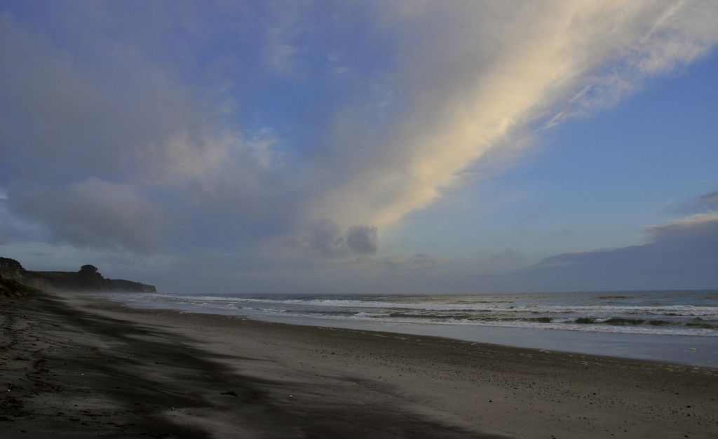
 The Bay of Plenty seen from Whakatāne. The Whakatane River (foreground) is one of eight major rivers that empty into the bay. | |
 Bay of Plenty in North New Zealand | |
| Location | |
| Country | New Zealand |
| Largest City | Tauranga |
| Physical characteristics | |
| Mouth | |
• coordinates | 37°40′S 177°00′E |
| Basin features | |
| River system | Pacific Ocean |
| Tributaries | |
| • left | Raukokore River, Kereu River, Haparapara River Motu River, Hawai River, Waioeka River |
| • right | Waiotahe River, Whakatane River, Rangitaiki River Tarawera River, Kaituna River, Wairoa River Wainui River, Aongatete River, Otahu River Wentworth River, Wharekawa River |
Bay of Plenty
Te Moana-a-Toi (Māori) | |
|---|---|
Region | |
 Bay of Plenty Region in New Zealand | |
| Country | New Zealand |
| Island | North Island |
| Seat | Whakatāne |
| Government | |
| • Chairperson | Doug Leeder |
| Area | |
| • Total | 12,231 km2 (4,722 sq mi) |
| • Land | 12,072.00 km2 (4,661.03 sq mi) |
| Population (June 2022)[1] | |
| • Total | 347,700 |
| • Density | 28/km2 (74/sq mi) |
| Time zone | UTC+12 (NZST) |
| • Summer (DST) | UTC+13 (NZDT) |
| ISO 3166 code | NZ-BOP |
| HDI (2017) | 0.902[2] very high · 11th |
| Website | www |
History
According to local Māori traditions, the Bay of Plenty was the landing point of several migration canoes that brought Māori settlers to New Zealand. These include the Mātaatua, Nukutere, Tākitimu, Arawa and Tainui canoes. Many of the descendent iwi maintain their traditional homelands (rohe) in the region, including Te Whānau-ā-Apanui, Te Whakatōhea, Ngāi Tai, Ngāi Tūhoe, Ngāti Awa, Ngāti Tūwharetoa ki Kawerau, Te Arawa, Ngāi Te Rangi, Ngāti Ranginui and Ngāti Pūkenga.[3] Māori named the bay Te Moana-a-Toi (the Sea of Toi) after Toi, an early ancestor of the Mātaatua tribes.[3] Early Māori settlement also gave rise to many of the town and city names used today.
The first recorded European contact came when James Cook sailed through the Bay of Plenty in 1769. Cook noted the abundance of food supplies, in comparison to Poverty Bay further back along the eastern coast of the North Island. Further reports of European contact are scarce prior to the arrival of missionary Samuel Marsden to the Tauranga area in 1814. Bay whaling stations operated in the bay during the 19th century.[4]
During the 1820s and 1830s, northern iwi including Ngā Puhi invaded the Bay of Plenty during their campaign throughout the North Island, fighting local Māori tribes in what became known as the Musket Wars. However, the 1830s and 1840s saw increased contact between Bay of Plenty Māori and Europeans through trade,[5] although few Europeans settled in the region.[6] Missionary activity in the region also increased during this time.[3] In 1853, New Zealand was subdivided into provinces, with the Bay of Plenty incorporated into Auckland Province.
Conflict returned to the Bay of Plenty during the 1860s with the New Zealand Wars. Initially this stemmed from Tauranga iwi supporting the Waikato iwi in their conflict with the government. In retaliation, British Crown and government-allied Māori forces attacked the Tauranga iwi, including at the famous Battle of Gate Pā in 1864. Further conflict with the government arose in 1865 when German missionary Carl Völkner and interpreter James Fulloon were killed by local Māori at Ōpōtiki and Whakatāne, respectively. The ensuing conflict resulted in the confiscation of considerable land from several Bay of Plenty iwi by the government.[3]
Confiscation of Māori land deprived local iwi of economic resources (among other things), and also provided land for expanding European settlement. The government established fortified positions, including at Tauranga, Whakatāne and Ōpōtiki. European settlers arrived throughout the latter half of the 19th century, establishing settlements in Katikati, Te Puke and the Rangitaiki area. In 1876, settlements were incorporated into counties following the nationwide dissolution of the provincial system. Initial settlements in the region struggled: the climate was ill-suited to sheep farming and the geography was inaccessible, further hindered by a lack of infrastructure. By the end of the century the population had started to dwindle. But after experimenting with different crops, settlers found success with dairy production. Dairy factories sprang up across the Bay of Plenty in the 1900s, with butter and cheese feeding economic prosperity throughout the early 20th century; local Māori continued to live on the fringe of this prosperity. Timber also became a major export in the 1950s, as kiwifruit did later.[3]
The present Bay of Plenty region was formed in 1989 after a nationwide review and shakeup of top-level local government in New Zealand. The new region incorporated the former counties of Tauranga, Rotorua, Whakatāne and Ōpōtiki.
On 5 October 2011, the MV Rena ran aground on the Astrolabe Reef in the bay causing a large oil spill,[7][8] described as New Zealand's worst ever environmental disaster.[9]
A volcanic eruption occurred on White Island at 14:11 on 9 December 2019, which resulted in twenty fatalities and twenty-seven injuries, most suffering severe burns. Forty-seven people were reportedly on the island when it erupted. A second eruption closely followed the first.
Governance
The region is subdivided into territorial authorities, which include the Western Bay of Plenty District, Tauranga City, Whakatane District, Kawerau District and Ōpōtiki District, as well as parts of Rotorua District and the town of Rangitaiki in Taupo District.
Bay of Plenty Regional Council is responsible for overseeing regional land use, environmental management and civil defence in the region.[10]
Public health in New Zealand is broken into regions. The Bay of Plenty and Lakes district health boards have public health provided by Toi Te Ora – Public Health.
Geography


The Bay of Plenty region covers 12,200 km2 (4,700 sq mi) of land and 9,500 km2 (3,700 sq mi) of coastal marine area.[11] It extends along the eastern coast of the North Island, from the base of the Coromandel Peninsula in the west to Cape Runaway in the east. The region extends 12 nautical miles from the mainland coastline, and also extends from the coastlines of several islands in the bay, notably Mayor Island/Tuhua, Motiti Island, Whale Island and the active volcano of Whakaari/White Island. It extends inland to the sparsely populated forest lands around Rotorua and Murupara.
The geographical bay is defined by 259 km of open coastline used for economic, recreational and cultural purposes. The coastline from Waihi Beach in the west to Opape is defined as sandy coast, while the coast from Opape to Cape Runaway is rocky shore.[12] Sizeable harbours are located at Tauranga, Whakatāne and Ohiwa. Major estuaries include Maketu, Little Waihi, Whakatāne, Waiotahe and Waioeka/Otara. Eight major rivers empty into the bay from inland catchments, including the Wairoa, Kaituna, Tarawera, Rangitaiki, Whakatane, Waioeka, Motu and Raukokore rivers.[11] The region has more than 200 km2 (77 sq mi) of lakes, known as the Lakes of Rotorua.
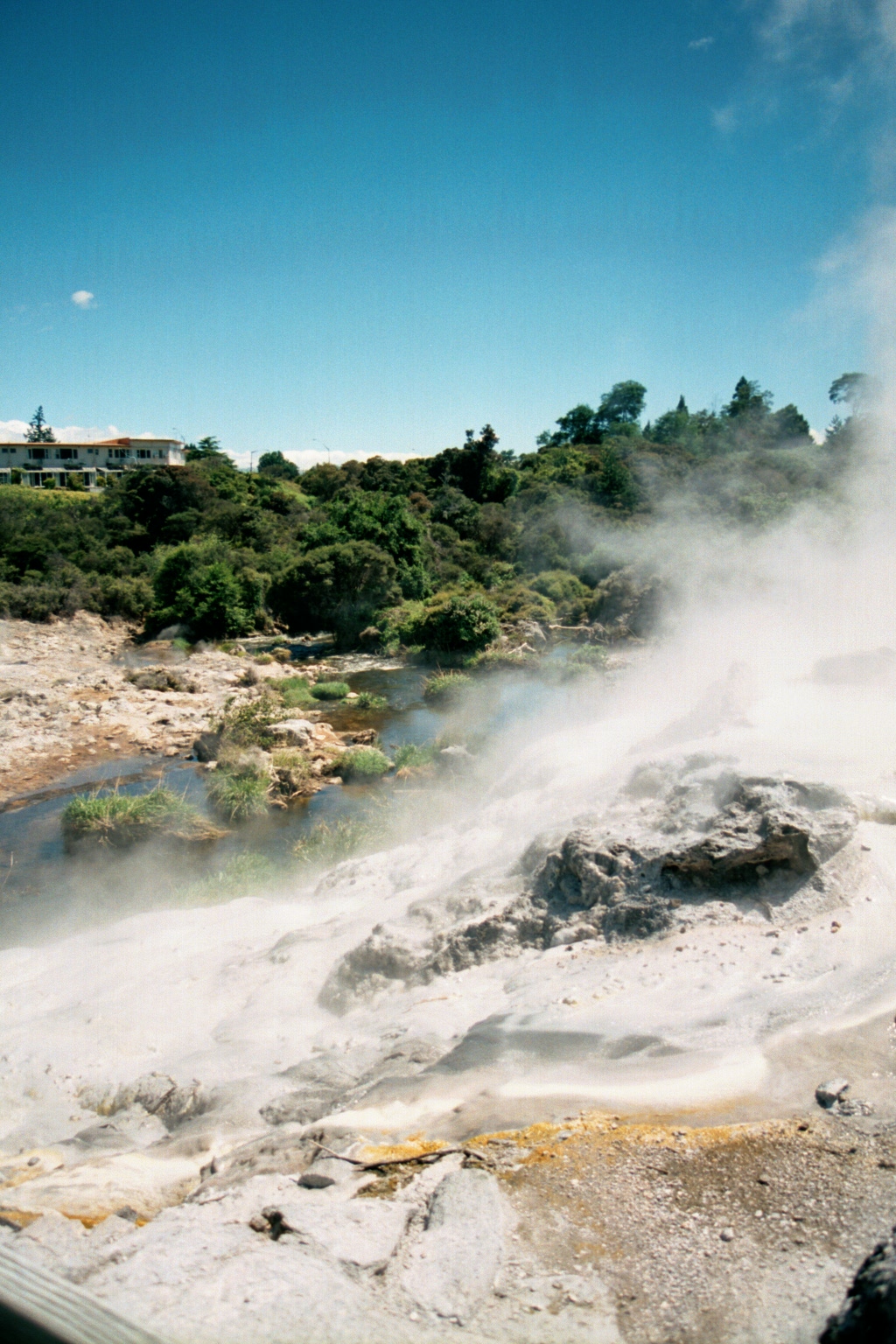
Much of the central part of the region lies within the Taupo Volcanic Zone, which extends from the centre of the North Island northwards to Whakaari/White Island. Volcanic mountains and lakes, geothermal areas and geological fault lines all dot the landscape. The geothermal region around Rotorua is a major tourist site, while many hot springs in the region are used as swimming areas. The geothermal field near Kawerau is the site of a geothermal power plant that will reportedly meet up to one third of residential and industrial electricity demand in the Eastern Bay of Plenty.[13] Whakaari/White Island, the site of a former sulfur-mining operation, is an active volcanic island popular with tourists. The eruption of Mount Tarawera in 1886 and the 1987 Edgecumbe earthquake were two disasters related to geological activity in the volcanic plateau.
Prominent volcanic cones in the region include Mount Maunganui, Mount Tarawera and Mount Edgecumbe/Putauaki. These features also have cultural significance to local Māori. The Kaimai and Mamaku mountain ranges lie at the western border of the region. Swamp land was formerly concentrated around a number of rivers, but much of this was dredged in the early part of the 20th century to increase land for settlement and other uses.[3] Large native and foreign (planted) forest areas are found in the inland parts of the region. The Kaingaroa Forest is the world's largest planted forest, comprising radiata pine mainly used for timber.
The bay contains numerous islands, notably the active volcano Whakaari / White Island. Whakaari/White Island ([faˈkaːɾi]; also known as just White Island) is an active andesite stratovolcano situated in the Bay of Plenty. It is New Zealand's most active cone volcano, and has been built up by continuous volcanic activity over the past 150,000 years.[14] The nearest mainland towns are Whakatāne and Tauranga. The island has been in a nearly continuous stage of releasing volcanic gas at least since it was sighted by James Cook in 1769. Whakaari erupted continually from December 1975 until September 2000, marking the world's longest historic eruption episode, according to GeoNet, and also in 2012, 2016, and 2019.
The island is roughly circular, about 2 km (1.2 mi) in diameter, and rises to a height of 321 m (1,053 ft) above sea level. It covers an area of approximately 325 ha (800 acres).[15] The exposed island is only the peak of a much larger submarine volcano, which rises up to 1,600 m (5,249 ft) above the nearby seafloor. Sulphur was mined on the island until the 1930s. Ten miners were killed in 1914 when part of the crater wall collapsed.
The main activities on the island now include guided tours and scientific research. Access to the island is allowed only as a member of a tour run by a registered tour operator.
The Waimangu Geyser – to be seen 1900–1904 – erupted frequently, was the most powerful geyser in the world and killed 4 people in 1903.
Population
Bay of Plenty Region covers 12,072.00 km2 (4,661.03 sq mi)[16] and had an estimated population of 347,700 as of June 2022,[1] with a population density of 29 people per km2.
| Year | Pop. | ±% p.a. |
|---|---|---|
| 1991 | 203,982 | — |
| 1996 | 224,364 | +1.92% |
| 2001 | 239,415 | +1.31% |
| 2006 | 257,379 | +1.46% |
| 2013 | 267,741 | +0.57% |
| 2018 | 308,499 | +2.87% |
| Source: [17][18] | ||
Bay of Plenty Region had a population of 308,499 at the 2018 New Zealand census, an increase of 40,758 people (15.2%) since the 2013 census, and an increase of 51,120 people (19.9%) since the 2006 census. There were 110,919 households. There were 150,366 males and 158,133 females, giving a sex ratio of 0.95 males per female. The median age was 40.2 years (compared with 37.4 years nationally), with 64,182 people (20.8%) aged under 15 years, 53,832 (17.4%) aged 15 to 29, 133,386 (43.2%) aged 30 to 64, and 57,096 (18.5%) aged 65 or older.
Although some people objected to giving their religion, 49.9% had no religion, 34.6% were Christian, 1.1% were Hindu, 0.3% were Muslim, 0.5% were Buddhist and 6.6% had other religions.
Of those at least 15 years old, 43,086 (17.6%) people had a bachelor or higher degree, and 46,263 (18.9%) people had no formal qualifications. The median income was $29,100, compared with $31,800 nationally. 35,295 people (14.4%) earned over $70,000 compared to 17.2% nationally. The employment status of those at least 15 was that 114,264 (46.8%) people were employed full-time, 37,503 (15.4%) were part-time, and 10,926 (4.5%) were unemployed.[17]
The Bay of Plenty is the fifth-most populous region in New Zealand, accounting for 6.8% of the national population.[1]
The coast is dotted with several sizeable settlements, the largest of which is the conurbation of the city of Tauranga and its neighbour Mount Maunganui in the west. The town of Whakatāne is located in the centre of the coast. Other towns of note include Waihi Beach, Katikati, Maketu, Pukehina Beach and Ōpōtiki.
Most of the population along the coast is concentrated in the western and central parts of the shore; the eastern part is sparsely populated hill country. The region has the third-highest regional population density in New Zealand, with only the 11th-largest land area. The major population centres are Tauranga, Rotorua and Whakatāne.
Significant horticultural, forestry and tourism industries are well established in the region. However, the Bay of Plenty is the third-most economically deprived region in New Zealand, with the eastern districts being among the least economically developed in the country.[19] However, in 2011 Business & Economic Research Limited (BERL) identified the Bay of Plenty as one of the top performing regions in economic development, ranking second behind Auckland. It had the highest employment and GDP growth for 2011 and had the fastest growing medium term GDP. Tauranga, the region's largest commercial centre, was named New Zealand's top city for economic performance for the 2011 year.
Urban areas
| Name | Population (June 2022)[1] |
% of region |
|---|---|---|
| Tauranga | 158,300 | 45.5% |
| Rotorua | 57,900 | 16.7% |
| Whakatāne | 16,700 | 4.8% |
| Te Puke | 10,250 | 2.9% |
| Kawerau | 7,760 | 2.2% |
| Katikati | 5,530 | 1.6% |
| Ōpōtiki | 5,350 | 1.5% |
| Ngongotahā | 5,180 | 1.5% |
| Ōmokoroa | 3,990 | 1.1% |
| Ōhope | 3,290 | 0.9% |
| Waihi Beach | 2,760 | 0.8% |
| Murupara | 2,000 | 0.6% |
| Edgecumbe | 1,800 | 0.5% |
Culture and identity
| Largest groups of overseas-born residents[20] | |
|---|---|
| Nationality | Population (2018) |
| England | 14,817 |
| India | 6,393 |
| Australia | 5,562 |
| South Africa | 4,299 |
| Philippines | 2,703 |
| China | 1,848 |
| Scotland | 1,770 |
| Netherlands | 1,563 |
| United States of America | 1,479 |
| South Korea | 1,434 |
In the 2018 census, ethnicities were 73.6% European/Pākehā, 29.1% Māori, 3.5% Pacific peoples, 7.2% Asian, and 1.8% other ethnicities. People may identify with more than one ethnicity.
Only 18.6% of the regional population was born overseas, compared with 27.1% nationally. English is the most widely spoken language. Te Reo Māori is the most common minority language, spoken by 8.6% of the population, compared with 4.0% nationally.[17]
Climate
The Bay of Plenty has a temperate, maritime climate,[21] with warm, humid summers and mild winters. It is one of the warmest regions in New Zealand, particularly along the coastline, and most areas experience at least 2,200 hours of sunshine per annum. Average daily maximum temperatures range from 10 to 16 °C (50 to 61 °F) in winter and 22 to 26 °C (72 to 79 °F) in summer. Typical minima vary from 0 to 9 °C (32 to 48 °F) in winter and 11 to 17 °C (52 to 63 °F) during summer. Rainfall occurs more frequently in winter than in summer, but tropical storms in summer and autumn can produce heavy rain with high winds.[22] Central parts of the region can receive up to 2000 mm of rainfall annually, while the eastern and western areas can receive up to 4000 mm.[21]
Economy
The subnational gross domestic product (GDP) of Bay of Plenty was estimated at NZ$17.24 billion in the year to March 2019, 5.7% of New Zealand's national GDP. The subnational GDP per capita was estimated at $53,700 in the same period. In the year to March 2018, primary industries contributed $1.89 billion (11.6%) to the regional GDP, goods-producing industries contributed $3.24 billion (20.0%), service industries contributed $9.72 billion (59.8%), and taxes and duties contributed $1.39 billion (8.6%).[23]
Agriculture, natural resources and tourism are the major industries. Most (96 per cent) of the region is defined as 'rural', with 22% of land usage representing farm land and 38% representing nature reserve land.[19] The most common agricultural land uses are horticulture, dairy, grazing and sheep farming. The region has over 11,500 hectares of horticultural land, predominantly producing kiwifruit and avocadoes.[24] The region also has an abundance of coastal, forestry and geothermal resources. Forestry emerged as a vital industry in the 1950s, with radiata pine being planted during the early 20th century. Forestry is commercially planted and managed, mostly using planted foreign tree species, and timber is sent to the Port of Tauranga for export. Geothermal activity is a source of tourism, and geothermal energy is emerging as a major regional source of electricity. Tourism is the other notable industry, accounting for 15% of the region's GDP from March 2000 to 2004.[25]
Overall economic growth in the Bay of Plenty averaged 2.1% between March 2000 and 2004, compared with the national rate of 3.5%, although per capita real GDP growth in the five years to March 2003 matched the national growth rate at an averaged 2.3%.[25] In the 2013 Census, the median annual income was $26,200, below the national median of $28,500. Further, 39.3% of people aged 15 years or older earned an annual income of less than $20,000, compared with 38.2% of people nationally.[26] Unemployment was at 9.0% of people 15 years or older, compared with 7.1% nationally.[27]
Tourism
The Bay of Plenty is a popular holiday destination due to the warm and sunny summer climate and public beaches. The Bay of Plenty received over 645,000 tourists in 2003, equivalent to one in three visitors to New Zealand coming to the region.[25] Rotorua is a popular destination for international visitors, in particular the surrounding geothermal areas and Māori cultural centres. Tauranga is a popular domestic tourism destination, and also becoming popular internationally. Whale watching has become a popular attraction as the number of whales such as blue whales and humpback whales migrating into bay waters began to recover.[28]
Transport
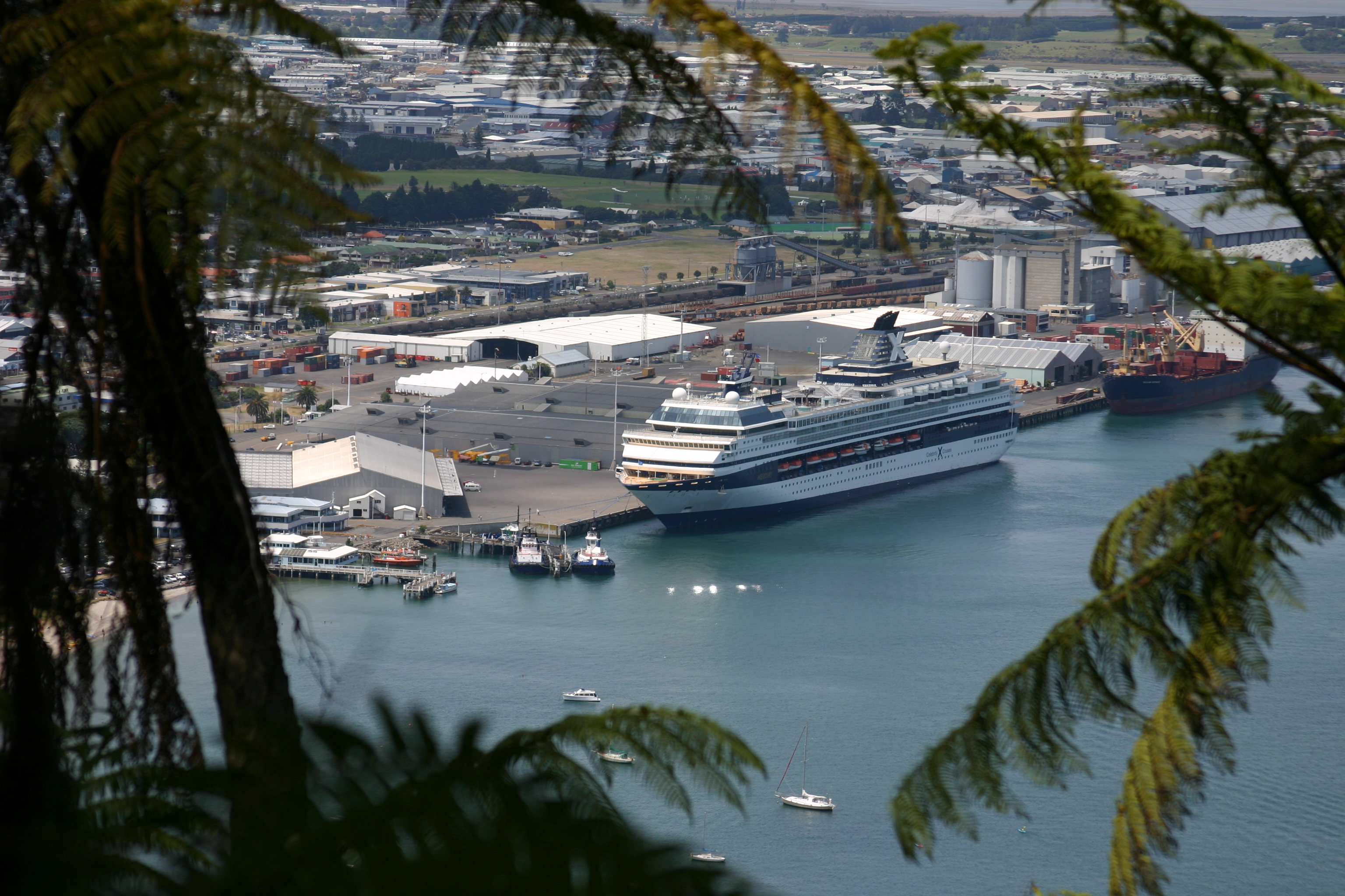
The Bay of Plenty has 227 kilometres (141 mi) of rail network and 4,460 kilometres (2,770 mi) of roads.[19] The main rail line in the region is the East Coast Main Trunk Railway, which extends from Hamilton in the Waikato region to Kawerau via Tauranga, with the Murupara Branch Railway extending the Kawerau terminus to Murupara, and the Mount Maunganui Branch connecting the Mount Maunganui terminus with the East Coast Main Trunk. Rail networks in the region are used exclusively for freight. The hub of regional economic activity is the Port of Tauranga, with well-established rail and road connections to other parts of the region. Three commercial airports also operate in the Bay of Plenty: Tauranga Airport, Rotorua Airport and Whakatane Airport.
Car travel remains the dominant form of transport in the region. In 2002, the number of vehicles owned in the region was 189,000, with an average of 1.51 vehicles per household.[19] Public transport bus services exist only in Tauranga and Rotorua. Significant growth in the Western Bay of Plenty District has seen increased strain on road infrastructure, particularly with increasing traffic congestion in Tauranga. Due to this growth, a new highway network is being planned and constructed in Tauranga to join with its current network spanning on the western side of the city. The NZ Transport Agency, in conjunction with Environment Bay of Plenty, Tauranga City and the Western Bay of Plenty District Councils, is planning to build an Eastern Motorway bypassing Te Puke, a Western Motorway bypassing Ōmokoroa and a smaller Southern Motorway.[29]
Sport
The Bay of Plenty is represented in several domestic sporting competitions. The Bay of Plenty Rugby Union oversees the Bay of Plenty Steamers, who play in the Mitre10 Cup. The Steamers are also a feeder club for the Chiefs who play in the Super Rugby competition. The Waikato/Bay of Plenty Magic compete in the ANZ Championship in netball, having previously played in the National Bank Cup. Bay of Plenty also makes up a part of the Northern Districts cricket region and the Midlands hockey region.
Media
Magazines
- Plenty Magazine
- UNO. Magazine
- focus magazine
Newspapers
- Weekend Sun/SunLive
- Bay of Plenty Times
- Rotorua Daily Post
- Te Puke Times
- Opotiki News
- Whakatane Beacon
Radio stations
- The Hits Rotorua
- The Hits Bay of Plenty
- 89.4 ZM – Hits
- 90.2 Newstalk ZB – Talk
- 90.5 1XX – Adult Contemporary
- 91.0 Radio Hauraki – Classic Rock
- 91.4 Radio New Zealand Concert – Classical
- 92.6 The Sound – Classic Rock
- 92.9 1XX – Adult Contemporary
- 93.4 More FM – Hits
- 93.7 Bayrock – Rock
- 97.7 and 99.3 Q97 – Hits
- 94.2 The Rock FM – Rock
- 95.0 Classic Hits – 80s / 90s
- 97.4 Coast – Easy Listening
- 99.0 Radio Sport – Sports
- 99.8 The Edge – Hits
- 100.1 Bayrock – Rock
- 101.0 Radio New Zealand National – Talk
- 105.4 BollyBOP FM – Hits[30]
Television
- TV Central (Freeview Channel 30) – Bay of Plenty & Waikato (shut down in April 2015)
- TV Rotorua-Rotorua (shut down in December 2013)
- Geyser Television-Rotorua (shut down in December 2013)
Notable people
- Te Purewa (?–1842?), tribal leader, war leader and peacemaker
- Maharaia Winiata (1912–1960), a New Zealand tribal leader, Methodist minister, teacher, anthropologist, broadcaster and community leader
Sister provinces
- Jiangxi Province, China
See also
- List of schools in the Bay of Plenty Region
References
- "Subnational population estimates (RC, SA2), by age and sex, at 30 June 1996-2022 (2022 boundaries)". Statistics New Zealand. Retrieved 25 October 2022. (regional councils); "Subnational population estimates (TA, SA2), by age and sex, at 30 June 1996-2022 (2022 boundaries)". Statistics New Zealand. Retrieved 25 October 2022. (territorial authorities); "Subnational population estimates (urban rural), by age and sex, at 30 June 1996-2022 (2022 boundaries)". Statistics New Zealand. Retrieved 25 October 2022. (urban areas)
- "Sub-national HDI – Area Database – Global Data Lab". hdi.globaldatalab.org. Retrieved 13 September 2018.
- McKinnon, Malcolm (27 September 2007). "Bay of Plenty". Te Ara – the Encyclopedia of New Zealand. Archived from the original on 20 March 2008. Retrieved 25 February 2008.
- Don Grady (1986), Sealers & whalers in New Zealand waters, Auckland, Reed Methuen, p. 150. ISBN 0-474-00050-8
- "Our History". Tourism Bay of Plenty. Archived from the original on 7 February 2012. Retrieved 25 February 2008.
- "Bay of Plenty History". New Zealand Tourism Guide. Retrieved 10 October 2011.
- "Tauranga incident response update". Maritime New Zealand. 5 October 2011. Archived from the original on 18 October 2011. Retrieved 13 October 2011.
- "M/V Rena Information". Costamare Inc. 7 October 2011. Archived from the original on 20 July 2012. Retrieved 12 October 2011.
- "Worst ever environmental disaster". The New Zealand Herald. 11 October 2011. Retrieved 11 October 2011.
- "Bay of Plenty – New Zealand Travel". newzealandtravel.org.
- "Our Region". Environment Bay of Plenty. Archived from the original on 18 February 2008. Retrieved 3 March 2008.
- "Our Coast". Environment Bay of Plenty. Archived from the original on 16 January 2008. Retrieved 3 March 2008.
- "Mighty River Power media release: Generation Equipment Arriving at Kawerau". 18 October 2007. Archived from the original on 9 October 2008. Retrieved 23 June 2008.
- "White Island". GeoNet. Retrieved 30 December 2012.
- Scheffel, Richard L.; Wernet, Susan J., eds. (1980). Natural Wonders of the World. United States of America: Reader's Digest Association, Inc. p. 412. ISBN 978-0-89577-087-5.
- "ArcGIS Web Application". statsnz.maps.arcgis.com. Retrieved 26 February 2022.
- "Statistical area 1 dataset for 2018 Census". Statistics New Zealand. March 2020. Bay of Plenty Region (04). 2018 Census place summary: Bay of Plenty Region
- "2001 Census: Regional summary". archive.stats.govt.nz. Retrieved 28 April 2020.
- Environment Bay of Plenty (September 2004). "Bay of Plenty Regional Land Transport Strategy" (PDF). pp. 15–32. Archived from the original (PDF) on 11 April 2008. Retrieved 28 February 2008.
- "Birthplace (detailed), for the census usually resident population count, 2006, 2013, and 2018 Censuses (RC, TA, SA2, DHB)". Statistics New Zealand.
- Mullan, Brett; Tait, Andrew; Thompson, Craig (21 September 2007). "Regional Climate". Te Ara – the Encyclopedia of New Zealand. Archived from the original on 11 April 2008. Retrieved 7 March 2008.
- "Climate Change". Environment Bay of Plenty. Archived from the original on 13 February 2008. Retrieved 3 March 2008.
- "Regional gross domestic product: Year ended March 2019 | Stats NZ". www.stats.govt.nz. Retrieved 21 May 2020.
- "Fresh Facts: New Zealand Horticulture" (PDF). Plant & Food Research. 2018. ISSN 1177-2190.
- New Zealand Institute of Economic Research (1 November 2005). "Bay of Plenty Economic Profile". Regional Economic Performance: Final Report. New Zealand Ministry of Economic Development. Archived from the original on 4 April 2008. Retrieved 28 February 2008.
- 2013 Census QuickStats about a place (Income) : Bay of Plenty Region
- 2013 Census QuickStats about a place (Work) : Bay of Plenty Region
- "Kim Westerskov Photography". Archived from the original on 1 April 2016. Retrieved 27 April 2014.
- "Integrated Transport Strategy for Tauranga" (PDF). Tauranga City Council. Archived from the original (PDF) on 15 October 2008. Retrieved 21 April 2008.
- "Radio FM – Bay of Plenty – Radio Stations NZ – Easy Listening Rock Hits". radiofm.co.nz.
External links
- Bay of Plenty Times – regional newspaper
- Bay of Plenty in Te Ara the Encyclopedia of New Zealand
- Bay of Plenty Area Information
Regions of New Zealand | ||
|---|---|---|
| North Island | ||
| South Island |
| |
* Governed by a unitary authority rather than a regional council | ||
Authority control | |
|---|---|
| General | |
| National libraries | |
| Other |
|
На других языках
- [en] Bay of Plenty
[ru] Пленти (залив)
Пленти (англ. Bay of Plenty) — крупный залив на северном побережье новозеландского острова Северный. Он простирается от полуострова Кормандел[en] на западе до мыса Ранавей[en] на востоке. Длина береговой линии залива составляет около 259 км. У побережья залива Пленти расположен одноимённый регион Бей-оф-Пленти, который также включает несколько крупных островов в заливе.Другой контент может иметь иную лицензию. Перед использованием материалов сайта WikiSort.org внимательно изучите правила лицензирования конкретных элементов наполнения сайта.
WikiSort.org - проект по пересортировке и дополнению контента Википедии