geo.wikisort.org - Island
The Northwestern Hawaiian Islands or Leeward Hawaiian Islands are the small islands and atolls in the Hawaiian island chain located northwest (in some cases, far to the northwest) of the islands of Kauai and Niihau. Politically, they are all part of Honolulu County in the U.S. state of Hawaii, except Midway Atoll, which is a territory distinct from the State of Hawaii, and grouped as one of the United States Minor Outlying Islands.[1] The United States Census Bureau defines this area, except Midway, as Census Tract 114.98 of Honolulu County. Its total land area is 3.1075 square miles (8.048 km2). All the islands except Nihoa are north of the Tropic of Cancer, making them the only islands in Hawaii that lie outside the tropics.
 The Northwestern Hawaiian Islands form part of the Hawaiian island chain | |
 NW Hawaiian Islands Location of the Northwestern Hawaiian Islands in the Pacific Ocean  NW Hawaiian Islands NW Hawaiian Islands (Hawaiian Islands) | |
| Geography | |
|---|---|
| Location | Pacific Ocean |
| Coordinates | 25°00′N 169°00′W |
| Archipelago | Hawaiian Islands |
| Administration | |
United States | |
| State/Territory | Hawaii and Midway Island |
The Northwestern or Leeward Hawaiian Islands include:
- Nihoa (Moku Manu) at 23°03′38″N 161°55′19″W
- Necker (Mokumanamana) at 23°34′N 164°42′W
- French Frigate Shoals (Kānemilohaʻi) at 23°52.134′N 166°17.16′W
- Gardner Pinnacles (Pūhāhonu) at 25°01′N 167°59′W
- Maro Reef (Nalukākala) at 25.415°N 170.590°W
- Laysan (Kauō) at 25.7675°N 171.7334°W
- Lisianski (Papaʻāpoho) at 26.064031°N 173.965802°W
- Pearl and Hermes Atoll (Holoikauaua) at 27.927687°N 175.737991°W
- Midway Atoll (Pihemanu) at 28°12′N 177°21′W - not part of the State of Hawaii
- Kure Atoll (Mokupāpapa) at 28°25′N 178°20′W
The Islands

- 156-acre (0.63 km2) Nihoa is the youngest of the NWHI, and the tallest, with 900-foot (270 m) vertical cliffs. It represents the southwestern part of the island's former volcanic cone. Ancient Hawaiians might have stayed here long-term.
- 40-acre (160,000 m2) Necker Island is hook-shaped and 270 feet (82 m) tall at its summit. Barren of vegetation, it was used by Ancient Hawaiians for religious purposes, but not for long-term habitation.
- French Frigate Shoals is an atoll, the largest region of coral reefs in Hawaii, at 200 square miles (520 km2). The atoll is composed of a dozen or so small islands, one of which (Tern Island) contains an airport and human habitations.
- Gardner Pinnacles is made up of two small basalt peaks, the last rocky island in Hawaii. While the island itself is tiny, the surrounding reef is expansive and diverse.
- 166-square-mile (430 km2) Maro Reef is an extremely fertile reef system that has been described as a "coral garden".
- Laysan is a 913-acre (3.69 km2), low, sandy island with a natural lake in its interior, one of only five such lakes in Hawaii. It has arguably the most diverse ecosystem in the NWHI, and hosts about two million seabirds of seventeen species.[2]
- Lisianski Island, only 400 acres (1.6 km2), is geologically akin to Laysan, without the lake. Though the island is slightly less biodiverse, the surrounding reef is very fertile.
- Pearl and Hermes Atoll is an atoll very similar to French Frigate Shoals, but with much less dry land. For this reason, it was mostly ignored by guano miners and feather hunters.
- Midway Atoll is the most commonly known of the NWHI, and is also the largest. The Battle of Midway was fought here and in its surrounding waters, and the island remains permanently inhabited, albeit by persons who are there in consequence of their service with the United States Government, not an indigenous population.
- Circular Kure Atoll contains the 236-acre (0.96 km2) Green Island, which used to host a LORAN station and a runway, but these have since been demolished. Kure is one of the less biodiverse islands of the NWHI.

Other islands or reefs were previously mapped as part of this chain but are now considered to be either phantom islands or misidentifications of existing islands. The following reefs continued to appear on maps as late as 1934:[3]
- Two Brothers Reef, site of the 1823 Two Brothers shipwreck, originally placed west of French Frigate Shoals but later proven to be identical with the latter.[4]
- "Krusenstern Reef," "Krusenstern Rock," or "Krusenstern Island" was a phantom reef at 22°15′N 175°37′W south of Lisianski Island; an investigation in 1923 declared it nonexistent.[5][6]
Geology
The Northwestern Hawaiian Islands were formed approximately 7 to 30 million years ago, as shield volcanoes over the same volcanic hotspot that formed the Emperor Seamounts to the north and the Main Hawaiian Islands to the south.[7] As the Pacific Plate moved north and later northwest over the hot spot, volcanic eruptions built up islands in a linear chain. The isolated land masses gradually eroded and subsided, evolving from high islands in the south, much like the Main Islands of Hawaii, to atolls (or seamounts) north of the Darwin Point. Each of the NWHI are in various stages of erosion. Nihoa, Necker, and Gardner Pinnacles are rocky, basalt islands that have not eroded enough to form an atoll, or that lack a substantial coral reef. Laysan and Lisianski are low, sandy islands that have been eroded longer. French Frigate Shoals, Pearl and Hermes, Midway, and Kure are atolls.
North of the Darwin Point, the coral reef grows more slowly than the island's subsidence, and as the Pacific Plate moves northwest, the island becomes a seamount when it crosses this line. Kure Atoll straddles the Darwin Point, and will sink beneath the ocean when its coral reef cannot keep up with the rate of subsidence, a destiny that awaits every Hawaiian island.[8]
Biodiversity and Endemism
The Hawaiian Islands are about 2,500 miles (4,000 km) from North America and 3,800 miles (6,100 km) from Asia, and it is because of this isolation that the Hawaiian Islands have extraordinary numbers of unique species.[9] Only a species that could fly or swim immense distances could reach the archipelago. But whereas Polynesians, and later, Europeans, have largely altered the ecosystem of the Main Hawaiian islands by introducing alien species, the ecosystems of the NWHI remain, for the most part, intact. The extensive coral reefs found in Papahānaumokuākea are home to over 7,000 marine species.[10] Of the many species that live here, over 1,700 species of organisms are endemic to the Hawaiian Islands (i.e., they are found nowhere else). For this reason, the region has been dubbed "America's Galápagos".
Though not subject to nearly as much extinction as the main islands, the Leeward Islands have had their share of abuse. From the late 19th to the early 20th centuries, fishermen, guano miners, and feather hunters killed most of the birds and sea life living in the NWHI. Rabbits were introduced to Laysan and Lisianski, where they multiplied and devoured most of the vegetation, permanently extinguishing several species. However, most of the damage was reversed, and the islands were restored largely to their pre-exploitation state.
Important Bird Area
The NWHI has been recognized as an Important Bird Area (IBA) by BirdLife International because of its seabirds and endemic landbirds. The seabird colonies in the IBA form one of the largest assemblages of tropical seabirds in the world, with over 14 million birds of 21 species.[11]
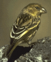
Some of the endemic species of the NWHI include the Nihoa and Laysan finch, the Laysan duck (the "rarest native waterfowl in the United States"),[12] and the Nihoa fan palm. Other notable species are the Laysan albatross, the highly endangered Hawaiian monk seal, and the green sea turtle. The only native trapdoor spiders in the Hawaiian archipelago (Nihoa spp.), recently discovered, are found here. Most endemic species are highly vulnerable to extinction as one major catastrophic event could wipe out all of the vegetation on each small island. Additionally, seventy percent of all coral reefs in the United States are found here.
Exploration
Archeological evidence suggests ancient Hawaiians visited but did not live on Mokumanamana (Necker) and French Frigate Shoals, and the islands were deserted when Europeans arrived in the 18th century. Agricultural terraces indicate Hawaiians lived on Nihoa for extended periods of time. Mokumanamana lacks vegetation and is unsuitable for agriculture, and archeological studies indicate early Hawaiians only visited and used the island for religious purposes.
The first of the Leeward Isles to be discovered by Europeans was Nihoa. James Colnett discovered it in 1786, although historically the credit has gone to William Douglas. Later that year, La Pérouse discovered Necker, and named it for Jacques Necker, the French Minister of Finance. La Pérouse then went on to discover French Frigate Shoals. The last of the NWHI to be discovered was Midway Atoll, which was found by N.C. Middlebrooks in 1859. In 1925, the Tanager Expedition travelled to many of the NWHI. The islands were mapped, new species were discovered and described, and the archeological sites on Nihoa and Necker were found.
Naming system
Most of the islands have two names: one in English and one in Hawaiian (indicated in parentheses above). The majority of the Hawaiian names used as alternatives to the English ones were created in modern times; the original names that ancient Hawaiians gave to all of these islands that they encountered prior to Western contact are found in various oli (chants) and moʻolelo (stories).
National Monument
On June 15, 2006, American President George W. Bush issued a public proclamation creating Papahānaumokuākea Marine National Monument under the Antiquities Act of 1906. The Monument encompasses the islands and surrounding waters, forming the largest marine wildlife reserve in the world. President Theodore Roosevelt had declared the Northwestern Hawaiian chain a bird sanctuary in 1909, and the islands had been protected since 2000 with a designation as an 'ecosystem reserve' by President Bill Clinton, but increasing it to national monument status provides unprecedented control. 139,000 square miles (360,000 km2) of ocean was at that time set aside for protection, about the size of the U.S. state of California.
In August 2016, President Barack Obama expanded the area of the monument by roughly four times. The expanded monument was at that time the world's largest marine protected area.[13][14]
Entry to the Monument is limited through a permit system, jointly administered by NOAA, FWS, and the state of Hawaii. Anyone who comes to the islands must follow stringent procedures designed to prevent any stray species from entering and disrupting the ecosystem. All clothes must be bought new, and kept wrapped until before arrival. In fact, all "soft" items (camera strap, blanket) must be bought new, and all "hard" items (camera, binoculars) must be cleaned thoroughly. Then, every item must be frozen for 48 hours. A new set of equipment must be prepared for each island one is going to, to prevent inter-island species introduction. However, French Frigate Shoals and Midway Atoll are exempted from these rules, as they are deemed too altered by humans already to worry about introducing new species.
See also
- Bibliography of Midway Atoll
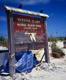
- Hawaiian Islands National Wildlife Refuge
- National Register of Historic Places listings in Hawaii § Northwestern Hawaiian Islands
- Desert island
- List of islands
Notes
- "Papahānaumokuākea Marine National Monument". www.papahanaumokuakea.gov. Retrieved 2019-12-15.
- Rauzon, 100
- Rand McNally World Atlas Pictorial Edition. Chicago: Rand McNally & Company. 1934. p. 57.
- Gleason, Kelly. "A Sounding Lead on a Distant Reef, Captain Pollard’s Lessons Learned", Nantucket Historical Association
- Murphy, Robert Cushman (1951). "Birds collected during the Whitney South Sea Expedition 59: The populations of the Wedge-tailed Shearwater (Puffinus pacificus)." American Museum Novitates 1512: 1–21. PDF fulltext
- Charles A. Ely, A. Binion Amerson, Jr. (October 1, 1970). "New light on Snow's Krusenstern Island." The Auk 87:800–804.
- Clague, D.A. and Dalrymple, G.B. (1989) Tectonics, geochronology, and origin of the Hawaiian-Emperor Chain in Winterer, E.L. et al. (editors) (1989) The Eastern Pacific Ocean and Hawaii, Boulder, Geological Society of America.
- Rauzon, 3
- Rauzon, 4
- "Papahānaumokuākea Marine National Monument". official web site, National Oceanic and Atmospheric Administration. Archived from the original on 2013-10-11. Retrieved 2009-07-28.
- "Northwestern Hawaiian Islands)". BirdLife Data Zone. BirdLife International. 2020. Retrieved 16 December 2020.
- FWS (2009). "Laysan Duck - Midway Atoll National Wildlife Refuge". U.S. Fish & Wildlife Service.
- Eagle, Nathan (August 26, 2016). "Obama To Create World's Largest Protected Marine Area Off Hawaii". Retrieved August 26, 2016.
- "Fact Sheet: President Obama to Create the World's Largest Marine Protected Area". whitehouse.gov. August 26, 2016. Retrieved September 3, 2016 – via National Archives.
References
- Census Tract 114.98 and Block 1001 (Necker Island), Honolulu County, Hawaii, United States Census Bureau.
- Rauzon, M. (2001). "Isles of Refuge: Wildlife and History of the Northwestern Hawaiian Islands". University of Hawaii Press.
{{cite journal}}: Cite journal requires|journal=(help).
External links
- Interactive Map from the PBS Ocean Adventures site
- Navigating Change
- National Monument NOAA Webpage
- Northwest Hawaiian Islands Multi-Agency Education Project Archived 2010-07-14 at the Wayback Machine
- Papahānaumokuākea Marine National Monument Information Management System
State of Hawaii | |
|---|---|
Honolulu (capital) | |
| Topics |
|
| Society |
|
| Main islands | |
| Northwestern Islands | |
| Communities | |
| Counties | |
| Sovereignty Movement |
|
Authority control | |
|---|---|
| General | |
| National libraries | |
На других языках
[de] Nordwestliche Hawaii-Inseln
Die Nordwestlichen Hawaii-Inseln oder Inseln unter dem Winde (abgekürzt NWHI, englisch Northwestern Hawaiʻian Islands oder Leeward Islands, hawaiisch Papahānaumokuākea) sind eine Kette kleiner Inseln, Atolle und Korallenriffe im zentralen Pazifischen Ozean.- [en] Northwestern Hawaiian Islands
[es] Islas de Sotavento (Hawái)
Las islas de Sotavento de Hawái (en inglés: Northwestern Hawaiian Islands o Leeward Islands) son las islas, atolones, arrecifes y bancos de arena del archipiélago de Hawái situadas al noroeste de las islas de Kauai y Niihau.[fr] Îles hawaïennes du Nord-Ouest
Les îles hawaïennes du Nord-Ouest ou îles hawaïennes sous le vent, en anglais Northwestern Hawaiian Islands et Leeward Islands sont un ensemble de petites îles et atolls de l'archipel d'Hawaï située au nord-ouest des îles de Kauai et Niihau. Elles font partie de l'État américain d'Hawaï à l'exception des îles Midway administrées par l'United States Fish and Wildlife Service. Elles sont rattachées au Comté d'Honolulu et forme le Monument national marin de Papahānaumokuākea. Leur superficie totale est d'environ 8 km2.[it] Isole Hawaii nordoccidentali
Le Isole Hawaii nordoccidentali o Isole Leeward sono un insieme di piccole isole e atolli della Catena Insulare Hawaiiana situate a nordovest (in alcuni casi anche molto lontano) delle Isole Kauai e Niihau. Sono amministrate dallo Stato americano delle Hawaii fatta eccezione per l'Atollo di Midway, che ha strutture residenziali temporanee ed è amministrato dallo United States Fish and Wildlife Service. Nello Stato delle Hawaii, fanno parte della Contea di Honolulu. Lo United States Census Bureau definisce quest'area come Zona di Censimento 114.98 della Contea di Honolulu. La sua superficie terrestre totale è di 8,0485 Km².[ru] Подветренные Гавайские острова
Северо-западные Гавайские острова или Подветренные острова (англ. Northwestern Hawaiian Islands) — маленькие острова и атоллы в гряде Гавайских островов расположенные на северо-западе (в некоторых случаях, далеко на северо-западе) от островов Кауаи и Ниихау. Они находятся в ведении американского штата Гавайи, за исключением атолла Мидуэй, имеющего временные жилые помещения и находящегося в ведении Службы рыбных ресурсов и дикой природы США. Острова являются частью округа Гонолулу штата Гавайи. Общая площадь земель островов составляет 14,3 км² (8,0485 км² (3,1075 кв миль) без острова Мидуэй (6,23 км²)).Другой контент может иметь иную лицензию. Перед использованием материалов сайта WikiSort.org внимательно изучите правила лицензирования конкретных элементов наполнения сайта.
WikiSort.org - проект по пересортировке и дополнению контента Википедии