geo.wikisort.org - Island
The Hawaiian Islands (Hawaiian: Mokupuni o Hawai‘i) are an archipelago of eight major islands, several atolls, and numerous smaller islets in the North Pacific Ocean, extending some 1,500 miles (2,400 kilometers) from the island of Hawaiʻi in the south to northernmost Kure Atoll. Formerly the group was known to Europeans and Americans as the Sandwich Islands, a name that James Cook chose in honor of the 4th Earl of Sandwich, the then First Lord of the Admiralty. Cook came across the islands by chance when crossing the Pacific Ocean on his Third Voyage, on board HMS Resolution; he was later killed on the islands on a return visit. The contemporary name of the islands, dating from the 1840s, is derived from the name of the largest island, Hawaiʻi Island.
This article needs additional citations for verification. (January 2021) |
Native name: Mokupuni o Hawai‘i | |
|---|---|
 The Windward Islands of Hawaii | |
 | |
| Geography | |
| Location | North Pacific Ocean |
| Coordinates | 20°54′00″N 156°36′00″W |
| Total islands | 137 |
| Highest point |
|
| Administration | |
United States | |
| State | Hawaii |
| Unincorporated territory | Midway Atoll |
| Largest settlement | Honolulu |
Hawaii sits on the Pacific Plate and is the only U.S. state that is not geographically connected to North America. It is part of the Polynesia subregion of Oceania. The state of Hawaii occupies the archipelago almost in its entirety (including the mostly uninhabited Northwestern Hawaiian Islands), with the sole exception of Midway Island, which also belongs to the United States, albeit as one of its unincorporated territories within the United States Minor Outlying Islands.
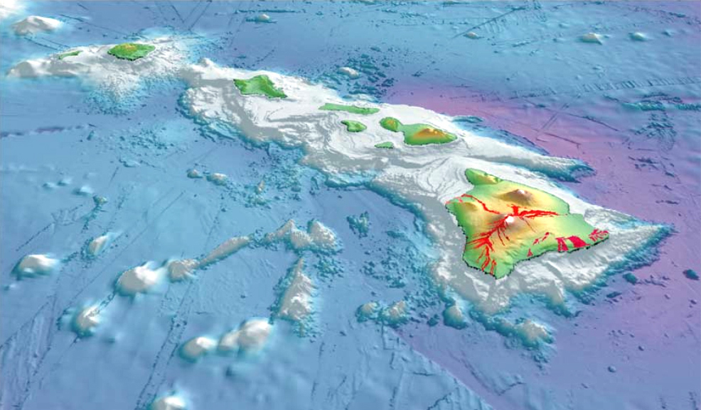
The Hawaiian Islands are the exposed peaks of a great undersea mountain range known as the Hawaiian–Emperor seamount chain, formed by volcanic activity over a hotspot in the Earth's mantle. The islands are about 1,860 miles (3,000 km) from the nearest continent.
Islands and reefs
The date of the first settlements of the Hawaiian Islands is a topic of continuing debate.[1] Archaeological evidence seems to indicate a settlement as early as 124 AD.[2]
Captain James Cook, RN, visited the islands on January 18, 1778,[3] and named them the "Sandwich Islands" in honor of The 4th Earl of Sandwich, who as the First Lord of the Admiralty was one of his sponsors.[4] This name was in use until the 1840s, when the local name "Hawaii" gradually began to take precedence.[5]
The Hawaiian Islands have a total land area of 6,423.4 square miles (16,636.5 km2). Except for Midway, which is an unincorporated territory of the United States, these islands and islets are administered as Hawaii—the 50th state of the United States.[6]
Major islands
| Island | Nickname | Area | Population (as of 2020) |
Density | Highest point | Elevation | Age (Ma)[7] | Location |
|---|---|---|---|---|---|---|---|---|
| Hawaiʻi[8] | The Big Island | 4,028.0 sq mi (10,432.5 km2) | 200,629 | 45.948/sq mi (17.7407/km2) | Mauna Kea | 13,796 ft (4,205 m) | 0.4 | 19°34′N 155°30′W |
| Maui[9] | The Valley Isle | 727.2 sq mi (1,883.4 km2) | 164,221 | 198.630/sq mi (76.692/km2) | Haleakalā | 10,023 ft (3,055 m) | 1.3–0.8 | 20°48′N 156°20′W |
| Oʻahu[10] | The Gathering Place | 596.7 sq mi (1,545.4 km2) | 1,016,508 | 1,597.46/sq mi (616.78/km2) | Mount Kaʻala | 4,003 ft (1,220 m) | 3.7–2.6 | 21°28′N 157°59′W |
| Kauaʻi[11] | The Garden Isle | 552.3 sq mi (1,430.5 km2) | 73,298 | 121.168/sq mi (46.783/km2) | Kawaikini | 5,243 ft (1,598 m) | 5.1 | 22°05′N 159°30′W |
| Molokaʻi[12] | The Friendly Isle | 260.0 sq mi (673.4 km2) | 7,345 | 28.250/sq mi (10.9074/km2) | Kamakou | 4,961 ft (1,512 m) | 1.9–1.8 | 21°08′N 157°02′W |
| Lānaʻi[13] | The Pineapple Isle | 140.5 sq mi (363.9 km2) | 3,367 | 22.313/sq mi (8.615/km2) | Lānaʻihale | 3,366 ft (1,026 m) | 1.3 | 20°50′N 156°56′W |
| Niʻihau[14] | The Forbidden Isle | 69.5 sq mi (180.0 km2) | 84 | 2.45/sq mi (0.944/km2) | Mount Pānīʻau | 1,250 ft (381 m) | 4.9 | 21°54′N 160°10′W |
| Kahoʻolawe[15] | The Target Isle | 44.6 sq mi (115.5 km2) | 0 | 0/sq mi (0/km2) | Puʻu Moaulanui | 1,483 ft (452 m) | 1.0 | 20°33′N 156°36′W |
The eight major islands of Hawaii (Windward Islands) are listed above. All except Kaho'olawe are inhabited.[16]
Minor islands, islets
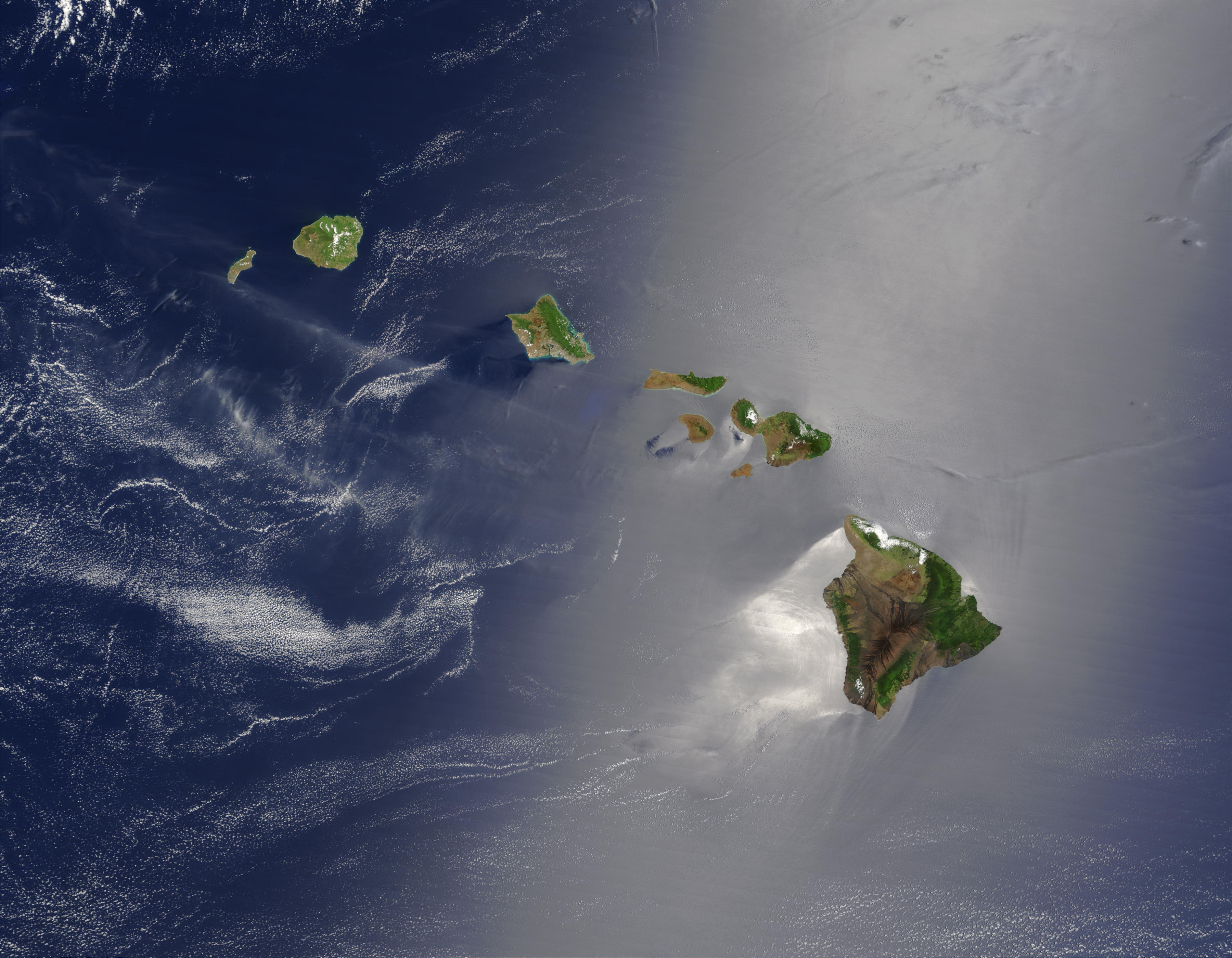
![Hawaiian Islands from space.[17]](http://upload.wikimedia.org/wikipedia/commons/1/1b/ISS-38_Hawaiian_Island_chain.jpg)
The state of Hawaii counts 137 "islands" in the Hawaiian chain.[18] This number includes all minor islands (small islands), islets (even smaller islands) offshore of the major islands (listed above) and individual islets in each atoll. These are just a few:
- Kaʻula
- Kāohikaipu
- Lehua
- Mānana
- Mōkōlea Rock
- Mokoliʻi
- Moku Manu
- Mokuauia
- Moku o Loʻe
- Moku Ola
- Mokuʻumeʻume
- Molokini
- Nā Mokulua
Partial islands, atolls, reefs

Partial islands, atolls, reefs (west of Niʻihau are uninhabited except Midway Atoll) form the Northwestern Hawaiian Islands (Leeward Islands):
- Nihoa (Mokumana)
- Necker (Mokumanamana)
- French Frigate Shoals (Kānemilohaʻi)
- Gardner Pinnacles (Pūhāhonu)
- Maro Reef (Nalukākala)
- Laysan (Kauō)
- Lisianski Island (Papaʻāpoho)
- Pearl and Hermes Atoll (Holoikauaua)
- Midway Atoll (Pihemanu)
- Kure Atoll (Mokupāpapa)
Geology
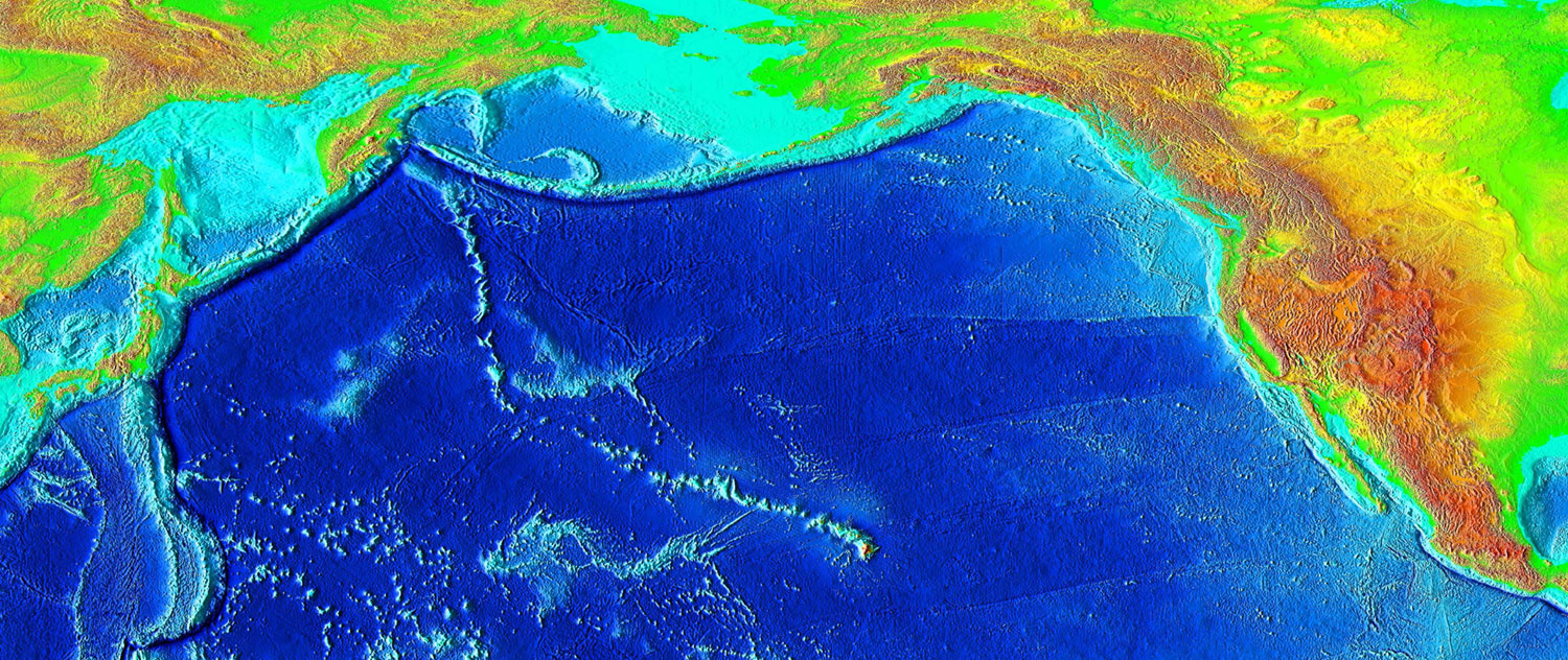
This chain of islands, or archipelago, developed as the Pacific Plate slowly moved northwestward over a hotspot in the Earth's mantle at a rate of approximately 32 miles (51 km) per million years. Thus, the southeast island is volcanically active, whereas the islands on the northwest end of the archipelago are older and typically smaller, due to longer exposure to erosion. The age of the archipelago has been estimated using potassium-argon dating methods.[19] From this study and others,[20][21] it is estimated that the northwesternmost island, Kure Atoll, is the oldest at approximately 28 million years (Ma); while the southeasternmost island, Hawaiʻi, is approximately 0.4 Ma (400,000 years). The only active volcanism in the last 200 years has been on the southeastern island, Hawaiʻi, and on the submerged but growing volcano to the extreme southeast, Kamaʻehuakanaloa (formerly Loʻihi). The Hawaiian Volcano Observatory of the USGS documents recent volcanic activity and provides images and interpretations of the volcanism. Kīlauea had been erupting nearly continuously since 1983 when it stopped August 2018.
Almost all of the magma of the hotspot has the composition of basalt, and so the Hawaiian volcanoes are composed almost entirely of this igneous rock. There is very little coarser-grained gabbro and diabase. Nephelinite is exposed on the islands but is extremely rare. The majority of eruptions in Hawaiʻi are Hawaiian-type eruptions because basaltic magma is relatively fluid compared with magmas typically involved in more explosive eruptions, such as the andesitic magmas that produce some of the spectacular and dangerous eruptions around the margins of the Pacific basin.
Hawaiʻi island (the Big Island) is the biggest and youngest island in the chain, built from five volcanoes. Mauna Loa, taking up over half of the Big Island, is the largest shield volcano on the Earth. The measurement from sea level to summit is more than 2.5 miles (4 km), from sea level to sea floor about 3.1 miles (5 km).[22]
Earthquakes
The Hawaiian Islands have many earthquakes, generally caused by volcanic activity. Most of the early earthquake monitoring took place in Hilo, by missionaries Titus Coan, Sarah J. Lyman and her family. Between 1833 and 1896, approximately 4 or 5 earthquakes were reported per year.[23]
Hawaii accounted for 7.3% of the United States' reported earthquakes with a magnitude 3.5 or greater from 1974 to 2003, with a total 1533 earthquakes. Hawaii ranked as the state with the third most earthquakes over this time period, after Alaska and California.[24]
On October 15, 2006, there was an earthquake with a magnitude of 6.7 off the northwest coast of the island of Hawaii, near the Kona area of the big island. The initial earthquake was followed approximately five minutes later by a magnitude 5.7 aftershock. Minor-to-moderate damage was reported on most of the Big Island. Several major roadways became impassable from rock slides, and effects were felt as far away as Honolulu, Oahu, nearly 150 miles (240 km) from the epicenter. Power outages lasted for several hours to days. Several water mains ruptured. No deaths or life-threatening injuries were reported.
On May 4, 2018, there was a 6.9 earthquake in the zone of volcanic activity from Kīlauea.
Earthquakes are monitored by the Hawaiian Volcano Observatory run by the USGS.
Tsunamis

The Hawaiian Islands are subject to tsunamis, great waves that strike the shore. Tsunamis are most often caused by earthquakes somewhere in the Pacific. The waves produced by the earthquakes travel at speeds of 400–500 miles per hour (600–800 km/h) and can affect coastal regions thousands of miles (kilometers) away.
Tsunamis may also originate from the Hawaiian Islands. Explosive volcanic activity can cause tsunamis. The island of Molokaʻi had a catastrophic collapse or debris avalanche over a million years ago; this underwater landslide likely caused tsunamis. The Hilina Slump on the island of Hawaiʻi is another potential place for a large landslide and resulting tsunami.
The city of Hilo on the Big Island has been most affected by tsunamis, where the in-rushing water is accentuated by the shape of Hilo Bay. Coastal cities have tsunami warning sirens.
A tsunami resulting from an earthquake in Chile hit the islands on February 27, 2010. It was relatively minor, but local emergency management officials utilized the latest technology and ordered evacuations in preparation for a possible major event. The Governor declared it a "good drill" for the next major event.
A tsunami resulting from an earthquake in Japan hit the islands on March 11, 2011. It was relatively minor, but local officials ordered evacuations in preparation for a possible major event. The tsunami caused about $30.1 million in damages.[25]
History
This section needs expansion. You can help by adding to it. (September 2021) |
The islands of Hawaii were first settled by explorers, believed to be from the mythical Polynesian civilization of Hawaiki, sometime between 400 AD and 1120 AD.[26]
Ecology
The islands are home to a multitude of endemic species. Since human settlement, first by Polynesians, non native trees, plants, and animals were introduced. These included species such as rats and pigs, that have preyed on native birds and invertebrates that initially evolved in the absence of such predators. The growing population of humans has also led to deforestation, forest degradation, treeless grasslands, and environmental degradation. As a result, many species which depended on forest habitats and food became extinct—with many current species facing extinction. As humans cleared land for farming, monocultural crop production replaced multi-species systems.[citation needed]
The arrival of the Europeans had a more significant impact, with the promotion of large-scale single-species export agriculture and livestock grazing. This led to increased clearing of forests, and the development of towns, adding many more species to the list of extinct animals of the Hawaiian Islands. As of 2009[update], many of the remaining endemic species are considered endangered.[27]
National Monument
On June 15, 2006, President George W. Bush issued a public proclamation creating Papahānaumokuākea Marine National Monument under the Antiquities Act of 1906. The Monument encompasses the northwestern Hawaiian Islands and surrounding waters, forming the largest[28] marine wildlife reserve in the world. In August 2010, UNESCO's World Heritage Committee added Papahānaumokuākea to its list of World Heritage Sites.[29][30][31] On August 26, 2016, President Barack Obama greatly expanded Papahānaumokuākea, quadrupling it from its original size.[32][33][34]
Climate
The Hawaiian Islands are tropical but experience many different climates, depending on altitude and surroundings.[35] The islands receive most rainfall from the trade winds on their north and east flanks (the windward side) as a result of orographic precipitation.[35] Coastal areas in general and especially the south and west flanks, or leeward sides, tend to be drier.[35]
In general, the lowlands of Hawaiian Islands receive most of their precipitation during the winter months (October to April).[35] Drier conditions generally prevail from May to September.[35] The tropical storms, and occasional hurricanes, tend to occur from July through November.[35]
During the summer months the average temperature is about 84 °F (29 °C), in the winter months it is approximately 78,8 °F (26 °C). As the temperature is relatively constant over the year the probability of dangerous thunderstorms is approximately low.[36]
See also
- Hawaii Inter-Island Cable System
- Index of Hawaii-related articles
- List of birds of Hawaii
- List of fish of Hawaii
- List of mountain peaks of Hawaii
- List of Ultras of Hawaii
- Maritime fur trade
- Outline of Hawaii
References
- Pearce, Charles E.M.; Pearce, F. M. (2010). Oceanic Migration: Paths, Sequence, Timing and Range of Prehistoric Migration in the Pacific and Indian Oceans. Springer Science & Business Media. p. 167. ISBN 978-90-481-3826-5.
- Whittaker, Elvi W. (1986). The Mainland Haole: The White Experience in Hawaii. Columbia University Press. p. 3. ISBN 978-0-231-05316-7.
- Rayson, Ann; Bauer, Helen (1997). Hawaii: The Pacific State. Bess Press. p. 26. ISBN 1573060968.
- James Cook and James King (1784). A Voyage to the Pacific Ocean: Undertaken, by the Command of His Majesty, for Making Discoveries in the Northern Hemisphere, to Determine the Position and Extent of the West Side of North America, Its Distance from Asia, and the Practicability of a Northern Passage to Europe: Performed Under the Direction of Captains Cook, Clerke, and Gore, in His Majesty's Ships the Resolution and Discovery, in the Years 1776, 1777, 1778, 1779, and 1780. Vol. 2. Nicol and Cadell, London. p. 222.
- Clement, Russell. "From Cook to the 1840 Constitution: The Name Change from Sandwich to Hawaiian Islands" (PDF). University of Hawai'i at Manoa Hamilton Library. Retrieved June 17, 2012.
- "Guide to State and Local Census Geography – Hawaii" (PDF). Washington, DC: U.S. Census Bureau. September 9, 2013. pp. 1–2. Retrieved September 16, 2016.
- Blay, Chuck, and Siemers, Robert. Kauai‘’s Geologic History: A Simplified Guide. Kaua‘i: TEOK Investigations, 2004. ISBN 9780974472300. (Cited in "Hawaiian Encyclopedia : The Islands". Retrieved June 20, 2012.)
- U.S. Geological Survey Geographic Names Information System: Island of Hawaiʻi
- U.S. Geological Survey Geographic Names Information System: Maui Island
- U.S. Geological Survey Geographic Names Information System: Oʻahu Island
- U.S. Geological Survey Geographic Names Information System: Kauaʻi Island
- U.S. Geological Survey Geographic Names Information System: Molokaʻi Island
- U.S. Geological Survey Geographic Names Information System: Lānaʻi Island
- U.S. Geological Survey Geographic Names Information System: Niʻihau Island
- U.S. Geological Survey Geographic Names Information System: Kahoʻolawe Island
- "Hawaii Population 2016 (Demographics, Maps, Graphs)". worldpopulationreview.com. Retrieved September 12, 2016.
- "Hawaii : Image of the Day". nasa.gov. January 29, 2014. Retrieved June 4, 2015.
- "Hawai'i Facts & Figures" (PDF). state web site. State of Hawaii Dept. of Business, Economic Development & Tourism. December 2009. Archived from the original (PDF) on October 22, 2008. Retrieved May 23, 2010.
- "Tectonics, geochronology, and origin of the Hawaiian-Emperor Volcanic Chain" (PDF). The Geology of North America, Volume N: The Eastern Pacific Ocean and Hawaii. The Geology Society of America. 1989. Archived from the original (PDF) on June 11, 2011. Retrieved January 17, 2011.
- McDougall, IAN; Swanson, D. A. (1972). "Potassium-Argon Ages of Lavas from the Hawi and Pololu Volcanic Series, Kohala Volcano, Hawaii". Geological Society of America Bulletin. Geology Society of American Bulletin. 83 (12): 3731–3738. Bibcode:1972GSAB...83.3731M. doi:10.1130/0016-7606(1972)83[3731:PAOLFT]2.0.CO;2. Retrieved January 17, 2011.
- Clague, David A.; Dalrymple, G. Brent; Moberly, Ralph (1975). "Petrography and K-Ar Ages of Dredged Volcanic Rocks from the Western Hawaiian Ridge and the Southern Emperor Seamount Chain". Geological Society of America Bulletin. Geology Society of America Bulletin. 86 (7): 991–998. Bibcode:1975GSAB...86..991C. doi:10.1130/0016-7606(1975)86<991:PAKAOD>2.0.CO;2. ISSN 0016-7606. Retrieved January 17, 2011.
- "Mauna Loa Earth's Largest Volcano". Hawaiian Volcano Observatory web site. USGS. February 2006. Archived from the original on November 17, 2014. Retrieved December 9, 2009.
- "Hawaii Earthquake History". Earthquake Hazards Program. United States Geological Survey. 1972. Archived from the original on April 19, 2009. Retrieved December 9, 2009.
- "Top Earthquake States". Earthquake Hazards Program. United States Geological Survey. 2003. Archived from the original on August 31, 2009. Retrieved December 9, 2009.
- Trusdell, Frank A.; Chadderton, Amy; Hinchliffe, Graham; Hara, Andrew; Patenge, Brent; Weber, Tom (November 15, 2012). "Tohoku-Oki Earthquake Tsunami Runup and Inundation Data for Sites Around the Island of Hawai'i" (PDF). USGS. pp. 3–4. Retrieved October 11, 2016.
- Smith, Philippa Mein (December 1, 2011). A Concise History of New Zealand (2nd ed.). Cambridge University Press. pp. 6–9. ISBN 9781107402171.
- Craig R. Elevitch; Kim M. Wilkinson, eds. (2000). Agroforestry Guides for Pacific Islands. Permanent Agriculture Resources. ISBN 0-9702544-0-7. Archived from the original on January 12, 2006. Retrieved September 26, 2005.
- Barnett, Cynthia (August 26, 2016). "Hawaii Is Now Home to an Ocean Reserve Twice the Size of Texas". National Geographic. Retrieved September 2, 2016.
- "21 sites added to Unesco World Heritage list – Wikinews, the free news source". Wikinews. August 5, 2010. Retrieved March 28, 2017.
- Saltzstein, Dan (August 4, 2010). "Unesco Adds 21 Sites to World Heritage List". The New York Times. Retrieved March 28, 2017.
- "World Heritage Committee inscribes a total of 21 new sites on UNESCO World Heritage List". whc.unesco.org. August 2, 2010. Retrieved March 28, 2017.
- Cocke, Sophie (August 25, 2016). "Obama expands Papahanaumokuakea marine reserve; plans Oahu trip". Honolulu Star Advertiser. Retrieved March 28, 2017.
- "Fact Sheet: President Obama to Create the World's Largest Marine Protected Area". whitehouse.gov. August 26, 2016. Retrieved March 28, 2017.
- Barnett, Cynthia (August 26, 2016). "Hawaii Is Now Home to an Ocean Reserve Twice the Size of Texas". NationalGeographic.com. Retrieved March 28, 2017.
- Lau, Leung-Ku Stephen; Mink, John Francis (October 1, 2006). Hydrology of the Hawaiian Islands. pp. 39, 43, 49, 53. ISBN 9780824829483.
- "So ist das Wetter auf Hawaii". Hawaiiurlaub.de (in German). July 24, 2015. Retrieved June 24, 2020.
Further reading
- Morgan, Joseph R. (1996). "Volcanic Landforms". Hawai'i: A Unique Geography. Honolulu, HI: Bess Press. ISBN 9781573060219. OCLC 693187693 – via Internet Archive.
- An integrated information website focused on the Hawaiian Archipelago from the Pacific Region Integrated Data Enterprise (PRIDE).
- Macdonald, Gordon A.; Abbott, Agatin (2021) [1970]. Volcanoes in the Sea: The Geology of Hawaii. Honolulu: University of Hawaii Press. doi:10.1515/9780824885786. ISBN 9780824885786. OCLC 1253313940.
- 1970 edition: Volcanoes in the Sea: The Geology of Hawaii at the Internet Archive (registration required)
- The Ocean Atlas of Hawai‘i Archived April 7, 2022, at the Wayback Machine – SOEST at University of Hawaiʻi.
- "Hawaiian Volcanoes – Introduction – Department of Geosciences". Corvallis, OR, USA. Archived from the original on March 5, 2012. Retrieved May 12, 2012. Volcano World |; Your World is Erupting – Oregon State University College of Science
State of Hawaii | |
|---|---|
Honolulu (capital) | |
| Topics |
|
| Society |
|
| Main islands | |
| Northwestern Islands | |
| Communities | |
| Counties | |
| Sovereignty Movement |
|
| Authority control: National libraries |
|---|
На других языках
[de] Liste der Hawaii-Inseln
Die Hawaii-Inselkette besteht aus acht großen Hauptinseln im Südosten des Archipels, im Englischen auch als Southeastern oder Windward Islands bezeichnet, denen zahlreiche „Satelliteninseln“ (engl. Offshore Islets) vorgelagert sind. Nordwestlich der Hauptinseln liegen unbewohnte Inseln und Atolle, die sogenannten Nordwestlichen Hawaii-Inseln (engl. Northwestern Hawaiʻian Islands oder Leeward Islands). Mit Ausnahme der Midwayinseln gehören alle Inseln politisch zum US-Bundesstaat Hawaii.- [en] Hawaiian Islands
[es] Archipiélago de Hawái
El archipiélago de Hawái (en inglés, Hawaiian Islands), antes conocidas como islas Sandwich (no confundir con las islas Sandwich del Sur), está formado por nueve islas y atolones, además de islotes, arrecifes y bancos de arena, en una alineación del noroeste al sureste a lo largo de 2450 km en el Pacífico Norte. El archipiélago toma el nombre de la isla más grande, Hawái, que a la vez es la más oriental.[it] Isole delle Hawaii
Le isole delle Hawaii , o isole avajane in italiano arcaico[1], costituiscono un arcipelago di otto isole grandi, numerosi atolli e numerosi piccoli isolotti, nonché montagne sottomarine nel nord dell'oceano Pacifico. Esse si estendono per circa 2400 km dall'isola di Hawaii (estremità sud) all'atollo di Kure (estremità nord).[ru] Гавайские острова
Гава́йские острова́ (или Гавайский архипелаг, англ. Hawaiian Islands, гав. mokupuni o Hawaiʻi) — архипелаг из 24 островов и атоллов, расположенный в северной части Тихого океана (между 19° и 29° северной широты). Архипелаг вытянут с северо-запада на юго-восток, имеет вулканическое происхождение, как и фиджийские.Другой контент может иметь иную лицензию. Перед использованием материалов сайта WikiSort.org внимательно изучите правила лицензирования конкретных элементов наполнения сайта.
WikiSort.org - проект по пересортировке и дополнению контента Википедии