geo.wikisort.org - Island
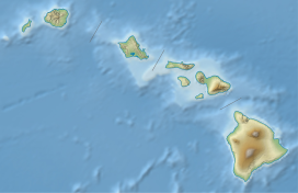
Mānana Island is an uninhabited islet located 0.75 mi (1.21 km) off Kaupō Beach, near Makapuʻu at the eastern end of the island of Oʻahu in the Hawaiian Islands. In the Hawaiian language, mānana means "buoyant".[1] The islet is commonly referred to as Rabbit Island, because its shape as seen from the nearby Oʻahu shore looks something like a rabbit's head and because it was once inhabited by introduced rabbits. The rabbit colony was established by John Adams Cummins in the 1880s when he ran the nearby Waimānalo plantation.[2] The rabbits were eradicated about a hundred years later because they were destroying the native ecosystem, an important seabird breeding area.
| Mānana | |
|---|---|
 Mānana Island (and Kāohikaipu) as seen from Oahu | |
| Highest point | |
| Elevation | 110 m (360 ft) |
| Prominence | 110 m (360 ft) |
| Coordinates | 21°19′52″N 157°39′32″W |
| Geography | |
| Geology | |
| Mountain type | Tuff cone |
| Last eruption | Less than 200,000 years ago |
Mānana is a tuff cone with two vents or craters. The highest point on the islet rises to 361 ft (110 m). The island is 2,319 ft (707 m) long and 2,147 ft (654 m) wide and has an area of about 63 acres (25 ha). Mānana's only sand beach is a small storm beach on the west to south-west (leeward) side of the islet. This sand deposit, located above the reach of the normal waves, is about 30 ft (9.1 m) wide and curves around to the western side of the island. Another volcanic islet named Kāohikaipu sits right next to Mānana.
Manana was formed by the Honolulu Volcanic Series. These series of eruptions were responsible for creating other tuff cones such as Punchbowl Crater.
Mānana is a State Seabird Sanctuary—home to over 10,000 wedge-tailed shearwaters, 80,000 sooty terns, 20,000 brown noddys, 5–10 Bulwer's petrels, and 10–15 red-tailed tropicbirds, and numerous Hawaiian monk seals. It is illegal to land on the islet without permission from the Hawaiʻi Department of Land and Natural Resources.[3]
References
- John R. K. Clark (2004). "lookup of Mānana ". in Hawai'i Place Names: Shores, Beaches, and Surf Sites. Ulukau, the Hawaiian Electronic Library, University of Hawaii Press. Retrieved November 27, 2010.
- John R. K. Clark (2004). "lookup of Rabbit Island ". in Hawai'i Place Names: Shores, Beaches, and Surf Sites. Ulukau, the Hawaiian Electronic Library, University of Hawaii Press. Retrieved November 27, 2010.
- "Chapter 125: Rules Regulating Wildlife Sanctuaries" (PDF). Hawaiʻi Department of Land and Natural Resources. Archived from the original (PDF) on May 17, 2011. Retrieved November 27, 2010.
External links
 Media related to Mānana at Wikimedia Commons
На других языках
[de] Mānana
Mānana (englisch auch Rabbit Island) ist eine kleine, unbewohnte Insel im Archipel von Hawaii im Pazifik. Sie liegt etwa 1,2 Kilometer von Kaupō Beach entfernt, unweit Makapuʻu Point, der Südostspitze der Insel Oʻahu, und gehört zum Honolulu County.- [en] Mānana
[ru] Манана
Манана (гав. Mānana) — гавайский остров, который находится на западной стороне острова Оаху, приблизительно на расстоянии 1,2 км от пляжа Кайпу, неподалёку от Макапу. Остров в длину 707 м, в ширину — 654 м. На гавайском языке mānana означает «плавучесть».Другой контент может иметь иную лицензию. Перед использованием материалов сайта WikiSort.org внимательно изучите правила лицензирования конкретных элементов наполнения сайта.
WikiSort.org - проект по пересортировке и дополнению контента Википедии

