geo.wikisort.org - Island
Oahu (/oʊˈɑːhuː/) (Hawaiian: Oʻahu (pronounced [oˈʔɐhu])), also known as "The Gathering Place", is the third-largest of the Hawaiian Islands. It is home to roughly one million people—over two-thirds of the population of the U.S. state of Hawaii. The island of O’ahu and the Northwestern Hawaiian Islands constitute the City and County of Honolulu. The state capital, Honolulu, is on Oʻahu's southeast coast. Oʻahu had a population of 1,016,508[1] according to the 2020 U.S. Census, up from 953,207 people in 2010 (approximately 70% of the total 1,455,271 population of the State of Hawaii,[2] with approximately 81% of those living in or near the Honolulu urban area).
Nickname: The Gathering Place | |
|---|---|
 Oblique satellite photo of Oʻahu | |
 | |
| Geography | |
| Location | 21.4730°N 157.9868°W |
| Area | 596.7 sq mi (1,545 km2) |
| Area rank | 3rd largest Hawaiian Island |
| Highest elevation | 4,025 ft (1226.8 m) |
| Highest point | Kaʻala |
| Administration | |
United States | |
| Symbols | |
| Flower | ʻilima |
| Color | Melemele (yellow) |
| Largest settlement | Honolulu |
| Demographics | |
| Population | 1,016,508 (2020) |
| Pop. density | 1,704/sq mi (657.9/km2) |
Name
The Island of Oʻahu in Hawaii is often nicknamed (or translated as) "The Gathering Place". It appears that Oʻahu grew into this nickname; it is currently the most populated Hawaiian Island, however, in ancient times, Oʻahu was not populous and was outranked by the status of other islands. The translation of "gathering place" was suggested as recently as 1922 by Hawaiian Almanac author Thomas Thrum. It has been speculated[by whom?] that Thrum ignored or misplaced the ʻokina because the Hawaiian phrase "ʻo ahu" could be translated as "gathering of objects" (ʻo is a subject marker and ahu means "to gather"). The term Oʻahu has no confirmed meaning in Hawaiian, other than that of the place itself.[3][4]
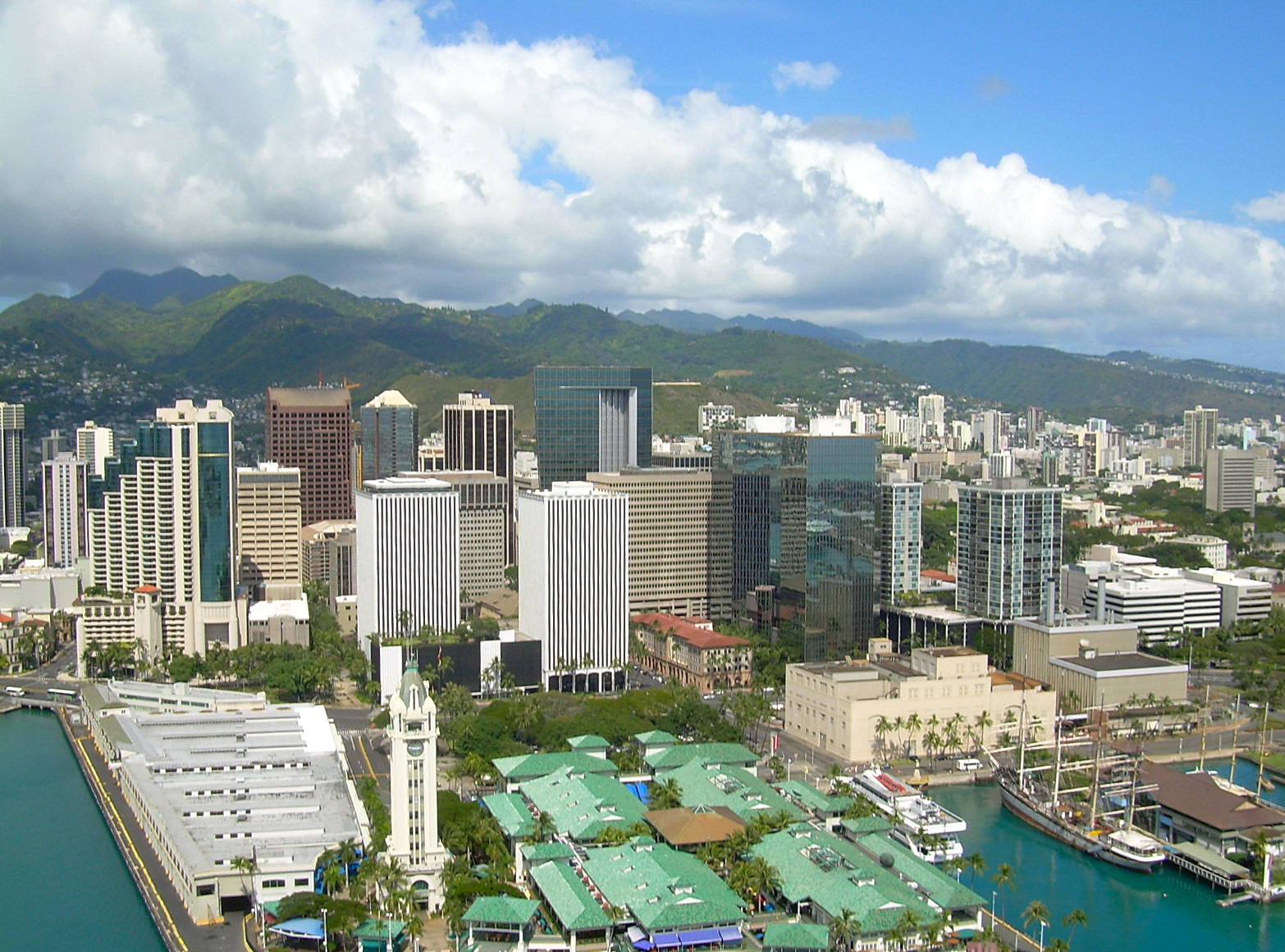
The city of Honolulu—largest city, state capital, and main deepwater marine port for the State of Hawaiʻi—is located here. As a jurisdictional unit, the entire island of Oʻahu is in Honolulu County, although as a place name, Honolulu occupies only a portion of the southeast end of the island.
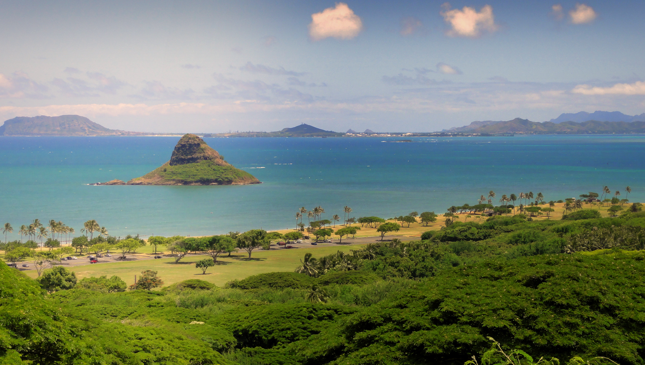
Well-known features found on Oʻahu include Waikiki, Pearl Harbor, Diamond Head, Hanauma, Kāneʻohe Bay, Kailua Bay, North Shore, and the resort destination, Ko Olina.
While the island is designated the City and County of Honolulu, excluding the minor Northwestern Hawaiian Islands, residents identify settlements using town names (generally those of the census-designated places), and consider the island to be divided into various areas which may overlap. The most commonly accepted areas are the "City", "Town" or "Town side", which is the urbanized area from Halawa to the area below Diamond Head (residents of the island north of the Koʻolau Mountains consider the Town Side to be the entire southern half), "West Oʻahu", which goes from Pearl Harbor to Kapolei, ʻEwa and may include the Waiʻanae and Mākaha areas; the "North Shore" (northwestern coast); the "Windward Side" (northeastern coast from Kahuku to Kāneʻohe); the "East Side" or "East Coast" (the eastern portion of the island, from Kāneʻohe on the northeast, around the tip of the island to include much of the area east of Diamond Head); and "The Valley" or "Central Oʻahu" which runs northwest from Pearl Harbor toward Haleʻiwa. These terms are somewhat flexible, depending on the area in which the user lives, and are used in a mostly general way, but residents of each area identify strongly with their part of the island, especially those outside of widely-known towns. For instance, if locals are asked where they live, they would usually reply "Windward Side" rather than "Kailua".
History
This section does not cite any sources. (September 2011) |


The island has been inhabited since at least the 3rd century A.D.[5] The 304-year-old Kingdom of Oʻahu was once ruled by the most ancient aliʻi in all of the Hawaiian Islands. The first great king of Oʻahu was Maʻilikūkahi, the lawmaker, who was followed by many generation of monarchs. Kualiʻi was the first of the warlike kings and so were his sons. In 1773, the throne fell upon Kahahana, the son of Elani of Ewa. In 1783, Kahekili II, King of Maui, conquered Oʻahu and deposed the reigning family and then made his son, Kalanikūpule, king of O'ahu, turning O'ahu into a puppet state. Kamehameha the Great would conquer in the mountain Kalanikūpule's force in the Battle of Nuʻuanu. Kamehameha founded the Kingdom of Hawaiʻi with the conquest of Oʻahu in 1795. Hawaiʻi would not be unified until the islands of Kauaʻi and Niʻihau surrendered under King Kaumualiʻi in 1810. Kamehameha III moved his capital from Lāhainā, Maui to Honolulu, Oʻahu in 1845. ʻIolani Palace, built later by other members of the royal family, is still standing, and is the only royal palace on American soil.
Oʻahu was apparently the first of the Hawaiian Islands sighted by the crew of HMS Resolution on January 19, 1778, during Captain James Cook's third Pacific expedition. Escorted by HMS Discovery, the expedition was surprised to find high islands this far north in the central Pacific. Oʻahu was not actually visited by Europeans until February 28, 1779, when Captain Charles Clerke aboard HMS Resolution stepped ashore at Waimea Bay. Clerke had taken command of the ship after James Cook was killed at Kealakekua Bay (island of Hawaiʻi) on February 14, and was leaving the islands for the North Pacific. With the discovery of the Hawaiian Islands came the introduction of disease, mosquitoes, and aggressive foreign animals. Although indirect, the simple exposure to these foreign species caused permanent damage to the Native Hawaiian people and environment.
The Imperial Japanese Navy's attack on Pearl Harbor, Oʻahu on the morning of December 7, 1941 brought the United States into World War II. The surprise attack was aimed at destroying the American will to fight and make them sue for peace immediately by attacking the Pacific Fleet of the United States Navy and its defending Army Air Forces and Marine Air Forces. The attack damaged or destroyed twelve American warships, destroyed 188 aircraft, and resulted in the deaths of 2,335 American servicemen and 68 civilians (of those, 1,177 were the result of the destruction of the USS Arizona alone).
Today, Oʻahu has become a tourism and shopping haven. Over five million visitors (mainly from the contiguous United States and Japan) flock there every year to enjoy the island.
Climate
| ||||||||||||||||||||||||||||||||||||||||||||||||||||||||||||||||||||||||||||||||||||||||||||||||||||||||||||||||||||||||||||
Oʻahu is also known for having the longest rain shower in history, which lasted for 200 consecutive days. Kāneʻohe Ranch reported 247 straight days with rain from August 27, 1993 to April 30, 1994. The average temperature in Oʻahu is around 70–85 °F (21–29 °C) and the island is the warmest in June through October. The weather during the winter is cooler, but still warm with an average temperature of 68–78 °F (20–26 °C).
Geography
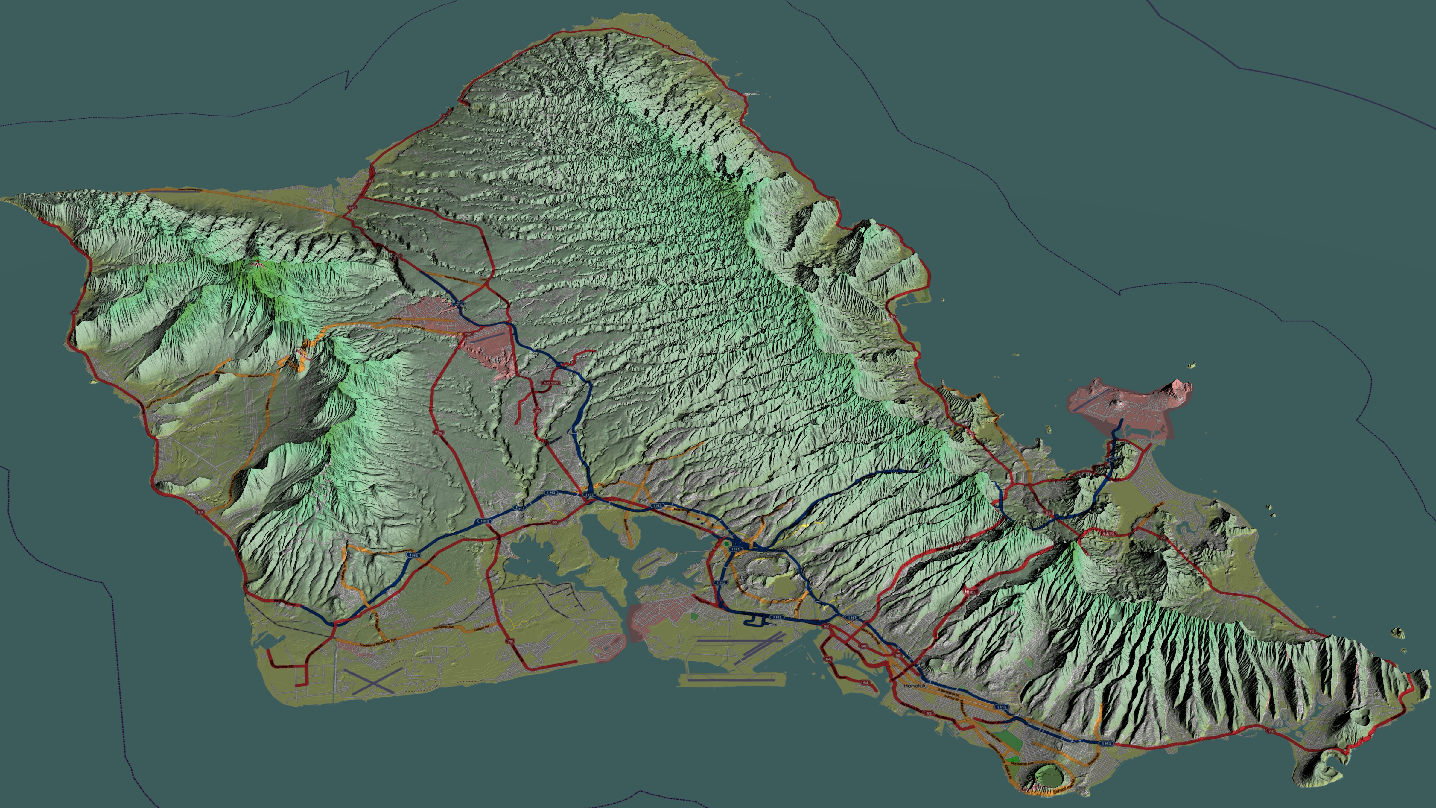
Oʻahu is 44 miles (71 km) long and 30 miles (48 km) across. Its shoreline is 227 miles (365 km) long. Including small associated islands such as Ford Island plus those in Kāneʻohe Bay and off the eastern (windward) coast, its area is 596.7 square miles (1,545.4 km2), making it the 20th-largest island in the United States.[7]The windward side is known for some of the most beautiful beaches in the world. Lanikai Beach on the windward coast of Oʻahu has been consistently ranked among the best beaches in the world.[8] The island is composed of two separate shield volcanoes: the Waiʻanae and Koʻolau Ranges, with a broad valley or saddle (the central Oʻahu Plain) between them. The highest point is Kaʻala in the Waiʻanae Range, rising to 4,003 feet (1,220 m) above sea level.[9]
Being roughly diamond-shaped, surrounded by ocean and divided by mountain ranges, directions on Oʻahu are not generally described with the compass directions found throughout the world. Locals instead use directions originally using Honolulu as the central point. To go ʻewa means traveling toward the western tip of the island, "Diamond Head" is toward the eastern tip, mauka is inland (toward the central Koʻolau Mountain range, north of Honolulu) and makai toward the sea. When these directions became common, Diamond Head was the eastern edge of the primary populated area. Today, with a much larger populace and extensive development, the mountain itself is often not actually to the east when directions are given, and is not to be used as a literal point of reference—to go "Diamond Head" is to go to the east from anywhere on the island.
Tourist attractions


Top beaches
- Ala Moana Beach
- Hanauma Bay
- Kāneʻohe Bay
- Ko Olina Beach Park
- Kailua
- Lanikai Beach
- Papailoa Beach
- Sandy Beach
- Sunset Beach
- Waikīkī Beach
- Waimānalo Beach
- Waimea Bay
Attractions
- Ala Moana
- Aloha Tower
- Aulani, a Disney Resort & Spa
- Banzai Pipeline
- Bishop Museum
- Diamond Head
- Dole Plantation
- Foster Botanical Garden
- Kaʻena Point
- Honolulu
- Honolulu Museum of Art
- Hoʻomaluhia Botanical Garden
- ʻIolani Palace
- Kualoa Ranch
- Lāʻie Hawaii Temple
- Nuʻuanu Pali Lookout
- Mauna ʻAla
- Makapuu Lighthouse
- National Memorial Cemetery of the Pacific or "Punchbowl"
- North Shore
- Pali Lookout
- Pearl Harbor
- Polynesian Cultural Center
- Triple Crown of Surfing
- USS Arizona Memorial
- USS Missouri
- Valley of the Temples Memorial Park
- Waikīkī
- Waikīkī Aquarium
- Waimea Valley Audubon Center
- Waimea Valley


In popular culture
- In the video games Test Drive Unlimited and Test Drive Unlimited 2 players can drive around O'ahu island's 1,000 miles (1,600 km) of road.[10]
- Microsoft Flight, released in 2012 as the successor to the Microsoft Flight Simulator series, was set on island of Hawaiʻi. The game had a piece of downloadable content (DLC) called Hawaiian Adventure Pack. Once purchased, it brought detail to all of the Hawaiian islands to the game, including Oʻahu. The DLC also brought new airports to land and take off from and new missions to complete, among other things.
- Lost was filmed almost entirely on Oʻahu, with many locations on the island (predominantly Honolulu) serving as a stand-in for other locations (including United States, Australia, United Kingdom, and South Korea). Many of the show's stars still call the island home. The island's thick rainforests and picturesque beaches are prominently featured.
- 50 First Dates, a movie that takes place on the island.
- MythBusters shot their 2012 Season's "Duct Tape Island" episode on this island[11]
- The South Korean reality TV series Father and Me was filmed on Oʻahu in 2016[12]
- The Reimanns, a popular German reality TV series, has been filmed on the North Shore at the family's estate in Pūpūkea since December 2015.[13]
Beginning with a contract with the US Navy in 2001, Ocean Power Technologies began ocean-testing Azura, its wave power generation system at the Marine Corps Base Hawaii (MCBH) at Kāneʻohe Bay. The Oʻahu system was launched under the company's program with the US Navy for ocean testing and demonstration of such systems, including connection to the Oʻahu grid.[14] The prototype can produce 20 kW, a system with 500 kW to 1 MW is planned to be installed at end of 2017.[15]
Oʻahu has 343 MW of rooftop solar power,[16] and potential for 92 MW of wind power.[17][18]
Notable people


- Barack Obama, 44th President of the United States
- Benny Agbayani, professional baseball player
- Keiko Agena, actor
- Gabe Baltazar, clarinet and saxophone player
- Alexandria Boehm, scientist
- Darren Brooks, actor, writer, producer
- Max Holloway, MMA Fighter, Former UFC Featherweight Champion
- Angelique Cabral, actor
- Tia Carrere, actor
- Brian Ching, Major League Soccer
- Dennis Chun, actor (Hawaii Five-0), son of Kam Fong
- Bryan Clay, Olympic decathlete 2008
- Scott Crary, film director and producer
- Auliʻi Cravalho, actor, singer
- Mark Dacascos, actor
- Caitlin Doughty, mortician, author and YouTube personality
- Diana Ewing, actor
- Sid Fernandez, baseball
- Maile Flanagan, actor
- Kam Fong, actor
- Lauren Graham, actor
- Erin Gray, actor
- Brian Grazer, Oscar-winning film and television producer
- Coco Ho, pro surfer
- Don Ho, singer
- Kelly Ann Hu, actor
- Carrie Ann Inaba, dancer, actor, musician
- Daniel Inouye, US Senator, Medal of Honor recipient
- Jack Johnson, musician, folk rock singer-songwriter
- Duke Kahanamoku, pro swimmer, surfer, sheriff
- Samuel Kamakau, historian
- Israel Kamakawiwo'ole, musician
- Maxim Knight, actor
- Olin Kreutz, football player Chicago Bears
- Clyde Kusatsu, actor
- Teri Ann Linn, actor
- Jack Lord, actor
- Marcus Mariota, NFL football player, Atlanta Falcons
- Markiplier (Mark Edward Fischbach), Internet personality, video game commentator
- Bruno Mars, singer-songwriter, record producer, musician
- Julie McCullough, actor
- Zack Merrick, drummer in American rock band All Time Low
- Bette Midler, singer, actor, comedian
- Jason Momoa, actor
- Carissa Moore, pro surfer
- Tahj Mowry, actor
- Don Muraco, professional wrestler
- Jamie O'Brien, surfer
- Ellison Onizuka, NASA astronaut, STS-51-C, STS-51-L, Space Shuttle Challenger disaster
- Noelani Pantastico, ballet dancer
- Janel Parrish, actor, singer
- Kelly Preston, actor
- Maggie Q, actor
- Jonah Ray, actor, comedian, writer
- Makua Rothman (born 1984), world champion surfer
- Anthony Ruivivar, actor
- Jesse Sapolu, retired football player, San Francisco 49ers
- Garret T. Sato, actor
- Amanda Schull, actor
- James Shigeta, actor
- Jake Shimabukuro, ʻukulele player
- Karen Steele, actor
- Don Stroud, actor
- Tua Tagovailoa, NFL football player, Miami Dolphins
- Ronald Takaki, academic, historian, ethnographer and author
- Akebono Tarō, sumo wrestler
- Kristi Tauti, professional figure competitor and fitness model
- Manti Te'o, NFL football player, Los Angeles Chargers
- Paul Theroux, author
- Michelle Wie West, golf LPGA
- Taylor Wily, actor
- Kirby Wright, poet and writer
- Keone Young, actor
See also
- Honolulu Volcanics
- National Register of Historic Places listings in Oʻahu
References
Citations
- "US Census Bureau".
- {{Cite web|title=US Census Bureau|url=https://www.census.gov/quickfacts/fact/table/HI/}
- Pukui, et al., 1976
- Pukui, Mary Kawena (December 1976). Place Names of Hawaii. University of Hawaii Press. ISBN 0-8248-0524-0.
- Van, James (2010). Ancient Sites of Oahu: A Guide to Archaeological Places of Interest. Bishop Museum Pr. Page 5. ISBN 978-1581780956.
- "NASA Earth Observations Data Set Index". NASA. Retrieved January 30, 2016.
- "Table 5.08 – Land Area of Islands: 2000" (PDF). State of Hawaii. 2004. Retrieved July 23, 2007.
- Conners, Valerie. "Top 10 Beaches of Hawaii". Travel Channel. Retrieved December 12, 2016.
- "Table 5.11 – Elevations of Major Summits" (PDF). State of Hawaii. 2004. Retrieved July 23, 2007.
- "Test Drive Unlimited 2 trailer shows pretty sights of Ibiza, Oahu". Neoseeker.
- "MythBusters: Duct Tape Island Aftershow : Video : Discovery Channel". Dsc.discovery.com. March 25, 2012. Archived from the original on July 10, 2012. Retrieved August 6, 2013.
- Father and Me Hawaii Tourism Authority 2016. Retrieved 14 June 2017.
- The Reimanns TV episode guide. Retrieved 14 June 2017.
- "Ocean Power Technologies: Capturing Wave Energy for the U.S. Navy and the Grid" (PDF). Acore.org. American Council on Renewable Energy. Archived from the original (PDF) on September 8, 2015. Retrieved May 18, 2015.
- "Azura connects in Hawaii". reNEWS – Renewable Energy News. Archived from the original on May 15, 2018.
- "Solar Energy". Hawaiian Electric. Retrieved January 9, 2017.
- "High Resolution Wind Resource Maps". Hawaiian Electric. Retrieved January 9, 2017.
- Wind resource
Sources
- Doyle, David W., 2001. Rescue in Paradise: Oahu's Beaches and their Guardians. Island Heritage.
- Macdonald, Gordon A., Agatin T. Abbott, and Frank L. Peterson, 1983. Volcanoes in the Sea. University of Hawaiʻi Press, Honolulu. 517 pp.
- Pukui, M. K., S. H. Elbert, and E. T. Mookini, 1976. Place names of Hawaiʻi. University of Hawaiʻi Press. 289 pp.
External links
Islands, municipalities, and communities of Honolulu County, Hawaii, United States | |||||
|---|---|---|---|---|---|
County seat: Honolulu | |||||
| CDPs |
|  | |||
| Other communities |
| ||||
| Government |
| ||||
| |||||
State of Hawaii | |
|---|---|
Honolulu (capital) | |
| Topics |
|
| Society |
|
| Main islands | |
| Northwestern Islands | |
| Communities | |
| Counties | |
| Sovereignty Movement |
|
Hawaiian volcanism topics (list) | ||
|---|---|---|
| Windward Isles |
| |
| Leeward Isles | ||
| Emperor Seamounts |
| |
| Notable eruptions and vents |
| |
| Topics |
| |
Authority control | |
|---|---|
| General | |
| National libraries | |
| Other | |
На других языках
[de] Oʻahu
Oʻahu (engl. und deutsch oft Oahu)[1] ist eine der acht Hauptinseln des Hawaii-Archipels. Sie wird auch The Gathering Place („Der Sammelpunkt“) genannt. Auf Oʻahu liegt Honolulu, die Hauptstadt des US-Bundesstaates Hawaii, welche sich über einen erheblichen Teil der Insel erstreckt.- [en] Oahu
[es] Oahu
Oahu (en hawaiano Oʻahu) es la isla más poblada de Hawái. La ciudad más grande es Honolulu, la capital del estado. Toda la isla está bajo la administración de la Ciudad y Condado de Honolulú, aunque la ciudad en sí solo ocupa una parte al sureste de la isla. Otros lugares de Oahu con renombre internacional son: Waikiki, Pearl Harbor y Diamond Head.[fr] Oahu
Oahu, en hawaïen Oʻahu, est la troisième île par la taille de l’archipel d'Hawaï et la plus peuplée des îles formant l’État d'Hawaï. Elle se situe à 42 km à l'ouest-nord-ouest de Molokai et à 117 km à l'est-sud-est de Kauai. Elle couvre une superficie de 1 545,34 km2, en incluant l’île de Ford et les îlots de la baie de Kaneohe et de la côte est. Elle a 336 kilomètres de côtes[1].[it] Oahu
L'isola di Oahu (in hawaiiano Oʻahu) è l'isola delle Hawaii su cui si trovano la capitale Honolulu, Pearl Harbor, e più della metà della popolazione dello Stato - circa un milione di abitanti.[ru] Оаху
Оа́ху[1] (гав. Oʻahu) — третий по величине и наиболее населённый остров Гавайского архипелага. На юго-восточном побережье острова расположена столица штата Гавайи, город Гонолулу.Другой контент может иметь иную лицензию. Перед использованием материалов сайта WikiSort.org внимательно изучите правила лицензирования конкретных элементов наполнения сайта.
WikiSort.org - проект по пересортировке и дополнению контента Википедии