geo.wikisort.org - Mountains
The Hawaiian–Emperor seamount chain is a mostly undersea mountain range in the Pacific Ocean that reaches above sea level in Hawaii. It is composed of the Hawaiian ridge, consisting of the islands of the Hawaiian chain northwest to Kure Atoll, and the Emperor Seamounts: together they form a vast underwater mountain region of islands and intervening seamounts, atolls, shallows, banks and reefs along a line trending southeast to northwest beneath the northern Pacific Ocean. The seamount chain, containing over 80 identified undersea volcanoes, stretches about 6,200 km (3,900 mi) from the Aleutian Trench in the far northwest Pacific to the Kamaʻehuakanaloa Seamount (formerly Lōʻihi), the youngest volcano in the chain, which lies about 35 kilometres (22 mi) southeast of the Island of Hawaiʻi.
| Hawaiian-Emperor seamount chain | |
|---|---|
| Hawaiian Islands | |
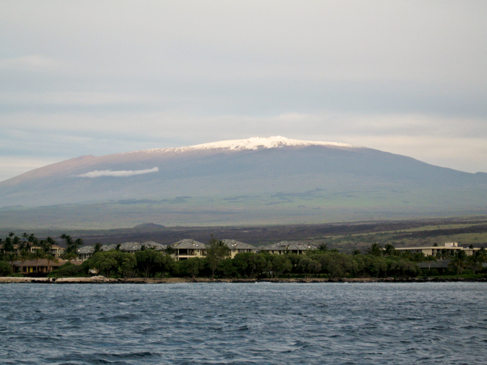 Mauna Kea, the range's highest point | |
| Highest point | |
| Peak | Mauna Kea, Hawaii, United States |
| Elevation | 4,207 m (13,802 ft) |
| Coordinates | 19°49′14″N 155°28′05″W |
| Dimensions | |
| Length | 6,200 km (3,900 mi) NE-SW |
| Geography | |
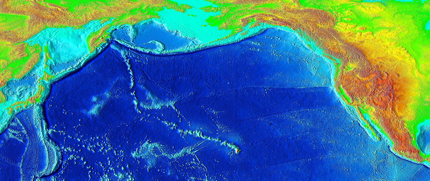 Elevation of the Pacific seafloor, showing the Hawaiian-Emperor seamount chain stretching northwest from the Hawaiian Islands
| |
| Country | United States |
| State | Hawaii |
| Geology | |
| Orogeny | Hawaii hotspot |
Regions
The chain can be divided into three subsections. The first, the Hawaiian archipelago (also known as the Windward isles), consists of the islands comprising the U.S. state of Hawaii. As it is the closest to the hotspot, this volcanically active region is the youngest part of the chain, with ages ranging from 400,000 years[1] to 5.1 million years.[2] The island of Hawaiʻi is composed of five volcanoes, of which four (Kilauea, Mauna Loa, Hualalai, and Mauna Kea) are active. The island of Maui has one active volcano, Haleakalā. Kamaʻehuakanaloa Seamount continues to grow offshore of Hawaiʻi island, and is the only known volcano in the chain in the submarine pre-shield stage.[3]
The second part of the chain is composed of the Northwestern Hawaiian Islands, collectively referred to as the Leeward isles, the constituents of which are between 7.2 and 27.7 million years old.[2] Erosion has long since overtaken volcanic activity at these islands, and most of them are atolls, atoll islands, and extinct islands. They contain many of the most northerly atolls in the world; Kure Atoll, in this group, is the northernmost atoll on Earth.[4] On June 15, 2006, U.S. President George W. Bush issued a proclamation creating Papahānaumokuākea Marine National Monument under the Antiquities Act of 1906. The national monument, meant to protect the biodiversity of the Hawaiian isles,[n 1] encompasses all of the northern isles, and is one of the largest such protected areas in the world. The proclamation limits tourism to the area, and called for a phase-out of fishing by 2011.[5]
The oldest and most heavily eroded part of the chain are the Emperor seamounts, which are 39[6] to 85 million years old.[7] The Emperor and Hawaiian chains form an angle of about 120°. This bend was long attributed to a relatively sudden change of 60° in the direction of plate motion, but research conducted in 2003 suggests that it was the movement of the hotspot itself that caused the bend.[8] The issue is still currently under academic debate.[9] All of the volcanoes in this part of the chain have long since subsided below sea level, becoming seamounts and guyots. Many of the volcanoes are named after former emperors of Japan. The seamount chain extends to the West Pacific, and terminates at the Kuril–Kamchatka Trench, a subduction zone at the border of Russia.[10]
Formation
This section does not cite any sources. (October 2022) |

The oldest conformed age for one of the Emperor Seamounts is 81 million years, for Detroit Seamount. However, Meiji Guyot, located to the north of Detroit Seamount, is likely somewhat older.
In 1963, geologist John Tuzo Wilson hypothesized the origins of the Hawaiian–Emperor seamount chain, explaining that they were created by a hotspot of volcanic activity that was essentially stationary as the Pacific tectonic plate drifted in a northwesterly direction, leaving a trail of increasingly eroded volcanic islands and seamounts in its wake. An otherwise inexplicable kink in the chain marks a shift in the movement of the Pacific plate some 47 million years ago, from a northward to a more northwesterly direction, and the kink has been presented in geology texts as an example of how a tectonic plate can shift direction comparatively suddenly. A look at the USGS map on the origin of the Hawaiian Islands[11] clearly shows this "spearpoint".
In a more recent study, Sharp and Clague (2006) interpret the bend as starting at about 50 million years ago. They also conclude that the bend formed from a "traditional" cause—a change in the direction of motion of the Pacific plate.
However, recent research shows that the hotspot itself may have moved with time. Some evidence comes from analysis of the orientation of the ancient magnetic field preserved by magnetite in ancient lava flows sampled at four seamounts (Tarduno et al., 2003): this evidence from paleomagnetism shows a more complex history than the commonly accepted view of a stationary hotspot. If the hotspot had remained above a fixed mantle plume during the past 80 million years, the latitude as recorded by the orientation of the ancient magnetic field preserved by magnetite (paleolatitude) should be constant for each sample; this should also signify original cooling at the same latitude as the current location of the Hawaiian hotspot. Instead of remaining constant, the paleolatitudes of the Emperor Seamounts show a change from north to south, with decreasing age. The paleomagnetic data from the seamounts of the Emperor chain suggest motion of the Hawaiian hotspot in Earth's mantle. Tarduno et al. (2009) have summarized evidence that the bend in the seamount chain may be caused by circulation patterns in the flowing solid mantle (mantle "wind") rather than a change in plate motion.
Aging
The chain has been produced by the movement of the ocean crust over the Hawaiʻi hotspot, an upwelling of hot rock from the Earth's mantle. As the oceanic crust moves the volcanoes farther away from their source of magma, their eruptions become less frequent and less powerful until they eventually cease altogether. At that point erosion of the volcano and subsidence of the seafloor cause the volcano to gradually diminish. As the volcano sinks and erodes, it first becomes an atoll island and then an atoll. Further subsidence causes the volcano to sink below the sea surface, becoming a seamount and/or a guyot.[3]
See also
- Detroit Seamount
- Isostasy
- Kodiak–Bowie Seamount chain
- Meiji Seamount
- New England Seamounts
- Oceanic trench
- Pacific-Kula Ridge
- Plate tectonics
- Timeline of the far future
Notes
- All of the islands in this part of the chain are administrated by Hawaii state, save for Midway Atoll, which is administrated by the U.S. Fish and Wildlife Service.
References
- Michael O. Garcia, Jackie Caplan-Auerbanch, Eric H. De Carlo, M.D. Kurz, N. Becker (September 20, 2005). "Geology, geochemistry and earthquake history of Lōʻihi Seamount, Hawaiʻi". Chemie der Erde - Geochemistry. This is the pre-press version of a paper that was published on 2006-05-16 as "Geochemistry, and Earthquake History of Lōʻihi Seamount, Hawaiʻi's youngest volcano", in Chemie der Erde – Geochemistry (66) 2:81–108. University of Hawaii – School of Ocean and Earth Science and Technology. 66 (2): 81–108. Bibcode:2006ChEG...66...81G. doi:10.1016/j.chemer.2005.09.002. hdl:1912/1102.
{{cite journal}}: CS1 maint: uses authors parameter (link) Pre-press version - Rubin, Ken. "The Formation of the Hawaiian Islands". Hawaii Center for Vulcanology. Retrieved May 18, 2009.
- "Evolution of Hawaiian Volcanoes". Hawaiian Volcano Observatory (USGS). September 8, 1995. Archived from the original on February 8, 2012. Retrieved March 7, 2009.
- "Kure Atoll". Public Broadcasting System – KQED. March 22, 2006. Retrieved June 13, 2009.
- Staff authors (June 15, 2006). "Bush creates new marine sanctuary". BBC News. Retrieved December 14, 2009.
- Sharp, W. D.; Clague, DA (2006). "50-Ma Initiation of Hawaiian-Emperor Bend Records Major Change in Pacific Plate Motion". Science. 313 (5791): 1281–84. Bibcode:2006Sci...313.1281S. doi:10.1126/science.1128489. PMID 16946069. S2CID 43601673.
- Regelous, M.; Hofmann, A.W.; Abouchami, W.; Galer, S.J.G. (2003). "Geochemistry of Lavas from the Emperor Seamounts, and the Geochemical Evolution of Hawaiian Magmatism from 85 to 42 Ma" (PDF). Journal of Petrology. 44 (1): 113–140. Bibcode:2003JPet...44..113R. doi:10.1093/petrology/44.1.113. Archived from the original (PDF) on July 19, 2011. Retrieved July 23, 2010.
- John Roach (August 14, 2003). "Hot Spot That Spawned Hawaii Was on the Move, Study Finds". National Geographic News. Retrieved March 9, 2009.
- Sharp et al., 2006, Initiation of the bend near Kimmei seamount about 50 million years ago (MA) was coincident with realignment of Pacific spreading centers and early magmatism in western Pacific arcs, consistent with formation of the bend by changed Pacific plate motion.
- G. R. Foulger; Don L. Anderson. "The Emperor and Hawaiian Volcanic Chains: How well do they fit the plume hypothesis?". MantlePlumes.org. Retrieved April 1, 2009.
- "origin of the Hawaiian Islands". Pubs.usgs.gov. 2013-01-04. Retrieved 2013-01-12.
Further reading
- Tarduno, John A.; et al. (2003). "The Emperor Seamounts: Southward Motion of the Hawaiian Hotspot Plume in Earth's Mantle". Science. 301 (5636): 1064–1069. Bibcode:2003Sci...301.1064T. doi:10.1126/science.1086442. PMID 12881572. S2CID 15398800.
- Tarduno, John A.; et al. (2009). "The Bent Hawaiian-Emperor Hotspot Track: Inheriting the Mantle Wind". Science. 324 (5923): 50–53. Bibcode:2009Sci...324...50T. doi:10.1126/science.1161256. PMID 19342579. S2CID 23406852.
- Sharp, Warren D.; Clague, David A. (2006). "50-Ma initiation of Hawaiian-Emperor bend records major change in Pacific Plate motion". Science. 313 (5791): 1281–1284. Bibcode:2006Sci...313.1281S. doi:10.1126/science.1128489. PMID 16946069. S2CID 43601673.
- Wilson, J. Tuzo (1963). "A possible origin of the Hawaiian Islands" (PDF). Canadian Journal of Physics. 41 (6): 863–870. Bibcode:1963CaJPh..41..863W. doi:10.1139/p63-094.
- USGS, "The long trail of the Hawaiian hotspot"
- National Geographic News: John Roach, "Hot Spot That Spawned Hawaii Was on the Move, Study Finds" : August 14, 2003
- Evolution of Hawaiian Volcanoes from the USGS.
- Ken Rubin, "The Formation of the Hawaiian Islands" with tables and diagrams illustrating the progressive age of the volcanoes.
- Hot Spots and Mantle Plumes
Hawaiian volcanism topics (list) | ||
|---|---|---|
| Windward Isles |
| |
| Leeward Isles | ||
| Emperor Seamounts |
| |
| Notable eruptions and vents |
| |
| Topics |
| |
На других языках
[de] Hawaii-Emperor-Kette
Die Hawaii-Emperor-Kette (in deutscher Literatur manchmal auch als Hawaii-Imperator-Rücken bezeichnet) ist eine Kette von überwiegend erloschenen Schildvulkanen im Pazifischen Ozean, von denen ein großer Teil unterhalb der Meeresoberfläche liegt. Sie besteht aus über 129 größeren Vulkanbauten, die sich über eine Länge von 6100 km perlschnurartig aneinanderreihen und bis zu 89 Millionen Jahre alt sind.[1] Die Kette wird meist als Paradebeispiel für den sogenannten Hotspot-Vulkanismus angeführt.- [en] Hawaiian–Emperor seamount chain
[it] Catena sottomarina Hawaii-Emperor
La Catena sottomarina Hawaii-Emperor è un allineamento di isole e rilievi sottomarini, che si sviluppa per circa 3 600 miglia nautiche (5 800 km) nell'oceano Pacifico. La catena, la cui formazione è iniziata milioni di anni fa, comprende almeno 80 vulcani, per la maggior parte sottomarini.[ru] Гавайский хребет
Гавайский хребет — подводный вулканический хребет в Тихом океане, ограничивает Северо-Тихоокеанскую котловину с юго-запада. Наиболее высокие вершины южной части хребта образуют цепь Гавайских островов. Включает в себя самые высокие на земле действующие вулканы.Другой контент может иметь иную лицензию. Перед использованием материалов сайта WikiSort.org внимательно изучите правила лицензирования конкретных элементов наполнения сайта.
WikiSort.org - проект по пересортировке и дополнению контента Википедии