 Copper Island in white
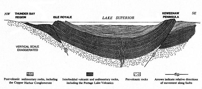
 Cross-section of the Lake Superior basin showing the tilted strata of volcanic rock that form both the Keweenaw Peninsula and Isle Royale
 Lake Superior syncline
geo.wikisort.org - Coast
The Keweenaw Peninsula (/ˈkiːwɪnɔː/ KEE-wi-naw, sometimes locally /ˈkiːvənɔː/) is the northernmost part of Michigan's Upper Peninsula. It projects into Lake Superior and was the site of the first copper boom in the United States, leading to its moniker of "Copper Country." As of the 2000 census, its population was roughly 43,200. Its major industries are now logging and tourism, as well as jobs related to Michigan Technological University and Finlandia University.

Geology
The peninsula measures about 150 miles in length and about 50 miles in width at its base.
The ancient lava flows of the Keweenaw Peninsula were produced during the Mesoproterozoic Era as a part of the Midcontinent Rift between 1.096 and 1.087 billion years ago.[1] This volcanic activity produced the only strata on Earth where large-scale economically recoverable 97 percent pure native copper is found.
Much of the native copper found in the Keweenaw comes in either the form of cavity fillings on lava flow surfaces, which has a ”lacy” consistency, or as "float" copper, which is found as a solid mass. Copper ore may occur within conglomerate or breccia as void or interclast fillings. The conglomerate layers occur as interbedded units within the volcanic pile.[2]
The Keweenaw Peninsula and Isle Royale, formed by the Midcontinent Rift System, are the only sites in the United States with evidence of prehistoric aboriginal mining of copper. Artifacts made from this copper by these ancient indigenous people were traded as far south as present-day Alabama.[3] These areas are also the unique location where chlorastrolite, the state gem of Michigan, can be found.
The northern end of the peninsula is sometimes referred to as Copper Island (or "Kuparisaari" by Finnish immigrants), although this term is becoming less common.[4][5] It is separated from the rest of the peninsula by the Keweenaw Waterway, a natural waterway which was dredged and expanded in the 1860s[6] across the peninsula between the cities of Houghton (named for Douglass Houghton) on the south side and Hancock on the north.
A Keweenaw Water Trail has been established around Copper Island. The Water Trail stretches approximately 125 miles (201 km) and can be paddled in five to ten days, depending on weather and water conditions.
The Keweenaw Fault runs fairly lengthwise through both Keweenaw and neighboring Houghton counties. This ancient geological slip has given rise to cliffs. U.S. Highway 41 (US 41) and Brockway Mountain Drive, north of Calumet, were constructed along the cliff line.


Climate
Lake Superior significantly controls the climate of the Keweenaw Peninsula, keeping winters milder than those in surrounding areas.[7] Spring is cool and brief, transitioning into a summer with highs near 70 °F (21 °C). Fall begins in September, with winter beginning in mid-November.
The peninsula receives copious amounts of lake-effect snow from Lake Superior. Official records are maintained close to the base of the peninsula in Hancock, Michigan,[8] where the annual snowfall average is about 220 inches (560 cm). Farther north, in a community called Delaware, an unofficial average of about 240 inches (610 cm) is maintained. At Delaware, the record snowfall for one season was 390 inches (990 cm) in 1979.[9] Averages over 250 inches (640 cm) certainly occur in the higher elevations closer to the tip of the peninsula.
 Keweenaw Snow-mometer north of Mohawk on US 41
![Some shelf ice remains along the shore of the peninsula as most of the ice breaks away; taken at 11:12:06 AM Central Standard Time on February 20, 2021 from the International Space Station[10]](//upload.wikimedia.org/wikipedia/commons/thumb/f/f9/ISS064-E-35655_-_View_of_Michigan.jpg/305px-ISS064-E-35655_-_View_of_Michigan.jpg) Some shelf ice remains along the shore of the peninsula as most of the ice breaks away; taken at 11:12:06 AM Central Standard Time on February 20, 2021 from the International Space Station[10]
Some shelf ice remains along the shore of the peninsula as most of the ice breaks away; taken at 11:12:06 AM Central Standard Time on February 20, 2021 from the International Space Station[10]![Snow on the peninsula; taken at 2:05:48 PM CST on April 3, 2021 from the ISS[11]](//upload.wikimedia.org/wikipedia/commons/thumb/2/20/ISS064-E-52399_Western_Lake_Superior_and_the_Keweenaw_Peninsula.jpg/305px-ISS064-E-52399_Western_Lake_Superior_and_the_Keweenaw_Peninsula.jpg) Snow on the peninsula; taken at 2:05:48 PM CST on April 3, 2021 from the ISS[11]
Snow on the peninsula; taken at 2:05:48 PM CST on April 3, 2021 from the ISS[11]![Mostly sunny conditions over the peninsula, taken at 2:07:45 PM Central Daylight Time on October 8, 2019 from the ISS[12]](//upload.wikimedia.org/wikipedia/commons/thumb/f/f4/ISS061-E-4566_-_View_of_Earth.jpg/305px-ISS061-E-4566_-_View_of_Earth.jpg) Mostly sunny conditions over the peninsula, taken at 2:07:45 PM Central Daylight Time on October 8, 2019 from the ISS[12]
Mostly sunny conditions over the peninsula, taken at 2:07:45 PM Central Daylight Time on October 8, 2019 from the ISS[12]

![Some shelf ice remains along the shore of the peninsula as most of the ice breaks away; taken at 11:12:06 AM Central Standard Time on February 20, 2021 from the International Space Station[10]](http://upload.wikimedia.org/wikipedia/commons/f/f9/ISS064-E-35655_-_View_of_Michigan.jpg)
![Snow on the peninsula; taken at 2:05:48 PM CST on April 3, 2021 from the ISS[11]](http://upload.wikimedia.org/wikipedia/commons/2/20/ISS064-E-52399_Western_Lake_Superior_and_the_Keweenaw_Peninsula.jpg)
![Mostly sunny conditions over the peninsula, taken at 2:07:45 PM Central Daylight Time on October 8, 2019 from the ISS[12]](http://upload.wikimedia.org/wikipedia/commons/f/f4/ISS061-E-4566_-_View_of_Earth.jpg)
History

Beginning as early as seven thousand years ago and apparently peaking around 3000 B.C., Native Americans dug copper from the southern shore of Lake Superior. This development was possible in large part because, in this region, large deposits of copper were easily accessible in surface rock and from shallow diggings. Native copper could be found as large nuggets and wiry masses. Copper as a resource for functional tooling achieved popularity around 3000 B.C., during the Middle Archaic Stage. The focus of copper working seems to have gradually shifted from functional tools to ornamental objects by the Late Archaic Stage c. 1200 B.C. Native Americans would build a fire to heat the rock around and over a copper mass and, after heating, pour on cold water to crack the rock. The copper was then pounded out, using rock hammers and stone chisels.[13]
The Keweenaw's rich deposits of copper (and some silver) were extracted on an industrial scale beginning around the middle of the 19th century. The industry grew through the latter part of the century and employed thousands of people well into the 20th century. Hard rock mining in the region ceased in 1967 though copper sulfide deposits continued for some time after in Ontonagon. This vigorous industry created a need for educated mining professionals and directly led in 1885 to the founding of the Michigan Mining School (now Michigan Technological University) in Houghton. Although MTU discontinued its undergraduate mining engineering program in 2006, the university continues to offer engineering degrees in a variety of other disciplines. (In 2012 mining engineering was restarted in the re-formed Department of Geological and Mining Engineering and Sciences.)

Running concurrently with the mining boom in the Keweenaw was the white pine lumber boom. Trees were cut for timbers for mine shafts, to heat the communities around the large copper mines, and to help build a growing nation. Much of the logging at the time was done in winter due to the ease of operability with the snow. Due to the logging practices at that time, the forest of the Keweenaw looks much different today from 100 years ago.
US 41 terminates in the northern Keweenaw at the Michigan State Park housing Fort Wilkins. US 41 was the so-called "Military Trail" that started in Chicago in the 1900s and ended in the Keweenaw wilderness. The restored fort has numerous exhibits.
For detailed information on the region's mineralogical history, see the virtual tour of the peninsula written by the Mineralogical Society of America, found in "External links" on this page. Information on the geological formations of the region are also detailed.
From 1964 to 1971, the University of Michigan and Michigan Technological University cooperated with NASA and the U.S. Navy to run the Keweenaw Rocket launch site.
Communities
A partial list of towns in the Keweenaw Peninsula:
|
|
|
See also
- Copper mining in Michigan
- Keweenaw National Historical Park
- Thimbleberry
References
- "Geologic Timeline - Keweenaw National Historical Park (U.S. National Park Service)". www.nps.gov. Retrieved 2018-06-08.
- Huber, N. King (1973). "The Portage Lake Volcanics (Middle Keweenawan) on Isle Royale, Michigan". Geological Survey Professional Paper. Professional Paper. doi:10.3133/pp754C. 754—C.
- Public Law 102-543 (Oct. 27, 1992); 106 STAT. 3569
- Holmio, Armas K. E.; Ryynanen, Ellen M. (2001). History of the Finns in Michigan. Wayne State University Press. p. 76. ISBN 978-0-8143-2974-0. Retrieved 2008-09-28.
- "An Interior Ellis Island: Ethnic Diversity and the Peopling of Michigan's Copper Country, Keweenaw Ethnic Groups: The Finns". MTU Archives and Copper Country Historical Collection. J. Robert Van Pelt Library, Michigan Technological University. Archived from the original on 2007-03-08.
- "Houghton". Exploring the North.
- "Keweenaw". US National Park Serive. Retrieved 21 October 2011.
- "Snowfall Records". Michigan Technological University. Retrieved 21 October 2011.
- "Keweenaw Snowfall Record". Eagle Harbor Web. Retrieved 21 October 2011.
- ISS064-E-35655, Gateway to Astronaut Photography of Earth by the International Space Station program and the JSC Earth Science & Remote Sensing Unit, ARES Division, Exploration Integration Science Directorate
- ISS064-E-52399, Gateway to Astronaut Photography of Earth by the International Space Station program and the JSC Earth Science & Remote Sensing Unit, ARES Division, Exploration Integration Science Directorate
- ISS061-E-4566, Gateway to Astronaut Photography of Earth by the International Space Station program and the JSC Earth Science & Remote Sensing Unit, ARES Division, Exploration Integration Science Directorate
- Martin, Susan R. (1995). "The State of Our Knowledge About Ancient Copper Mining in Michigan". The Michigan Archaeologist. 41 (2–3): 119–138. Archived from the original on 2016-02-07.
Further reading
- Harrison, Jim (November 30, 2013). "Imprint: My Upper Peninsula". The New York Times. Retrieved November 30, 2013.
- Krause, David J. (1992). The Making of a Mining District: Keweenaw Native Copper 1500-1870. Detroit: Wayne State University Press. ISBN 0-8143-2406-1..
- Lankton, Larry (2010). Hollowed Ground: Copper Mining and Community Building on Lake Superior, 1840s-1990s. Detroit: Wayne State University Press. ISBN 978-0-8143-3458-4., focuses on three companies, Calumet & Hecla, Copper Range, and Quincy, in a study of native copper mining and copper-sulfide mining on Upper Michigan's Keweenaw Peninsula.
- Thurner, Arthur W. (1994). Strangers and Sojourners: A History of Michigan's Keweenaw Peninsula. Detroit: Wayne State University Press. ISBN 0-8143-2396-0..
- Primary sources
- Burt, Williams A. & Hubbard, Bela (1846). Reports on the Mineral Region of Lake Superior. Buffalo: L. Danforth.
Bela Hubbard.
.
External links
Wikimedia Commons has media related to Keweenaw Peninsula.
- Keweenaw Convention & Visitors Bureau
- Keweenaw Peninsula Chamber of Commerce
- Keweenaw Time Traveler
- Copper Country Explorer
Upper Peninsula of Michigan | |
|---|---|
| Central cities |
|
| Counties | |
| Geography |
|
| Transportation |
|
| Economy |
|
| |
Lansing (capital) | ||
| Topics |
|  |
| Society |
| |
| Regions |
| |
| Largest municipalities |
| |
| Counties |
| |
Authority control | |
|---|---|
| General |
|
| National libraries | |
На других языках
[de] Keweenaw Peninsula
Die Keweenaw (.mw-parser-output .IPA a{text-decoration:none}ˈkiːwənɔː) Peninsula, genannt auch Keweenaw-Halbinsel, ist der nördlichste Teil der Upper Peninsula in Michigan. Sie ragt in den Oberen See hinein und war die Stätte des ersten Booms auf der Suche nach Kupfer in den Vereinigten Staaten. Heute sind Holzwirtschaft und Touristik die wichtigsten Wirtschaftszweige der Region, auch die Bildung trägt durch die Michigan Technological University und die Finlandia University einen Großteil zur Beschäftigung bei. Der nördliche Endpunkt des bis nach Miami, Florida führenden U.S. Highway 41 liegt bei Copper Harbor.- [en] Keweenaw Peninsula
Текст в блоке "Читать" взят с сайта "Википедия" и доступен по лицензии Creative Commons Attribution-ShareAlike; в отдельных случаях могут действовать дополнительные условия.
Другой контент может иметь иную лицензию. Перед использованием материалов сайта WikiSort.org внимательно изучите правила лицензирования конкретных элементов наполнения сайта.
Другой контент может иметь иную лицензию. Перед использованием материалов сайта WikiSort.org внимательно изучите правила лицензирования конкретных элементов наполнения сайта.
2019-2026
WikiSort.org - проект по пересортировке и дополнению контента Википедии
WikiSort.org - проект по пересортировке и дополнению контента Википедии