geo.wikisort.org - Coast
The Baja California peninsula (Spanish: Península de Baja California, lit. 'lower California peninsula') is a peninsula in northwestern Mexico. It separates the Gulf of California from the Pacific Ocean. The peninsula extends from Mexicali, Baja California, in the north to Cabo San Lucas, Baja California Sur, in the south.
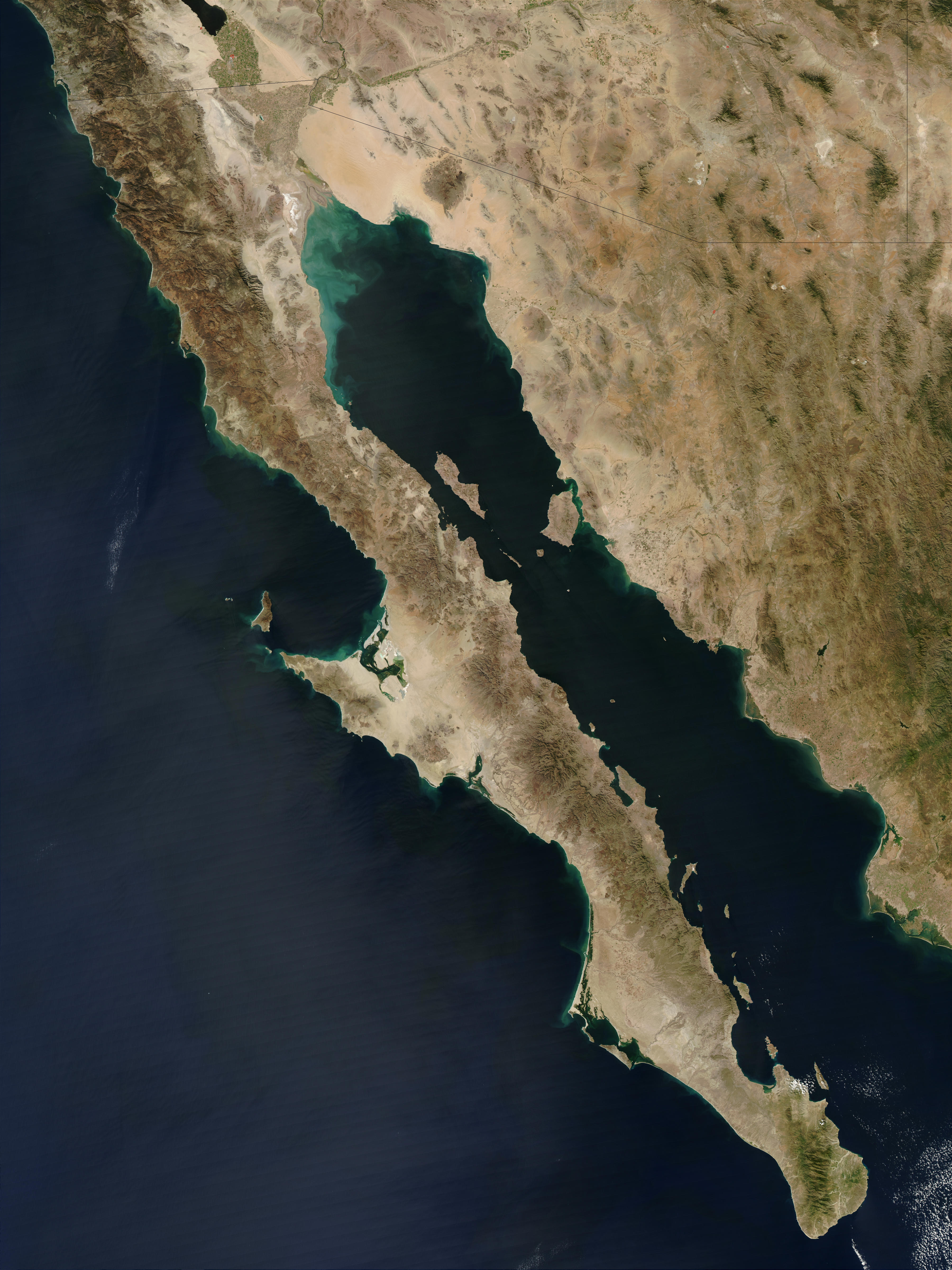 Satellite image of the Baja California peninsula | |
| Geography | |
|---|---|
| Location | Mexico |
| Coordinates | 28°00′N 113°30′W |
| Adjacent to |
|
| Area | 143,390 km2 (55,360 sq mi) |
| Administration | |
Mexico | |
| Demographics | |
| Population | 4,085,695 (2015) |
With a length of 1,247 km (775 miles), its width ranges from 40 km (25 miles) at its narrowest to 320 km (199 miles) at its widest point and has approximately 3,000 km (1,864 miles) of coastline and approximately 65 islands. The total area of the Baja California Peninsula is 143,390 km2 (55,360 sq mi), roughly the same area as the country of Nepal.
The peninsula is separated from mainland Mexico by the Gulf of California and the Colorado River. There are four main desert areas on the peninsula: the San Felipe Desert, the Central Coast Desert, the Vizcaíno Desert and the Magdalena Plain Desert.
History
This section needs additional citations for verification. (February 2022) |
The land of California existed as a myth among European explorers before it was discovered. The earliest known mention of the idea of California was in the 1510 romance novel Las Sergas de Esplandián by Spanish author Garci Rodríguez de Montalvo. The book described the Island of California as being west of the Indies, "very close to the side of the Terrestrial Paradise; and it is peopled by black women, without any man among them, for they live in the manner of Amazons".[1]
Following Hernán Cortés's conquest of Mexico, the lure of an earthly paradise as well as the search for the fabled Strait of Anián, helped motivate him to send several expeditions to the west coast of New Spain in the 1530s and early 1540s. In 1539, explorer Francisco de Ulloa proved that Baja California was a peninsula rather than an island.[2] Nevertheless, the idea of the island persisted for well over a century and was included in many maps.[3] The water separating the island, now called "Gulf of California" was sometimes called the "Red Sea".[4] The Spaniards gave the name Las Californias to the peninsula and lands to the north, including both Baja California and Alta California, the region that became parts of the present-day U.S. states of California, Nevada, Utah, Arizona, and parts of Colorado and Wyoming.[citation needed]
Timeline
- 1532: Hernán Cortés sends three ships north along the coast of Mexico in search of the Island of California. The three ships disappear without a trace.
- 1533: Cortés sends a follow-up mission to search for the lost ships. Pilot Fortún Ximénez leads a mutiny and founds a settlement in the Bay of La Paz before being killed.
- 1539: Francisco de Ulloa explores both coasts.
- 1578 or 1579: The San Juanillo was the Manila galleon which wrecked on a beach at Baja California in late 1578 or early 1579 became the first shipwreck on the coast of the Californias.[5]
- 1622: A map by Michiel Colijn of Amsterdam showed California as a peninsula rather than an island. Previous maps show the Gulf terminating in its correct location.
- 1690s–1800s: Spanish settlement and colonization in lower Las Californias (Baja California peninsula), the first Spanish missions in Baja California are established by Jesuit missionaries.
- 1701: Explorations by Eusebio Kino expanded knowledge of the Gulf of California coast. Kino did not believe California was an island.
- 1767: Jesuits expelled; Franciscans take over the Baja missions.
- 1769: Franciscans go with the Portola expedition to establish new missions in Alta California. Control of the existing Baja missions passes to the Dominican Order.
- 1773: Francisco Palóu's line demarcates Franciscan and Dominican areas of mission control.
- 1804: Las Californias divided into Alta ("Upper") and Baja ("Lower") California, using Palóu's line.
- 1810–1821: Mexican War of Independence
- 1821: First Mexican Empire, Baja California Territory established, covering Baja California Peninsula.
- 1847: The Battle of La Paz and the Siege of La Paz occurs, as well as several other engagements.
- 1848: Treaty of Guadalupe Hidalgo cedes Alta California to the United States. As a U.S. territory it receives the California Gold Rush, causing increased maritime traffic along the peninsula.
- 1850: California admitted to U.S. statehood.
- 1853: William Walker, with 45 men, captures the capital city of La Paz and declares himself President of the Republic of Lower California. Mexico forces him to retreat a few months later.
- 1930–31: The Territory of Baja California is further divided into Northern and Southern territories (North Territory of Baja California and South Territory of Baja California).
- 1952: The North Territory of Baja California becomes the 29th State of Mexico, Baja California. The southern portion, below 28°N, remains a federally administered territory.
- 1973: The 1,700 km (1,056 mi) long Trans-Peninsular Highway (Mexican Federal Highway 1), is finished. It is the first paved road that spans the entire peninsula. The highway was built by the Mexican government to improve Baja California's economy and increase tourism.[6]
- 1974: The South Territory of Baja California becomes the 31st state, Baja California Sur.
Political divisions
This section needs additional citations for verification. (February 2022) |

The province of the Californias was united until 1804, in the Spanish colonial Viceroyalty of New Spain, when it was divided into Alta (upper) and Baja (lower) California.
The two Californias division was kept after Mexican independence in 1821. The Spanish Baja California Province became Mexican Baja California Territory, and remained a separate territory until 1836. In 1836, the Siete Leyes constitutional reforms reunited both Californias in the Departamento de las Californias. After 1848, the Baja California Peninsula again became a Mexican territory when Alta California was ceded to the United States (see 1854 map).
In 1931 Baja California Territory was divided into northern and southern territories. In 1952, the "North Territory of Baja California" became the 29th State of Mexico as Baja California. In 1974, the "South Territory of Baja California" became the 31st state as Baja California Sur.
Baja California

The northern part is the state of Baja California. It is sometimes informally referred to as Baja California Norte, to distinguish it from both the Baja California Peninsula and the adjacent state Baja California Sur. The citizens of Baja California are named bajacalifornianos ("Lower Californians" in English). Mexicali is the capital.
Baja California Sur

The southern part, below 28° north, is the state of Baja California Sur. The citizens of Baja California Sur are named sudcalifornianos ("South Californians" in English). La Paz is its capital.
Geology
The Baja California Peninsula was once a part of the North American Plate, the tectonic plate of which mainland Mexico remains a part. About 12 to 15 million years ago the East Pacific Rise began cutting into the margin of the North American Plate, initiating the separation of the peninsula from it. Spreading within the Gulf of California consists of short oblique rifts or ridge segments connected by long northwest trending transform faults,[7] which together comprise the Gulf of California Rift Zone. The north end of the rift zone is located in the Brawley seismic zone in the Salton Sea basin between the Imperial Fault and the San Andreas Fault.[7] The Baja California Peninsula is now part of the Pacific Plate and is moving with it away from the East Pacific Rise in a north northwestward direction.
Along the coast north of Santa Rosalia, Baja California Sur is a prominent volcanic activity area.
Volcanoes of the peninsula and adjacent islands include:[8]
- Volcanoes of east-central Baja California
- Cerro Prieto
- The San Quintín Volcanic Field
- Isla San Luis
- Jaraguay volcanic field
- Coronado
- Guadalupe
- San Borja volcanic field
- El Aguajito
- Tres Vírgenes
- Isla Tortuga
- Comondú-La Purísima
Researchers from Scripps Institution of Oceanography have found a 2,000-year-old layer of non-decomposed roots, or peat, up to 4 metres (13 ft) under the desert mangroves. The peat layer acts like a sponge for stored atmospheric carbon, a record of sea-level-rise is also recorded in the peat layer.
The desert mangroves restricted to rocky inlets on the rugged coast of Baja California have been growing over their own root remains over thousands of years to compensate for sea-level rise, accumulating a thick layer of peat below their roots. However, mangroves in flat coastal floodplains have accumulated a thinner peat layer.[9]
Geography

The Peninsular Ranges form the backbone of the peninsula. They are an uplifted and eroded Jurassic to Cretaceous batholith, part of the same original batholith chain which formed much of the Sierra Nevada mountains in U.S. California. This chain was formed primarily as a result of the subduction of the Farallon Plate millions of years ago all along the margin of North America.
- The Sierra de Juárez is the northernmost range in Mexico.
- The Sierra San Pedro Mártir runs south of the Sierra Juarez and includes the peninsula's highest peak, the Picacho del Diablo.
- The Sierra de San Borja runs south of the Sierra San Pedro Martir.
- The volcanic complex of Tres Virgenes lies in Baja California Sur, near the border with the state of Baja California, forming the ranges south of the Sierra de San Borja.
- The Sierra de la Giganta runs along the shore of the Gulf of California south of the Tres Virgenes complex.
- At the south end of Baja California Sur, the Sierra de la Laguna forms an isolated mountain range rising to 2,090 metres (6,860 ft)
- Another isolated range, the Sierra Vizcaino, juts out into the Pacific between Punta Eugenia and Punta Abreojos.
The two most prominent capes along the Pacific coastline of the peninsula are Punta Eugenia, located about halfway up the coast, and Cabo San Lazaro, located about a quarter of the way north from Cabo San Lucas.
The Bahia Sebastian Vizcaino, the largest bay in Baja, lies along the Pacific coast halfway up the peninsula. The large island of Isla Cedros is situated between the bay and the Pacific, just north of Punta Eugenia. Onshore southeast of the bay is the Desierto de Vizcaino, an extensive desert lying between the Sierra Vizcaino to the west, and the Tres Virgenes range which runs along the Gulf of California to the east.
The largest bays along the coastline of the Gulf are Bahia de La Paz where the city of La Paz is located, and Bahia Concepcion. The Bahía de los Ángeles is a small bay located west of the Canal de las Ballenas which separates the Baja California peninsula from the large island of Angel de la Guarda in the Gulf of California.
Ecoregions
The peninsula is home to several distinct ecoregions. Most of the peninsula is deserts and xeric shrublands, although pine-oak forests are found in the mountains at the northern and southern ends of the peninsula. The southern tip of the peninsula, which was formerly an island, has many species with affinities to tropical Mexico.
- California chaparral and woodlands, which covers the Mediterranean climate northwestern corner of the peninsula, as well as Cedros and Guadalupe islands.
- Sierra Juarez and San Pedro Martir pine-oak forests in the upper reaches of the Sierra Juárez and Sierra San Pedro Mártir ranges in the northern peninsula.
- The Sonoran Desert extends into the northeastern portion of the state, east of the Sierra Juárez and Sierra San Pedro Mártir ranges.
- The Baja California Desert extends west of the Peninsular Ranges along the Pacific side of the peninsula for most of its length, and includes the El Vizcaíno Desert and El Vizcaíno Biosphere Reserve.
- The Gulf of California xeric scrub extends along the Gulf of California side of the peninsula for most of its length.
- San Lucan xeric scrub lies in the lowlands of the peninsula's southern tip.
- Sierra de la Laguna dry forests are found on the lower slopes of the Sierra de la Laguna.
- Sierra de la Laguna pine-oak forests are found at higher elevations in the Sierra de la Laguna.
- The Bahía de los Ángeles Biosphere Reserve
Tourism
The peninsula is known colloquially as Baja by American and Canadian tourists, and is known for its natural environment. It draws ecotourists who go whale watching for migrating California gray whales as well as tourists that arrive to the resorts on the southern tip of the Peninsula. Its location between the North Pacific and Gulf of California give it a reputation for sports fishing. Since 1967, the peninsula has hosted the Baja 1000, an off-road race that begins in Ensenada and ends in La Paz.
See also
- Gulf of California Rift Zone
- Spanish missions in Baja California
- The Californias
- Ferdinand Konščak
References
- Notes
- "Spain's Fantastic Vision and the Mythic Creation of California" (PDF). Archived from the original (PDF) on 2017-05-25. Retrieved 2017-01-31.
- "Gulf of California". Encyclopaedia Britannica.
- Jennings, Ken (March 19, 2018). ""For Centuries, Europeans Thought California Was an Island"". Condé Nast Traveler.
- "California as Island? The Valk Map in the USC Chronicle | USC Libraries". libraries.usc.edu. Retrieved 2021-04-04.
- Von der Porten, Edward (2019). Ghost Galleon: The Discovery and Archaeology of the San Juanillo on Shores of Baja California. Texas A&M University Press. p. 208.
- Barkenbus, Jack, "The Trans-Peninsular Highway: A New Era for Baja California", Journal of Interamerican Studies and World Affairs, Vol. 16, No. 3. (Aug., 1974), pp. 259–273.
- Alles, David L. "Geology of the Salton Trough" (PDF). Archived (PDF) from the original on 2012-03-02. Retrieved 2016-12-18.
- "Global Volcanism Program | Volcanoes of the World | Volcanoes of México and Central America | México". Archived from the original on 2010-06-14. Retrieved 2010-01-10. Volcanoes of México and Central America
- "New Study Shows Desert Mangroves Are Major Source of Carbon Storage | Scripps Institution of Oceanography, UC San Diego". scripps.ucsd.edu. 2016-03-28. Archived from the original on 2016-04-09. Retrieved 2016-03-30.
- Sources
Further reading
- MacDonald, Gregory (2019). Isle of the Amazons In the Vermilion Sea. Kansas City, MO: 39 West Press. ISBN 978-1-946358-14-1. An anthology of writings that describe Baja California, and the Gulf of California, from sources dated from the mid-sixteenth century to present.
External links
 Baja California travel guide from Wikivoyage
 Works related to Lower California at Wikisource
Authority control | |
|---|---|
| General | |
| National libraries | |
| Other | |
На других языках
[de] Niederkalifornien
Niederkalifornien (spanisch Baja California) ist eine schmale Halbinsel im Westen Mexikos von 1200 Kilometern Länge und 80 bis 220 Kilometern Breite. Sie liegt parallel zur mexikanischen Westküste und geht an ihrem nördlichen Ende ins mexikanische Festland über. Auf ihr liegen die mexikanischen Bundesstaaten Baja California Sur (Süd-Niederkalifornien) und Baja California (Niederkalifornien), das sich über das mexikanische Festland nach Norden bis an den US-Bundesstaat Kalifornien erstreckt. Sie ist so groß wie die Apennin-Halbinsel Italiens und etwa doppelt so lang wie der US-Bundesstaat Florida. Den größten Teil ihrer Fläche nehmen die Wüste Sonora und die Gebirgskette der Peninsular Ranges ein. Die Herkunft des Namens „Kalifornien“ ist unklar, wahrscheinlich ist er aus dem Ritterroman Las sergas de Esplandián von Garci Rodríguez de Montalvo übernommen oder leitet sich von der Bezeichnung calida forna – „heißer Ofen“ – her. Die Region um die Halbinsel ist tektonisch aktiv, die Caldera Aguajito entstand bei einem Vulkanausbruch vor etwa 760.000 Jahren.- [en] Baja California peninsula
[es] Península de Baja California
La península de Baja California (también denominada península de la Baja California), está localizada al noroeste de México. Penetra en el océano Pacífico, formando el golfo de California entre su costa oriental y las costas de Sonora y Sinaloa. Tiene una longitud aproximada de 1250 km y comprende los estados mexicanos de Baja California y Baja California Sur.[1] Inicia en la frontera de México con Estados Unidos y termina en un cabo con enormes formaciones rocosas, entre las que se encuentra el llamado Arco Monumental.[ru] Калифорния (полуостров)
Калифо́рния (Нижняя Калифорния, исп. Baja California или Калифорнийский полуостров) — длинный и узкий полуостров на западе Северной Америки, в северо-западной Мексике. Омывается Тихим океаном на западе и Калифорнийским заливом на востоке. Его длина составляет 1200 км, а максимальная ширина 240 км. На полуострове расположены мексиканские штаты Нижняя Калифорния и Южная Нижняя Калифорния. По площади (144 тыс. км²) полуостров соразмерен с Апеннинским полуостровом (ок. 149 тыс. км²) и является в два раза более крупным, чем Флорида. Бо́льшая часть Нижней Калифорнии представляет собой пустыню (Сонора и Нижнекалифорнийская пустыня).Другой контент может иметь иную лицензию. Перед использованием материалов сайта WikiSort.org внимательно изучите правила лицензирования конкретных элементов наполнения сайта.
WikiSort.org - проект по пересортировке и дополнению контента Википедии