geo.wikisort.org - Island
Guadalupe Island or Isla Guadalupe is a volcanic island located 241 kilometres (130 nautical miles) off the west coast of Mexico's Baja California Peninsula and about 400 km (200 nmi) southwest of the city of Ensenada in the state of Baja California, in the Pacific Ocean.[1] The various volcanoes are extinct or dormant. In 2005 Guadalupe Island and its surrounding waters and islets were declared a biosphere reserve to restore its vegetation (decimated by goats) and to protect its population of marine mammals and birds. The island is a popular destination for white shark cage diving. Guadalupe Island is inhabited only by scientists, military personnel operating a weather station, and a small group of seasonal fishermen. The island is mostly arid and has very little surface water.
This article is missing information about the discovery of the island. (February 2022) |
Isla Guadalupe | |
|---|---|
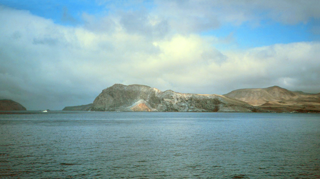 Southeast coast of Guadalupe Island | |
 Guadalupe Map of Guadalupe Island, Mexico Guadalupe Guadalupe (Mexico) | |
| Geography | |
| Location | Pacific Ocean |
| Coordinates | 29°1′51″N 118°16′48″W |
| Area | 243.988 km2 (94.204 sq mi) |
| Highest elevation | 4,257 ft (1297.5 m) |
| Highest point | Mount Augusta |
| Administration | |
Mexico | |
| State | Baja California |
| Municipality | Ensenada |
| Delegación | Ensenada |
| Demographics | |
| Population | 213 (2010) |
| Additional information | |
| Official language: Spanish | |
The two other Mexican island groups in the Pacific Ocean that are not on the continental shelf are the Revillagigedo Islands and Rocas Alijos. Guadalupe Island and its islets are the westernmost region of Mexico.[2]
Administration and population
The 2010 census recorded a population of 213 people on the island.[3] In 2015, it was estimated to have fewer than 150 permanent residents.[4] Guadalupe is part of Ensenada delegación, one of the 24 delegaciones or subdivisions of Ensenada Municipality of the Mexican state of Baja California. Ensenada delegación and Chapultepec delegación together form the city of Ensenada, the municipal seat of the namesake municipality. The postal code of Guadalupe Island is 22997.
Campo Oeste ("West Camp", also called Campo Tepeyac, with 15 buildings) is a small community of abalone and lobster fishermen, located on the western coast,[5] specifically on the north side of West Anchorage, a bay that provides protection from the strong winds and swells that whip the islands during winter. Generators provide electricity, and a military vessel brings 30,000 litres (7,900 US gal)[citation needed] of freshwater. The number of fishermen varies annually depending on the fishing season. Ten months of the year the 30 families of the fishing cooperative "Abuloneros and Langosteros of Guadalupe Island" are present.[6]
Additional temporary fishing camps are Campo Norte ("North Camp", four buildings), Campo Lima (Campo Corrals) (one building) and Arroyitos (four buildings).[7]
At the southern tip, on Melpómene Cove, there is a weather station staffed by a detachment from the Mexican Ministry of the Navy.[when?] The site is called Campamento Sur ("South Encampment").[citation needed]
Campo Bosque was established as a temporary camp in 1999 in the cypress forest in the north. The camp houses members of the Cooperative Farming Society "Francisco Javier Maytorena, S.C. of R.L." and removes goats from the island and sells them in the State of Sonora, with permission of Secretariat of the Environment and Natural Resources (SEMARNAT) and the support of the Secretariat of the Navy.
Campo Pista is located at the small airport, near the center of the island (29°01′24.04″N 118°16′21.75″W, elevation:592 m, direction:05/23). Airport Isla Guadalupe (ICAO Code MMGD) has a 1,200-metre-long (3,900 ft) runway. At the end of the runway near threshold 5 is the wreckage of a Lockheed Model 18 Lodestar,[8] which overshot the runway during landing. A North American B-25J-30/32 Mitchell, BMM-3501 (c/n 44-86712), bomber wrecked on the opposite end of the runway, after suffering serious damage in trying to take-off overloaded (29°01′36.10″N 118°16′2.98″W). Based on historical Google Earth imagery, this B-25 wreckage appears to have been removed from the location between October, 2005, and June, 2006.[9]
Because Guadalupe Island is located within a biosphere reserve, anyone visiting the island must obtain a permit from the Mexican government; this means the communities on the island are closed towns.[5][10][11]
Geology

Guadalupe Island has a rugged landscape composed of two shield volcanoes which formed on a now extinct mid-ocean ridge.[12][13] They are overlain by lava flows and cinder cones that were emplaced along northwest-southeast and northeast-southwest trending fissure vents. The youngest shield volcano comprises the northern end of the island and may have formed during the Holocene epoch. A series of very fresh-looking alkali basalt flows along with trachyte domes in the northern shield volcano caldera represent the most recently formed rocks on Guadalupe Island.[13]
Geography
The island measures 35 kilometres (22 mi) north-south and up to 9.5 kilometres (6 mi) east-west, with a total area of 243.988 km2 (94+13⁄64 sq mi). It features a chain of high volcanic mountain ridges which rises to a height of 1,298 metres (4,259 ft) at its northern end (Mount Augusta). Its smaller counterpart on the southern end is the 975 metres (3,199 ft) El Picacho.[14] The southern part of the island is mostly barren, but there are scattered stands of trees at at higher elevations of the northern part of the island and in the Twin Canyon area on the northeast coast. The coast generally consists of rocky bluffs with detached rocks fronting some of them. Two high and prominent islets are within three kilometres (1.9 mi) of the southwestern end of the island, separated from one another by a gap called Tuna Alley:
- Islote Afuera (Outer Islet, also Islote Zapato), 28°51′53″N 118°17′41″W, 1.5 ha (4 acres), the most distant, steep with almost vertical walls above and below water
- Islote Adentro (Inner Islet, also El Toro), 28°52′18″N 118°17′34″W, 0.393 km2 (97 acres), with two smaller islets nearby:
- Church Rock
- Roca del Skip
Elsewhere, the other islets are very small and close to the shore, all less than one kilometre (1⁄2 nmi) away:
- Islote Negro, 28°54′23″N 118°17′18″W, 8.8 ha (21+3⁄4 acres), to the southwest
- Roca Hundida, 28°55′00″N 118°18′00″W, 0.3 ha (3⁄4 acre), to the southwest
- Islote Bernal, 28°56′04″N 118°17′53″W, 1.1 ha (2+3⁄4 acres), to the southwest
- Palto Muerto, 28°56′49″N 118°17′42″W, 0.5 ha (1+1⁄4 acres), 2 km (1 nmi) north of Islote Bernal
- unnamed islet, 28°56′59″N 118°17′48″W, 0.2 ha (1⁄2 acre), 4 km (2 nmi) north of Islote Bernal
- Steamboat Rock, 0.3 ha (3⁄4 acre), to the west
- Roca Elefante, 0.1 ha (1⁄4 acre), to the northwest (the westernmost)
- Roca Elefante is the westernmost point in both Mexico and Latin America.[2]
Climate
The island has two major climate zones: a very arid, semi-hot climate between 0 and 800 metres (0 and 2,625 feet) elevation, with mean annual temperature between 18 and 22 °C (64 and 72 °F) and a very arid, temperate climate above 800 metres (2,600 ft) elevation with temperatures over 22 °C (72 °F) in the hottest month of the year.
Most precipitation occurs over the winter months with a strong influence of northwestern winds and cyclones.
Rainfall averages 133 millimetres (5.2 in) near sea level at the south end but appears to be much more at the high north end. An estimate for the rainfall in the northern highlands is possible by way of taking Pinus radiata as an indicator, which is native to that area of the island. In other places where Pinus radiata is native, it grows best with about 750 millimetres (30 in) of rainfall but under some conditions can survive with as little as half that much. The effective moisture is much greater because of fog drip.[15]
| Month | Jan | Feb | Mar | Apr | May | Jun | Jul | Aug | Sep | Oct | Nov | Dec | Year |
|---|---|---|---|---|---|---|---|---|---|---|---|---|---|
| Record high °C (°F) | 27.8 (82.0) |
30.0 (86.0) |
30.0 (86.0) |
28.4 (83.1) |
29.5 (85.1) |
31.3 (88.3) |
31.7 (89.1) |
35.0 (95.0) |
32.2 (90.0) |
32.2 (90.0) |
30.6 (87.1) |
28.8 (83.8) |
35.0 (95.0) |
| Average high °C (°F) | 18.9 (66.0) |
19.6 (67.3) |
19.8 (67.6) |
20.1 (68.2) |
20.8 (69.4) |
21.8 (71.2) |
23.0 (73.4) |
23.9 (75.0) |
24.2 (75.6) |
23.2 (73.8) |
21.6 (70.9) |
20.1 (68.2) |
21.4 (70.5) |
| Daily mean °C (°F) | 15.5 (59.9) |
15.6 (60.1) |
15.6 (60.1) |
16.1 (61.0) |
16.7 (62.1) |
17.6 (63.7) |
19.0 (66.2) |
20.1 (68.2) |
20.3 (68.5) |
19.4 (66.9) |
17.9 (64.2) |
16.3 (61.3) |
17.5 (63.5) |
| Average low °C (°F) | 11.8 (53.2) |
11.6 (52.9) |
11.6 (52.9) |
12.0 (53.6) |
12.4 (54.3) |
13.1 (55.6) |
14.5 (58.1) |
15.9 (60.6) |
16.4 (61.5) |
15.5 (59.9) |
13.8 (56.8) |
12.5 (54.5) |
13.4 (56.1) |
| Record low °C (°F) | 3.5 (38.3) |
3.4 (38.1) |
2.2 (36.0) |
1.0 (33.8) |
6.2 (43.2) |
7.6 (45.7) |
8.0 (46.4) |
8.8 (47.8) |
5.4 (41.7) |
6.2 (43.2) |
4.5 (40.1) |
0.9 (33.6) |
0.9 (33.6) |
| Average precipitation mm (inches) | 16.3 (0.64) |
21.6 (0.85) |
18.0 (0.71) |
9.5 (0.37) |
1.1 (0.04) |
1.2 (0.05) |
0.4 (0.02) |
0.2 (0.01) |
0.6 (0.02) |
5.1 (0.20) |
12.3 (0.48) |
22.2 (0.87) |
108.5 (4.27) |
| Average precipitation days (≥ 0.1 mm) | 2.16 | 2.00 | 2.55 | 1.10 | 0.37 | 0.14 | 0.12 | 0.07 | 0.17 | 0.82 | 1.89 | 2.32 | 13.71 |
| Average relative humidity (%) | 79 | 79 | 78 | 78 | 79 | 82 | 83 | 81 | 81 | 80 | 79 | 79 | 80 |
| Source: Colegio de Postgraduados[16] | |||||||||||||
Ecology


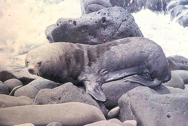
Guadalupe Island was a major destination for Russian and American fur hunters seeking the Guadalupe fur seal (Arctocephalus townsendi) in the 18th and 19th centuries until they were nearly extinct by 1844. Captain Auguste Duhaut-Cilly reported in 1827 that a Sandwich Islands (Hawaiian Islands) brig "had spent several months there and collected three thousand sealskins".[17] The northern elephant seal (Mirounga angustirostris) was also ruthlessly hunted for the oil in its blubber.
They were thought to be extinct in 1884 until a remnant population of eight individuals was discovered on Guadalupe Island in 1892 by a Smithsonian expedition, who promptly killed several of them for their collections.[18] The elephant seals managed to survive, and were finally protected by the Mexican government in 1922.[19]
Guadalupe shares the California chaparral and woodlands ecoregion with the Channel Islands of California in the United States, but the island was at one time practically denuded of all plants higher than a few centimeters by up to 100,000[note 1] feral goats.
Originally brought there in the 19th century by European whalers and sealers for provisions when stopping over, the population eventually eliminated most vegetation; the number of goats declined to a few thousand. Before this collapse, the main impact of the goat population was about the turn of the 19th/20th century. Naturalist A.W. Anthony wrote in 1901:
"It is directly due to the despised Billy-goat that many interesting species of plants formerly abundant are now extinct, and also that one or more of the birds peculiar to the island has disappeared, and others are following rapidly."[20]
After the crash, the goat population once again grew, this time more slowly, until it had reached the new, lower carrying capacity at maybe 10,000–20,000 in modern times. The island had been a nature conservancy area since August 16, 1928, making it one of the oldest reserves in Mexico. Eradication of the goats was long envisioned, but logistical difficulties such as island size and lack of suitable spots for landing and encamping hunters and material prevented this. In 2002, the Mexican government (including SEMARNAT) and the conservation group Grupo de Ecología y Conservación de Islas began eliminating the goats.[5] In June 2005, after many years of false starts, the Mexican government had almost completed a round-up and evacuation of the remaining goat population. In 2007, the goat elimination program ended (10,000 feral goats were eliminated).[5] Guadalupe Island was designated a biosphere reserve on April 25, 2005.[5]
French sea captain Auguste Duhaut-Cilly remarked on the tall trees on the north of Guadalupe Island as he sailed past on January 2, 1827.[17] Of the large tree species on Guadalupe Island (Guadalupe palm, Guadalupe cypress, island oak, and Guadalupe pine), there were only old individuals left; California juniper had entirely disappeared. As the goats ate any seedlings that managed to germinate, no regeneration of trees was possible. Water, formerly plentiful as the common fogs condensed in the forests of the northern end of the island, today only occurs in a few scattered pools and springs. Because the springs were a critical emergency water supply for the human inhabitants, protective measures including goat fences were installed beginning in 2000, allowing new seedlings of many species to survive for the first time in 150 years. Seacology, a non-profit environmental group located in Berkeley, CA, provided funding to the Island Conservation & Ecology Group for the construction of ten fenced exclosures to keep goats out of the most sensitive areas of Guadalupe Island.
In November 1850, U.S. Army Lt. George H. Derby passed the island on his expedition in the U.S. Transport Invincible. He described it thus: "This island is about 15 miles length and 5 in width. It is rocky + mountainous but capped with vegetation and is reputed to be thickly inhabited by wild goats of unusual size. Water is found upon the eastern shore and the Island is frequently visited by small vessels engaged in the capture of the sea elephant numbers of which animals are found upon its coast."
Many islands or marine species that reside on or near Guadalupe also frequent the Channel Islands, and vice versa. In stark contrast to the rampant extinction of terrestrial life that happened at the same time, Guadalupe was the last refuge for the northern elephant seal (Mirounga angustirostris) and the Guadalupe fur seal (Arctocephalus townsendi) in the 1890s. The island has been a pinniped sanctuary since 1975.
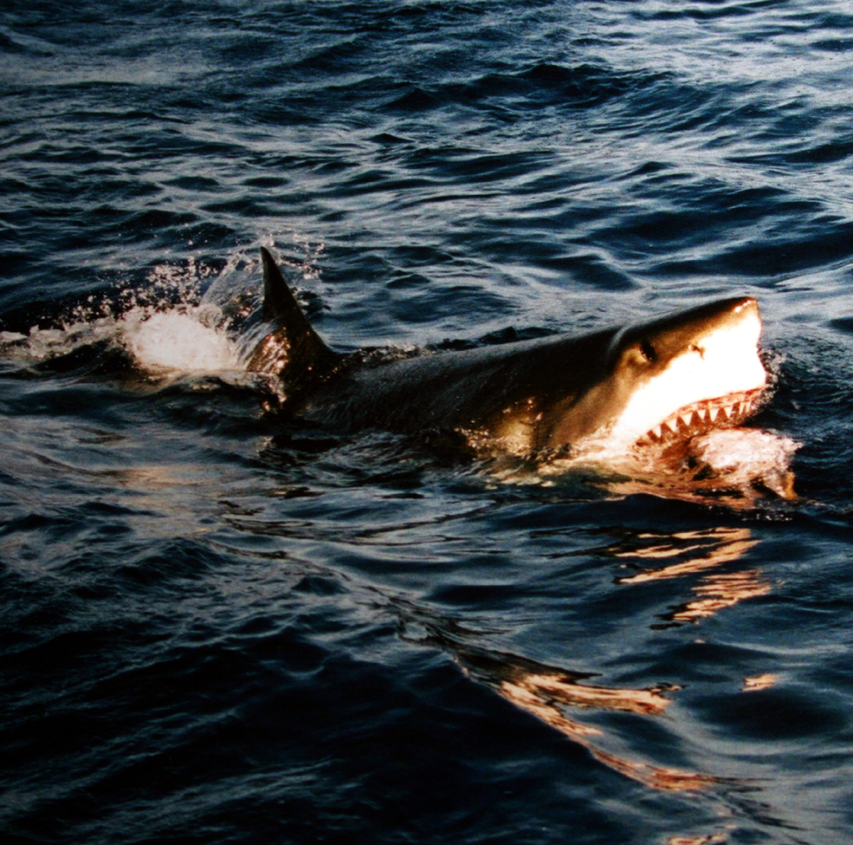
The movement of the cool, nutrient-rich water current promotes phytoplankton production and attracts both coastal and deep-water species, including great white sharks.[21]
Guadalupe is considered one of the best spots in the world for sightings of the great white shark, possibly because of its large population of pinnipeds.[22] The island has been recognised as an Important Bird Area (IBA) by BirdLife International.[23]
Habitat types
Before the removal of goats, surveys found eight major land habitats on Guadalupe:[24][25]


- Flora of the coastal lowlands and rocky cliffs: mainly up to 200 metres (660 ft) above mean sea level (ASL), but higher on the steep cliffs. Largely unresearched due to difficult access, the cliffs might even harbor remnant specimens of the presumably extinct plants.
- Succulent perennial herbs: 200–400 metres (660–1,310 ft) ASL, chiefly on the southern end and on the offshore islets, and in less steep areas towards sea level. Here, the highest number of endemic plants exist. Baeriopsis guadalupensis, Cistanthe guadalupensis, Dudleya guadalupensis, Hemizonia greeneana ssp. greeneana, H. palmeri, Perityle incana and Stephanomeria guadalupensis are dominant endemics, and giant coreopsis (Coreopsis gigantea), a non-endemic native species, is also abundant.
- Arid maritime shrubland: 400–600 metres (1,300–2,000 ft) ASL. Mainly in the southern portion around El Picacho. Native species occurring here include Ambrosia camphorata, Atriplex barclayana, Cylindropuntia prolifera and California boxthorn (Lycium californicum); none of these is endemic.
- Herbland dominated by introduced plants: 600–800 metres (2,000–2,600 ft) ASL, mainly on the central plateau. This habitat is almost entirely a consequence of overgrazing; hardly anything of the original ecosystem remains. Dominant introduced plants are Avena barbata, Bromus berteroanus, great brome (B. diandrus), soft brome (B. hordeaceus sspp. hordaceus and mollis), red brome (B. madritensis ssp. rubens), tocalote (Centaurea melitensis), nettle-leaved goosefoot (Chenopodium murale), Filago californica, wall barley (Hordeum murinum sspp. glaucum and leporinum), crystalline iceplant (Mesembryanthemum crystallinum), M. nodiflorum, Polypogon monspeliensis and Sisymbrium orientale. The non-endemic natives dwarf coastweed (Amblyopappus pusillus), island false bindweed (Calystegia macrostegia ssp. macrostegia), Cryptantha maritima var. maritima, Filago arizonica, Gilia nevinii, California goldfields (Lasthenia californica), Pectocarya palmeri and Perityle emoryi as well as the endemics Cryptantha foliosa and Sphaeralcea palmeri can be found here also; some are still numerous. This probably was a mesic shrub/herbland before the goats destroyed the upland forest, upsetting the water supply. Native plants still found on Guadalupe, like Crossosoma californicum, laurel sumac (Malosma laurina) and the endemic Camissonia guadalupensis ssp. guadalupensis, presumably thrived here in former times, as would have such taxa as the native hoary-leaved ceanothus (Ceanothus crassifolius), wedge-leaved ceanothus (C. cuneatus) – and possibly also felt-leaved ceanothus (C. arboreus), which was found in 2001–2003 surveys[26] –, Cammisonia robusta, red-flowering currant (Ribes sanguineum) and the endemic Hesperelaea palmeri, which have now disappeared from the island.
- Guadalupe palm groves: 400–900 metres (1,300–3,000 ft) ASL on the northwest side of the island. There are hundreds of palm trees remaining, mainly in a single patch of this habitat. At least one other major palm forest existed at the W coast; it was still present in 1906 at "Steamer Point".[27] As reproduction is presumably still ongoing, the species will likely recover in due time.
- Guadalupe cypress forest: 800–1,000 metres (2,600–3,300 ft) ASL. Presently some 4000 old trees, essentially limited to the central northern part. Other cypress forests, such as a major stand NE of the present patch which was still extant in 1906,[27] have been destroyed by the goats early in the 20th century. There is still reproduction, but the water table appears to have declined to below the level required by the cypresses, and mortality of the old trees is high and can be expected to continue even after the removal of the goats.
- Guadalupe palm – island oak – Guadalupe pine woodland: 900–1,000 metres (3,000–3,300 ft) ASL. This habitat has all but disappeared during the 20th century,[27] due to the decline in numbers of the oaks and pines.
- Guadalupe pine cloud forest with some island oak: restricted to above 1,000 metres (3,300 ft) ASL on the N-NE point of the island. The population of the pine has declined by about two-thirds during the last 35 years; it presently stands at about 130 old trees in the main population and about the same number scattered elsewhere. Reproduction is ongoing, with several hundred seedlings having successfully established themselves since 2000,[26] and with the elimination of goat browsing, the pines will likely make a full recovery. The situation of the oak is direr; there are only 20 trees or so remaining (by about 1950, there were 100) and they appear past reproductive age. Not being restricted to Guadalupe, seedlings could be imported from elsewhere.
A ninth habitat type, California juniper woodland and extending on the central plateau below the cypress forest, was entirely gone by 1906.[27] What other endemic lifeforms underwent coextinction with it will forever remain unknown.
Endemism
Animals:
- Guadalupe fur seal (Arctocephalus townsendi) – only major breeding site
- Townsend's storm petrel (Oceanodroma socorroensis) – only known breeding site

- Ainley's storm petrel (Oceanodroma cheimomnestes) – only known breeding site
- Guadalupe rock wren (Salpinctes obsoletus guadalupensis) – endemic
- Guadalupe house finch (Carpodacus mexicanus amplus) – endemic
- Guadalupe pipefish (Syngnathus insulae) – endemic
- Guadalupe junco (Junco insularis) – endemic
- Guadalupe caracara (Caracara lutosa) – endemic, extinct
- Guadalupe Bewick's wren (Thryomanes bewickii brevicauda) – endemic, extinct
- Endemic spiders:[28]
- Habronattus gigas
- Herpyllus giganteus
- Kibramoa isolata
- Sergiolus guadalupensis
- Baeriopsis guadalupensis – near-endemic
- Brahea edulis (Guadalupe palm) – effectively endemic[note 2]
- Camissonia guadalupensis ssp. guadalupensis – endemic
- Castilleja fruticosa – endemic
- Cistanthe guadalupensis – endemic
- Cupressus guadalupensis var. guadalupensis (Guadalupe cypress) – endemic
- Cryptantha foliosa – endemic
- Deinandra frutescens – endemic
- Deinandra greeneana ssp. greeneana – endemic
- Deinandra palmeri – endemic
- Dudleya guadalupensis – endemic
- Dudleya virens ssp. extima – endemic
- Eriogonum zapatoense – endemic
- Erysimum moranii – endemic
- Eschscholzia elegans – near-endemic
- Eschscholzia palmeri – endemic
- Galium angulosum – endemic
- Githopsis diffusa var. guadalupensis – endemic
- Hemizonia frutescens – endemic
- Hemizonia greeneana ssp. greeneana – endemic
- Hemizonia palmeri – endemic
- Heteromeles arbutifolia var. macrocarpa – probably endemic
- Lavatera lindsayi – endemic
- Lupinus niveus – endemic
- Marah guadalupensis – near-endemic or endemic[note 3]
- Perityle incana – endemic
- Phacelia phyllomanica – endemic
- Pinus radiata var. binata (Guadalupe Island Monterey pine) – near-endemic or endemic[note 4][25]
- Satureja palmeri – endemic; rediscovered in 2001–2003 surveys[26]
- Senecio palmeri – endemic
- Sphaeralcea palmeri – endemic
- Sphaeralcea sulphurea – endemic
- Stephanomeria guadalupensis – endemic
- Triteleia guadalupensis – endemic
Extinctions
Numerous taxa have gone extinct due to the habitat destruction by the goats, which in turn rendered the endemic fauna vulnerable to predation by introduced cats and adverse weather by depriving them of shelter.
There have been 5–6 extinctions of birds:
- Guadalupe Bewick's wren (Thryomanes bewickii brevicauda), late 1890s,[20][29]
- Guadalupe spotted towhee (Pipilo maculatus consobrinus), late 1890s
- The Guadalupe caracara (Polyborus lutosus) was intentionally made extinct by humans around 1901, ironically because it occasionally preyed on young goats.
- Guadalupe flicker (Colaptes cafer rufipileus), c. 1910 – the island was later recolonized by individuals of the nominate subspecies
- Guadalupe storm petrel (Oceanodroma macrodactyla), 1910s
- The Guadalupe ruby-crowned kinglet (Regulus calendula obscurus) is close to extinction if it indeed still exists. It was not observed in 2000 despite thorough searches.
Globally extinct plant taxa from Guadalupe Island are:[24][25][26]
- Castilleja guadalupensis
- Hesperelaea palmeri
- Pogogyne tenuiflora
and one species of plant Incertae sedis
Notes
Its time zone is Pacific Standard Time
- Maximum population that was reached in the late 19th century; nearly 2 goats per acre/more than 4/ha: León de la Luz et al. (2003)
- Some naturalized populations exist in California
- Depending whether this population belongs to Marah macrocarpus var. major or not
- Depending on taxonomic status of Cedros Island population
References
- http://www.scielo.org.mx/pdf/hbio/v23n3/v23n3a14.pdf [bare URL PDF]
- https://www.worldatlas.com/articles/the-most-extreme-points-of-mexico.html Worldatlas.com. The Most Extreme Points of Mexico. Retrieved August 18, 2018.
- "Censo de Población y Vivienda 2010" (in Spanish). Instituto Nacional de Estadística, Geografía e Informática (INEGI). 2010.
- "Hesperelaea palmeri | Natural History of Ecological Restoration". Retrieved 2019-02-10.
- http://islas.org.mx/index.php?mod=proy&op=islagua Islas.org.mx. Conservación de Islas. Isla Guadalupe. Retrieved August 17, 2018.
- "Isla Guadalupe". Ine.gob.mx. Archived from the original on 27 September 2007. Retrieved 20 November 2014.
- "Instituto Nacional de Ecología". Ine.gob.mx. Archived from the original on 5 October 2008. Retrieved 20 November 2014.
- Avioneta Isla Guadalupe Archived 2017-07-06 at the Wayback Machine. panoramio.com 29°01′09.85″N 118°16′41.03″W
- "PLANE WRECKS: ISLA GUADALUPE - Islapedia". www.islapedia.com. Retrieved 2022-03-04.
- http://sdsharkdiving.com/isla-guadalupe/ Sdsharkdiving.com/isla-guadalupe. San Diego Shark Diving. Isla Guadalupe White Shark Trip – FAQs. Retrieved August 17, 2018.
- http://www.squalodivers.com/guadalupe-island-giants-fortress/ Squalo Divers. Guadalupe Island, Giant Fortress. March 27, 2017. Retrieved August 17, 2018.
- Batiza, Rodey (1977). "Petrology and chemistry of Guadalupe Island: An alkalic seamount on a fossil ridge crest". Geology. 5 (12): 760–764. Bibcode:1977Geo.....5..760B. doi:10.1130/0091-7613(1977)5<760:PACOGI>2.0.CO;2.
- "Guadalupe". Global Volcanism Program. Smithsonian Institution. Retrieved 2017-10-16.
- Google Earth
- Moran, Reid (1868) "The Flora of Guadalupe Island, Mexico", in Memoirs of the California Academy of Sciences
- "Normales climatológicas para Isla Guadalupe, B.C." Colegio de Postgraduados. Archived from the original on February 19, 2013. Retrieved January 4, 2013.
- Auguste Duhaut-Cilly (1999). August Fruge; Neal Harlow (eds.). A Voyage to California, the Sandwich Islands, and Around the World in the Years 1826–1829. Berkeley, California: University of California Press. p. 50. ISBN 978-0-520-21752-2.
- Briton Cooper Busch (1987). The War Against the Seals: A History of the North American Seal Fishery. McGill-Queen's Press. p. 187. ISBN 978-0-7735-0610-7.
- Hoelzel, A. R.; Fleischer, R. C.; Campagna, C.; Le Boeuf, B. J.; Alvord, G. (2002). "Impact of a population bottleneck on symmetry and genetic diversity in the northern elephant seal". Journal of Evolutionary Biology. 15 (4): 567–575. doi:10.1046/j.1420-9101.2002.00419.x. S2CID 85821330.
- Anthony, A.W. (1901). "The Guadalupe Wren". Condor. 3 (3): 73. doi:10.2307/1361475. JSTOR 1361475.
- https://nautilusliveaboards.com/2020/08/13/why-guadalupe-island-is-the-perfect-great-white-sharks-habitat/ Nautilus Dive Adventures, Why Guadalupe Island is the perfect Great White Sharks Habitat?
- https://travel.padi.com/d/guadalupe-island/ Travel.padi.com. PADI Travel. Diving in Guadalupe Island. Retrieved August 17, 2018.
- "Isla Guadalupe". BirdLife Data Zone. BirdLife International. 2021. Retrieved 24 January 2021.
- León de la Luz, José Luis; Rebman, Jon P.; Oberbauer, Thomas (1 January 2003). "On the urgency of conservation on Guadalupe Island, Mexico: is it a lost paradise?". Biodiversity and Conservation. 12 (5): 1073–1082. doi:10.1023/A:1022854211166. S2CID 10038493.
- "Plant accounts: Guadalupe Island". California/Mexico Island Conservation Database (CMICD). 2007. Archived from the original on 8 December 2007. Retrieved 10 October 2007.
- Junak, S.; Keitt, B.; Tershy, B.; Croll, D.; Sánchez, J.A. (November 13–14, 2003). "Recent conservation efforts and current status of the flora of Guadalupe Island, Baja California, Mexico". Presentation at "Workshop on Restoration and Conservation of Guadalupe Island". Instituto Nacional de Ecologia. Archived from the original on 2007-08-19.
- Thayer, John E.; Outram Bangs (1 May 1908). "The Present State of the Ornis of Guadaloupe Island" (PDF). The Condor. 10 (3): 101–106. doi:10.2307/1360977. hdl:2027/hvd.32044072250186. JSTOR 1360977.
- Jimenez, Maria Luisa; Aguilar, Ricardo (1994). "Notes on the spiders of the Guadalupe and Cedros Islands, Baja California, Mexico (Arachnida, Araneae)" (PDF). Journal of Arachnology (in Spanish). 22 (2): 173–175. ISSN 0161-8202.
- Kaeding, Henry B. (1905). "Birds from the West Coast of Lower California and Adjacent Islands (Part II)" (PDF). Condor. 7 (4): 134–138. doi:10.2307/1361667. JSTOR 1361667.
External links
- Sailing directions, with geographical information
- Photographs of Isla Guadalupe and sea life
- Seacology Guadalupe Island Project – updates on ecosystem
| Authority control |
|
|---|
На других языках
[de] Guadalupe (Insel)
Guadalupe (span. Isla Guadalupe) ist eine Insel vulkanischen Ursprungs, die etwa 240 Kilometer westlich der mexikanischen Halbinsel Niederkalifornien liegt. Die Insel gehört zur Gemeinde Ensenada des Bundesstaates Baja California.- [en] Guadalupe Island
[es] Isla Guadalupe
La isla Guadalupe es una isla con una superficie de 253,8 km², perteneciente a México, localizada a 241 km de la costa de la península de Baja California, en el océano Pacífico.[fr] Île Guadalupe
L’île Guadalupe est une île volcanique mexicaine de l’océan Pacifique située à 252 km à l'ouest-sud-ouest des côtes de la péninsule de Basse-Californie. C'est le point le plus à l’ouest du territoire mexicain. Elle appartient administrativement à la municipalité d'Ensenada dans l’État de Basse-Californie.[it] Guadalupe (isola)
L'isola di Guadalupe, o Isla Guadalupe, è un'isola vulcanica dell'Oceano Pacifico situata 241 chilometri al largo delle coste occidentali della penisola di Baja California, in Messico, e a 400 chilometri a sud-ovest della città di Ensenada, nello Stato di Baja California. Gli altri due gruppi insulari messicani nell'Oceano Pacifico non situati sulla piattaforma continentale sono le Isole Revillagigedo e Rocas Alijos.[ru] Гуадалупе (остров)
Гуадалу́пе[1], ранее — Гваделупе[2][3] (исп. Isla Guadalupe) — вулканический остров в Тихом океане, принадлежит Мексике. Остров Гуадалупе входит в муниципалитет Энсенада штата Нижняя Калифорния. Почтовый код острова — 22997.Другой контент может иметь иную лицензию. Перед использованием материалов сайта WikiSort.org внимательно изучите правила лицензирования конкретных элементов наполнения сайта.
WikiSort.org - проект по пересортировке и дополнению контента Википедии