geo.wikisort.org - Island
The Juan Fernández Islands (Spanish: Archipiélago Juan Fernández) are a sparsely inhabited series of islands in the South Pacific Ocean reliant on tourism and fishing. Situated 670 km (362 nmi; 416 mi) off the coast of Chile, they are composed of three main volcanic islands: Robinson Crusoe, Alejandro Selkirk and Santa Clara. The group is part of Insular Chile.
Juan Fernández Islands
Archipiélago Juan Fernández | |
|---|---|
Special Territory and Commune | |
 The town of San Juan Bautista, Robinson Crusoe Island | |
 Flag  Coat of arms  Juan Fernández Islands | |
| Coordinates: 33°38′29″S 78°50′28″W | |
| Country | |
| Region | |
| Province | Valparaíso |
| Discovered | 22 November 1574 |
| Colony status | 1895 |
| Commune created | 21 September 1979 |
| Special territory status | 30 July 2007 |
| Named for | Juan Fernández |
| Capital | San Juan Bautista |
| Government | |
| • Type | Municipality |
| • Body | Municipal council |
| • Alcalde (Mayor) | Pablo Andrés Manríquez Angulo (Ind.) |
| Area | |
| • Total | 99.6 km2 (38.5 sq mi) |
| Elevation | 1,268 m (4,160 ft) |
| Population (2012 Census)[2] | |
| • Total | 900 |
| • Density | 9.0/km2 (23/sq mi) |
| • Urban | 800 |
| • Rural | 100 |
| Sex | |
| • Men | 536 |
| • Women | 364 |
| Time zone | UTC-4 (CLT[4]) |
| • Summer (DST) | UTC-3 (CLST[5]) |
| Area code | 56 |
| Currency | Peso (CLP) |
| Website | Juan Fernández Islands |
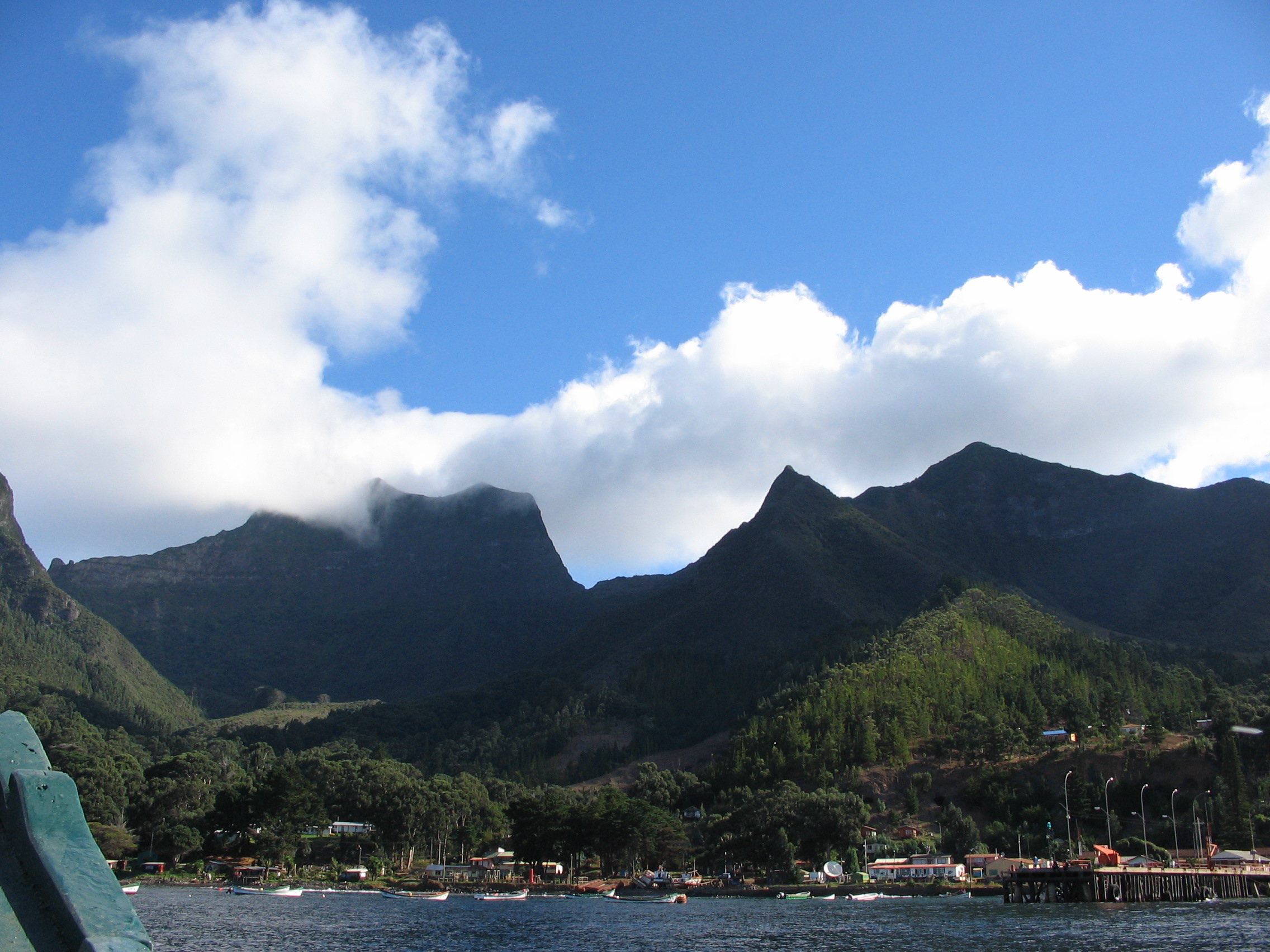
The islands are primarily known for having been the home to the marooned sailor Alexander Selkirk for more than four years from 1704, which may have inspired Daniel Defoe's Robinson Crusoe.[6] Most of the archipelago's present-day inhabitants reside on Robinson Crusoe Island, and mainly in the capital, San Juan Bautista, located at Cumberland Bay on the island's north coast.[7]
The group of islands is part of Chile's Valparaíso Region (which also includes Easter Island) and, along with the Desventuradas Islands, forms one of the nine communes of Valparaíso Province. The islands are named after Juan Fernández, the explorer who discovered them in the 1570s.
Geography

- Robinson Crusoe Island (33°38′00″S 78°51′00″W), also known as Isla Más a Tierra, is located closest to the mainland of continental South America, and is surrounded by a number of islets, including Juanango, Viñilla, Los Chamelos, Los Claveles and El Verdugo.
- Santa Clara (33°42′07″S 79°00′05″W), lying 1 km (0.6 mi) southwest of Robinson Crusoe.
- Alejandro Selkirk Island (33°46′00″S 80°47′00″W), also known as Isla Más Afuera, is located 180 km (112 mi) further west.
Alejandro Selkirk is the largest of the Juan Fernández Islands at 49.5 km2 (19.1 sq mi), and its highest peak, Cerro de Los Inocentes, is also the highest point of the archipelago at 1,268 m (4,160 ft). The island's population was 57 in 2012. Robinson Crusoe is the second largest island in the archipelago at 47.9 km2 (18 sq mi); its highest peak, El Yunque, is 915 m (3,002 ft). The population of Robinson Crusoe was 843 in 2012. Santa Clara is 2.2 km2 (0.8 sq mi) in area and reaches a height of 375 m (1,230 ft). Santa Clara is uninhabited.[8] The maximum elevations of Juan Fernández, 915 m (3,002 ft) for Robinson Crusoe and 1,329 m (4,360 ft) for Alejandro Selkirk, respectively, are high enough to cause the phenomenon known as Kármán vortex street, which can be seen from space.
The islands are volcanic in origin, produced by the movement of the Nazca Plate over the Juan Fernández hotspot. As the plate moved eastward over the hot spot, volcanic eruptions formed the Juan Fernández Ridge before being subducted under the South American continent at the Peru–Chile Trench. The islands occur where the peaks of the submarine ridge have protruded above sea level. Radiometric dating indicates that Santa Clara is the oldest of the islands, at 5.8 million years old, followed by Robinson Crusoe, 3.8 – 4.2 million years old, and Alexander Selkirk, 1.0 – 2.4 million years old.
The seafloor around Juan Fernández Islands is rich in Manganese–Iron nodules, which might be of potential economic interest.[9]
Some consider the islands to be one of the easternmost points of Oceania, rather than an outlying region of South America.[10][11] In their book Shore Fishes of Easter Island, authors John E. Randall and Alfredo Cea Egana claim that the Juan Fernández Islands have "great similarity in ichthyofauna with Oceania more so than with the nearing South America."[12]
Climate
The islands have a subtropical Mediterranean climate,[13] moderated by the cold Humboldt Current, which flows northward to the east of the islands, and the southeast trade winds. Temperatures range from 10 °C (50 °F) to 22 °C (72 °F), with an annual mean of 15.4 °C (60 °F). Higher elevations are generally cooler, with occasional frosts on Robinson Crusoe.
Average annual precipitation is 1,081 mm (42.6 in), varying from 318 mm (12.5 in) to 1,698 mm (66.9 in) year to year. Much of the variability in rainfall depends on the El Niño-Southern Oscillation. Rainfall is higher in the winter months, and varies with elevation and exposure; elevations above 500 m (1,640 ft) experience almost daily rainfall, while the western, leeward side of Robinson Crusoe and Santa Clara are quite dry.
| Climate data for Juan Fernández Islands (1981-2010, extremes 1958-present) | |||||||||||||
|---|---|---|---|---|---|---|---|---|---|---|---|---|---|
| Month | Jan | Feb | Mar | Apr | May | Jun | Jul | Aug | Sep | Oct | Nov | Dec | Year |
| Record high °C (°F) | 28.8 (83.8) |
27.8 (82.0) |
27.0 (80.6) |
26.0 (78.8) |
24.8 (76.6) |
22.2 (72.0) |
22.6 (72.7) |
24.4 (75.9) |
21.8 (71.2) |
23.5 (74.3) |
25.2 (77.4) |
26.9 (80.4) |
28.8 (83.8) |
| Average high °C (°F) | 21.5 (70.7) |
21.4 (70.5) |
21.1 (70.0) |
19.3 (66.7) |
17.6 (63.7) |
16.2 (61.2) |
15.0 (59.0) |
14.8 (58.6) |
15.0 (59.0) |
16.0 (60.8) |
17.6 (63.7) |
19.8 (67.6) |
17.9 (64.2) |
| Daily mean °C (°F) | 18.5 (65.3) |
18.5 (65.3) |
18.1 (64.6) |
16.5 (61.7) |
15.0 (59.0) |
13.6 (56.5) |
12.5 (54.5) |
12.2 (54.0) |
12.3 (54.1) |
13.3 (55.9) |
14.8 (58.6) |
16.9 (62.4) |
15.2 (59.4) |
| Average low °C (°F) | 16.4 (61.5) |
16.6 (61.9) |
16.1 (61.0) |
14.6 (58.3) |
13.1 (55.6) |
11.8 (53.2) |
10.8 (51.4) |
10.4 (50.7) |
10.4 (50.7) |
11.3 (52.3) |
12.7 (54.9) |
14.7 (58.5) |
13.2 (55.8) |
| Record low °C (°F) | 10.6 (51.1) |
4.2 (39.6) |
9.0 (48.2) |
4.2 (39.6) |
4.6 (40.3) |
4.8 (40.6) |
5.0 (41.0) |
3.0 (37.4) |
5.0 (41.0) |
6.2 (43.2) |
7.3 (45.1) |
9.2 (48.6) |
3.0 (37.4) |
| Average rainfall mm (inches) | 32.5 (1.28) |
34.5 (1.36) |
60.3 (2.37) |
91.1 (3.59) |
160.8 (6.33) |
180.1 (7.09) |
160.2 (6.31) |
126.3 (4.97) |
87.7 (3.45) |
54.1 (2.13) |
35.1 (1.38) |
24.1 (0.95) |
1,046.8 (41.21) |
| Average rainy days (≥ 1.0 mm) | 5.6 | 6.1 | 8.8 | 11.2 | 14.6 | 16.4 | 15.9 | 13.5 | 11.1 | 8.3 | 6.0 | 5.4 | 123.0 |
| Average relative humidity (%) | 73 | 73 | 73 | 77 | 78 | 78 | 79 | 77 | 77 | 76 | 74 | 73 | 76 |
| Mean monthly sunshine hours | 248.0 | 209.1 | 158.1 | 123.0 | 108.5 | 99.0 | 93.0 | 105.4 | 147.0 | 204.6 | 249.0 | 260.4 | 2,005.1 |
| Source 1: Dirección Meteorológica de Chile[14][15] | |||||||||||||
| Source 2: World Meteorological Organization (precipitation days 1981–2010),[16] Climate and Temperature (humidity and sun)[17] | |||||||||||||
Biota and ecology
This section needs additional citations for verification. (November 2011) |
The Juan Fernández islands are home to a high percentage of rare and endemic plants and animals, and are recognized as a distinct ecoregion. The volcanic origin and remote location of the islands meant that the islands' flora and fauna had to reach the archipelago from far across the sea; as a result, the island is home to relatively few plant species and very few animal species. The closest relatives of the archipelago's plants and animals are found in the Temperate broadleaf and mixed forests ecoregions of southern South America, including the Valdivian temperate rain forests, Magellanic subpolar forests, and Desventuradas Islands.
Flora
There are 209 native species of vascular plants in the Juan Fernandez Islands, approximately 150 of which are flowering plants, and 50 are ferns. There are 126 species (62 percent) that are endemic, with 12 endemic genera and two endemic families, Lactoridaceae and Thyrsopteridaceae. Many plants are characteristic of the Antarctic flora, and are related to plants found in southern South America, New Zealand and Australia. Vegetation zones generally correspond to elevation, with grasslands and shrublands at lower elevations, tall and montane forests at middle elevations, and shrublands at the highest elevations. The two main islands have somewhat distinct plant communities.
Alejandro Selkirk is mostly covered with grassland from 0 to 400 m (1,300 ft), interspersed with wooded ravines (quebradas), home to dry forests of Myrceugenia and Zanthoxylum fagara. From 400 m (1,300 ft) to 600 m (2,000 ft) are lower montane forests, with upper montane forest from 600 m (2,000 ft) to 950 m (3,100 ft). The treeline is at approximately 950 m (3,100 ft), above which is alpine shrubland and grassland, dominated by temperate Magellanic vegetation such as Acaena, Dicksonia, Drimys, Empetrum, Gunnera, Myrteola, Pernettya, and Ugni. On Robinson Crusoe, grasslands predominate from 0 to 100 m (300 ft); introduced shrubs from 100 m (300 ft) to 300 m (1,000 ft); tall forests from 300 m (1,000 ft) to 500 m (1,600 ft); montane forests from 500 m (1,640 ft) to 700 m (2,300 ft), with dense tree cover of Cuminia fernandezia, Fagara, and Rhaphithamnus venustus; tree fern forests from 700 m (2,300 ft) to 750 m (2,500 ft), and brushwood forests above 750 m (2,500 ft). Santa Clara is covered with grassland.
Three endemic species dominate the tall and lower montane forests of the archipelago, Drimys confertifolia on both main islands, Myrceugenia fernandeziana on Robinson Crusoe, and M. schulzei on Alexander Selkirk. Endemic tree fern species of southern hemisphere genus Dicksonia (D. berteroana on Robinson Crusoe and D. externa on Alexander Selkirk) and the endemic genus Thyrsopteris (T. elegans) are the predominant species in the tree-fern forests. An endemic species of sandalwood, Santalum fernandezianum, was overexploited for its fragrant wood, has not been seen since 1908, and is believed extinct. The Chonta palm (Juania australis), which is endemic to the Juan Fernández Islands, is endangered.
- Maps and satellite images of the islands
 Map of Robinson Crusoe Island (including Santa Clara Island)
 Map of Alejandro Selkirk Island
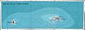 Map of both islands
 Satellite images of Juan Fernández Islands (Alejandro Selkirk Island, inset left)
 overview map


Fauna
The Juan Fernández Islands have a very limited fauna, with no native land mammals, reptiles, or amphibians. Seventeen land and sea-bird species breed on the islands. The island has three endemic bird species, and three endemic subspecies. Introduced fauna by humans include rats and goats. Robinson Crusoe Island is home to an endemic and endangered hummingbird, the Juan Fernández firecrown (Sephanoides fernandensis). This large hummingbird, about 11 cm (4 in) long, is thought to number only about 500 individuals. The other endemic bird species are the Juan Fernández tit-tyrant (Anairetes fernandezianus) of Robinson Crusoe Island, and the Masafuera rayadito (Aphrastura masafuerae) of Alejandro Selkirk Island.[18] The islands support the entire known breeding populations of two petrel species, Stejneger's Petrel Pterodroma longirostris (IUCN status VU) and the Juan Fernandez Petrel Pterodroma externa (IUCN status VU). In addition, the Juan Fernandez Islands may still support a third breeding petrel species, De Filippi's Petrel Pterodroma defilippiana (IUCN status VU), whose only other known breeding grounds are on the Desventuradas Islands. The Magellanic penguin breeds on Robinson Crusoe Island within the archipelago.[19] All three islands of the Juan Fernandez archipelago have been recognised as Important Bird Areas (IBAs) by BirdLife International.[20]
The endemic Juan-Fernandez spiny lobster (without claws) lives in the marine waters (Jasus frontalis). The Juan Fernández fur seal (Arctophoca philippii) also lives on the islands. This species was nearly exterminated in the sixteenth to nineteenth century, but it was rediscovered in 1965. A census in 1970 found about 750 fur seals living there. Only two were sighted on the Desventuradas Islands, located some 780 km (485 mi) to the north. The actual population of the Desventuradas may be higher, because the species tends to hide in sea caves. There seems to be a yearly population increase of 16–17 percent.
History
Prehistory
A 2008 report by archaeologists from the Australian National University states that, "a combination of palaeoecology and archaeology in the Juan Fernández Islands showed it was unlikely there had been human activity in the islands before Europeans arrived."[21] Ichthyologists Ingo Hahn and Uwe Römer wrote in 2002, "the geographically isolated Juan Fernández Islands were probably untouched by man until their discovery by European sailors in 1574. Polynesians did not reach further east than Easter Island and native Americans perhaps not west of the South American continent."[22]
Discovery

The archipelago was discovered on 22 November 1574, by the Spanish sailor Juan Fernández, who was sailing south between Callao and Valparaíso along a route which he also discovered, hundreds of miles west of the coast of Chile, which avoided the northerly Humboldt current. He called the islands Más Afuera, Más a Tierra, and Santa Clara.[23]
In the 17th and 18th centuries, the islands were used as a hideout for pirates and became the location of a penal colony. It was during this period that Alexander Selkirk became marooned on the islands. In the 1740s, they were visited by Commodore Anson's flotilla during his ill-fated venture to the South Seas. The location of the archipelago was fixed by Alessandro Malaspina in 1790; previous charts had differed on the location.[24] British and American whaling vessels were regular visitors to the islands, starting with the London (Captain Joshua Coffin) in 1795.[25]
During the maritime fur trade era of the early 19th century the islands were a source of fur seal skins, and the Juan Fernández fur seal was nearly driven to extinction. In his book Two Years Before the Mast (Chapter VII), Richard Henry Dana, Jr. described the islands as he found them circa 1834. At this time the main island was being used as a penal colony. However, when Dr John Coulter visited the penal colony in the early 1840s, he reported it deserted after the convicts had risen up and killed the soldiers who had held them captive. The prisoners fled to mainland Chile, where they were later hunted down and shot. The story appears in Coulter's book Adventures in the Pacific (1845). In 1908, the islands were visited by the Swedish Magellanic Expedition and Carl Skottsberg is believed to have been the last to have seen the Santalum fernandezianum tree alive.

Late in 1914 the islands were the rendezvous for Admiral Maximilian von Spee's East Asiatic Squadron as he gathered his ships together before defeating the British under Admiral Christopher Cradock at the Battle of Coronel. Following the Royal Navy's win at the Battle of the Falkland Islands a month later, the only surviving German cruiser, SMS Dresden, was hunted down and cornered illegally at Más a Tierra early in 1915, although she was in Chilean territorial waters, where it was scuttled after a brief battle with British cruisers.[26]
In 1966 the Chilean government renamed Más Afuera as Alejandro Selkirk Island and Más a Tierra as Robinson Crusoe Island, in order to promote tourism. Incidentally, Selkirk never set foot on Más Afuera, only on Más a Tierra. On 30 July 2007, a constitutional reform gave the Juan Fernández Islands and Easter Island the status of "special territories" of Chile. Pending the enactment of a charter the archipelago will continue to be governed as a commune of the Valparaíso Region.[27]
On 27 February 2010, a tsunami following the 8.8 magnitude earthquake off Maule, Chile struck the islands causing at least 8 deaths.[28] Eleven people were reported as missing.[29] Some early reports described the tsunami as being 40 m (130 ft) high, but later reports measured it at 3 m (10 ft). Most of the town of San Juan Bautista on Robinson Crusoe Island was destroyed.[30][31][32]
Government
As a commune, the Juan Fernández Islands are a third-level administrative division of Chile governed by a municipal council, headed by a mayor (Spanish: alcalde) who is directly elected every four years. The current mayor for the term 2021–2024 is Pablo Andrés Manríquez Angulo.
Within the electoral divisions of Chile, the commune was represented in the Chamber of Deputies by Joaquín Godoy (RN) and Aldo Cornejo (PDC) as part of the 13th electoral district, together with Valparaíso and Easter Island. It was represented in the Senate by Francisco Chahuán Chahuán (RN) and Ricardo Lagos Weber (PPD) as part of the 6th senatorial constituency (Valparaíso-Coast).
Travel
The islands are served by Robinson Crusoe Airfield, located on Robinson Crusoe Island.
See also
- Endemic fauna of the Juan Fernández Islands
- Endemic flora of the Juan Fernández Islands
- Flora of the Juan Fernández Islands
References
- "Isla Robinson Crusoe". Commune Juan Fernández (2010). Retrieved 8 August 2010.
- "Censos de poblacion y vivienda". Instituto Nacional de Estadísticas (2012). Retrieved 2 January 2013.
- Santibáñez, H.T., Cerda, M.T. (2004). Los parques nacionales de Chile: una guía para el visitante. Colección Fuera de serie. Editorial Universitaria. ISBN 9789561117013
- "Chile Time" Archived 11 September 2007 at the Wayback Machine. World Time Zones (2007). Retrieved 5 May 2007.
- "Chile Summer Time" Archived 11 September 2007 at the Wayback Machine. World Time Zones (2007). Retrieved 5 May 2007.
- Severin, Tim (2002). In Search of Robinson Crusoe. New York: Basic Books. pp. 17–19. ISBN 978-046-50-7699-4.
- The islands' area and population data retrieved from the 2012 census.
- Santibáñez, H. T.; Cerda, M. T. (2004). Los parques nacionales de Chile: una guía para el visitante. Santiago de Chile: Editorial Universitaria. ISBN 978-956-11-1701-3.
- García, Marcelo; Correa, Jorge; Maksaev, Víctor; Townley, Brian (31 January 2020). "Potential mineral resources of the Chilean offshore: an overview". Andean Geology. 47 (1): 1–13. doi:10.5027/andgeoV47n1-3260. S2CID 211550478.
- Thomson, Lex; Doran, John; Clarke, Bronwyn (2018). Trees for life in Oceania: Conservation and utilisation of genetic diversity (PDF). Canberra, Australia: Australian Center for International Agricultural Research. p. 16. Retrieved 24 January 2022.
In a number of cases, human exploitation of certain high-value tree species, including sandalwoods and other highly prized timbers, has led to their extinction—such as the sandalwood species Santalum fernandezianum, in Juan Fernández Islands; and others to the brink of extinction, such S. boninensis in Ogasawara Islands, Japan; or is an ongoing threatening factor in the examples of S. yasi in Fiji and Tonga, Gyrinops spp. in Papua New Guinea (PNG) and Intsia bijuga throughout the Pacific Islands.
- Dahl, Arthur L. (1986). Review of the protected areas system in Oceania. ISBN 978-2-88032-509-1.[page needed]
- Pequeño, Germán (2011). "Shore Fishes of Easter Island, John E. Randall & Alfredo Cea Egaña". Gayana. 75 (2): 201–202. doi:10.4067/S0717-65382011000200011. ProQuest 920291064.
- "Parque Nacional Archipiélago de Juan Fernández" Archived 23 August 2012 at the Wayback Machine. Corporacion Nacional Forestal de Chile (2010). Retrieved 27 May 2010.
- "Datos Normales y Promedios Históricos Promedios de 30 años o menos" (in Spanish). Dirección Meteorológica de Chile. Retrieved 7 December 2018.
- "Temperatura Histórica de la Estación Juan Fernández, Estación Meteorológica. (330031)" (in Spanish). Dirección Meteorológica de Chile. Retrieved 7 December 2018.
- "World Meteorological Organization Climate Normals for 1981–2010". World Meteorological Organization. Archived from the original on 9 October 2021. Retrieved 9 October 2021.
- "San Juan Bautista, Robinson Crusoe Island, Juan Fernández Islands Weather Averages". Climate and Temperature (2013). Retrieved 9 March 2013.
- "Gonzalez J. (2014). Phylogenetic position of the most endangered Chilean bird: the Masafuera Rayadito (Aphrastura masafuerae; Furnariidae). Tropical Conservation Science. 7:677–689" (PDF).
- Hogan, C. Michael (2008) "Magellanic Penguin". Global Twitcher. Retrieved 5 March 2010.
- "Islas Robinson Crusoe and Santa Clara". BirdLife Data Zone. BirdLife International. 2021. Retrieved 22 January 2021.
- Flett, Iona; Haberle, Simon (2008). "East of Easter: Traces of human impact in the far-eastern Pacific" (PDF). In Clark, Geoffrey; Leach, Foss; O'Connor, Sue (eds.). Islands of Inquiry. ANU Press. pp. 281–300. CiteSeerX 10.1.1.593.8988. hdl:1885/38139. ISBN 978-1-921313-89-9. JSTOR j.ctt24h8gp.20.
- https://www.neotropicalbirdclub.org/wp-content/uploads/2020/06/Cotinga-17-2002-66-72.pdf [bare URL PDF]
- Brand, Donald D. (1967). The Pacific Basin: A History of its Geographical Explorations. New York: The American Geographical Society. p. 127.
- Kendrick, John (2003). Alejandro Malaspina: Portrait of a Visionary. Montreal, Quebec: McGill-Queen's Press. p. 46. ISBN 0-7735-2652-8.
- Robert Langdon (ed.) Where the whalers went: an index to the Pacific ports visited by American whalers (and some other ships) in the 19th century, Canberra, Pacific Manuscripts Bureau, 1984, p.124. ISBN 0-86784-471-X
- "El Crucero Alemán Dresden". Commune Juan Fernández (2010). Retrieved 8 August 2010.
- "Chilean Law 20,193". National Congress of Chile (2007).
- Harrell, Eben (2 March 2010). "Chile's President: Why Did Tsunami Warnings Fail?". Time Magazine. Retrieved 4 March 2010.
- Gutierrez, Thelma (27 February 2010). "First Waves of Tsunami Arrive at Hawaii". CNN. Retrieved 27 February 2010.
- Spinali, Gwen (27 February 2010). "40 Meter Tsunami Wave Smashes Juan Fernández Island". Hollywood Backstage. Retrieved 27 February 2010.
- Unravelling the Chilean Tsunami Archived 5 March 2010 at the Wayback Machine. Times Online (1 March 2010). Retrieved 1 March 2010.
- "Forty-Meter Tsunami Wave Hits Juan Fernández Island". Newsolio (27 February 2010). Retrieved 27 February 2010
External links
- Commune Juan Fernández official government website (in Spanish)
- "Images of the Juan Fernández Islands" by W. Schipper in Travel Images
- "Map of Chili" by S. Augustus Mitchell (1860) from the World Digital Library
- "Menaces et perspectives pour la préservation de la biodiversité de l'Archipel Juan Fernández (Chili)" by J. Vanhulst (2009) on preserving the islands' biodiversity (in French)
< Communes and municipalities in Valparaíso Region > | ||
|---|---|---|
| Petorca |  | |
| Los Andes |
| |
| San Felipe de Aconcagua |
| |
| Quillota | ||
| Valparaíso |
| |
| San Antonio | ||
| Isla de Pascua | ||
| Marga Marga | ||
Authority control | |
|---|---|
| General |
|
| National libraries | |
На других языках
[de] Juan-Fernández-Inseln
Die Juan-Fernández-Inseln (auch: Juan-Fernández-Archipel) sind eine zu Chile gehörende Inselgruppe im südlichen Pazifik. Die Inseln sind vulkanischen Ursprungs und liegen zwischen 601 km (Isla Robinson Crusoe) und 747 km (Isla Alejandro Selkirk) westlich des chilenischen Festlandes, etwa auf der geographischen Breite der chilenischen Hafenstadt Valparaíso.- [en] Juan Fernández Islands
[es] Archipiélago Juan Fernández
El archipiélago Juan Fernández es un conjunto de islas ubicado en el Pacífico Sur, a más de 670 km al oeste de las costas de América del Sur. Lo componen las islas Robinson Crusoe (conocida hasta 1966 como Más a Tierra), Alejandro Selkirk (conocida hasta 1966 como Más Afuera), el islote Santa Clara e islotes menores. El archipiélago forma parte del territorio de Chile y administrativamente pertenece a la provincia y Región de Valparaíso. Las Islas son famosas por la novela Robinson Crusoe, escrita por el inglés Daniel Defoe.[fr] Archipel Juan Fernández
L'archipel Juan Fernández est un archipel du Chili situé à environ 675 kilomètres au large des côtes sud-américaines, dans l'Est de l'océan Pacifique sud. L'île Alejandro Selkirk, la plus occidentale, est à une distance de 747 km à l'ouest-nord-ouest des côtes chiliennes de la région du Biobio (Concepción), tandis que la plus orientale, l'île Robinson Crusoe, se trouve à 602 km des rives de la région du Maule. Administrativement, l'archipel fait partie de la région de Valparaíso et constitue l'une des neuf municipalités de la province.[it] Isole Juan Fernández
Le isole Juan Fernández sono un arcipelago al largo delle coste del Cile, costituito dall'isola Robinson Crusoe (fino al 1966 chiamata Más a Tierra), l'isola Alexander Selkirk (fino al 1966 chiamata Más Afuera) e l'isoletta Santa Clara, più alcuni altri isolotti minori.[ru] Хуан-Фернандес
Хуа́н-Ферна́ндес (исп. Archipiélago Juan Fernández) — группа островов в составе Чили, расположенная в юго-восточной части Тихого океана примерно в 670 км к западу от побережья Америки на широте Сантьяго.Другой контент может иметь иную лицензию. Перед использованием материалов сайта WikiSort.org внимательно изучите правила лицензирования конкретных элементов наполнения сайта.
WikiSort.org - проект по пересортировке и дополнению контента Википедии