geo.wikisort.org - Island
Clipperton Island (French: Île de Clipperton or Île de la Passion; Spanish: Isla de la Pasión) is an uninhabited, 6 km2 (2.3 sq mi) coral atoll in the eastern Pacific Ocean. It is 10,677 km (6,634 mi) from Paris, France, 5,400 km (2,900 nmi) from Papeete, Tahiti, and 1,080 km (580 nmi) from Mexico. It is an overseas state private property of France under direct authority of the Minister of the Overseas.[1][2] In the past, Clipperton Island was the subject of a sovereignty dispute in particular between France and Mexico, which was finally settled through arbitration in 1931; the Clipperton Island Case remains widely studied in international law textbooks.[3][4]
Native name: | |
|---|---|
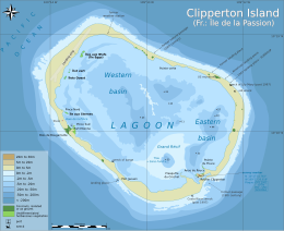 Clipperton Atoll with lagoon with depths (metres) | |
 Clipperton | |
| Geography | |
| Location | Pacific Ocean |
| Coordinates | 10°18′N 109°13′W |
| Archipelago | Lagoon |
| Area | 6 km2 (2.3 sq mi) |
| Highest elevation | 29 m (95 ft) |
| Highest point | Clipperton Rock |
| Administration | |
France | |
| State private property | Île de Clipperton |
| Demographics | |
| Population | 0 (1945) |
| Additional information | |
| Time zone |
|
| Official website | L’île de Clipperton |
| This article is part of a series on the |
| Administrative divisions of France |
|---|
 |
| Administrative divisions |
|
| Intercommunality |
|
| Communes |
|
| Overseas France |
|
| Geocodes of France |
|
|
|
Geography
| area | |
|---|---|
| land | 2 km2 (0.77 sq mi) |
| land + lagoon | 6 km2 (2.3 sq mi) |
| EEZ | 431,273 km2 (166,515 sq mi) |
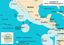
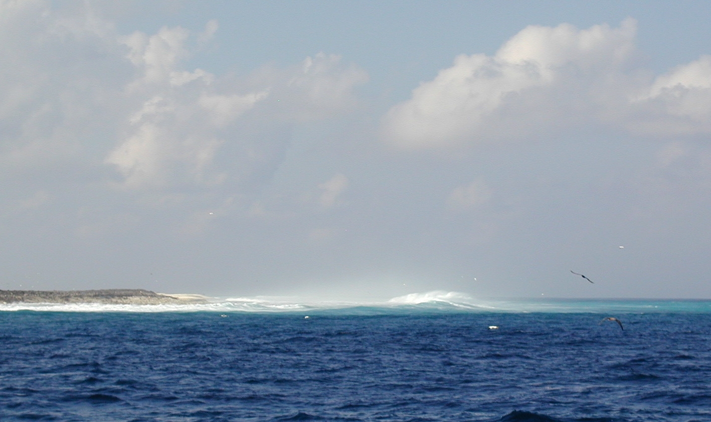
The atoll is 1,080 km (583 nmi) south-west of Mexico, 2,424 km (1,309 nmi) west of Nicaragua, 2,545 km (1,374 nmi) west of Costa Rica and 2,260 km (1,220 nmi) north-west of the Galápagos Islands, Ecuador, at 10°18′N 109°13′W. Clipperton is about 945 km (510 nmi) south-east of Socorro Island in the Revillagigedo Archipelago, which is the nearest land, while the nearest French-owned island is Hiva Oa. Some consider it to be one of the eastern-most points of Oceania, rather than an outlying island of the Americas.[5][6][7][8][9][10][11][12]
It is low-lying and largely barren, with some scattered grasses, and a few clumps of coconut palms (Cocos nucifera). Land elevations average 2 m (6.6 ft), though a small volcanic outcrop rising to 29 m (95 ft) on its south-east side is considerably higher and is referred to as 'Clipperton Rock'.[13] The surrounding reef is exposed at low tide.[14] The presence of this rock means that technically Clipperton is not an atoll but an island with a barrier reef.[citation needed]
Clipperton has had no permanent inhabitants since 1945. It is visited on occasion by fishermen, French Navy patrols, scientific researchers, film crews, and shipwreck survivors. It has become a popular site for transmissions by amateur radio operators.[15]
Environment
Lagoon and climate
Clipperton is a ring-shaped atoll, which completely encloses a stagnant fresh water lagoon, and is 12 km (7.5 mi) in circumference. The lagoon is devoid of fish, and contains some deep basins, with depths of 43 and 72 m (141 and 236 ft), including a spot known as Trou-Sans-Fond, or 'the bottomless hole', with acidic water at its base. The water is described as being almost fresh at the surface, and highly eutrophic. Seaweed beds cover approximately 45 percent of the lagoon's surface. The rim averages 150 m (490 ft) in width, reaching 400 m (1,300 ft) in the west, and narrows to 45 m (148 ft) in the north-east, where sea waves occasionally spill over into the lagoon.[14]
While some sources have rated the lagoon water as non-potable,[16][17] testimony from the crew of the tuna clipper M/V Monarch, stranded for 23 days in 1962 after their boat sank, indicates otherwise. Their report reveals that the lagoon water, while not tasting very good, was drinkable, though "muddy and dirty". Several of the castaways drank it, with no apparent ill effects.[18]
Survivors of an ill-fated Mexican military colony in 1917 (see below) indicated that they were dependent upon rain for their water supply, catching it in old boats they used for this purpose.[18] Aside from the lagoon and water caught from rain, no other freshwater sources are known to exist.
It has a tropical oceanic climate, with average temperatures of 20–32 °C (68–90 °F). The rainy season occurs from May to October, when it is subject to tropical storms and hurricanes. Surrounding ocean waters are warm, pushed by equatorial and counter-equatorial currents. It has no known natural resources (its guano having been depleted early in the 20th century). Although 115 species of fish have been identified in nearby waters, the only economic activity in the area is tuna fishing.
Flora and fauna

When Snodgrass and Heller visited in 1898, they reported that "no land plant is native to the island".[19] Historical accounts from 1711, 1825, and 1839 show a low grassy or suffrutescent (partially woody) flora. During Sachet's visit in 1958, the vegetation was found to consist of a sparse cover of spiny grass and low thickets, a creeping plant (Ipomoea spp.), and stands of coconut palm. This low-lying herbaceous flora seems to be a pioneer in nature, and most of it is believed to be composed of recently introduced species. Sachet suspected that Heliotropium curassavicum, and possibly Portulaca oleracea were native. Coconut palms and pigs were introduced in the 1890s by guano miners. The pigs reduced the crab population, which in turn allowed grassland to gradually cover about 80 percent of the land surface.[20] The elimination of these pigs in 1958, the result of a personal project by Kenneth E. Stager,[21] has caused most of this vegetation to disappear, as the population of land crabs (Johngarthia planata) has returned to millions.[22] The result is virtually a sandy desert, with only 674 palms counted by Christian Jost during the 'Passion 2001' French mission, and five islets in the lagoon with grass that the terrestrial crabs cannot reach.

On the north-west side, the most abundant plant species are Cenchrus echinatus, Sida rhombifolia, and Corchorus aestuans. These plants compose a shrub cover up to 30 cm (12 in) in height, and are intermixed with Eclipta, Phyllanthus, and Solanum, as well as a taller plant, Brassica juncea. A unique feature is that the vegetation is arranged in parallel rows of species, with dense rows of taller species alternating with lower, more open vegetation. This was assumed to be a result of the phosphate mining method of trench-digging.[14]
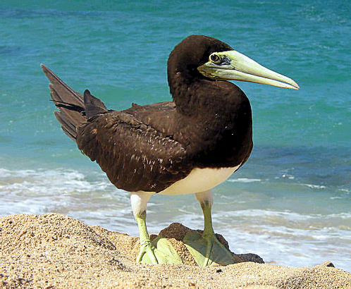
The only land animals known to exist are two species of reptiles (Gehyra insulensis, a gecko, and Emoia cyanura, a skink),[23] bright-orange land crabs (Johngarthia planata, sometimes known as the 'Clipperton Crab', although it is also found on other islands in the eastern Pacific), birds, and rats. The rats probably arrived on large fishing boats that were wrecked on the island in 1999 and 2000.[21] Bird species include white terns, masked boobies, sooty terns, brown boobies, brown noddies, black noddies, great frigatebirds, coots, martins (swallows), cuckoos, and yellow warblers. Ducks have been reported in the lagoon.[14] The island has been identified as an Important Bird Area by BirdLife International because of the large breeding colony of masked boobies, with 110,000 individual birds recorded.[24] The lagoon harbours millions of isopods, which are said to deliver an especially painful sting.[25]
A 2005 report by the National Oceanic and Atmospheric Administrations (NOAA) Southwest Fisheries Science Center indicated that the increased rat presence had led to a decline in both crab and bird populations, causing a corresponding increase in both vegetation and coconut palms. This report urgently recommended eradication of rats, so that vegetation might be reduced, and the island might return to its 'pre-human' state.[21]
History
Discovery and early claims

The island is believed to have been discovered by Spaniard Alvaro Saavedra Cerón on 15 November 1528.[26][27] The expedition was commissioned by Hernán Cortés, the Spanish Conquistador in Mexico, to find a route to the Philippines. Others claim that Portuguese-born Spanish explorer Ferdinand Magellan was the first to find it in 1521,[28][29] which would make Clipperton and certain islands of Micronesia the first areas of the Pacific to be reached by Europeans.[7]
The island was rediscovered on Good Friday, 3 April 1711, by Frenchmen Martin de Chassiron and Michel Du Bocage, commanding the French ships La Princesse and La Découverte. It was given the name Île de la Passion (Passion Island); the date of rediscovery fell within Passiontide. They drew up the first map, and claimed the island for France. The first scientific expedition took place in 1725, under Frenchman M. Bocage, who lived on the island for several months.[30] In 1858, France formally laid claim.[31]
The current name comes from John Clipperton, an English pirate and privateer who fought the Spanish during the early 18th century, and who is said to have passed by the island. Some sources claim that he used it as a base for his raids on shipping.[32]
Other claimants included the United States, whose American Guano Mining Company claimed it under the Guano Islands Act of 1856; Mexico also claimed it due to activities undertaken there as early as 1848–1849. On 17 November 1858 Emperor Napoleon III annexed it as part of the French colony of Tahiti. This did not settle the ownership question. On 24 November 1897, French naval authorities found three Americans working for the American Guano Company, who had raised the American flag. U.S. authorities denounced their act, assuring the French that they did not intend to assert American sovereignty.[33][34] Mexico reasserted its claim late in the 19th century, and on 13 December 1897 sent the gunboat La Demócrata to occupy and annex it. A colony was established, and a series of military governors was posted, the last one being Ramón Arnaud (1906–1916).
Guano mining, Mexican colony, and evacuation of 1917
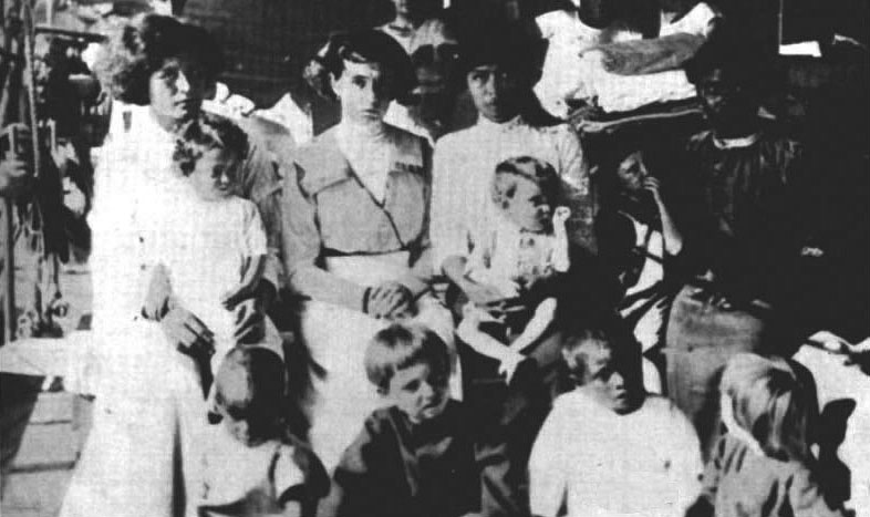
The British Pacific Island Company acquired the rights to guano deposits in 1906, and built a mining settlement in conjunction with the Mexican government. That same year, a lighthouse was erected, under the orders of President Porfirio Díaz. By 1914, around 100 people; men, women, and children, were living there, resupplied every two months by a ship from Acapulco. With the escalation of fighting in the Mexican Revolution, the regular resupply visits ceased, and the inhabitants were left to their own devices.[35]
By 1917, all but one of the male inhabitants had died. Many had perished from scurvy, while others (including Captain Arnaud) died during an attempt to sail after a passing ship to fetch help. Lighthouse keeper Victoriano Álvarez was the last man on the island, together with 15 women and children.[36] Álvarez proclaimed himself 'king', and began a campaign of rape and murder, before being killed by Tirza Rendón, who was his favourite victim. Almost immediately after Álvarez's death, four women and seven children, the last survivors, were picked up by the US Navy gunship Yorktown on 18 July 1917.[35] No more attempts were made to colonise it, though it was briefly occupied during the 1930s and 1940s.[37]
The story of the Mexican colony has been the subject of several novels, including Ivo Mansmann's Clipperton, Schicksale auf einer vergessenen Insel ('Clipperton, Destinies on a Forgotten Island') in German,[38] Colombian writer Laura Restrepo's La Isla de la Pasión ('Passion Island') in Spanish,[39] and Ana García Bergua's Isla de Bobos ('Island of Fools'), also in Spanish.[40]
The history of the island and of Captain Ramón Arnaud was written by his niece Gabriela Arnaud; Clipperton, Una Historia de Honor y Gloria ('Clipperton, A History of Honour and Glory') in Spanish.[41]
Final arbitration of ownership
France insisted on its ownership, and a lengthy diplomatic correspondence between Mexico and France led to the conclusion of a treaty on 2 March 1909, to seek binding international arbitration by King Victor Emmanuel III of Italy, with each nation promising to abide by his determination.[42][43]
In 1931, King Victor Emmanuel III issued his arbitral decision in the Clipperton Island Case, declaring Clipperton to be a French possession.[33][44][45][46]
Post-World War II developments
The island was abandoned by the end of World War II, after being briefly occupied by the US from 1944 to 1945. Since then, it has been visited by sports fishermen, patrols of the French Navy, and by Mexican tuna and shark fishermen. There have been infrequent scientific and amateur radio expeditions, and in 1978 Jacques-Yves Cousteau visited with his team of divers and a survivor from the 1917 evacuation, to film a television special called Clipperton: The Island that Time Forgot.[47]
It was visited by ornithologist Ken Stager of the Los Angeles County Museum in 1958. Appalled at the depredations visited by feral pigs upon the island's brown booby and masked booby colonies (reduced to 500 and 150 birds, respectively), Stager procured a shotgun and killed all 58 pigs. By 2003, the booby colonies had 25,000 brown boobies and 112,000 masked boobies, the world's second-largest brown booby colony, and its largest masked booby colony.[21] In 1994, this story inspired Bernie Tershy and Don Croll, both Professors at UCSC's Long Marine Lab to found the non-profit Island Conservation with the mission to prevent extinctions by removing invasive species from islands.
When the independence of Algeria in 1962 threatened French nuclear testing sites in Algeria, the French Ministry of Defence considered Clipperton Island as a possible replacement. This was eventually ruled out, due to the island's hostile climate and remote location. The French explored reopening the lagoon and developing a harbour for trade and tourism during the 1970s, but this too was abandoned. An automatic weather installation was completed on 7 April 1980, with data collected by this station transmitted directly by satellite to Brittany.
In 1981, the Academy of Sciences for Overseas Territories recommended that the island have its own economic infrastructure, with an airstrip and a fishing port in the lagoon. This would mean opening up the lagoon by creating a passage in the atoll rim. For this purpose, an agreement was signed with the French government, represented by the High Commissioner for French Polynesia, whereby the island became French state property. In 1986, a meeting took place regarding the establishment of a permanent base for fishing, between the High Commissioner, and the survey firm for the development and exploitation of the island (SEDEIC). Taking into account the economic constraints, the distance from markets, and the small size of the atoll, nothing apart from preliminary studies was undertaken. All plans for development were abandoned. In the mid-1980s, the French government also began efforts to enlist citizens of French Polynesia to settle on Clipperton; these plans were ultimately abandoned as well.[48]
Castaways
In early 1962, the island provided a home to nine crewmen of the sunken tuna clipper MV Monarch, stranded for 23 days from 6 February to 1 March. They reported that the lagoon water was drinkable, though they preferred to drink water from the coconuts they found. Unable to use any of the dilapidated buildings, they constructed a crude shelter from cement bags and tin salvaged from Quonset huts built by the American military 20 years earlier. Wood from the huts was used for firewood, and fish caught off the fringing reef combined with some potatoes and onions they had saved from their sinking vessel augmented the island's meager supply of coconuts. The crewmen reported that they tried eating bird's eggs, but found them to be rancid, and they decided after trying to cook a 'little black bird' that it did not have enough meat to make the effort worthwhile. Pigs had been eradicated, though the crewmen reported seeing their skeletons around the atoll. The crewmen were eventually discovered by another fishing boat, and rescued by the United States Navy destroyer USS Robison.[18]
In 1988, five Mexican fishermen became lost at sea after a storm during their trip along the coast of Costa Rica. They drifted within sight of the island, but were unable to reach it.[49] Steven Longbaugh and David Heritage, two American deckhands from a fishing boat based in California, were stranded for three weeks in 1998. They were rescued after rebuilding a survival radio, and using distress flares to signal for help.[50][verification needed]
21st century
The Mexican and French oceanographic expedition SURPACLIP (UNAM Mexico and UNC Nouméa) made extensive studies in 1997. In 2001, French geographer Christian Jost extended the 1997 studies through his French 'Passion 2001' expedition, explaining the evolution of the ecosystem, and releasing several papers, a video film, and a website.[51] In 2003, Lance Milbrand[52] stayed for 41 days on a National Geographic Society expedition, recording his adventure in video, photos, and a written diary (see links below).
In 2005, the ecosystem was extensively studied for four months by a scientific mission organised by Jean-Louis Étienne,[53] which made a complete inventory of mineral, plant, and animal species, studied algae as deep as 100 m (328 ft) below sea level, and examined the effects of pollution. A 2008 expedition from the University of Washington's School of Oceanography collected sediment cores from the lagoon, to study climate change over the last millennium.[54]
On 21 February 2007, administration was transferred from the High Commissioner of the Republic in French Polynesia to the Minister of Overseas France.[55]
In 2007, a recreational scuba diving expedition explored the reefs surrounding Clipperton, and compared the marine life with the reports of the Connie Limbaugh (Scripps) expeditions in 1956 and 1958. Recreational scuba diving expeditions are now made every spring.
During the night of 10 February 2010, the Sichem Osprey, a Maltese chemical tanker, ran aground en route from the Panama Canal to South Korea. The 170 m (558 ft) ship contained xylene, a clear, flammable volatile liquid. All 19 crew members were reported safe, and the vessel reported no leaks.[56][57] The vessel was re-floated on 6 March[58] and returned to service.[59]
In mid-March 2012, the crew from the Clipperton Project[60] noted the widespread presence of refuse, particularly on the north-east shore, and around the Rock. Debris, including plastic bottles and containers, create a potentially harmful environment for its flora and fauna. This trash is common to only two beaches (North East and South West), and the rest of the island is fairly clean. Other refuse has been left after occupation by Americans 1944–1945, French 1966–1969, and the 2008 scientific expedition.
Amateur radio DX-peditions
The island has long been an attractive destination for amateur radio groups, due to its remoteness, the difficulty of landing, permit requirements, garish history, and interesting environment. While some radio operation was done ancillary to other expeditions, major DX-peditions include FO0XB (1978), FO0XX (1985), FO0CI (1992), FO0AAA (2000), and TX5C (2008).
One DX-pedition was the Cordell Expedition in March 2013 using the callsign TX5K,[61] organised and led by Robert Schmieder. The project combined radio operations with selected scientific investigations. The team of 24 radio operators made more than 114,000 contacts, breaking the previous record of 75,000. The activity included extensive operation of the 6 meter band, including Earth–Moon–Earth communication (EME) or 'moonbounce' contacts. A notable accomplishment was the use of DXA, a real-time satellite-based online graphic radio log web page, that allowed anyone anywhere with a browser to see the radio activity. Scientific work carried out during the expedition included the first collection and identification of foraminifera, and extensive aerial imaging of the island using kite-borne cameras. The team included two scientists from the French-Polynesian University of Tahiti, and a TV crew from the French documentary television series Thalassa.[62]
An April 2015 DX-pedition using callsign TX5P was conducted by Alain Duchauchoy, F6BFH, concurrent with the Passion 2015 scientific expedition to Clipperton Island, and engaging in research of Mexican use of the island during the early 1900s.[63]
Postal code
The island is assigned with French postal code 98799. However, there is no post office on the island.[64]
See also
- Desert island
- Lists of islands
References
- Article 9 — "Loi n° 55-1052 du 6 août 1955 modifiée portant statut des Terres australes et antarctiques françaises et de l'île de Clipperton" [Law No. 55-1052 of 6 August 1955 on the status of French Southern and Antarctic Lands and Clipperton Island]. LegiFrance.gouv.fr (in French). 6 August 1955.
- "Décret du 31 janvier 2008 relatif à l'administration de l'île de Clipperton" [31 January 1966 Order Respecting the Administration of Clipperton Island]. LegiFrance.gouv.fr (in French). 31 January 2008.
- E.g., Edwin D. Dickinson, "The Clipperton Island Case", The American Journal of International Law, Vol. 27, No. 1 (Jan., 1933), pp. 130-133 (4 pages)
- Mark A. Smith, "Sovereignty Over Unoccupied Territories—The Western Sahara Decision", Case Western Reserve Journal of International Law, Vol. 9, Iss. 1, Pp. 135-159 (1977).
- Fisher, Denise (16 March 2022). "L'Indo-Pacifique et la souveraineté de la France en Océanie". Outre-Terre. 6061 (1): 467–503. doi:10.3917/oute2.060.0468. S2CID 247540315.
- Hinz, Earl R.; Howard, Jim (2006). Landfalls of Paradise: Cruising Guide to the Pacific Islands. University of Hawaii Press. ISBN 9780824845186. Retrieved 4 February 2022 – via Google Books.
French Polynesia operates as a CEPT country under French authority, but still requires local permission and a local call sign (as do the other French colonies in Oceania: Clipperton, New Caledonia, and Wallis and Futuna.
- "Oceania Military Guide". GlobalSecurity.org. Global Security. Retrieved 6 January 2022.
- Todd, Ian (1974). Island Realm: A Pacific Panorama. Angus & Robertson. p. 190. ISBN 9780207127618. Retrieved 2 February 2022 – via Google Books.
On the other side of Oceania, about 1,800 miles (2,897 km) west of the Panama Canal, is another French possession, Clipperton Island.
- Bempéchat, Paul-André (2017). Jean Cras, Polymath of Music and Letters. Taylor & Francis. ISBN 9781351561754. Retrieved 18 February 2022 – via Google Books.
In India, French settlements included Pondicherry, Karikal, Yanaon, Mahé and Chandernagore; and in Oceania, Clipperton, New Caledonia, French Polynesia, Vanuatu (shared with the British Empire)
- Terry, James P. (1988). Climate and Environmental Change in the Pacific. The University of Michigan. p. 5. ISBN 9789820103580. Retrieved 11 March 2022 – via Google Books.
The British added the Ellice, Pitcairn and portions of the Phoenix Islands; the Australians consolidated their claims to Papua; and the French consolidated their claims to Clipperton islands; Easter and adjacent islands were claimed by Chile, Cocos Island was claimed by Costa Rica, and the Galapagos claimed by Ecuador. By 1900, there were virtually no remaining islands in Oceania unclaimed by foreign powers.
- Ineich, Ivan; Zug, George (1991). "Nomenclatural status of Emoia cyanura (Lacertilia, Scincidae) populations in the Central Pacific". Copeia. American Society of Ichthyologists and Herpetologists. 1991 (4): 1132–1136. doi:10.2307/1446114. JSTOR 1446114. Retrieved 18 March 2022.
Its distribution encompasses much of Oceania from the Hawaiian archipelago, Clipperton Island, and Easter Island westward through Polynesia and Melanesia
- Flichy de la Neuville, Thomas; De Gentile, Eleonore (2022). "France in the Pacific. History of a Discreet Presence". Zeitschrift für Außen- und Sicherheitspolitik. 15: 69–82. doi:10.1007/s12399-022-00893-w. S2CID 248174340.
- "Clipperton Island pictures and history". QSL.net. 2000 DXpedition to Clipperton Island.
- "Eastern Pacific Ocean, southeast of Mexico". Terrestrial Ecoregions. World Wildlife Fund. Retrieved 17 June 2012.
- "QSLs and stories from previous DXpeditions". QSL.net. 2000 DXpedition to Clipperton Island. Retrieved 11 January 2018.
- "Clipperton Island". TravelTips24.com. Travel Tips 24. Archived from the original on 5 April 2010. Retrieved 26 April 2010.
- Milbrand, Lance (29 August 2003). "Clipperton Journal: The daily record of life on a Pacific atoll". News.NationalGeographic.com. National Geographic News. Diary of a 2003 visit by Lance Milbrand on NationalGeographic.com
{{cite web}}: CS1 maint: postscript (link) - Atoll Research Bulletin No. 94 (PDF) (Report). Washington, D.C.: National Academy of Sciences. 15 December 1962. pp. 8–10.
- Snodgrass & Heller (1902).
- Sachet, M.H. (7 March 1962). "Flora and vegetation of Clipperton Island". Proceedings of the California Academy of Sciences. 4th. San Francisco, USA: California Academy of Sciences. 31 (10): 249–307. Retrieved 12 January 2018 – via BiodiversityLibrary.org.
- Pitman, Robert L.; Ballance, Lisa T.; Bost, Charly (2005). "Clipperton Island: pigsty, rat hole, and booby prize". Marine Ornithology. 33 (2): 193–194. CiteSeerX 10.1.1.600.7376.
- Davie P (2015). Bieler R, Bouchet P, Gofas S, Marshall B, Rosenberg G, La Perna R, Neubauer TA, Sartori AF, Schneider S, Vos C, ter Poorten JJ, Taylor J, Dijkstra H, Finn J, Bank R, Neubert E, Moretzsohn F, Faber M, Houart R, Picton B, Garcia-Alvarez O (eds.). "Johngarthia planata (Stimpson, 1860)". MolluscaBase. World Register of Marine Species. Retrieved 22 February 2017.
- Zug, George R. (2013). Reptiles and Amphibians of the Pacific Islands: A Comprehensive Guide. University of California Press. p. 45. ISBN 978-0-520-95540-0 – via Google Books.
- "Important Bird Areas factsheet: Clipperton". Datazone.BirdLife.org. BirdLife International. 2018. Retrieved 11 January 2018.
- Goode, Michael. "1992 Clipperton Island expedition". QSL.net. 2000 DXpedition to Clipperton Island. Retrieved 17 June 2012.
- Vargas, Jorge A. (2011). Mexico and the Law of the Sea: Contributions and Compromises. Publications on Ocean Development. Vol. 69. Martinus Nijhoff Publishers. p. 470. ISBN 9789004206205. Retrieved 7 September 2019 – via Google Books.
- Wright, Ione Stuessy (1953). Voyages of Alvaro de Saavedra Cerón 1527–1529. University of Miami Press.
- Pike, John. "Clipperton - history". GlobalSecurity.org. Global Security. Retrieved 6 January 2022.
- Nunn, George E. (1934). "Magellan's Route in the Pacific". Geographical Review. 24 (4): 615–633. doi:10.2307/208851. JSTOR 208851.
- "Clipperton Island". Molossia.org. Retrieved 10 July 2020.
- Pike, John. "Clipperton / Ile de la Passion". GlobalSecurity.org. Global Security. Retrieved 8 February 2018.
- Büch, Boudewijn (2003). Eilanden [Islands] (in Dutch). Netherlands: Singel Pockets. ISBN 978-9-04-133086-4.
- Emmanuel, V. (1932). "Arbitral award on the subject of the difference relative to the sovereignty over Clipperton Island" (PDF). The American Journal of International Law. 26 (2): 390–394. doi:10.2307/2189369. JSTOR 2189369. S2CID 246005364. Archived (PDF) from the original on 9 October 2022.
- Dickinson, Edwin D. (1933). "The Clipperton Island Case". American Journal of International Law. 27 (1): 130–133. doi:10.2307/2189797. ISSN 0002-9300. JSTOR 2189797. S2CID 147177707.
- "About Clipperton Island". ClippertonProject.com. The Clipperton Project. 2014. Archived from the original on 17 January 2014. Retrieved 11 January 2018.
- "Trip report and photos: Clipperton Island – April 10–25, 2010". ElaineJobin.com. Elaine Jobin. Archived from the original on 1 August 2012. Retrieved 17 June 2012.
- "The @mvbrigittebardot drifting in front of Clipperton Island". Picuki.com. Retrieved 31 March 2021.
- Mansmann, Ivo (1990). Clipperton: Schicksale auf einer vergessenen Insel: Roman [Clipperton: Destinies on a forgotten island: A novel] (in German). Halle: Mitteldeutscher Verlag. ISBN 978-3-35-400709-3. OCLC 31495383.
- Restrepo, Laura (1989). La Isla de la Pasión [Passion Island] (in Spanish). Bogotá, Colombia: Planeta. ISBN 978-0-06-081620-9. OCLC 21335043.
- Bergua, Ana Garcia (2007). Isla de Bobos [Booby Island] (in Spanish). Mexico City: Planeta Editorial. ISBN 978-9-70-749064-2. OCLC 180756453.
- Arnaud, Gabriela (2015). Clipperton, Una Historia de Honor y Gloria [Clipperton, A History of Honour and Glory] (in Spanish). Mexico: bubok Editorial. ISBN 978-84-686-8274-7.
- "Original treaty between Mexico and France" (PDF). Pastel.Diplomatie.gouv.fr (in French). French Foreign Ministry Archives. Archived from the original (PDF) on 25 July 2011. Retrieved 19 June 2009.
- Dickinson, Edwin D. (1933). "The Clipperton Island case". The American Journal of International Law. 27 (1): 130–133. doi:10.2307/2189797. JSTOR 2189797. S2CID 147177707.
- "Affaire de l'île de Clipperton (Mexique contre France)" [Case of Clipperton Island (Mexico v. France)] (PDF). Recueil des Sentences Arbitrales [Reports of International Arbitral Awards] (in French). Vol. II. United Nations (published 2006). 28 January 1931. pp. 1105–1111. Archived (PDF) from the original on 9 October 2022.
- John P. Grant; J. Craig Barker, eds. (2009). "Clipperton Island case". Encyclopaedic Dictionary of International Law (3rd ed.). Oxford University Press. doi:10.1093/acref/9780195389777.001.0001. ISBN 978-0-19-538977-7.
- Heflin, William B. (2000). "Diayou / Senkaku islands dispute: Japan and China, Oceans Apart" (PDF). Asian-Pacific Law & Policy Journal. 1 (18): 11–13. Archived from the original (PDF) on 28 September 2010. Retrieved 11 January 2018.
- Rogerson, Simon (19 July 2006). "Cousteau and the Pit". DiveMagazine.co.uk. Dive Magazine. Archived from the original on 15 April 2009. Retrieved 24 June 2008.
- van Dyke, Jon M.; Morgan, Joseph R.; Gurish, Jonathan. "The Exclusive Economic Zone of the Northwestern Hawaiian Islands: When Do Uninhabited Islands Generate an EEZ?". p. 465.
- Arias, Ron (1990). Five against the sea: A true story of courage and survival. Viking. ISBN 978-0-67-083092-3.
- LaJoie, John. American Maritime Accident Report, 1998
- Jost, Christian (2014). "Bienvenue sur l'île de La Passion ... Clipperton!" [Welcome to Passion Island ... Clipperton!] (in French). Retrieved 11 January 2018. Website by Christian Jost, French National Centre for Scientific Research (CNRS) researcher
{{cite web}}: CS1 maint: postscript (link) - Milbrand, Lance. "Lance Milbrand". MilbrandCinema.com. Milbrand Cinema. Retrieved 17 June 2012.
- Étienne, Jean-Louis (2005). "Expédition Clipperton". JeanLouisEtienne.com (in French). Jean-Louis Étienne. Archived from the original on 12 May 2008. Retrieved 23 May 2005. Website of the 2005 scientific mission of Jean-Louis Étienne
{{cite web}}: CS1 maint: postscript (link) - Nelson, Dan; Sachs, Julian (2 April 2008). "Clipperton Atoll Expedition – 2008". Faculty.Washington.edu. School of Oceanography, University of Washington. Retrieved 17 June 2012. Pages of the 2008 expedition by the School of Oceanography, University of Washington
{{cite web}}: CS1 maint: postscript (link) - Cahoon, Ben. "French Minor Dependencies". WorldStatesmen.org.
- "Re: Probe into Sichem Osprey grounding". Diver.net. 1 March 2010. Retrieved 17 June 2012.
- "Xylene tanker runs aground on Clipperton Island". ReefTools.com. 22 February 2010. Retrieved 17 June 2012.
- "Eitzen tanker Sichem Osprey refloated". LloydsList.MaritimeIntelligence.Informa.com. Lloyds List. 8 March 2010. Archived from the original on 12 January 2018. Retrieved 17 June 2012.
- "Sichem Osprey". MarineTraffic.com. 13 June 2012. Retrieved 17 June 2012.
- "Plastic surveying and collection". ClippertonProject.com. The Clipperton Project. 12 March 2012. Archived from the original on 2 May 2012. Retrieved 17 June 2012.
- "Clipperton Island". TX5K.org. 2013 Cordell Expedition. Website of a visit by amateur radio enthusiasts
{{cite web}}: CS1 maint: postscript (link) - Schmieder, Robert W. (15 June 2013). "Report of the Expedition Leader" (PDF). Cordell.org. The 2013 Cordell Expedition to Clipperton Island. Archived (PDF) from the original on 9 October 2022. Retrieved 11 January 2018.
- "TX5P - Clipperton Island - Passion 2015 - News". dxnews.com. 18 April 2015. Retrieved 17 June 2022.
- "Clipperton : une « passion » américano-franco-mexicaine". Le Monde.fr. Le Monde. 17 April 2020. Retrieved 31 July 2022.
Sources
- Allen, G.R.; Robertson, D.R. (1996). "An annotated checklist of the fishes of Clipperton Atoll, tropical eastern Pacific".[permanent dead link]
- "State of coral reefs in Clipperton Island". ReefBase.org. French Coral Reef Initiative (IFRECOR). 1998. Retrieved 11 January 2018.
- Jost, Christian; Andrefouët, S. (2006). "Review of long term natural and human perturbations and current status of Clipperton Atoll, a remote island of the Eastern Pacific". Pacific Conservation Biology. Vol. 12. Chipping Norton, New South Wales, Australia: Surrey Beatty & Sons Pty. Ltd. p. 3.
- Jost, Christian (1 July 2005). "Risques environnementaux et enjeux à Clipperton (Pacifique français)". Revue européenne Cybergeo (in French). 314. Archived from the original on 21 November 2003.
cartes et fig., 15 p.
- Jost, Christian (June–December 2005). "Bibliographie de l'île de Clipperton, île de La Passion (1711–2005)". Journal de la Société des Océanistes (in French). Paris, France. 120–121 (120–121): 181–197. doi:10.4000/jso.481.
texte et 411 réf.
- Pitman, R.L.; Jehl, J.R. (1998). "Geographic variation and reassessment of species limits in the 'masked' boobies of the eastern Pacific Ocean". Wilson Bulletin. 110: 155–170.
- Skaggs, Jimmy (1989). Clipperton. A history of the island the world forgot. New York, NY, USA: Walker and Company.
- Snodgrass, R. E. & Heller, E. (30 September 1902). "The birds of Clipperton and Cocos Islands". Proceedings of the Washington Academy of Sciences. Papers from the Hopkins Stanford Galápagos expedition 1898–1899. IV: 501–520. Retrieved 11 January 2018.
- Tamburini, Francesco (2008). "La controversia tra Francia e Messico sulla sovranità dell'isola di Clipperton e l'arbitrato di Vittorio Emanuele III (1909–1931)". Ricordo di Alberto Aquarone, Studi di Storia (in Italian). Pisa, Italy: Edizioni Plus.
- Central and Western Pacific. UNEP Regional Seas Directories and Bibliographies. Coral Reefs of the World. Vol. 3. Gland, Switzerland; Cambridge, England; Nairobi, Kenya: International Union for Conservation of Nature (IUCN) / United Nations Environment Programme (UNEP). 1988.
External links
 Definitions from Wiktionary
 Media from Commons
 News from Wikinews
 Quotations from Wikiquote
 Texts from Wikisource
 Textbooks from Wikibooks
 Travel information from Wikivoyage
 Resources from Wikiversity
 Wikimedia Atlas of Clipperton Island
- Isla Clipperton o 'Los náufragos mexicanos −1914/1917–' (in Spanish)
Photo galleries
- The first dive trip to Clipperton Island aboard the Nautilus Explorer — pictures taken during a 2007 visit
- Clipperton Island 2008 — Flickr gallery containing 94 large photos from a 2008 visit
- 3D photos of Clipperton Island 2010 — 3D anaglyphs
Visits and expeditions
- 2000 DXpedition to Clipperton Island — website of a visit by amateur radio enthusiasts in 2000
- Diving trips to Clipperton atoll — from NautilusExplorer.com
| |||||||||||||
| |||||||||||||
| |||||||||||||
Earth's primary regions and subregions | |||||||||||||||||||||||||||||||||||||||||||||||||||||
|---|---|---|---|---|---|---|---|---|---|---|---|---|---|---|---|---|---|---|---|---|---|---|---|---|---|---|---|---|---|---|---|---|---|---|---|---|---|---|---|---|---|---|---|---|---|---|---|---|---|---|---|---|---|
| |||||||||||||||||||||||||||||||||||||||||||||||||||||
Authority control | |
|---|---|
| General |
|
| National libraries | |
| Other | |
На других языках
[de] Clipperton-Insel
Die Clipperton-Insel (französisch Île Clipperton oder Île de la Passion) liegt im Pazifischen Ozean etwa 1080 km südwestlich von Mexiko. Sie ist ein unbewohntes Atoll und französisches Überseegebiet.- [en] Clipperton Island
[es] Isla Clipperton
La Isla Clipperton o Isla de la Pasión (en francés: Île de Clipperton o bien Île de la Passion) es un atolón coralino deshabitado de 6 km² de superficie y 11,1 km de línea costera,[1] localizado en el océano Pacífico norte, a 1085 kilómetros de Playa la Llorona en el Municipio de Aquila, Michoacán, México,[1] siendo el punto más cercano a tierra firme. Es una posesión francesa administrada desde la Polinesia Francesa por un alto comisionado de Francia.[2][fr] Île Clipperton
L'île Clipperton[1], aussi appelée île de Clipperton ou simplement Clipperton, autrement dénommée île de la Passion, est une possession française composée d'un unique atoll situé dans l'Est de l'océan Pacifique nord, à 1 081 km au sud-ouest de l'État mexicain du Michoacán, à 2 500 kilomètres au nord-ouest des îles Galápagos[2], à 5 408 kilomètres à l'est-nord-est de Papeete (île de Tahiti) et à 10 666 km à l'ouest-sud-ouest de Paris. Son lagon est le seul d'eau douce au monde[3]. L'île Clipperton est aussi la seule possession française du Pacifique nord[4]. Cette île est le quatrième territoire français du Pacifique et le cinquième de l'Outre-mer français par son extension maritime[5]. Bien que l’île soit un territoire français, elle ne possède aucun statut au sein de l’Union européenne.[it] Clipperton
L'isola di Clipperton, anche chiamata isola della Passione (in francese Île de Clipperton o Île de la Passion, è un atollo francese situato nell'oceano Pacifico, a 1.280 km a ovest del Messico. Le coordinate dell'atollo sono 10°18'N, 109°13'O. Posta prima sotto la giurisdizione dello Stabilimento francese di Oceania nel 1936 poi della Polinesia francese fino al 18 marzo 1986, l'isola fa oggi parte dei possedimenti marittimi pubblici ed è iscritta fra le proprietà demaniali dello Stato e, a questo titolo, sotto l'autorità del Primo Ministro il quale delega all'Alto Commissario della Repubblica della Polinesia francese per permessi come quello di attracco o di concessione di sfruttamento. Clipperton non è quindi formalmente un TOM.[ru] Клиппертон
Клипперто́н (О́стров Стра́сти) (фр. Île de Clipperton или фр. Île de la Passion; исп. Isla Clipperton; англ. Clipperton Island) — коралловый атолл, находящийся в восточной части Тихого океана, к западу от Коста-Рики. Остров принадлежит Франции. Имеет статус — Заморское особое административно-территориальное образование Франции. До 21 февраля 2007 года административно подчинялся Французской Полинезии, теперь управляется непосредственно правительством Франции[1].Другой контент может иметь иную лицензию. Перед использованием материалов сайта WikiSort.org внимательно изучите правила лицензирования конкретных элементов наполнения сайта.
WikiSort.org - проект по пересортировке и дополнению контента Википедии