geo.wikisort.org - Island
The Virgin Islands (Spanish: Islas Vírgenes) are an archipelago in the Caribbean Sea. They are geologically and biogeographically the easternmost part of the Greater Antilles,[1] the northern islands belonging to the Puerto Rico Trench and St. Croix being a displaced part of the same geologic structure. Politically, the British Virgin Islands have been governed as the western island group of the Leeward Islands, which are the northern part of the Lesser Antilles, and form the border between the Caribbean Sea and the Atlantic Ocean. The archipelago is separated from the true Lesser Antilles by the Anegada Passage and from the main island of Puerto Rico by the Virgin Passage.
This article needs additional citations for verification. (September 2021) |
 United States Virgin Islands British Virgin Islands | |
| Geography | |
|---|---|
| Location | Caribbean Sea, Atlantic Ocean |
| Coordinates | 18.2°N 64.8°W |
| Archipelago | Leeward Islands |
United States | |
| Insular area | United States Virgin Islands |
| Insular area | Puerto Rico |
United Kingdom | |
| Overseas territory | British Virgin Islands |
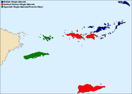
The islands fall into three different political jurisdictions:
- Virgin Islands, informally referred to as British Virgin Islands, a British overseas territory,
- United States Virgin Islands, an unincorporated territory of the United States,
- Spanish Virgin Islands, the easternmost islands of the Commonwealth of Puerto Rico, itself an unincorporated territory of the United States.
Etymology


Christopher Columbus named the islands after Saint Ursula and the 11,000 Virgins (Spanish: Santa Úrsula y las Once Mil Vírgenes), shortened to the Virgins (las Vírgenes). The official name of the British territory is the Virgin Islands, and the official name of the U.S. territory is the Virgin Islands of the United States. In practice, the two island groups are almost universally referred to as the British Virgin Islands and the U.S. Virgin Islands.
History
The Virgin Islands were originally inhabited by the Arawak and Carib, many of whom are thought to have perished during the colonial period due to enslavement, foreign disease, and war brought about by European colonists.[2]
European colonists later settled here and established sugar plantations, at least one tobacco plantation, and purchased people for slavery taken from Africa. The descendants of the enslaved people remain the bulk of the population, sharing a common African-Caribbean heritage with the rest of the English-speaking Caribbean.
Like mainland Puerto Rico, the Virgin Islands that belonged to Spain were ceded to the United States in 1898. The United States took possession of the islands after the signing of the armistice that put an end to military operations in the Spanish–American War.
A 1916 treaty between the United States and Denmark (not ratified by the United States until 1917) resulted in Denmark selling the Danish Virgin Islands to the United States for $25 million in gold.
Historical affiliations
The Virgin Islands have been under the sovereignty of several nations and groups throughout history. Below is a table which represents the affiliation of the various islands:
| present day U.S.V.I. | present day British V.I. | present day Spanish V.I. (P.R.) | |||||||||
|---|---|---|---|---|---|---|---|---|---|---|---|
| St. Thomas | St. John | St. Croix | Tortola | Virgin Gorda | Anegada | Jost Van Dyke | Culebra | Vieques | |||
| New Spain (1493–1625) |
New Spain (1493–1671) |
New Spain (1493–1625) |
New Spain (1493–1648) |
New Spain (1493–1628) |
New Spain (1493–1648) |
New Spain (1493–1750) |
New Spain (1493–1580) |
New Spain (1493–1580) | |||
| Puerto Rico (SP) (1580–1898)* | Puerto Rico (SP) (1580–1689)* | ||||||||||
| Dutch Virgin Islands (1625–1651) | Dutch Virgin Islands (1625–1650)** | Dutch Virgin Islands (1628–1680) | |||||||||
| British Leeward Islands (1625–1650)** | |||||||||||
| British Leeward Islands (1650) | Dutch Virgin Islands (1648–1672) | Dutch Virgin Islands (1648–1680) | |||||||||
| Puerto Rico (SP) (1650) |
|||||||||||
| Danish West Indies (1651–1801) | Knights Hospitaller (1651–1664) | ||||||||||
| French West Indies (1664–1733) | |||||||||||
| Danish West Indies (1671–1684) | British Leeward Islands (1672-1816) | British Leeward Islands (1680-1816) | British Leeward Islands (1680-1816) | Brandenburg-Prussia (1689–1693) | |||||||
| Brandenburg-Prussia (1685–1721)*** | British Leeward Islands (1684–1718) | Puerto Rico (SP) (1693–1698) | |||||||||
| Danish West Indies (1651–1801) | Danish West Indies (1718–1801) | Danish West Indies (1733–1801) | British Leeward Islands (1750–1816) | Scottish Darien Company (1698) | |||||||
| Danish West Indies (1698–1811)** | |||||||||||
| British Leeward Islands (1801–1802) | British Leeward Islands (1801–1802) | British Leeward Islands (1801–1802) | British Leeward Islands (1698–1811)** | ||||||||
| Danish West Indies (1802–1807) | Danish West Indies (1802–1807) | Danish West Indies (1802–1807) | French West Indies (1698–1811)** | ||||||||
| British Leeward Islands (1807–1815) | British Leeward Islands (1807–1815) | British Leeward Islands (1807–1815) | Puerto Rico (SP) (1698–1811)*** | ||||||||
| Danish West Indies (1815–1917) | Danish West Indies (1815–1917) | Danish West Indies (1815–1917) | British Virgin Islands (1816–1833) | British Virgin Islands (1816–1833) | British Virgin Islands (1816–1833) | British Virgin Islands (1816–1833) | Puerto Rico (SP) (1811–1898) | ||||
| British Leeward Islands (1833–1958) | British Leeward Islands (1833–1958) | British Leeward Islands (1833–1958) | British Leeward Islands (1833–1958) | ||||||||
| Puerto Rico (US) (1898–present) | Puerto Rico (US) (1898–present) | ||||||||||
| United States Virgin Islands (1917–present) | United States Virgin Islands (1917–present) | United States Virgin Islands (1917–present) | |||||||||
| British Virgin Islands (1958–present) | British Virgin Islands (1958–present) | British Virgin Islands (1958–present) | British Virgin Islands (1958–present) | ||||||||
*Largely under control of pirates
**Coexisting claim
***Leased/shared territory
Demography
This section does not cite any sources. (January 2019) |
The total population of the Virgin Islands is 147,778: 104,901 in the U.S. Virgin Islands, 31,758 in the British, and 11,119 in the Spanish. Roughly three-quarters of islanders are black in the British and U.S. Virgin Islands, while the majority of inhabitants in Culebra and Vieques are Puerto Rican of European descent, with a significant Afro-Puerto Rican community. The main languages are English and Virgin Islands Creole in the U.S. and British Virgin Islands, and Spanish in the Puerto Rican territory. St. Thomas is the most populous island, with St. Croix close behind (51,634 and 50,601, respectively).
| Name | Sovereign State | Subdivisions | Area (km2) |
Population (2005 est.) |
Population density (per km2) |
Capital |
|---|---|---|---|---|---|---|
| British Virgin Islands | United Kingdom | Districts | 153.0 | 31,758 | 207.6 | Road Town |
| Spanish Virgin Islands (Puerto Rico) | United States | Barrios | 165.1 | 11,119 | 67.3 | San Juan, PR |
| United States Virgin Islands | United States | Districts | 346.4 | 104,901 | 302.8 | Charlotte Amalie |
| Total | 664.5 | 147,778 | 222.4 | |||
Traffic control
Motor vehicles are driven on the left-hand side of the road in both the British and the U.S. Virgin Islands, although the steering wheels on most cars are located on the left side (as is the norm for drive-on-the-right localities). In the Spanish Virgin Islands, vehicles are driven on the right-hand side of the road.
See also
- Culture of the Virgin Islands
- Danish Virgin Islands
- Dutch Virgin Islands
- Music of the Virgin Islands
- Virgin Islands Creole
- Virgin Islands patch reefs
Citations
- Lazell, Dr James (2005). Island: Fact and Theory in Nature. University of California Press. p. 382. ISBN 9780520931596.
- Pereña, Luciano (1992). Genocidio en América. Madrid: Editorial MAPFRE. p. 351. ISBN 84-7100-453-4.
General sources
- Colin Thomas, J.; Allard, William Albert; Wolinsky, Cary (February 1981). "Paradise Comes of Age: The U.S. Virgin Islands". National Geographic. Vol. 159, no. 2. pp. 225–243.
External links
Virgin Islands.
- BVI.gov: British Virgin Islands government website
- U.S. Office of Insular Affairs: United States Virgin Islands government website
- Digital Library of the Caribbean: University of the Virgin Islands information
Danish overseas empire | |||||||||||||||||||||
|---|---|---|---|---|---|---|---|---|---|---|---|---|---|---|---|---|---|---|---|---|---|
| |||||||||||||||||||||
| |||||||||||||||||||||
| |||||||||||||||||||||
| |||||||||||||||||||||
| |||||||||||||||||||||
| |||||||||||||||||||||
| |||||||||||||||||||||

Authority control | |
|---|---|
| General | |
| National libraries | |
| Other | |
На других языках
[de] Jungferninseln
Die Jungferninseln (früher auch Jungfraueninseln) sind eine Inselgruppe der Kleinen Antillen zwischen dem Atlantik und der Karibik.- [en] Virgin Islands
[es] Islas Vírgenes
Islas Vírgenes es el nombre de un archipiélago que pertenece al grupo islas de Barlovento, de las Antillas Menores, en el mar Caribe. Las islas Vírgenes son las islas más occidentales del arco de islas de barlovento, ubicadas al este de la isla de Puerto Rico. Poseen una superficie de aproximadamente 670 kilómetros cuadrados en total y, administrativamente, están divididas en tres zonas:[fr] Îles Vierges
Les îles Vierges constituent un archipel des Antilles situé entre Anguilla à l'est, et l'île de Porto Rico à l'ouest. Elles sont les îles les plus septentrionales des Petites Antilles.[it] Isole Vergini
Le Isole Vergini sono un arcipelago nel Mar dei Caraibi, situate ad est di Porto Rico. Dal punto di vista fisico sono le estreme isole occidentali delle Piccole Antille, e formano il confine tra il Mar dei Caraibi e l'Oceano Atlantico.[ru] Виргинские острова
Вирги́нские острова́ (англ. Virgin Islands) — архипелаг в составе группы северных Подветренных островов (не путать с южными Подветренными островами). Образует границу между Карибским морем и Атлантическим океаном. Состоит из трёх частей: Британские Виргинские острова, Американские Виргинские острова и Испанские Виргинские острова. Отделяются от Наветренных островов проливом Анегада.Другой контент может иметь иную лицензию. Перед использованием материалов сайта WikiSort.org внимательно изучите правила лицензирования конкретных элементов наполнения сайта.
WikiSort.org - проект по пересортировке и дополнению контента Википедии