geo.wikisort.org - Island
The Nicobar /ˈnɪkəbɑːr/ Islands are an archipelagic island chain in the eastern Indian Ocean. They are located in Southeast Asia, 150 kilometres (93 mi) northwest of Aceh on Sumatra, and separated from Thailand to the east by the Andaman Sea. Located 1,300 kilometres (810 mi) southeast of the Indian subcontinent, across the Bay of Bengal, they are part of India, as the Nicobar district within the union territory of the Andaman and Nicobar Islands.
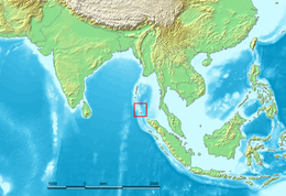 Location of the Nicobar Islands in the Indian Ocean. | |
 | |
| Geography | |
|---|---|
| Location | Bay of Bengal |
| Coordinates | 7°05′N 93°48′E |
| Archipelago | Andaman and Nicobar Islands |
| Total islands | 22 |
| Major islands | Car Nicobar, Great Nicobar, Little Nicobar |
| Area | 1,841 km2 (711 sq mi) |
| Highest elevation | 642 m (2106 ft) |
| Highest point | Mount Thullier |
| Administration | |
| Union territory | Andaman and Nicobar Islands |
| Capital city | Port Blair (on South Andaman Island) |
| Largest settlement | Malacca, Car Nicobar (pop. 1,637) |
| Demographics | |
| Population | 36,842 (2011) |
| Pop. density | 20/km2 (50/sq mi) |
| Ethnic groups | Nicobarese Shompen Mainland Indians |
| Additional information | |
| Time zone |
|
| • Summer (DST) |
|
| Official website | https://andaman.nic.in/ |
UNESCO has declared the Great Nicobar Island as one of the World Network of Biosphere Reserves.[1]
Geography
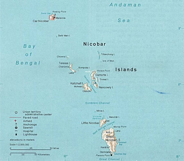
The Nicobar Islands cover a land area of 1,841 square kilometres (711 sq mi)[2] and had a population of 36,844 during the 2011 Census. They comprise three distinct groups:
- Chowra, Chaura or Sanenyo
- Teressa or Luroo
- Bompuka or Poahat
- Katchal
- Camorta
- Nancowry or Nancowrie
- Trinket
- Laouk or "Isle of Man"
- Tillangchong
Southern Group (Sambelong):
- Great Nicobar (922 km2 or 356 sq mi, largest island of the Nicobars)
- Little Nicobar
- Kondul Island
- Pulo Milo or Pillomilo (Milo Island)
- Meroe, Trak, Treis, Menchal, Kabra, Pigeon and Megapod
Indira Point (6.756378°N 93.827765°E) is the southernmost point of Great Nicobar Island and also of India itself, lying about 150 kilometres (93 mi) north of Sumatra, Indonesia.
Geology
The Nicobar Islands are part of a great island arc created by the collision of the Indo-Australian Plate with Eurasia. The collision lifted the Himalayas and most of the Indonesian islands, and created a long arc of highlands and islands, which includes the Arakan Yoma range of Burma, the Andaman and Nicobar islands, and the islands off the west coast of Sumatra, including the Banyak Islands and Mentawai Islands.[3]
Climate
The climate is warm and tropical, with temperatures ranging from 22 to 30 °C (72 to 86 °F). Rainfall is heavy due to annual monsoons and measures around 3,000 to 3,800 mm (120 to 150 in) each year.[3]
Ecology

The Nicobar Islands are recognised as a distinct terrestrial ecoregion, the Nicobar Islands rain forests, with many endemic species.[3]
The vegetation of the Nicobars is typically divided into the coastal mangrove forests and the interior evergreen and deciduous tropical and subtropical moist broadleaf forests. Additionally, several islands contain extensive inland grasslands, though these are thought to have resulted from human intervention.[3]
As a result of lower sea levels during the ice ages, the Andaman Islands were linked to the Southeast Asian mainland, but it is not believed that the Nicobar Islands ever had a land bridge to the continent. Lower sea levels did link the islands to one another: Great Nicobar and Little Nicobar were linked to each other, and Nancowry, Chaura, Katchall, Trinka, Camorta, and the nearby smaller islands were linked to one another as well.
Protected areas
Protected areas include Campbell Bay National Park and Galathea National Park on Great Nicobar.
A World Biosphere Reserve was declared on Grand Nicobar by UNESCO on May 31, 2013.[4] Great Nicobar Biosphere Reserve has a total area of 103,870 hectares (256,700 acres). The core area of 53,623 hectares (132,510 acres) comprises Cambell Bay and Galathea National parks. A buffer area of 34,877 hectares (86,180 acres) includes lands adjacent to and between the two parks. There is also a transitional area of 10,070 hectares (24,900 acres), including 5,300 marine hectares (13,000 acres).[5][3]
Population
| Year | Pop. | ±% p.a. |
|---|---|---|
| 1901 | 6,511 | — |
| 1911 | 8,818 | +3.08% |
| 1921 | 9,272 | +0.50% |
| 1931 | 10,240 | +1.00% |
| 1941 | 12,452 | +1.98% |
| 1951 | 12,009 | −0.36% |
| 1961 | 14,563 | +1.95% |
| 1971 | 21,665 | +4.05% |
| 1981 | 30,454 | +3.46% |
| 1991 | 39,208 | +2.56% |
| 2001 | 42,068 | +0.71% |
| 2011 | 36,842 | −1.32% |
| source:[6] | ||
The islands had a population of 36,842 at the 2011.[7] The indigenous ethnic groups are the Nicobarese and the Shompen. Local languages include Shompen and the languages of the Nicobarese group.
History
Prehistory
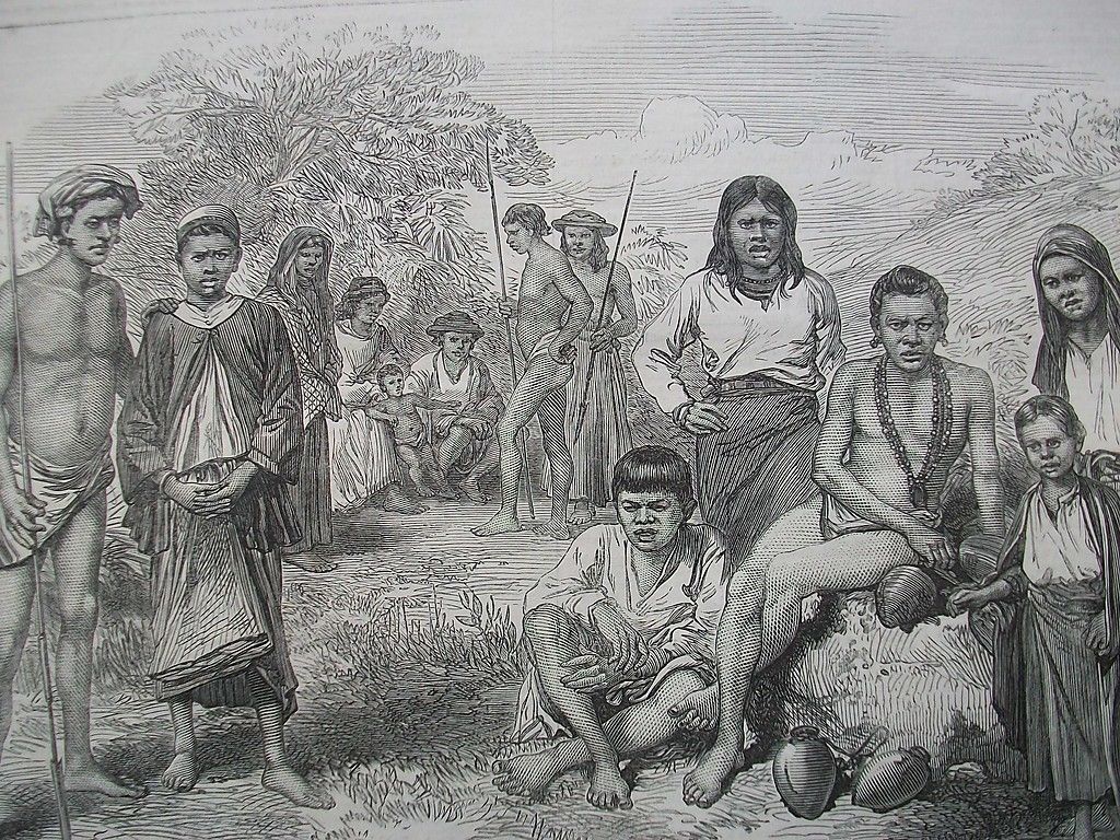
The Nicobar Islands are believed to have been inhabited for thousands of years. Six indigenous Nicobarese languages are spoken on the islands, which are part of the Austroasiatic language family, which includes Mon, Khmer and Vietnamese languages of Southeast Asia, and the Munda languages of India. An indigenous tribe living at the southern tip of Great Nicobar, called the Shompen, may be of Mesolithic South-east Asian origin.[8]
Origin of the name
The earliest extant references to the name "Nicobar" is in the Sri Lankan Pali Buddhist chronicles, the Dipavamsa (c. 3rd or 4th century CE) and the Mahavamsa (c. 4th or 5th century), which state that the children of the followers of the legendary founder of the Sri Lankan Kingdom, Vijaya, landed on Naggadipa (the island of the children, from the Pali nagga meaning 'naked').[9] The modern name is likely derived from the Chola dynasty name for the islands, Nakkavaram (may be referring open/naked land or naked mans land in Tamil) which is inscribed on the Thanjavur (Tanjore) inscription of 1050 CE.[10][11][12] Marco Polo (12th-13th century) also referred to this island as 'Necuverann'.
In the 15th century, Great Nicobar Island was recorded as "Cui Lan island" (翠蘭嶼) during the voyages of Zheng He in the Mao Kun map of the Wu Bei Zhi.[13]
Colonial period
The history of organised European colonisation on the islands began with the Danish East India Company in 1754/56. During this time they were administrated from Tranquebar (in continental Danish India) administrated under the name of Frederiksøerne; missionaries from the Moravian Church Brethren's settlement in Tranquebar attempted a settlement on Nancowry and died in great numbers from disease; the islands were repeatedly abandoned due to outbreaks of malaria: 1784–1807/09, 1830–1834 and finally from 1848 gradually for good. Between 1778 and 1783, William Bolts attempted to establish an Austrian colony on the islands on the mistaken assumption that Denmark–Norway had abandoned its claims to the islands.[14]
Italy made an attempt at buying the Nicobar Islands from Denmark between 1864 and 1865. The Italian Minister of Agriculture and Commerce Luigi Torelli started a negotiation that looked promising, but failed due to the unexpected end of his office and the second La Marmora Cabinet. The negotiations were interrupted and never brought up again.[15]
Denmark's presence in the islands ended formally on 16 October 1868 when it sold the rights to the Nicobar Islands to the UK,[14] which, in 1869, made them part of British India.
Second World War
During the Second World War, the islands were invaded and occupied by Japan between 1942 and 1945. In May 1945, HMS Ceylon shelled Japanese positions on the islands. The British regained possession of the islands after the Surrender of Japan, announced on 15 August and formally signed on 2 September 1945.
Indian state
Together with the Andaman Islands, it became part of India in 1950 and was declared as a union territory of the nation in 1956.[16]
26 December 2004 tsunami
On 26 December 2004, the coast of the Nicobar Islands was devastated by a 10-to-15-metre-high (33 to 49 ft) tsunami following the 2004 Indian Ocean earthquake. At least 6,000 people were killed on the Andaman and Nicobar Islands with reports putting the death toll on Katchal Island alone at 4,600.
Several islands were heavily damaged with initial reports of islands broken in two or three pieces and coral reefs moved above water. Teressa Island was said to have been split into two pieces and Trinkat Island into three pieces. Some estimates said that the islands were moved as much as 30 metres (100 ft) by the earthquake and tilted.
Indira Point subsided 4.25 metres (13.9 ft) and the lighthouse there was damaged.
Transportation
- Airport: Car Nicobar CBD/VECX has an airstrip on Car Nicobar Air Force Base of 2,717 by 43 metres (8,914 by 141 ft) on the South East coast near Malacca but does not offer commercial service. Great Nicobar has a small airstrip of approximately 1,000 metres (3,300 ft) at Campbell Bay/Tenlaa on its East coast.
- Seaport: At least one small shipping dock is located in Campbell Bay on the East coast of Great Nicobar. Car Nicobar has a small dock at its Northern tip near Keating Point and Mus.
See also
- Nicobarese people
- Nicobarese languages
- Shompen people
- Austrian colonization of the Nicobar Islands
- 1881 Nicobar Islands earthquake
- Great Nicobar Biosphere Reserve
- Great Nicobar
- Malaysia Airlines Flight MH370
- Indian Ocean
References
- , The International Coordinating Council of UNESCO’s Man and the Biosphere Programme (MAB), added the following new sites to the World Network of Biosphere Reserves (WNBR) http://www.unesco.org/new/en/media-services/multimedia/photos/mab-2013/india/.
- Nicobar Islands. Encyclopedia Britannica.
- "Nicobar Islands rain forests". Terrestrial Ecoregions. World Wildlife Fund.
- "Nicobar Islands declared as world biosphere reserve". The Times of India. 31 May 2013. Retrieved 31 May 2013.
- "Great Nicobar". Man and Biosphere Programme, United Nations Educational, Scientific, and Cultural Organization (UNESCO). Accessed 1 August 2021. http://www.unesco.org/new/en/natural-sciences/environment/ecological-sciences/biosphere-reserves/asia-and-the-pacific/india/great-nicobar
- Decadal Variation In Population Since 1901
- "Demography | District Nicobar, Government of Andaman and Nicobar | India". Retrieved 7 November 2022.
- Rajni Trivedi; et al. (March 2006). "Molecular insights into the origins of the Shompen, a declining population of the Nicobar archipelago". Journal of Human Genetics. 51 (3): 217–226. doi:10.1007/s10038-005-0349-2. PMID 16453062.
- Wilhelm Geiger (Tr) (1912). The Mahavamsa or The Great Chronicle of Ceylon (PDF). Pali Text Society. ISBN 978-81-206-0218-2. Archived from the original (PDF) on 12 May 2012. Retrieved 8 July 2013.
P54 "The island where the children landed was called Naggadipa..." N: "l That is,'Island of children', from nagga 'naked'..."
"Archived copy" (PDF). Archived from the original (PDF) on 12 May 2012. Retrieved 8 July 2013.{{cite web}}: CS1 maint: archived copy as title (link) - C Rasanayagam (1926). Ancient Jaffna. Asian Educational Society (reprint). ISBN 978-81-206-0210-6.
P53 "Naggadipa, where the children are alleged to have landed, is certainly Nicobars, the Nakkavaram of the Tamils, ...
- John Keay (2001). India: A History. Grove Press. ISBN 978-0-8021-3797-5.
... and 'Nakkavaram' certainly represents the Nicobar islands ...
- The New Encyclopædia Britannica. Encyclopædia Britannica. 1998. ISBN 978-0-85229-633-2. Retrieved 16 November 2008.
... The name Nicobar probably is derived from Nakkavaram ("Land of the Naked") ...
- "Wu Bei Zhi Map 17". Library of Congress.
- Ramerini, Marco. "Chronoly of Danish Colonial Settlements". ColonialVoyage.com. Archived from the original on 4 April 2005. Retrieved 3 January 2010.
- Ministero della Guerra, Ufficio Storico, Storia Militare della Colonia Eritrea, Vol. I, Roma 1935, pp. 15-16
- Planning Commission of India (2008). Andaman and Nicobar Islands Development Report. State Development Report series (illustrated ed.). Academic Foundation. ISBN 978-81-7188-652-4. Retrieved 12 March 2011.
External links
- "Nicobarese and Shompen". The Andaman Association. Archived from the original on 9 July 2011. Retrieved 1 July 2011. Archived 9 July 2011 at the Wayback Machine
- WorldStatesmen- India
Danish overseas empire | |||||||||||||||||||||
|---|---|---|---|---|---|---|---|---|---|---|---|---|---|---|---|---|---|---|---|---|---|
| |||||||||||||||||||||
| |||||||||||||||||||||
| |||||||||||||||||||||
| |||||||||||||||||||||
| |||||||||||||||||||||
| |||||||||||||||||||||
| |||||||||||||||||||||

Authority control | |
|---|---|
| General | |
| National libraries | |
| Other | |
На других языках
[de] Nikobaren
Die Nikobaren (auch Nicobaren) sind eine zum indischen Unionsterritorium Andamanen und Nikobaren gehörende Inselgruppe im Golf von Bengalen.- [en] Nicobar Islands
[es] Islas Nicobar
Las islas Nicobar (en hindi: निकोबार द्वीप समूह; en tamil: நக்காவரம்) forman un archipiélago situado en la parte oriental del océano Índico, perteneciente administrativamente al territorio indio de las Islas Andamán y Nicobar. Son 22 islas, siendo la mayor Gran Nicobar. El área total del archipiélago es de 1 841 km². El punto más alto es monte Thullier de 642 m. La población de las islas era de 42.026 personas en 2001, aproximadamente el 65% eran indígenas de Nicobar y el resto inmigrantes de la India y Sri Lanka.[fr] Îles Nicobar
Les îles Nicobar sont un archipel de la mer d'Andaman, dans le nord-est de l'océan Indien.[it] Nicobare
Le Isole Nicobàre sono un arcipelago dell'oceano indiano orientale, situate a sud-est del subcontinente indiano, 150 km a sud delle isole Andamane con le quali formano il Territorio indiano delle Andamane e Nicobare.[ru] Никобарские острова
Никоба́рские острова (англ. Nicobar Islands, хинди निकोबार द्वीप समूह, там. நக்காவரம்) — группа островов в Бенгальском заливе, относящаяся к индийской союзной территории Андаманские и Никобарские острова. Никобарские острова расположены южнее Андаманских островов.Другой контент может иметь иную лицензию. Перед использованием материалов сайта WikiSort.org внимательно изучите правила лицензирования конкретных элементов наполнения сайта.
WikiSort.org - проект по пересортировке и дополнению контента Википедии