geo.wikisort.org - Island
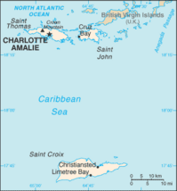
Saint Thomas (Danish: Sankt Thomas) is one of the Virgin Islands in the Caribbean Sea which, together with Saint John, Water Island, Hassel Island, and Saint Croix, form a county-equivalent and constituent district of the United States Virgin Islands (USVI), an unincorporated territory of the United States. The territorial capital and port of Charlotte Amalie is located on the island. In the 2010 census, the population of Saint Thomas was 51,634,[2] about 48.5% of the US Virgin Islands total. As of the 2020 census, the population of Saint Thomas is 42,461.[3] The district has a land area of 32 square miles (83 km2).[4]
 Charlotte Amalie, St. Thomas | |
 St. Thomas  St. Thomas  St. Thomas | |
| Geography | |
|---|---|
| Location | Caribbean Sea |
| Coordinates | 18°20′N 64°55′W |
| Archipelago | Virgin Islands, Leeward Islands |
| Area | 32 sq mi (83 km2) |
| Highest elevation | 1,555 ft (474 m) |
| Highest point | Crown Mountain[1] |
| Administration | |
| Insular area | |
| Largest settlement | Charlotte Amalie (pop. 14,477) |
| Demographics | |
| Population | 42,261 (2020) |
| Pop. density | 638.17/km2 (1652.85/sq mi) |
History
Pre-colonial history
The island was originally settled around 1500 BC by the Ciboney people. Ciboney sites have been uncovered in Krum Bay.[5][6] The island was later inhabited by the Arawaks and then the Caribs. Arawak sites have been uncovered in Magen's Bay and Botany Bay, and Carib sites have been uncovered in Magen's Bay and Salt River.[5]
Christopher Columbus sighted the island in 1493 on his second voyage to the New World.[7]
Danish and German colonial period
The Dutch West India Company established a post on Saint Thomas in 1657.[8] The first congregation was the St. Thomas Reformed Church, which was established in 1660 and was associated with the Dutch Reformed Church.[9]
Denmark-Norway's first attempt to settle the island in 1665 failed. However, the Danes did resettle St. Thomas in 1671, under the sponsorship of the Glueckstadt Co., later the Danish West India Company.[10] The first slave ships arrived in 1673, and St. Thomas became a slave market. In 1685, the Danish leased part of the island to the Brandenburger Company,[8] which was resold to the Danish in 1754,[10] and was granted free port status in 1764.[11]
The land was divided into plantations and sugarcane production became the primary economic activity. As a result, the economies of Saint Thomas and the neighboring islands of Saint John and Saint Croix became highly dependent on slave labor and the slave trade. In 1685, the Brandenburgisch-Africanische Compagnie took control of the slave trade on Saint Thomas, and for some time the largest slave auctions in the world were held there.

Saint Thomas's fine natural harbor became known as "Taphus" for the drinking establishments located nearby. ("Tap Hus" translates as "rum shop" or "tap house" referring to the drinking establishments.[12]) In 1691, the primary settlement there was renamed Charlotte Amalie in honor of the wife of Denmark's King Christian V. It was later declared a free port by Frederick V. In December 1732, the first two of many Moravian Brethren missionaries came from Herrnhut Saxony in present-day Germany to minister to them. Distrusted at first by the white masters, they lived among the slaves and soon won their confidence.[13]

The first British invasion and occupation of the island occurred in 1801. The islands were returned to Denmark in 1802, under the terms of the Treaty of Amiens. Fire destroyed hundreds of homes in Charlotte Amalie in 1804. The second British occupation of the island occurred from 1807 to 1815, after the Invasion of the Danish West Indies (1807), during which they built Fort Cowell on Hassel Island.[11]
While the sugar trade had brought prosperity to the island's free citizens, by the early 19th century Saint Thomas was in decline. The continued export of sugar was threatened by hurricanes, drought, and American competition. Following the Danish Revolution of 1848, slavery was abolished and the resulting rise in labor costs further weakened the position of Saint Thomas's sugar producers.[citation needed]
Given its harbors and fortifications, Saint Thomas still retained a strategic importance, and thus, in the 1860s, during the American Civil War and its aftermath, the United States government considered buying the island and its neighbors from Denmark for $7.5 million. However, the proponents of the purchase failed to gain legislative support for the bid.[citation needed]
Freedom of the press
In 1915, David Hamilton Jackson traveled to Denmark and convinced the King of Denmark to allow freedom of the press in Saint Thomas, Saint John, and Saint Croix.[14] He began the first newspaper in the islands, known as The Herald. Jackson was the editor of The Herald, which had its office at 1B Kongens Gade in Christiansted.[15] The newspaper's focus was civic and labor rights for local workers,[16] and it published criticisms of the labor situation in the islands.[15] After beginning The Herald, Jackson organized labor unions among the islanders for better working conditions. He was also instrumental in persuading the Danish to allow the US to purchase the islands of Saint Thomas, Saint John, and Saint Croix. The islands now have an annual celebration in November to honor the legacy of David Hamilton Jackson.[17]
United States acquisition

In 1917, Saint Thomas was purchased (along with Saint Croix and Saint John) by the United States for $25 million in gold ($529 million today),[18] as part of a defensive strategy to maintain control over the Caribbean and the Panama Canal during the First World War. The transfer occurred on March 31, 1917, behind Fort Christian before the barracks that now house the Legislature of the U.S Virgin Islands. The baccalaureate service for the transfer was held at the St. Thomas Reformed Church as it was identified as the American church in the Danish West Indies.
At the time of the US purchase in 1917, the colony did not include Water Island, which had been sold by Denmark to the East Asiatic Company, a private shipping company, in 1905. The company eventually sold the island to the United States in 1944, during the German occupation of Denmark. The federal government then used the island for military purposes until 1950, before finally transferring it to the territorial government in 1996.[19]
The United States granted citizenship to the residents in 1927. The U.S. Department of the Interior took over administrative duties in 1931. American forces were based on the island during the Second World War. In 1954, passage of the U.S. Virgin Islands Organic Act officially granted territorial status to the three islands, and allowed for the formation of a local senate with politics dominated by the American Republican and Democratic parties. Full home rule was achieved in 1970.
The post-war era also saw the rise of tourism on the island. With relatively cheap air travel and the American embargo on Cuba, the numbers of visitors greatly increased. Despite natural disasters such as Hurricane Hugo (1989), Hurricanes Luis and Marilyn (1995), and Hurricanes Irma and Maria (2017) the island's infrastructure continues to improve as the flow of visitors continues. Hotels have been built from the West End to the East End.
Geography
The island has a number of natural bays and harbors including Magens Bay, Great Bay, Jersey Bay, Long Bay, Fortuna Bay, and Hendrik Bay. Passenger ships dock and anchor in Long Bay, near Charlotte Amalie. Ships dock at Havensight Pier. Red Hook is an unofficial "town" located on the East End subdistrict.
Climate
Saint Thomas has a tropical savanna climate (Aw according to the Köppen climate classification) with a drier season and a wetter season. The temperature is warm year-round, with January and February, the coolest months, having average highs of 29.5 °C (85.1 °F) and average lows of 22.4 °C (72.3 °F). August has the highest average high of 32.3 °C (90.1 °F), with July, August and September all having the highest average low at 25.6 °C (78.1 °F). The highest temperature ever recorded was 37.2 °C (99.0 °F) on 4 August 1994 and 23 June 1996, which is the highest temperature to have ever been recorded in the United States Virgin Islands.[20] The lowest recorded temperature was 11 °C (52 °F) in November.[year needed]
Saint Thomas receives 989 millimetres (38.9 in) of precipitation annually over 163.6 precipitation days. Autumn is the wettest time of year because of tropical cyclones. November is the wettest month, receiving 152 millimetres (6.0 in) of rain on average over 17.8 precipitation days, the most of any month. March is the driest month, receiving 27 millimetres (1.1 in) of rainfall over 8.1 precipitation days, the least of any month.
| Climate data for Saint Thomas, United States Virgin Islands | |||||||||||||
|---|---|---|---|---|---|---|---|---|---|---|---|---|---|
| Month | Jan | Feb | Mar | Apr | May | Jun | Jul | Aug | Sep | Oct | Nov | Dec | Year |
| Record high °F (°C) | 93 (34) |
93 (34) |
94 (34) |
96 (36) |
97 (36) |
99 (37) |
98 (37) |
99 (37) |
98 (37) |
97 (36) |
95 (35) |
92 (33) |
99 (37) |
| Average high °F (°C) | 85.1 (29.5) |
85.1 (29.5) |
85.7 (29.8) |
86.7 (30.4) |
87.6 (30.9) |
89.1 (31.7) |
89.9 (32.2) |
90.2 (32.3) |
90.0 (32.2) |
88.7 (31.5) |
87.1 (30.6) |
85.6 (29.8) |
87.6 (30.9) |
| Average low °F (°C) | 72.4 (22.4) |
72.3 (22.4) |
72.9 (22.7) |
74.1 (23.4) |
76.2 (24.6) |
77.7 (25.4) |
78.0 (25.6) |
78.1 (25.6) |
78.0 (25.6) |
76.9 (24.9) |
75.2 (24.0) |
73.7 (23.2) |
75.5 (24.2) |
| Record low °F (°C) | 63 (17) |
62 (17) |
56 (13) |
58 (14) |
66 (19) |
67 (19) |
57 (14) |
59 (15) |
64 (18) |
66 (19) |
52 (11) |
62 (17) |
52 (11) |
| Average precipitation inches (mm) | 2.16 (55) |
1.47 (37) |
1.05 (27) |
2.62 (67) |
3.05 (77) |
2.62 (67) |
2.82 (72) |
3.51 (89) |
4.82 (122) |
5.94 (151) |
6.00 (152) |
2.88 (73) |
38.95 (989) |
| Average precipitation days (≥ 0.01 in) | 14.3 | 11.8 | 8.1 | 10.7 | 11.9 | 11.1 | 14.8 | 14.2 | 14.6 | 17.7 | 17.8 | 16.7 | 163.6 |
| Source 1: NOAA (normals 1981−2010)[21] | |||||||||||||
| Source 2: Weather Channel[22] | |||||||||||||
Demographics
Saint Thomas is divided into the following subdistricts (with population as per the 2020 U.S. Census):
- Charlotte Amalie (pop. 14,477) Charlotte Amalie town (pop. 8,194)
- East End (pop. 7,502)
- Northside (pop. 8,889)
- Southside (pop. 4,112)
- Tutu (pop. 5,129)
- Water Island (pop. 164)
- West End (pop. 1,988)

Historical ethnic communities
From 1796 a small Jewish community developed in Charlotte Amalie. It established the Beracha Veshalom Vegmiluth Hasadim, the second oldest synagogue in the United States.[23]
During the late nineteenth and early twentieth centuries a group of French Catholic immigrants known as the Chacas came to St. Thomas from the St. Barthélemy islands to the east, forming one community of fishermen and one of farmers.[24][25]
Transportation

The island is serviced by the Cyril E. King International Airport.
Passenger and limited car-ferry services to neighboring islands such as Water Island, Saint John, Saint Croix, and the British Virgin Islands run regularly out of the Red Hook Terminal, Charlotte Amalie, and Crown Bay Marina.
The United States Virgin Islands is the only place under United States jurisdiction where the rule of the road is to drive on the left. This was inherited from what was the then-current Danish practice at the time of the American acquisition in 1917. However, because the islands are a U.S. territory, most cars are imported from the mainland United States and therefore the steering column is located on the left side of the vehicle.
The island has many regular taxis from compact size to large vans, as well as open-air, covered trucks called "safaris" with bench seats. The latter usually operate only between high-traffic points, e.g., cruise-ship terminals at Havensight and Crown Bay and downtown Charlotte Amalie.
Education
St. Thomas-St. John School District operates public schools on Saint Thomas.
Private schools:
- Antilles School
- Virgin Islands Montessori School & Peter Gruber International Academy
Parochial schools:
- All Saints Cathedral School
- Sts. Peter & Paul Catholic School
- Calvary Christian Academy
- Church of God Academy
- Memorial Moravian School
- Seventh Day Adventist School
- Weslyan Academy Bible School
Colleges and universities:
- University of the Virgin Islands
Notable people
- Alton Augustus Adams − first African-American band master for the United States Navy
- Pamela Balash-Webber (1953-2020), diving instructor
- Jabari Blash − baseball player, outfielder for the Tohoku Rakuten Golden Eagles
- Edward Wilmot Blyden − ambassador, an Igbo in Diaspora; credited in some history books as having laid the foundation of West African nationalism and Pan-Africanism
- Callix Crabbe − Major League Baseball player
- Midre Cummings − Major League Baseball player
- Vanessa Daou − singer-songwriter, dancer, writer, poet
- Charles Joseph Sainte-Claire Deville − French geologist
- Henri Étienne Sainte-Claire Deville − French chemist
- Jeff Faulkner − National Football League player
- Kelsey Grammer − actor, director, and producer born in Saint Thomas
- Emile Griffith − former boxer who won world championships in both the Welterweight and Middleweight divisions
- Jean Hamlin − 17th-century French buccaneer
- Elrod Hendricks − Major League Baseball player
- Abdul Hodge − National Football League player
- Daryl Homer − Olympic fencer
- Roy Innis − civil rights leader
- Julian Jackson − boxer born in Saint Thomas
- Hannah Jeter − Sports Illustrated swimsuit cover model and wife of Derek Jeter of the New York Yankees
- J. Raymond Jones − political activist
- Christine Jowers − choreographer, producer, and dance critic
- Al McBean − Major League Baseball player
- Gabriel Milan − Governor, 1684−1686
- Akeel Morris (born 1992) − baseball player in the San Francisco Giants organization
- Ralph Moses Paiewonsky − governor
- John Patrick − screenwriter and Tony Award & Pulitzer Prize-winning playwright
- Barbara A. Petersen − administrator for Saint Thomas and Water Island
- Calvin Pickering − Major League Baseball player
- Camille Pissarro − key member of the French Impressionist group of painters
- Rashawn Ross − trumpeter who tours with Dave Matthews Band
- Roy Lester Schneider − governor and physician
- Morris Simmonds − German physician, pathologist, described a syndrome of pituitary failure with emaciation (Simmonds syndrome)
- Karrine Steffans − former hip-hop music video performer, actress, author of Confessions of A Video Vixen
- Edward Teach − pirate and privateer; may have been given a letter of marque from St. Thomas after being pardoned for pirating
- Terence Todman − ambassador
- Jean Toussaint − jazz tenor and soprano saxophonist
- Denmark Vesey − leader of planned slave uprising in Charleston, South Carolina
- Peter von Scholten − governor general
- Tiphanie Yanique – writer
- David Levy Yulee − politician and the first member of the United States Senate to have been, at one time, a practicing Jew
In popular culture
Music
"St. Thomas" is among the most recognisable instrumentals in the repertoire of American jazz tenor saxophonist Sonny Rollins based on a traditional calypso sung to him by his mother, Valborg Solomon Rollins, who was born on Saint Thomas.[26]
Points of interest
- Blackbeard's Castle
- Buck Island National Wildlife Refuge
- Cathedral Church of All Saints
- Coral World Ocean Park
- Fort Christian
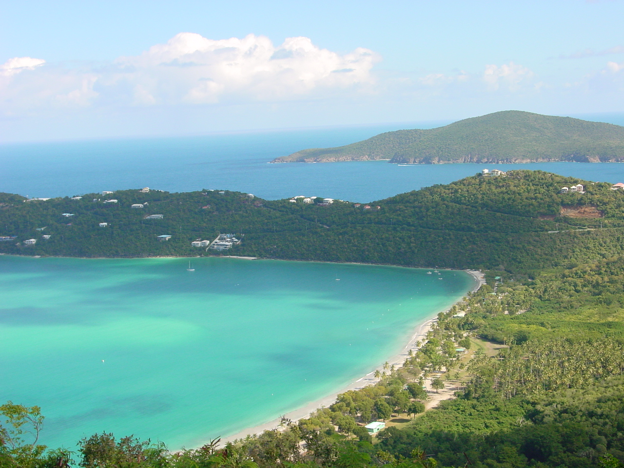
- Magens Bay Arboretum
- Magens Bay
- Red Hook
- Saints Peter and Paul Cathedral
- St. Thomas Synagogue
Gallery
 Blackbeard's Castle in Charlotte Amalie
 Magens Bay as seen from Drake's Seat, St. Thomas
 View from Bluebeard's Castle, St. Thomas
 Magens Bay


References
- "Where is the U.S. Virgin Islands: Geography". vinow.com. Retrieved April 8, 2017.
- Kossler, Bill (August 24, 2011). "USVI Population Down Since 2000". stthomassource.com. V.I. Source Publications. Retrieved January 11, 2017.
- "USVI Population Shrank 18 Percent Since 2010". October 29, 2021. Retrieved October 31, 2021.
- This is the figure given on page 1 of the United States Geological Survey's Open-File Report 72-201. It is also the figure given in the article at the on-line edition of the Encyclopedia Britannica. The Virgin Islands (United States) page at the United Nations Environmental Programme's Island Directory gives a substantially lower figure, reporting the area as 69.7 square kilometers, equivalent to 26.9 square miles. And although the U.S. Census Bureau does not report the areas of geographic entities, it does report their population densities (equal to the total population divided by the area). In the 2010 census, the population was reported as 51,634 (Table P1, "Total Population") and the population density was reported as 1,649.1 per square mile (Table P40, "Population Density"). Together, these figures imply an area of 31.3 square miles.
- Dookhan, Isaac (1994). A History of the Virgin Islands of the United States. Canoe Press. ISBN 978-976-8125-05-7.
- Bullen, Ripley P.; Sleight, Frederick W. (1963). The Krum Bay Site: A Preceramic Site on St. Thomas, United States Virgin Islands. Bryant Foundation.
- "History: NRCS Caribbean Area". Natural Resources Conservation Services. United States Department of Agriculture. July 9, 2022. Archived from the original on June 24, 2022. Retrieved July 8, 2022.
- "St. Thomas: island, United States Virgin Islands – Britannica". Encyclopædia Britannica. Retrieved April 20, 2021.
- "History Timeline". St. Thomas Reformed Church (strchurch.org). Archived from the original on July 10, 2022. Retrieved July 10, 2022.
- "St. Thomas, Virgin Islands: Facts & History". VInow. Retrieved April 20, 2021.
- U.S. Virgin Islands: a guide to national parklands in the United States Virgin Islands. Washington, D.C.: Division of Publications, National Park Service, U.S. Dept. of the Interior. 1999. pp. 24–25, 37–39. ISBN 0912627689.
- "Charlotte Amalie St. Thomas U.S. Virgin Islands". guidetocaribbeanvacations.com.
- Hamilton, J. Taylor and Hamilton, Kenneth G., History of the Moravian Church, Bethlehem, PA, 1969.
- "David Hamilton Jackson - Famous Virgin Islander". here.vi.
- "The Herald newspaper". The Danish West-Indies. Retrieved July 10, 2022.
- Blaagaard, Bolette B. (July 27, 2018). Citizen Journalism as Conceptual Practice: Postcolonial Archives and Embodied Political Acts of New Media. Rowman & Littlefield. ISBN 978-1-78660-109-4.
- Liberty Day festivities to include parade, re-enactment about D. Hamilton Jackson, The Virgin Islands Daily News.
- Department Of State. The Office of Electronic Information, Bureau of Public Affairs (July 21, 2008). "Purchase of the United States Virgin Islands, 1917". 2001-2009.state.gov. Retrieved July 10, 2022.
- "Water Island History - the Military History of Water Island".
- "All Time Extremes for PR and VI". National Weather Service. Archived from the original on January 19, 2017. Retrieved January 19, 2017.
- "NOWData - NOAA Online Weather Data". National Oceanic and Atmospheric Administration. Retrieved January 19, 2013.
- "Average Conditions Saint Thomas, VI". weather.com. Retrieved May 16, 2010.
- Arts & Culture US Virgin Island Tourism
- Williams, Eric (January 1, 1945). "Race Relations in Puerto Rico and the Virgin Islands". Foreign Affairs. Vol. 23, no. 2. ISSN 0015-7120.
- Shaw, Earl B. (February 1934). "The Chachas of Saint Thomas". The Scientific Monthly. American Association for the Advancement of Science. 38 (2): 136–145. ISSN 0096-3771. JSTOR 15662.
- Gioia, Ted (September 27, 2012), The jazz standards: a guide to the repertoire, Oxford University Press (published 2012), p. 357, ISBN 978-0-19-993739-4
Authority control | |
|---|---|
| General | |
| National libraries | |
| Other |
|
На других языках
[de] Saint Thomas
Saint Thomas (dänisch Sankt Thomas) ist eine Insel der Amerikanischen Jungferninseln in der Karibik, die zu den nicht inkorporierten Außengebieten der Vereinigten Staaten zählt. Auf der Insel befindet sich auch die Hauptstadt des Gebietes, Charlotte Amalie. Von 1672 bis 1917 war Saint Thomas die wichtigste der drei Inselkolonien im ehemaligen Dänisch-Westindien, zu denen noch Saint Croix und Saint John gehören.- [en] Saint Thomas, U.S. Virgin Islands
[es] Saint Thomas (Islas Vírgenes)
Saint Thomas (en español, Santo Tomás) es una isla ubicada en el mar Caribe. Es la isla principal de las Islas Vírgenes territorio de los Estados Unidos y en ella se ubica la principal ciudad y puerto de la isla Carlota Amalia, que es también la capital del archipiélago. En el censo del año 2000 la población de Saint Thomas era de 51 181 habitantes, que constituían el 47 % aproximadamente de la población de las Islas Vírgenes de los Estados Unidos. La isla tiene una extensión de 80,9 km².[fr] Saint-Thomas (îles Vierges des États-Unis)
Saint-Thomas est une île qui constitue avec celles de Saint John et Sainte-Croix les îles Vierges des États-Unis, c'est également l'un des trois districts de ce territoire. L'île a une superficie de 81 km2 et comptait 51 000 habitants en 2000. La ville principale est Charlotte-Amélie (en anglais Charlotte Amalie), capitale de l'archipel. Saint-Thomas comptait autrefois parmi les repaires de corsaires, pirates et flibustiers et c'est une zone franche douanière et fiscale (comme d'autres îles des Caraïbes : Saint-Martin, Saba, Saint-Eustache ou Anguilla), ce qui en fait l'un des paradis fiscaux des États-Unis [1].[it] Saint Thomas (Isole Vergini americane)
Saint Thomas è un'isola caraibica delle piccole Antille appartenente all'arcipelago delle Isole Vergini americane, situata a est di Porto Rico e a ovest di Saint John. L'isola è nota anche perché ci nacque il famoso pugile Emile Griffith il 3 febbraio 1938.[ru] Сент-Томас
Сент-То́мас (Св. Фомы, англ. Saint Thomas, дат. Sankt Thomas) — один из Американских Виргинских островов, неинкорпорированной территории США, расположенной в Карибском море. На острове находится столица территории — порт Шарлотта-Амалия. Население (по переписи 2010 года) — &&&&&&&&&&051634.&&&&&051 634 чел. — 48,5 % всего населения Американских Виргинских островов. Площадь территории — 80,91 км². Наиболее освоенный из американской части островов.Другой контент может иметь иную лицензию. Перед использованием материалов сайта WikiSort.org внимательно изучите правила лицензирования конкретных элементов наполнения сайта.
WikiSort.org - проект по пересортировке и дополнению контента Википедии