geo.wikisort.org - Island
Great Nicobar is the southernmost and largest of the Nicobar Islands of India, north of Sumatra.
Native name: Tokieong Long | |
|---|---|
 Great Nicobar Location of Great Nicobar Island in the Andaman and Nicobar Islands  Great Nicobar Great Nicobar (Bay of Bengal) | |
| Geography | |
| Location | Bay of Bengal |
| Coordinates | 7.03°N 93.8°E |
| Archipelago | Nicobar Islands |
| Adjacent to | Indian Ocean |
| Total islands | 1 |
| Major islands |
|
| Area | 921 km2 (356 sq mi)[1] |
| Coastline | 202 km (125.5 mi) |
| Highest elevation | 642 m (2106 ft) |
| Highest point | Mount Thullier |
| Administration | |
| District | Nicobar |
| Island group | Nicobar Islands |
| Subdivisions of India | Great Nicobar Subdivision |
| Taluk | Split between Little Nicobar and Campbell Bay Taluk |
| Largest settlement | Campbell Bay (pop. 5,740) |
| Demographics | |
| Population | 8,067 (2014) |
| Pop. density | 8.8/km2 (22.8/sq mi) |
| Ethnic groups | Hindustani, Punjabi, Nicobarese Shompen, Malay |
| Additional information | |
| Time zone |
|
| PIN | 744301 |
| Area code(s) | 03192 |
| ISO code | IN-AN-00[2] |
| Official website | andaman |
| Literacy | 84.4% |
| Avg. summer temperature | 32.0 °C (89.6 °F) |
| Avg. winter temperature | 28.0 °C (82.4 °F) |
| Sex ratio | ♂/♀ |
| Census Code | 35.638.0002 |
| Official Languages | Punjabi, English, Tamil Southern Nicobarese (regional) |
History
In the 15th century, Great Nicobar Island was recorded as "Cui Lan island" (翠蘭嶼) during the voyages of Zheng He in the Mao Kun map of the Wu Bei Zhi.[3]
Great Nicobar Island was severely affected by the 2004 Indian Ocean earthquake tsunami with many deaths, and was cut off from all outside contact for more than a day.
Geography
The island of Sumatra is located 180 km (110 mi) to the south of Great Nicobar. The island covers 921 km2 (356 sq mi) but is sparsely inhabited, with a population of 8067, largely being covered by rainforest and known for its diverse wildlife.
Topography
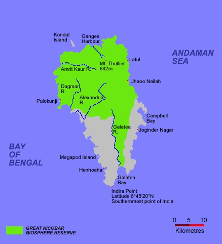
The island has several rivers, including the Alexandra, Amrit Kaur, Dogmar and Galathea. Virtually all rivers flow in a southern or southwesterly direction, which is indicative of the general slope of the terrain across the island. There are undulating hills throughout the island, with the main range running in a north-south orientation. Mount Thullier, which is part of this range, has the highest elevation of any point in the Nicobars, at 642 m above sea level.[4]
Indira Point (6°45’10″N and 93°49’36″E) is the southernmost point of the Great Nicobar Island and India itself. Indira Point subsided 4.25 m in the 26 December 2004 tsunami and the lighthouse there was damaged. The lighthouse was subsequently made functional.
Ecology
The island is part of the Nicobar Islands rain forests ecoregion. Plant communities include mangroves and coastal forests near the seashore, and evergreen and deciduous forests in the interior.[5]
The majority of the island is designated as the Great Nicobar Biosphere Reserve— home to many unique and endemic species of plants and animals including the Nicobar scrubfowl (Megapodius nicobariensis, a megapode bird), the edible-nest swiftlet (Aerodramus fuciphagus), the Nicobar long-tailed macaque (Macaca fascicularis umbrosa), saltwater crocodile (Crocodylus porosus), giant leatherback sea turtle (Dermochelys coriacea), Malayan box turtle, Nicobar tree shrew, reticulated python (Python reticulatus) and the giant robber crab (or coconut crab, Birgus latro).
Demography
The island is home to the Shompen people.[6]
Transportation
There is a 915m airstrip at Campbell Bay/Tenlaa on the East coast.[7][8]
- Seaport: At least one small shipping dock is located in Campbell Bay.
Naval air station
The INS Baaz naval air station, near Campbell Bay, is under the joint-services Andaman and Nicobar Command (ANC) of the Indian Armed Forces.[9] It is the southernmost air station of the Indian Armed Forces.[10]
Great Nicobar Development Plan
The Great Nicobar Development Plan is a massive infrastructure plan (including a major transshipment port, airport, and future strategic defense) for the southern tip of Great Nicobar Island, India. The plan has generated conflict concerning consequences of deforestation and giant leatherback sea turtle nesting sites. The plan was proposed on January 18, 2021 by an Indian policy think tank (NITI Aayog) informed by a feasibility report written by AECOM India Private Limited. Environmental Justice groups have pushed back claiming that the development plan would make it unlikely that the leatherback sea turtles would continue to nest in the Galathea Bay - as well as negatively impact the nomadic livelihoods of the indigenous Shompen people. The NITI Aayog plan also envisages 650,000 people to inhabit the island by 2050. Its current population is only around 8,500. In fact, the total population of the archipelago, composed of over 500 islands but of which around 40 are inhabited, is around 380,000. The increase in population is expected to impose a significant ecological pressure on the island and its surroundings.[11][12]
Indira Point
Indira Point is the name of the southernmost point of Republic of India. It is situated on Great Nicobar Island in the Nicobar Islands, which are located in the eastern Indian Ocean at 6°45’10″N and 93°49’36″E. This is not on the Indian mainland, but within the Union Territory of Andaman and Nicobar Islands. The name of the point was changed from Pygmalion Point on 18 October 1985[13] in commemoration of Indira Gandhi. It was formerly known by various names that include Pygmalion Point, Parsons Point, and for a brief period India Point.[14]
It is located 540 km and more than a day's sea voyage from Port Blair,[15] the capital city and main port of the Andaman and Nicobar Islands. It is approximately 163 km by sea from Sumatra, Indonesia.[14] Rondo Island, Indonesia's northernmost island in Sabang district of Aceh province of Sumatra, lies south of Indira point.[16] India and Indonesia are planning to collaborate to construct a port at Sabang to protect the channel between Great Nicobar Island and Rondo Island (c. May 2019).[17]
Indira Point lighthouse
Indira Point has a 35 m high cast iron (with red and white bands) lighthouse with 16 nautical miles range. The lighthouse has (RACON (Code 'G') ii DGPS station) with a 300 mm 4 panel revolving light inside a 2.5 m diameter lantern house (BBT). It is an important landmark on the international shipping lane Colombo-Singapore route via Malacca Strait that passes south of Indira Point. It also has a helipad.[18]
2004 tsunami
The tsunami which resulted from the Indian Ocean earthquake of 2004 inundated much of the area. This partly damaged the lighthouse, which subsided 4.25 m.[19] As a result of this subsidence, the coast retreated and the sea moved permanently inland. The lighthouse has since been repaired.[20]
The base of the lighthouse was 5 m above sea level when constructed in 1972. After the tsunami, the sea rose and the base was less than a metre above the sea level, showing over 4 meters of sea floor subsidence. It has been observed that the sea is slowly retreating back to its original position and the subsidence has decreased as the ocean floor slowly bounces back partially, a similar drop and rise due to crustal decompression and re compression was observed in the 2011 Tōhoku earthquake and tsunami on Honshu. Indira point was mostly submerged.
See also
- Andaman Sea
- List of extreme points of India
- Extreme points of Indonesia
Image gallery
 Map
Map Map of Great Nicobar Island
 Locator


References
- "Islandwise Area and Population – 2011 Census" (PDF). Government of Andaman.
- Registration Plate Numbers added to ISO Code
- "Wu Bei Zhi Map 17". Library of Congress.
- Shyam Singh Shashi (2005), Encyclopaedia of Indian Tribes, Anmol Publications Pvt Ltd, ISBN 81-7041-836-4,
... The main hill range runs from the north to south. Average height of the hills is 300m to 400m. The highest peak is Mount Thullier ...
- "Nicobar Islands rain forests". Terrestrial Ecoregions. World Wildlife Fund.
- Trivedi, Rajni; Sitalaximi, T.; Banerjee, Jheelam; Singh, Anamika; Sircar, P. K.; Kashyap, V. K. (March 2006). "Molecular insights into the origins of the Shompen, a declining population of the Nicobar archipelago". Journal of Human Genetics. 51 (3): 217–226. doi:10.1007/s10038-005-0349-2. PMID 16453062.
- "Missing Malaysia Airlines MH370 'Deliberately Diverted' Towards Andaman and Nicobar Islands: List of Unused Airports Where the Plane Possibly Landed [Photos]". International Business Times.
- "Runways – Campbell Bay Airport Campbell Bay, Andaman and Nicobar Islands, India".
- "Naval air station opened in Campbell Bay". The Hindu. 31 July 2012.
- "INS Baaz to keep hawk eye on threats in Indian Ocean Region". The Times of India. 1 August 2012. Archived from the original on 26 January 2013.
- NITI Aayog’s Vision for Great Nicobar Is at Great Odds With Islanders’ Reality, Rishika Pardika, Science, The Wire, 29/05/2021
- EJOLT. "Great Nicobar development plan, Nicobar islands, India | EJAtlas". Environmental Justice Atlas. Retrieved 19 April 2022.
- "Memories of Andaman and Nicobar Island on 18th October". Archived from the original on 2 February 2014. Retrieved 29 January 2014.
- Gupta, K.R.; Gupta, Amita (2006). Concise Encyclopaedia of India. p. 1209. ISBN 81-269-0640-5.
- Sharma, A.N. (2003). Tribal Development in Andaman Islands. p. 6. ISBN 81-7625-347-2.
- "Rondo Island, The Rich Uninhabited Island". Archived from the original on 3 November 2012. Retrieved 19 May 2018.
- India seeks to aid Indonesia in developing port in Aceh, Economic Times, 19 May 2018.
- "Welcome to INDIRA POINT LIGHT HOUSE". Directorate General of Lighthouses and Lightships. Archived from the original on 3 March 2013. Retrieved 26 December 2012.
- Bilham, Roger. "Indira Point Lighthouse Subsidence 2004–2005".
- "Defunct Indira Point Lighthouse RACON repaired". oneindia.in. Retrieved 26 December 2012.
- "Nicobar completely devastated" – from rediff.com
- 2001 Census – from the Andaman & Nicobar Police
- Great Nicobar Biosphere Reserve
 Andaman and Nicobar Islands travel guide from Wikivoyage
Authority control | |
|---|---|
| General |
|
| National libraries | |
На других языках
[de] Groß Nikobar
Groß Nikobar (englisch Great Nicobar, Hindi: .mw-parser-output .Deva{font-size:120%}@media all and (min-width:800px){.mw-parser-output .Deva{font-size:calc(120% - ((100vw - 800px)/80))}}@media all and (min-width:1000px){.mw-parser-output .Deva{font-size:100%}}बड़ा निकोबार, Baṛā Nikobār, nicobarisch: टोकिओंग लोंग oder Tokieong Long[1]) gehört zu der indischen Inselgruppe der Nikobaren im Golf von Bengalen, im Osten liegt die Andamanensee. Politisch gehört die Insel zum indischen Unionsterritorium Andamanen und Nikobaren.- [en] Great Nicobar Island
[fr] Grande Nicobar
La Grande Nicobar est la principale île de l'archipel des Nicobar, c'est le point le plus au Sud de l'Inde. Il y a près de 10 000 habitants.[it] Gran Nicobar
Gran Nicobar è un'isola facente parte delle Nicobare, nell'Oceano Indiano.[ru] Большой Никобар
Большо́й Никоба́р[1] (англ. Great Nicobar, хинди बड़ा निकोबार, кар: टोकिओंग लोंग) — крупнейший остров архипелага Никобарские острова. Территория острова 1045 км²[2], это более половины площади всего архипелага (1841 км²). Расположен в более 100 км к северо-западу от Суматры.Другой контент может иметь иную лицензию. Перед использованием материалов сайта WikiSort.org внимательно изучите правила лицензирования конкретных элементов наполнения сайта.
WikiSort.org - проект по пересортировке и дополнению контента Википедии