geo.wikisort.org - Island
Car Nicobar Tehsil (Pu in the local language) is one of three local administrative divisions of the Indian district of Nicobar, part of the Indian union territory of Andaman and Nicobar Islands.[3] It is a subdivision and also a tehsil, roughly equivalent to a county in its range of administrative powers. It is located in the Northern Nicobar Islands.
Native name: Pu | |
|---|---|
 Car Nicobar Location of Car Nicobar Island in India | |
| Geography | |
| Location | Bay of Bengal |
| Coordinates | 9.17°N 92.78°E |
| Archipelago | Nicobar Islands |
| Adjacent bodies of water | Indian Ocean |
| Total islands | 1 |
| Major islands |
|
| Area | 128.48 km2 (49.61 sq mi)[1] |
| Length | 15 km (9.3 mi) |
| Width | 12 km (7.5 mi) |
| Coastline | 51 km (31.7 mi) |
| Highest elevation | 10 m (30 ft) |
| Administration | |
| District | Nicobar |
| Island group | Nicobar Islands |
| Subdivisions of India | Car Nicobar Subdivision |
| Taluk | Car Nicobar Taluk |
| Largest settlement | Malacca (pop. 4200) |
| Demographics | |
| Population | 17841 (2014) |
| Pop. density | 138.86/km2 (359.65/sq mi) |
| Ethnic groups | Hindu, Nicobarese |
| Additional information | |
| Time zone |
|
| PIN | 744301 |
| Telephone code | 03192 |
| ISO code | IN-AN-00[2] |
| Official website | www |
| Literacy | 84.4% |
| Avg. summer temperature | 30.2 °C (86.4 °F) |
| Avg. winter temperature | 23.0 °C (73.4 °F) |
| Sex ratio | 1.2♂/♀ |
| Census Code | 35.638.0001 |
| Official Languages | Hindi, English, Tamil Car (regional) |
Administration
Politically, The Tehsil includes the islands of Car Nicobar, along neighboring Battimalv Island.
Image gallery
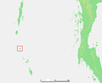 Location of Car Nicobar island

References
- "Islandwise Area and Population - 2011 Census" (PDF). Government of Andaman. Archived from the original (PDF) on 28 August 2017. Retrieved 3 May 2016.
- Registration Plate Numbers added to ISO Code
- "Village Code Directory: Andaman & Nicobar Islands" (PDF). Census of India. Retrieved 16 January 2011.
 Andaman and Nicobar Islands travel guide from Wikivoyage
This Andaman and Nicobar Islands location article is a stub. You can help Wikipedia by expanding it. |
Текст в блоке "Читать" взят с сайта "Википедия" и доступен по лицензии Creative Commons Attribution-ShareAlike; в отдельных случаях могут действовать дополнительные условия.
Другой контент может иметь иную лицензию. Перед использованием материалов сайта WikiSort.org внимательно изучите правила лицензирования конкретных элементов наполнения сайта.
Другой контент может иметь иную лицензию. Перед использованием материалов сайта WikiSort.org внимательно изучите правила лицензирования конкретных элементов наполнения сайта.
2019-2026
WikiSort.org - проект по пересортировке и дополнению контента Википедии
WikiSort.org - проект по пересортировке и дополнению контента Википедии