geo.wikisort.org - Island
Isla de Aves ([ˈis.la ð̞e̞ ˈa.β̞es]; Spanish for "Island of Birds" or "Birds Island"), or Aves Island, is a Federal Dependency of Venezuela. It has been the subject of numerous territorial disputes (now resolved) with the United States (through the Guano Islands Act of 1856), neighboring independent islands, such as Dominica, and European mother countries of surrounding dependent islands, such as the Netherlands, or the United Kingdom.
 Isla de Aves from space, 2001 | |
 Isla de Aves Location in the Caribbean | |
| Geography | |
|---|---|
| Location | Caribbean Sea |
| Coordinates | 15°40′18″N 63°36′59″W |
| Length | 376 m (1234 ft) |
| Width | 50 m (160 ft) |
| Highest elevation | 4 m (13 ft) |
| Administration | |
It is a part of the Aves Ridge and lies to the west of the Windward Islands chain at 15°40′18″N 63°36′59″W. It is 375 metres (1,230 ft) in length and never more than 50 metres (160 ft) in width, and rises 4 metres (13 ft) above the sea on a calm day. Under a particular interpretation of the United Nations Convention on the Law of the Sea, it could be classified as a rock, which would only give Venezuela a twelve nautical mile economic zone. However, Venezuela claims it is an island, which grants it a 200-nautical-mile (370 km) exclusive economic zone.[1] Mostly sand, a small portion has some scrubby vegetation. It is sometimes completely submerged during hurricanes. It is 185 kilometres (115 mi) southwest of the closest land, Montserrat, 225 kilometres (140 mi) west of Dominica and 547 kilometres (340 mi) north of the Venezuelan mainland.[2][3][4]
Impact of hurricanes
For some time the island has been in danger of eroding altogether, and Venezuelan authorities are considering ways to protect it, along with the territorial claims to the Caribbean Sea which radiate from Isla de Aves. The impact of Hurricane Allen in the 1980 Atlantic hurricane season divided it into two parts, but accretions of coral have subsequently reunited it. On August 17, 2007, the force of Hurricane Dean severely eroded the island.
Environment
The island is a resting and breeding place for seabirds and the green sea turtle (Chelonia mydas). Its low profile makes it a hazard to navigation, and many ships have been wrecked here.
Amateur radio "entity"
Aves Island is a particularly rare amateur radio "entity", under the ITU prefix YV0. A 2006 expedition by operators to the island required 14 years of planning.[citation needed] Though one member suffered a fatal heart attack, over 42,000 contacts were made during their week-long stay.[5]
History

The island was most likely discovered by Avaro Sanzze in 1584, though it was not settled. It was subsequently claimed for Great Britain, Spain, Portugal and the Netherlands. Throughout the 17th, 18th and 19th centuries, the inhabitants of the Dutch islands Saint Eustatius and Saba regularly visited Aves to collect turtle and bird eggs.[6]
In 1854, a U.S. captain discovered the abundant quantities of guano on Aves and systematic collection started not long after. Both the Dutch and Venezuelan authorities found out and protested. The Dutch sent a warship to Aves. Its captain found Americans loading guano. He informed them that the Dutch considered Aves to belong to the Netherlands.
The island was once again involved in controversy in 1857 when three Boston men, "Mesers Shelton, Samson and Tappan", were in a dispute with the Venezuelan government after they "annexed" the island "which they had discovered in an abandoned condition"; this was done in accordance with the recently passed United States Guano Islands Act.[7]
In the meantime, in 1859, the Administrator of St. Eustatius granted a concession to collect guano on Aves to ‘Edward Green, Kean & Co.’ in Baltimore at f. 2.50 per ton. He decided that “even though Aves was never permanently settled by the Dutch, the inhabitants of Statia and Saba had made use of the island longer than anyone can remember,” which “constituted proof of possession.” He gave a provisionary concession and asked the Governor in Curaçao to confirm. The Governor, meanwhile, had received a request to mine guano on Aves from a group of businessmen on Dutch St. Maarten, “who had assured themselves that Aves was recognized as a possession of the Dutch government.”
The Dutch authorities on Curaçao, under whom St. Eustatius and Saba fell, sat down with the Venezuelans and together decided to find a mutually acceptable sovereign to decide about the ownership of Aves Island. The Queen of Spain was accepted by both parties, and in 1865 Isabella II ruled on the issue, deciding in favor of the Venezuelans.
However, Isabella's judgment acknowledged the time honored rights of the inhabitants of the Dutch islands St. Eustatius, Saba and St. Maarten to fish in the waters around Aves. As this was the main issue the Dutch had, they accepted the ruling. Later, some Dutch historians argued that Isabella's advisors could have mixed up Aves with Las Aves Archipelago lying between Bonaire and Los Roques, just off the coast of Venezuela.
From 1878 to 1912, the island was again occupied by American guano miners until supplies were exhausted.
Isla de Aves was included in Venezuela's territorial reorganization done by President Joaquín Crespo in 1895. By 1905, Isla de Aves was a municipality called "Municipio Oriental" part of Colón Federal Territory.
In 1950, a Venezuelan Navy fleet consisting of two patrol boats and one transport boat were sent to take control of the island with a group of soldiers.
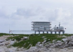
On June 2, 1978, the Venezuelan Navy were sent to set up a scientific naval base named Simón Bolívar on the lee (west) side near the southern tip of the island, constructed as a platform built on stilts partially in the water, which was permanently inhabited by a group of scientists and military personnel.
United States—Venezuela Maritime Boundary Treaty
On March 28, 1978, Venezuela, using Aves Island as its reference, agreed to its maritime borders with the U.S. between Aves Island and Puerto Rico in the United States–Venezuela Maritime Boundary Treaty; this treaty came into force on 24 November 1980 after it was ratified by both parties.
The island is the closest Venezuelan territory to the United States, approximately 163 miles (262 km) from the U.S. island of St. Croix.
Agreement with France
On June 17, 1980, Venezuela agreed with France that longitude 62°48′52″ W should be the maritime boundary between Aves Island and Guadeloupe and Martinique.
2006 Dominica and Venezuela informal agreement
During a visit to Venezuela, Dominica’s Prime Minister Roosevelt Skerrit, in June 2006, stated that Aves Island belongs to Venezuela, ending the territorial claim.[8]
Historical maps
This article needs additional citations for verification. (April 2009) |
 1647
1647 1887
1887 1970
1970 Before Hurricane Allen (1980)
 After Hurricane Allen (1980)


See also
- Ankoko Island (another disputed territory involving Venezuela)
- Exclusive economic zone
- Federal Dependencies of Venezuela
- List of marine molluscs of Venezuela
- List of sponges of Venezuela
- List of territorial disputes
References
- República de Venezuela y República Dominicana. 1981: Tratado de relimitación de áreas marinas y submarinas entre la República de Venezuela y República Dominicana. Ministerio de la Defensa. Caracas. 8p.
- Vila, Marco Aurelio. 1967: Aspectos geográficos de las Dependencias Federales. Corporación Venezolana de Fomento. Caracas. 115p.
- Cervigon, Fernando. 1995: Las Dependencias Federales. Academia Nacional de la Historia. Caracas. 193p.
- Hernández Caballero, Serafín (Editor). 1998: Gran Enciclopedia de Venezuela. Editorial Globe, C.A. Caracas. 10 volúmenes. ISBN 980-6427-00-9 ISBN 980-6427-10-6
- "The ARRL Letter". April 21, 2006.
- González Oropeza, Hermann. y Donis Ríos, Manuel. 1989: Historia de las fronteras de Venezuela. Cuadernos Lagoven. Lagoven, S.A. Caracas. 180p. ISBN 980-259-257-9
- "Our Claim Against Venezuela: Page 5". The New York Times. 26 June 1857.
- Viceministerio de Gestión Comunicacional
External links
- Bird Island: time to act – Editorial on the Commonwealth of Dominica taking steps to reclaim sovereignty over the island.
- Fontaine, Thomson (October 21, 2002). "Aves Island a Strategic Island in the Caribbean Sea: Should Dominica Stake a Claim to the Island?". The Dominican.
- 2006 amateur radio activity, including pictures
- YW0A 4M5DX Group Amateur Radio DX Pedition to Aves Island 2014
- YX0V Amateur Radio DX Pedition Aves Island 2016
Articles and papers
- "Island' talk for Caricom, Venezuela – (July 7, 2006) – Barbados NationNews
- OECS searching for Bird Island solution – (March 16, 2006) – Caribbean Net News
- Shock over Bird Island – (November 10, 2005) – Barbados Advocate News
- Drama over Bird Island – (November 10, 2005) – Barbados Advocate News
- OECS raps Caracas' claim to island – (November 9, 2005) – Barbados NationNews
- Caricom to meet over Aves Island – (October 24, 2005) – Barbados NationNews
- History proves Venezuelan ownership of Isla de Aves
- VicePresident Rangel thinks that the "empire" is behind claim to Aves Island
Administrative divisions of Venezuela | ||
|---|---|---|
| Capital District |
| |
| States |
| |
| Federal Dependencies |
| |
| Regions |
| |
| Claimed |
| |
Dominica articles | |||
|---|---|---|---|
| History |
|  | |
| Geography |
| ||
| Politics |
| ||
| Economy |
| ||
| Society |
| ||
| |||
Authority control | |
|---|---|
| General |
|
| National libraries | |
На других языках
[de] Aves (Insel)
Aves (spanisch Isla de Aves, „Vogel-Insel“), auch Bird Island, ist eine von Venezuela besetzte Insel im Karibischen Meer. Administrativ gehört die Insel zu den venezolanischen Bundesterritorien (Dependencias Federales). Venezuelas Ansprüche auf die Insel bzw. die Umgebung werden von mehreren Anrainern bezweifelt (Frankreich, Niederlande, USA und ehemals Dominica).[1]- [en] Isla de Aves
[fr] Isla de Aves
La Isla de Aves (en français : île aux oiseaux) est une petite île des Antilles de 375 m de long pour 50 m de large. Elle se situe à 205 km à l'ouest de la Guadeloupe et à 230 km de la Dominique. Elle fait partie des Dépendances fédérales du Venezuela.[it] Aves (isola)
L'isola di Aves (spagnolo: Isla de Aves) è una piccola e remota isola situata nel mar dei Caraibi, a .mw-parser-output .geo-default,.mw-parser-output .geo-dms,.mw-parser-output .geo-dec{display:inline}.mw-parser-output .geo-nondefault,.mw-parser-output .geo-multi-punct{display:none}.mw-parser-output .latitude,.mw-parser-output .longitude{white-space:nowrap}.mw-parser-output .geo{}body.skin-vector .mw-parser-output #coordinates{font-size:85%;line-height:1.5em;position:absolute;right:0;top:0;white-space:nowrap}15°40′18″N 63°36′59″W e a 110 km a ovest delle isole di Guadalupa e Dominica. Lunga non più di 375 metri e larga al massimo 50 m, il punto di massima altezza, in un giorno di bonaccia, è di soli 4 metri; la sua superficie è di circa 4,5 ha. In certi casi, durante le tempeste più violente, l'isola viene completamente sommersa dalle acque[1][2][3][4]. Formata da sabbia e povera di vegetazione, l'isola si trova in una zona pericolosa per la navigazione, come testimoniato dalle numerose barche naufragate lungo la costa. Non va confusa con le isole Las Aves, presso il gruppo de Los Roques, situate più in prossimità delle coste venezuelane.[ru] Авес
А́вес[1][2] (исп. Isla de Aves — «Птичий остров») — крошечный островок в Карибском море, принадлежащий Венесуэле. Расположен к западу от Наветренных островов.Другой контент может иметь иную лицензию. Перед использованием материалов сайта WikiSort.org внимательно изучите правила лицензирования конкретных элементов наполнения сайта.
WikiSort.org - проект по пересортировке и дополнению контента Википедии