geo.wikisort.org - Island
Sint Eustatius (Dutch: Sint Eustatius, pronounced [sɪnt øːˈstaːtsijʏs] (![]() listen)),[7] also known locally as Statia (/ˈsteɪʃə/),[8] is an island in the Caribbean. It is a special municipality (officially "public body") of the Netherlands.[9]
listen)),[7] also known locally as Statia (/ˈsteɪʃə/),[8] is an island in the Caribbean. It is a special municipality (officially "public body") of the Netherlands.[9]
This article needs additional citations for verification. (July 2022) |
Sint Eustatius | |
|---|---|
Special municipality of the Netherlands | |
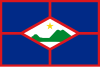 Flag  Coat of arms | |
| Motto(s): | |
| Anthem: "Golden Rock" | |
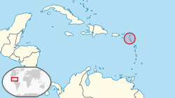 Location of Sint Eustatius (circled in red) in the Caribbean | |
 | |
| Coordinates: 17°29′N 62°59′W | |
| Country | |
| Overseas region | Caribbean Netherlands |
| Incorporated into the Netherlands | 10 October 2010 (dissolution of the Netherlands Antilles) |
| Capital (and largest city) | Oranjestad |
| Government (see Politics of the Netherlands) | |
| • Lt. Governor | Alida Francis (Government commissioner)[1] |
| Area | |
| • Total | 21 km2 (8 sq mi) |
| Population (1 January 2019)[3] | |
| • Total | 3,138 |
| • Density | 150/km2 (400/sq mi) |
| Demonym(s) | St. Eustatian; Statian |
| Languages | |
| • Official | English[4] and Dutch |
| Time zone | UTC−4 (AST) |
| Calling code | +599-3 |
| ISO 3166 code | BQ-SE, NL-BQ3 |
| Currency | United States dollar ($) (USD) |
| Internet TLD |
|
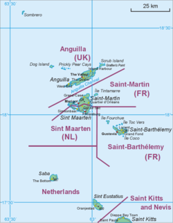
The island lies in the northern Leeward Islands portion of the West Indies, southeast of the Virgin Islands. Sint Eustatius is immediately to the northwest of Saint Kitts, and to the southeast of Saba. The regional capital is Oranjestad. The island has an area of 21 square kilometres (8.1 sq mi).[2] Travellers to the island by air arrive through F. D. Roosevelt Airport. Formerly part of the Netherlands Antilles, Sint Eustatius became a special municipality of the Netherlands on 10 October 2010.[10] Together with Bonaire and Saba it forms the BES islands.
The name of the island, "Sint Eustatius", is the Dutch name for Saint Eustace (also spelled Eustachius or Eustathius), a legendary Christian martyr, known in Spanish as San Eustaquio and in Portuguese as Santo Eustáquio or Santo Eustácio.
History


The earliest inhabitants were Caribs[11] believed to have come from the Amazon basin (South America) and migrated north from Venezuela[11] via the Lesser Antilles.[11] In the early 20th century, settlement traces were discovered at Golden Rock and Orange Bay.
Multiple pre-Columbian sites have been found on the island, most notably the site referred to as the "Golden Rock Site".[12] It is thought that the island was likely seen by Christopher Columbus in 1493.[citation needed] From the first European settlement, in the 17th century until the early 19th century, St. Eustatius changed hands twenty-one times between the Netherlands, Britain, and France.
In 1636, the chamber of Zeeland of the Dutch West India Company took possession of the island, reported to be uninhabited at the time. In 1678 the islands of St. Eustatius, Sint Maarten and Saba were under the direct command of the Dutch West India Company, with a commander stationed on St. Eustatius to govern all three. At the time, the island was of some importance for the cultivation of tobacco and sugar.
Slave trade and free port
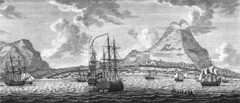
![17th-century Fort Oranje [nl], with the island of Saba visible in the distance](http://upload.wikimedia.org/wikipedia/commons/3/39/Fort_Oranje.jpg)
In the 18th century, St. Eustatius's geographical placement in the middle of Danish (Virgin Islands), British (Jamaica, St. Kitts, Barbados, Antigua), French (St. Domingue, Ste. Lucie, Martinique, Guadeloupe) and Spanish (Cuba, Santo Domingo, Puerto Rico) territories—its large harborage, neutrality and status from 1756[8] as a free port with no customs duties were all factors in it becoming a major point of transhipment of goods, and a locus for trade in contraband.[8][13] St. Eustatius's economy flourished under the Dutch by ignoring the monopolistic trade restrictions of the British, French and Spanish islands; it became known as The Golden Rock. Edmund Burke said of the island in 1781:
It has no produce, no fortifications for its defence, nor martial spirit nor military regulations ... Its utility was its defence. The universality of its use, the neutrality of its nature was its security and its safeguard. Its proprietors had, in the spirit of commerce, made it an emporium for all the world. ... Its wealth was prodigious, arising from its industry and the nature of its commerce.[8]
"First Salute"

The island sold arms and ammunition to anyone willing to pay, and it was therefore one of the few places from which the young United States could obtain military stores. The good relationship between St. Eustatius and the United States resulted in the noted "First Salute".
On 16 November 1776, the 14-gun American brig Andrew Doria commanded by Captain Isaiah Robinson[14][13] sailed, flying the Continental Colors of the fledgling United States, into the anchorage below St. Eustatius' Fort Oranje. Robinson announced his arrival by firing a thirteen gun salute, one gun for each of the thirteen American colonies in rebellion against Britain. Governor Johannes de Graaff replied with an eleven-gun salute from the cannons of Fort Oranje (international protocol required two guns fewer to acknowledge a sovereign flag). It was the first international acknowledgment of American independence.[Note 1] The Andrew Doria had arrived to purchase munitions for the American Revolutionary forces. She was carrying a copy of the Declaration of Independence which was presented to Governor De Graaff. An earlier copy had been captured by the British on its way to Holland. It was wrapped in documents that the British believed to be a strange cipher, but were actually written in Yiddish, addressed to Jewish merchants in Holland.

President Franklin D. Roosevelt visited St. Eustatius for two hours on 27 February 1939 on USS Houston to recognise the importance of the 1776 "First Salute". He presented a large brass plaque to St. Eustatius, displayed today under a flagpole atop the walls of Fort Oranje, reading:
"In commemoration to the salute to the flag of the United States, Fired in this fort November 16. 1776, By order of Johannes de Graaff, Governor of Saint Eustatius, In reply to a National Gun-Salute, Fired by the United States Brig of War Andrew Doria, Under Captain Isaiah Robinson of the Continental Navy, Here the sovereignty of the United States of America was first formally acknowledged to a national vessel by a foreign official. Presented by Franklin Delano Roosevelt, President of the United States of America"
The recognition provided the title for Barbara W. Tuchman's 1988 book The First Salute: A View of the American Revolution.
The British took the Andrew Doria incident seriously, and protested bitterly against the continuous trade between the United Colonies and St. Eustatius. In 1778, Lord Stormont claimed in Parliament that, "if Sint Eustatius had sunk into the sea three years before, the United Kingdom would already have dealt with George Washington". Nearly half of all American Revolutionary military supplies were obtained through St. Eustatius. Nearly all American communications to Europe first passed through the island. The trade between St. Eustatius and the United States was the main reason for the Fourth Anglo-Dutch War of 1780–1784.[13] Notably, the British Admiral George Brydges Rodney, having occupied the island for Great Britain in 1781, urged the commander of the landing troops, Major-General Sir John Vaughan, to seize "Mr. Smith at the house of Jones – they (the Jews of St. Eustatius, Caribbean Antilles)[15] cannot be too soon taken care of – they are notorious in the cause of America and France." The war was disastrous for the Dutch economy.

Britain declared war on the Republic of the Seven United Netherlands on 20 December 1780. Even before officially declaring war, Britain had outfitted a massive battle fleet to take and destroy the weapons depot and vital commercial centre that St. Eustatius had become. British Admiral George Brydges Rodney was appointed the commander of the battle fleet. 3 February 1781, the massive fleet of 15 ships of the line and numerous smaller ships transporting over 3,000 soldiers appeared before St. Eustatius prepared to invade. Governor De Graaff did not know about the declaration of war. Rodney offered De Graaff a bloodless surrender to his superior force. Rodney had over 1,000 cannon to De Graaff's one dozen cannon and a garrison of sixty men. De Graaff surrendered the island, but first fired two rounds as a show of resistance in honour of Dutch Admiral Lodewijk van Bylandt, who commanded a ship of the Dutch Navy which was in the harbor.[8] Ten months later, the island was conquered by the French, allies of the Dutch Republic in the war. The Dutch regained control over the looted and plundered island in 1784.
At its peak, St. Eustatius may have had a largely transient population of about 10,000 people. Most were engaged in commercial and maritime interests. A census list of 1790 gives a total population (free and enslaved people combined) of 8,124. Commerce revived after the British left. Many of the merchants (including the Jews) returned to the island. However, French and British occupations from 1795 disrupted trade and also the North-Americans, now globally recognised as an independent nation, had meanwhile developed their own trading network and did not need St. Eustatius anymore. The island was eclipsed by other Dutch ports, such as those on the islands of Curaçao and Sint Maarten. During the last years of the 18th century Statia developed trade in bay rum. The economy declined in the early 19th century. From about 1795 the population declined, dropping to 921 in 1948.
Jewish population
The first record of Jews on St. Eustatius dates to 1660. The Jews were mainly merchants with significant international trading and maritime commercial ties. Jews were captains, owners or co-owners with Christian partners, of significant numbers of ships originating out of St. Eustatius. A few were island plantation owners. Jews were estimated[by whom?] to have comprised at least 10% of the permanent population of St. Eustatius.[16]
Ten days after the island surrendered to the British on 3 February 1781, Rodney ordered that the entire Jewish male adult population assemble for him. They were rounded up and thirty one heads of families were summarily deported to St. Kitts without word or mercy to their dependents. The choice of exiling the Jews to St. Kitts was significant. The nearby British Island of Nevis had a large Jewish population and an established community capable of aiding the refugees. St. Kitts did not have any Jewish community or population. The other seventy-one were locked up in the weighing house in Lower Town where they were held for three days.
Expulsion of Americans followed on 23 February, of merchants from Amsterdam on 24 February and of other Dutch citizens and Frenchmen on 5 March. The crews of the Dutch ships Rodney took were sent to St. Kitts for imprisonment – after first stripping them of all their belongings. Because of their maltreatment, many perished. The Jews were well received on St. Kitts – where many knew them as their respected business partners. They were supported in their protest against their deportation and it proved successful. They were allowed to return to St. Eustatius after a few weeks to observe all their property being sold at small fractions of the original value after having been confiscated by Rodney.
The resentment the British felt for the population of this island that helped the Americans to defeat them translated in a harsh treatment of the inhabitants. There were numerous complaints about "individuals of both sexes being halted in the streets and being body searched in a most scandalous way."[17] Pieter Runnels, an eighty-year-old member of the island council and captain of the civic guard, did not survive the rough treatment he received aboard Rodney's ship. He, a member of one of the island's oldest-established families, became the only civilian casualty of the British occupation. British soldiers prevented the family and others paying their last respects at his funeral from using the water from the family's own cistern.
The tomb of former governor Jan de Windt was broken open by British soldiers, all the silver decorations stolen off the caskets, and the bodies of the governor and his wife exposed, without any of Rodney's officers interfering.
Rodney singled out the Jews: the harshness was reserved for them alone. He did not do the same to French, Dutch, Spanish or even the American merchants on the island. He permitted the French to leave with all their possessions. Rodney was concerned that his unprecedented behavior would be repeated upon British islands by French forces when events were different. However, Governor De Graaff was also deported.
As he did with all other warehouses, Rodney confiscated the Jewish warehouses, looted Jewish personal possessions, even cutting the lining of their clothes to find money hidden in there. When Rodney realized that the Jews might be hiding additional treasure, he dug up the Jewish cemetery.[18]
Later, in February 1782, Edmund Burke, the leading opposition member of the Whig Party, upon learning of Rodney's actions in St. Eustatius, rose to condemn Rodney's anti-Semitic, avaricious vindictiveness in Parliament:
"...and a sentence of general beggary pronounced in one moment upon a whole people. A cruelty unheard of in Europe for many years… The persecution was begun with the people whom of all others it ought to be the care and the wish of human nations to protect, the Jews… the links of communication, the mercantile chain… the conductors by which credit was transmitted through the world…a resolution taken (by the British conquerors) to banish this unhappy people from the island. They suffered in common with the rest of the inhabitants, the loss of their merchandise, their bills, their houses, and their provisions; and after this they were ordered to quit the island, and only one day was given them for preparation; they petitioned, they remonstrated against so hard a sentence, but in vain; it was irrevocable." [19]
The synagogue and the cemetery

From about 1815, when there was no longer a viable Jewish community using and maintaining the synagogue on St. Eustatius, it gradually fell into ruin.
The synagogue building, known as Honen Dalim, (He who is charitable to the Poor) was constructed in 1737. Permission for building the synagogue came from the Dutch West India Company, additional funding came from the Jewish community on Curaçao. Permission was conditional on the fact that the Jewish house of worship would be sited where "the exercise of their (Jewish) religious duties would not molest those of the Gentiles".[20] The building is located off a small lane called Synagogue Path, away from the main street. The synagogue attested to the wealth of the Jews of St. Eustatius and their influence on the island.[21]

In 2001, its walls were restored as part of the Historic Core Restoration Project, although there are no known images showing what the synagogue looked like when still in use, so that archeological research is attempting to restore the structure to the best estimate of its former condition. The grounds include a Jewish ritual bath (mikveh) and an oven used on Passover.
A restored and respectfully maintained Jewish cemetery is located adjacent to the Old Church Cemetery, at the top of Oranjestad, Sint Eustatius.
Rodney's delayed departure, 1781
The wealth Rodney and General Vaughan discovered on St. Eustatius exceeded their expectations. There were 130 merchantmen in the bay as well as the Dutch frigate and five smaller American armed merchantmen. In total the value of goods seized, including a very rich Dutch convoy captured off Sombrero, was estimated to be well in excess of £3 million.[22] On 5 February 1781 Rodney and Vaughan signed an agreement stating that all goods taken belonged to the Crown.[23] Rodney and Vaughan, by British custom, expected to personally receive a significant share of the captured wealth from the King once it reached England. Instead of delegating the task of sorting through and estimating the value of the confiscated property Rodney and Vaughan delayed their departure and oversaw this themselves.
Rodney, privately, wrote to his family with promises of a new London home. To his daughter he promised "the best harpsichord money can purchase". He confidently wrote of a marriage settlement for one of his sons and a soon-to-be-purchased commission in the Foot Guards for another son. He wrote of a dowry for his daughter to marry the Earl of Oxford. He noted he would have enough to pay off the young prospective bridegroom's debts.
The excessive amount of time Rodney spent on St. Eustatius led to allegations that Rodney and Vaughan had neglected their military duties. In particular, Viscount Samuel Hood suggested that Rodney should have sailed to intercept a French fleet under Lieutenant général de Grasse, traveling to Martinique.[24] The French fleet instead turned north and headed for the Chesapeake Bay.

Rodney's delay at St. Eustatius was not the first time he had taken the opportunity to capture prizes over the immediate and expeditious fulfilment of his military duties. During the Seven Years' War of 1756–1763, Rodney had delayed transporting Major General Jeffrey Amherst in order to pursue prizes. Later, Rodney had been ordered to Barbados to link up with Admiral Sir George Peacock and the Earl of Albemarle for an attack on Cuba. Instead, Rodney sent valuable ships off in search of prizes. In 1762, after the fall of Martinique, Rodney quarrelled with the army over prize-money. During Rodney's command in Jamaica (1771–1774) the Earl of Sandwich feared that Rodney might provoke a war with Spain to obtain prize money.[25]
Rodney further weakened his fleet earlier by sending a strong defending force to England to accompany his treasure ships. After months on St. Eustatius, capturing additional merchants and treasure, Rodney was prevailed upon to send part of his fleet north to aid General Cornwallis and British armed forces fighting the Americans. He did not dispatch the bulk of his fleet from St. Eustatius until July/August 1781. The ships arrived too late to affect the events that were taking place in North America.

Outside of the Chesapeake Bay, a much stronger combined French fleet under Grasse defeated the weakened British fleet (5 September 1781). The battle between Grasse and Rear Admiral Sir Thomas Graves became known as the Battle of the Chesapeake or the Battle of the Capes, one of the most pivotal battles in history.[26]
British General Cornwallis, trapped at Yorktown, Virginia, desperately awaited much-needed supplies and men that Rodney would have brought. American General George Washington, with French siege-artillery and supporting forces, closed the vise from the land side. Cornwallis could not be aided from the sea because of the British naval defeat. The French controlled the Bay. Cornwallis' predicament linked directly to Rodney's failure to depart St. Eustatius promptly following its capture and the destruction of the military stores there. Cornwallis had no choice, and surrendered on 19 October 1781; the American Revolutionary war was over, and the Americans had won, partially due to Rodney's anti-Semitic and avaricious delays.[27][28]
A series of disastrous French and British occupations of Sint Eustatius from 1795 to 1815 diverted trade to the occupiers' islands. St. Eustatius' economy collapsed, and the merchants, including the Jews left. St. Eustatius reverted permanently to Dutch control from 1816.
Slave Revolt of 1848
After 1848, slavery only existed on the Dutch and Danish Eastern Caribbean islands, which caused unrest on the islands colonized by the Netherlands. As a result, a proclamation declared on 6 June 1848 on Sint Maarten that enslaved Africans would be treated as free persons.[29]
Unrest also arose on Sint Eustatius. On 12 June 1848, a group of free and enslaved Africans gathered in front of Lieutenant Governor Johannes de Veer's home demanding their declaration of liberty, increased rations, and more free hours. The Island Governor addressed the group, but it persisted in its demands. The militia was mobilized and, after consultation with the Colonial Council and the main residents, an attack was decided by the Lieutenant Governor. After another warning to leave the city or otherwise experience the consequences, fire was opened on the group. The insurgents fled the city, leaving two or three seriously injured. From a hill just outside the city they pelted the militia with stones and pieces of rock. A group of 35 shooters stormed the hill, killing two insurgents and injuring several. The six leaders of the uprising were exiled from the island and transferred to Curaçao. Thomas Dupersoy, a free African, is considered the chief leader of the uprising. One of the other leaders sent a death notice to his "owner" in 1851. After the uprising, the largest plantation owners on Sint Eustatius decided to give their enslaved workers a certain wage for fear of repetition of revolt.[30]
Abolition of slavery
In 1863 slavery was officially abolished in the Netherlands. The Dutch were among the last to abolish slavery.[31] The freed slaves no longer wanted to live in the field and moved to the city. Due to a lack of trade, the bay of Sint Eustatius underwent a recession. Natural disasters such as the hurricane of September 1928 and May 1929 accelerated the process of economic decline on the island.
Dissolution of the Netherlands Antilles
Sint Eustatius became a member of the Netherlands Antilles when that grouping was created in 1954. Between 2000 and 2005 the member islands of the Netherlands Antilles voted on their future status. In a referendum on 8 April 2005, 77% of Sint Eustatius voters voted to remain within the Netherlands Antilles, compared to 21% who voted for closer ties with the Netherlands. None of the other islands voted to remain.
After the other islands decided to leave, ending the Netherlands Antilles, the island council opted to become a special municipality of the Netherlands, like Saba and Bonaire. This process was completed in October 2010.[13] In 2011 the island officially adopted the US dollar as its currency.[32]
Geography


Sint Eustatius is 6 miles (10 km) long and up to 3 miles (5 km) wide.[33] Topographically, the island is saddle-shaped, with the 602-meter-high dormant volcano Quill (Mount Mazinga), (from Dutch kuil, meaning 'pit'—originally referring to its crater) to the southeast and the smaller summits of Signal Hill/Little Mountain (or Bergje) and Boven Mountain to the northwest. The Quill crater is a popular tourist attraction on the island. The bulk of the island's population lives in the flat saddle between the two elevated areas, which forms the centre of the island.[33]
Climate
St. Eustatius has a tropical monsoon climate. Tropical storms and hurricanes are common. The Atlantic hurricane season runs from 1 June to 30 November, sharply peaking from late August through September. Tropical Cyclone Climatology
Nature
As St. Eustatius is a volcanic island and very small, all of the beaches on the island are made up of black volcanic sand. These volcanic sands, especially one of the more popular nesting beaches called Zeelandia, are very important nesting sites for several endangered sea turtles such as: the green turtle, leatherback, loggerhead and hawksbill.[34] Sint Eustatius is home to one of the last remaining populations of the critically endangered Lesser Antillean iguana (Iguana delicatissima).[35] The population was strongly affected during the high-intensity hurricane year of 2017, with especially Hurricane Maria, during which the population reduced by 25%. [36]
National parks
Sint Eustatius has three nature parks – on land and at sea: the Sint Eustatius National Marine Park, Quill/Boven National Park, and Miriam Schmidt Botanical Garden. Two of them have national park status. These areas have been designated as important bird areas. The nature parks are maintained by the St Eustatius National Parks Foundation (STENAPA).[37]
Archaeology
Due to its turbulent history, Sint Eustatius is rich in archaeological sites. Nearly 300 sites have been documented.[38] The island is said to have the highest concentration of archaeological sites of any area of comparable size.[39] In the 1920s, J.P.B. Josselin de Jong conducted archaeological research into Saladoid sites on the island and in the 1980s a great deal of research was done by archaeologist Aad Versteeg of Leiden University. Around 1981, under the direction of archaeologist Norman F. Barka, the College of William & Mary in Williamsburg, Virginia also started archaeological research on Sint Eustatius. The documented archaeological sites include prehistoric sites, plantations, military sites, commercial trading sites (including shipwrecks), and urban sites (churches, government buildings, cemeteries, residences). The St. Eustatius Center for Archaeological Research (SECAR) has been conducting archaeological research on the island since 2004.[40]
In June 2021, SECAR became involved in protests against excavations at an 18th-century slave cemetery on the island. The Ubuntu Connected Front and other concerned citizens of Sint Eustatius denounced the non-involvement of the community in the excavation process through a petition and letters to the government.[41][42][43] The majority of the population on St. Eustatius are of African descent. Participation in cultural heritage, i.e. involving the community whose ancestors are being excavated, is good practice in contemporary archaeology.[44] Archaeological excavations on St. Eustatius apparently fall under the old Monuments Act for the BES islands[45] that is very brief on these issues. The 2016 Dutch Heritage Act[46] offers more protection for cultural heritage. The Committee on Kingdom Relations asked Secretary of State Raymond Knops questions about the matter.[47] A Statia Heritage and Research Commission (SHRC) set up by the government of St. Eustatius is investigating the allegations of the protest groups and should come up with recommendations.[48]

Demography
Population
As of January 2019, the population is 3,138,[3] with a population density of 150 inhabitants per square kilometre.

Sint Eustatius
Language
The official language is Dutch, but English is the "language of everyday life" on the island and education is solely in English.[49] A local English-based creole is also spoken informally. More than 52% of the population speak more than one language. The most widely spoken languages are English (92.7%), Dutch (36%), Spanish (33.8%) and Papiamento (20.8%).
Religion
Sint Eustatius is predominantly a Christian territory. The main denominations are Methodist 28.6%, Catholics 23.7%, Adventist 17.8%, Pentecostal 7.2% and Anglicans 2.6%.[50]
Religion in Sint Eustatius (2018):[50]

Economy

In the 18th century, "Statia" was the most important Dutch island in the Caribbean and was a center of great wealth from trading. At this time it was known as the "Golden Rock" because of its immense wealth. A very large number of warehouses lined the road that runs along Oranje Bay; most (but not all) of these warehouses are now ruined and some of the ruins are partially underwater.
A French occupation in 1795 was the beginning of the end of great prosperity for Sint Eustatius.
According to the Sint Eustatius government website, "Statia's economy is stable and well placed to grow in the near future. With practically no unemployment and a skilled workforce, we have a infrastructure in place to ensure sustained growth."[51] The government itself is the largest employer on the island, and the oil terminal owned by NuStar Energy is the largest private employer on the island.[52]
Energy and water

Statia Utility Company N.V. provides electricity to the island, as well as drinking water per truck and on part of the island by a water network. The electricity supply is rapidly being made green. Until 2016 all electricity was produced by diesel generators. In March 2016 the first phase of the solar park with 1.89 MWp capacity became operational, covering 23% of entire electricity demand. In November 2017[53] another 2.15 MWp was added, totaling 14,345 solar panels, with 4.1 MW capacity and a yearly production of 6.4 GWh. The solar park includes lithium ion batteries of 5.9 MWh size. These provide power for grid stability, as well as energy shifting. On a sunny day the diesel generators are switched off from 9 a.m. to 8 pm. This is made possible by grid forming inverters produced by SMA. This is one of the first such solar parks in the world, and provides 40% to 50% of the island's electricity.
Education
Dutch government policy towards St. Eustatius and other SSS islands promoted English medium education. Sint Eustatius has bilingual English-Dutch education.[54]
Gwendoline van Putten School (GVP) is a secondary school on the island.
Other schools include: Golden Rock School, Gov. de Graaff School, Methodist School, SDA School.[55]
Sports
The most popular sports on Sint Eustatius are football,[56] futsal,[57][58] softball,[59] basketball, swimming and volleyball. Due to the small population, there are few sport associations. One of them, the Sint Eustatius Volleyball Association, is a member of ECVA and NORCECA. Currently St. Eustatius is a non-active member of the Caribbean zone of Pony Baseball and Softball leagues.
Famous Statians
- Antony Beaujon (c. 1763–1805), colonial governor
- Gerald Berkel (b. 1969), politician
- Black Harry (18th century), methodist preacher
- Kizzy (b. 1979), artist
- Lolita Euson (1914–1994), writer and poet
- Ziggi Recado (b. 1981), artist
- Shirma Rouse, singer
See also
- Caribbean Netherlands
- Dissolution of the Netherlands Antilles
- Governors of Sint Eustatius, Saba and Sint Maarten
- F. D. Roosevelt Airport
- Great Hurricane of 1780
- Index of Netherlands Antilles-related articles
Notes
- The first salute to the Colors may have occurred one month earlier. It is debatable if a Colonial merchantman received a formal salute from Fort Frederik on the Danish island of St Croix (The birth of our Flag page 13 published 1921) and (Americas Library) Translated from the Danish Wikipedia article on Frederiksted "Frederiksted is a town on St Croix in the U.S. Virgin Islands which were previously the Danish West Indies. .. The town is dominated by the red and white Fort Frederik from the 1750s. The fort has special meaning to both USA and Denmark-Norway. It was from here that the first foreign salute of recognition of USA independence was given in 1776."
References
- "Benoeming regeringscommissaris en plaatsvervanger Sint Eustatius". Rijksoverheid (in Dutch). 18 June 2021. Retrieved 19 December 2021.
- "Waaruit bestaat het Koninkrijk der Nederlanden?". Rijksoverheid (in Dutch). 19 May 2015. Retrieved 5 April 2022.
- "CBS Statline".
- English can be used in relations with the government, see, Invoeringswet openbare lichamen Bonaire, Sint Eustatius en Saba (in Dutch) – via Overheid.nl.
- "BQ – Bonaire, Sint Eustatius and Saba". ISO. Archived from the original on 17 June 2016. Retrieved 29 August 2014.
- "Delegation Record for .BQ". IANA. 20 December 2010. Archived from the original on 29 May 2012. Retrieved 30 December 2010.
- Mangold, Max. Duden – Das Aussprachewörterbuch. In: Der Duden in zwölf Bänden, Band 6. 7. Auflage. Berlin: Dudenverlag; Mannheim : Institut für Deutsche Sprache, 2015, Seite 786.
- Tuchman, Barbara W. (1988). The First Salute: A View of the American Revolution. New York: Ballantine Books.
- Wet openbare lichamen Bonaire, Sint Eustatius en Saba [Law on the public bodies of Bonaire, Sint Eustatius and Saba] (in Dutch) – via Overheid.nl.
- "Antillen opgeheven op 10-10-2010". NOS Nieuws (in Dutch). 18 November 2009. Archived from the original on 24 December 2009. Retrieved 10 October 2010.
- Joh. Hartog, De Bovenwindse eilanden Sint Maarten - saba - Sint Eustatius. De Wit N.N. Aruba (1964), pp. 1-3.
- Haviser, Jay B. Jr. (1981). An Inventory of Prehistoric Sites on St. Eustatius, Netherlands Antilles (PDF). Retrieved 19 November 2021.
- "St Eustatius". Encyclopaedia Britannica. Retrieved 28 June 2019.
- "[Home page]". Andrew Doria – The First Salute, Inc. Archived from the original on 16 December 2014. Retrieved 3 October 2014.
- "Jews in British America". The American Revolution. Retrieved 4 April 2022.
- "Prehistoric Period (c. 1300 BC – AD 1492)". St. Eustatius Center for Archaeological Research. Retrieved 2 July 2020. Source covers growing Jewish population, but gives no numbers.
- West Indisch Plakaatboek. Amsterdam. 1979.
- Norton, Louis Arthur (October 2006). "Retribution: Admiral Rodney and the Jews of St. Eustatius". Jewish Magazine. Retrieved 4 April 2022.N
- Abbattista, Guido (2008). "Edmund Burke, the Atlantic American War and the 'Poor Jews at St. Eustatius': Empire and the Law of Nations". Cromohs. 13: 1–39.
- Arbell, Mordehai (2002). The Jewish Nation of the Caribbean: The Spanish-Portuguese Jewish Settlements in the Caribbean and the Guianas. Jerusalem: Geffen.
- "Honen Dalim Synagogue Restoration Project". St. Eustius Historical Foundation. Archived from the original on 23 February 2015. Retrieved 3 October 2014.
- Trew p.103-104
- Trew p.106
- Trew p.104-105
- Rodney, Spinney, pgs. 141, 201–202,206,255
- "Battle of the Capes". National Park Service. Retrieved 4 April 2022.
- Klinger, Jerry (n.d.). The Jews of St. Eustatius: The Golden Rock to the Golden Door (PDF). Archived from the original (PDF) on 6 October 2014. Retrieved 3 October 2014 – via jewish-american-society-for-historic-preservation.org.
- O'Shaughnessy, Andrew Jackson (2013). The Men Who Lost America: British Leadership, the American Revolution, and the Fate of the Empire. New Haven: Yale University Press.
- Paula, A. F. (1993). 'Vrije' slaven: Een sociaal-historische studie over de dualistische slavenemancipatie op Nederlands Sint Maarten, 1816–1863. Centraal Historisch Archief, Universiteit van de Nederlandse Antillen. p. 98. ISBN 90-6011-841-3.
- Hartog, Joh. (1969). De Bovenwindse eilanden: Sint Maarten, Saba, Sint Eustatius (in Dutch). Aruba: De Wit N. V. pp. 296–297.
- 1863 Abolition of slavery – Timeline Dutch History – Rijksstudio
- "Introduction of the Dollar on Bonaire, Saint Eustace, Saba". Government of the Netherlands. 18 May 2010. Archived from the original on 26 June 2019. Retrieved 26 June 2019.
- "St Eustatius". Encyclopaedia Britannica. Retrieved 28 June 2019.
- "Zeelandia Bay". Lonely Planet. Retrieved 4 April 2022.
- van den Burg, Matthijs P; Meirmans, Patrick G; van Wagensveld, Timothy P; Kluskens, Bart; Madden, Hannah; Welch, Mark E; Breeuwer, Johannes A J (19 February 2018). "The Lesser Antillean Iguana (Iguana delicatissima) on St. Eustatius: Genetically Depauperate and Threatened by Ongoing Hybridization". Journal of Heredity. 109 (4): 426–437. doi:10.1093/jhered/esy008. eISSN 1465-7333. ISSN 0022-1503. PMID 29471487.
- van den Burg, Matthijs P.; Madden, Hannah; van Wagensveld, Timothy P.; Boman, Erik (21 March 2022). "Hurricane‐associated population decrease in a critically endangered long‐lived reptile" (PDF). Biotropica. 54 (3): 708–720. doi:10.1111/btp.13087. eISSN 1744-7429. ISSN 0006-3606. S2CID 247602866.
- "About Us". St. Eustatius National Parks. Retrieved 4 April 2022.
- Eastman, John (1996). An Archaeological Assessment of St Eustatius, Netherlands Antilles (MA thesis). College of William and Mary. doi:10.21220/s2-aq12-3j05.
- "Underwater Archaeology on St. Eustatius – The Caribbean's Historic Gem". The Shipwreck Survey. Retrieved 4 April 2022.
- "About Us". St. Eustatius Center for Archaeological Research. Retrieved 4 April 2022.
- Ubuntu Connected Front (17 June 2021). ""Let Our Enslaved Ancestors Rest" – Says UCF Caribbean Chair" (PDF) (Press release). Ubuntu Connected Front.
- "Statia Suspends Archaeological Dig at the Airport". St. Eustatius. 14 July 2021. Retrieved 4 April 2022.
- Meijer, J. H. T. (9 October 2021). [Letter from J.H.T. (Jan) Meijer] (PDF) – via Caraïbisch Uitzicht.
- "Faro – Participation in Cultural Heritage –". Cultural Heritage Agency. Retrieved 4 April 2022.
- Monumentenwet BES (in Dutch) – via Overheid.nl.
- Heritage Act https://english.inspectie-oe.nl/publications/publication/2016/9/14/
- "Reactie op verzoek commissie over de stand van zaken voortgang opgravingen vliegveld Sint Eustatius". Tweede Kamer der Staten-Generaal (in Dutch). Retrieved 4 April 2022.
- "Statia Heritage Research Commission Officially Installed". St. Eustatius. 22 September 2021. Retrieved 4 April 2022.
- "English to Be Sole Language of Instruction in St Eustatian Schools". Government of the Netherlands. 19 June 2014. Archived from the original on 24 February 2015. Retrieved 20 February 2015.
- Statistics Netherlands (2018). Trends in the Caribbean Netherlands 2018 (PDF). The Hague: Statistics Netherlands. p. 80. ISBN 978-90-357-2238-5.
- "Economy". St. Eustatius Government. Archived from the original on 17 May 2013. Retrieved 15 December 2012.
- "St. Eustatius". Rijksdienst Caribisch Nederland. Archived from the original on 6 October 2014. Retrieved 22 April 2014.
- Bouma, Joop (3 November 2017). "Sint-Eustatius haalt nu al de helft van de stroombehoefte uit zon". Trouw (in Dutch). Retrieved 4 April 2022.
- Dijkhoff, Marta, Silvia Kowenberg, and Paul Tjon Sie Fat. Chapter 215 "The Dutch-speaking Caribbean Die niederländischsprachige Karibik." In: Sociolinguistics / Soziolinguistik. Walter de Gruyter, 1 January 2006. ISBN 3110199874, 9783110199871. Start: p. 2105. CITED: p. 2108.
- "Education". St. Eustatius. Retrieved 4 April 2022.
- Stokkermans, Karel (29 June 2012). "Sint Eustatius – Football History". Rec.Sport.Soccer Statistics Foundation. RSSSF.com. Retrieved 29 June 2012.
- "Cruyff Courts Sint Maarten / Sint Eustatius / Saba". Windward Roads. Retrieved 4 April 2022.
- "1st Cruyff Court Dutch Caribbean Futsal Championship 2007 (Aruba)". RSSSF. 6 February 2008. Retrieved 5 April 2022.
- "Saba and St. Eustatius Compete in Softball". Pearl FM Radio – Pearl of the Caribbean. 27 June 2011. Retrieved 5 April 2022.
Bibliography
- Morse, Jedidiah (1797). "St. Eustatius". The American Gazetteer. Boston, Massachusetts: At the presses of S. Hall, and Thomas & Andrews. OL 23272543M.
- Mordechai Arbell, The Jewish Nation of the Caribbean, The Spanish-Portuguese Jewish Settlements in the Caribbean and the Guianas (2002) Geffen Press, Jerusalem
- Harry Ezratty, 500 Years in the Jewish Caribbean – The Spanish and Portuguese Jews in the West Indies (1997) Omni Arts, Baltimore
- David Spinney, Rodney, (1969) Allen & Unwin
- P Bernardini (Editor), N Fiering (Editor) The Jews and the Expansion of Europe to the West, 1450–1800 (2001), Berghan Press
- J. Hartog, History of St. Eustatius (1976) Central U.S.A. Bicentennial Committee of the Netherlands Antilles
- Y. Attema, A Short History of St. Eustatius and its Monuments (1976) Wahlberg Press
- Ronald Hearst, The Golden Rock, (1996), Naval Institute Press
- Andrew Jackson O'Shaunhassey, The Men Who Lost America, (2013), Yale Press
- Babara W. Tuchman, The First Salute, (1988), Alfred A. Knopf; Book Club Edition
External links
- St. Eustatius Government
- St. Eustatius Tourist Office's homepage
- The website of STENAPA, the National Parks of St. Eustatius
- St. Eustatius info in Lonely Planet website
- St. Eustatius Center for Archaeological Research
- The Farm in St. Eustatius: Not Dead Yet
- Colorful stories from St. Eustatius' eventful history. Saba invasion
- Colorful stories from St. Eustatius' eventful history. Bermuda connection
- "Retribution: Admiral Rodney and the Jews of St. Eustatius", by Louis Arthur Norton
Island territories of the Netherlands Antilles | ||
|---|---|---|
| ||
Countries and dependencies of North America | |||||||||||||
|---|---|---|---|---|---|---|---|---|---|---|---|---|---|
| Sovereign states |
|  | |||||||||||
| Dependencies |
| ||||||||||||
Authority control | |
|---|---|
| General | |
| National libraries | |
| Other | |
На других языках
[de] Sint Eustatius
Sint Eustatius (niederländisch, von Einheimischen oft kurz Statia genannt, in deutsch veraltet St. Eustaz) ist eine der drei niederländischen BES-Inseln in der Karibik mit etwa 3140 Einwohnern (Stand Januar 2021). Die Insel ist eine Besondere Gemeinde der Niederlande. Ihr Name bezieht sich auf Eustachius, einen christlichen Märtyrer und Heiligen.- [en] Sint Eustatius
[it] Sint Eustatius
Sint Eustatius (Sant'Eustachio, detta anche Saint Eustace o Statia) è un'isola che costituisce una municipalità speciale dei Paesi Bassi (in olandese: bijzondere gemeente), situata nel Mar dei Caraibi. È situata ad est delle Isole Vergini. L'isola prende il nome da Sant'Eustachio. Assieme a Bonaire e Saba fa parte delle Isole BES (o Paesi Bassi caraibici).[ru] Синт-Эстатиус
Синт-Эста́тиус (нидерл. Sint Eustatius, МФА: [sɪnt øːˈstaːcʏs]) — остров в Карибском море в группе Наветренных островов (архипелаг Малые Антильские острова), расположенный в 60 км южнее острова Сен-Мартен и в 27 км юго-восточнее острова Саба.Другой контент может иметь иную лицензию. Перед использованием материалов сайта WikiSort.org внимательно изучите правила лицензирования конкретных элементов наполнения сайта.
WikiSort.org - проект по пересортировке и дополнению контента Википедии