geo.wikisort.org - Mountains
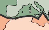
The Atlas Mountains are a mountain range in the Maghreb in North Africa. It separates the Sahara Desert from the Mediterranean Sea and the Atlantic Ocean; the name "Atlantic" is derived from the mountain range. It stretches around 2,500 km (1,600 mi) through Morocco, Algeria and Tunisia. The range's highest peak is Toubkal, which is in central Morocco, with an elevation of 4,167 metres (13,671 ft).[1] The Atlas mountains are primarily inhabited by Berber populations.[2] The terms for 'mountain' are Adrar and adras in some Berber languages, and these terms are believed to be cognates of the toponym Atlas. The mountains are also home to a number of animals and plants which are mostly found within Africa but some of which can be found in Europe. Many of these species are endangered and a few are already extinct. The weather is cooling but has sunny summers, and the average temperature there is 25°C.[3]
| Atlas Mountains | |
|---|---|
 Mount Toubkal in Toubkal National Park within the High Atlas, Morocco | |
| Highest point | |
| Peak | Toubkal, Morocco |
| Elevation | 4,167 m (13,671 ft) |
| Coordinates | 31°03′43″N 07°54′58″W |
| Geography | |
 Location of the Atlas Mountains (red) across North Africa
| |
| Country | Morocco, Algeria and Tunisia |
| Region | Maghreb |
| Geology | |
| Age of rock | Precambrian |
Geology

The basement rock of most of Africa was formed during the Precambrian supereon and is much older than the Atlas Mountains lying on the continent. The Atlas was formed during three subsequent phases of Earth's geology.
The first tectonic deformation phase involves only the Anti-Atlas, which was formed in the Paleozoic Era (~300 million years ago) as the result of continental collisions. North America, Europe and Africa were connected millions of years ago.
The Anti-Atlas Mountains are believed to have originally been formed as part of Alleghenian orogeny. These mountains were formed when Africa and America collided and were once a chain rivaling today's Himalayas. Today, the remains of this chain can be seen in the Fall Line region in the Eastern United States. Some remnants can also be found in the later formed Appalachians in North America.
A second phase took place during the Mesozoic Era (before ~66 My). It consisted of a widespread extension of the Earth's crust that rifted and separated the continents mentioned above. This extension was responsible for the formation of many thick intracontinental sedimentary basins including the present Atlas. Most of the rocks forming the surface of the present High Atlas were deposited under the ocean at that time.
Finally, in the Paleogene and Neogene Periods (~66 million to ~1.8 million years ago), the mountain chains that today constitute the Atlas were uplifted, as the land masses of Europe and Africa collided at the southern end of the Iberian Peninsula. Such convergent tectonic boundaries occur where two plates slide towards each other forming a subduction zone (if one plate moves underneath the other), and/or a continental collision (when the two plates contain continental crust). In the case of the Africa-Europe collision, it is clear that tectonic convergence is partially responsible for the formation of the High Atlas, as well as for the closure of the Strait of Gibraltar and the formation of the Alps and the Pyrenees. However, there is a lack of evidence for the nature of the subduction in the Atlas region, or for the thickening of the Earth's crust generally associated with continental collisions. In fact, one of the most striking features of the Atlas to geologists is the relative small amount of crustal thickening and tectonic shortening despite the important altitude of the mountain range. Recent studies suggest that deep processes rooted in the Earth's mantle may have contributed to the uplift of the High and Middle Atlas.[4][5]

Natural resources
The Atlas are rich in natural resources. There are deposits of iron ore, lead ore, copper, silver, mercury, rock salt, phosphate, marble, anthracite coal and natural gas among other resources.[citation needed]
Subranges
The range can be divided into four general regions:
- Anti-Atlas, High Atlas and Middle Atlas (Morocco)
- Tell Atlas (Morocco, Algeria, Tunisia)
- Aurès Mountains (Algeria, Tunisia)
- Saharan Atlas (Algeria)
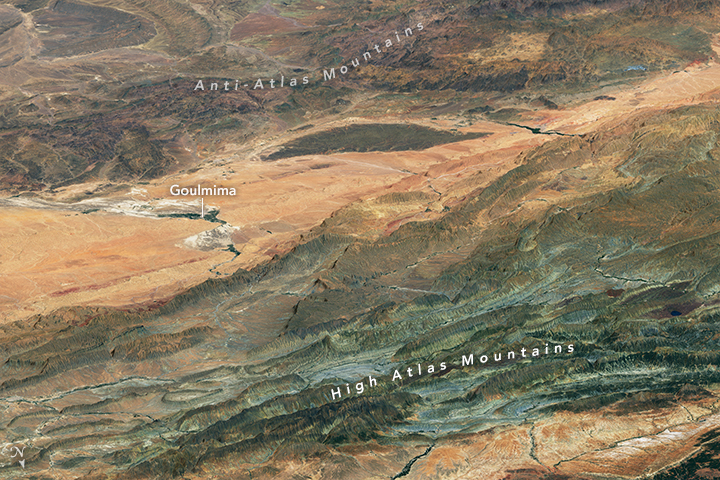
Anti-Atlas
The Anti-Atlas extends from the Atlantic Ocean in , the southwest of Morocco toward the northeast to the heights of Ouarzazate and further east to the city of Tafilalt (altogether a distance of approximately 500 kilometres or 300 miles). In the south it borders the Sahara. The easternmost point of the anti-Atlas is the Jbel Saghro range and its northern boundary is flanked by sections of the High Atlas range. It includes the Djebel Siroua, a massif of volcanic origin with the highest summit of the range at 3,304 m. The Jebel Bani is a much lower range running along the southern side of the Anti Atlas.[6]
High Atlas

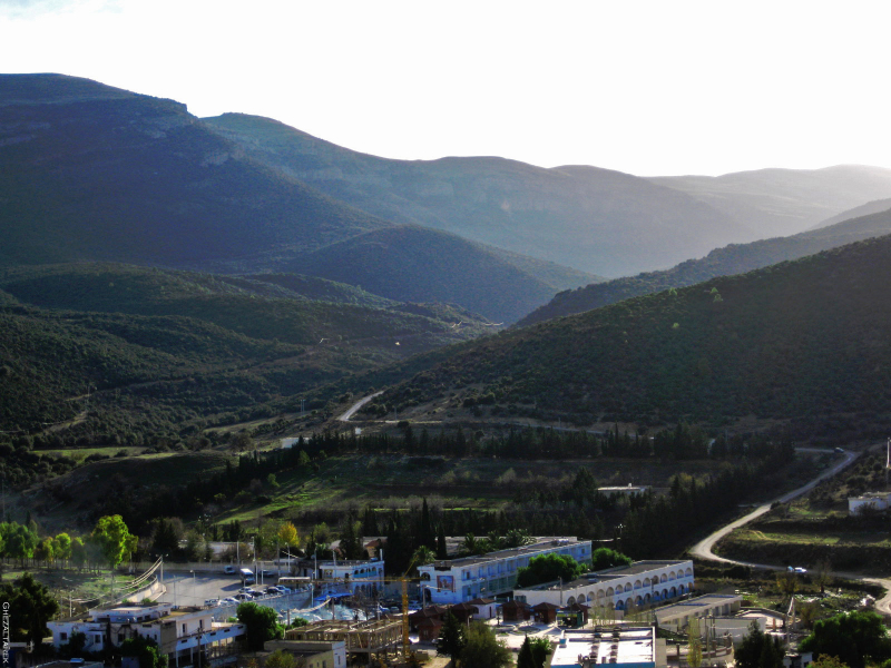
The High Atlas in central Morocco rises in the west at the Atlantic coast and stretches in an eastern direction to the Moroccan-Algerian border. It has several peaks over 4,000 m (13,000 ft), including the highest summit in North Africa, Toubkal (4,167 m or 13,671 ft), and further east Ighil m'Goun (4,071 m or 13,356 ft), the second major summit of the range. At the Atlantic and to the southwest, the range drops abruptly and makes a transition to the coast and the Anti-Atlas range. To the north, in the direction of Marrakesh, the range descends less abruptly. On the heights of Ouarzazate the massif is cut through by the Draa Valley which opens southward. It is mainly inhabited by Berber people, who live in small villages and cultivate the high plains of the Ourika Valley. Near Barrage Cavagnac[7] there is a hydroelectric dam that has created the artificial lake Lalla Takerkoust. The lake serves also as a source for fish for the local fishermen.
The largest villages and towns of the area are Ouarzazate, Tahannaout, Amizmiz, Imlil, Tin Mal and Ijoukak.


Middle Atlas
The Middle Atlas is completely in Morocco and is the northernmost of its three main Atlas ranges. The range lies north of the High Atlas, separated by the Moulouya and Oum Er-Rbia rivers, and south of the Rif mountains, separated by the Sebou River. To the west are the main coastal plains of Morocco with many of the major cities and, to the east, the high barren plateau that lies between the Saharan and Tell Atlas. The high point of the range is the jbel Bou Naceur (3340 m). The Middle Atlas experiences more rain than the ranges to the south, making it an important water catchment for the coastal plains and important for biodiversity. It is home to the majority of the world's population of Barbary macaque.

Saharan Atlas
The Saharan Atlas of Algeria runs east of the High Atlas, crossing Algeria from the Moroccan border and into Tunisia. The Aures Mountains are often presented as being the easternmost part of the Saharan Atlas. Though not as high as the High Atlas, they reach similar altitudes as the Tell Atlas range that runs to the north of them and closer to the coast. The highest peak in the range, outside of the Aures Mountains, is the 2,236 m (7,336 ft) high Djebel Aissa. They mark the northern edge of the Sahara Desert. The mountains see some rainfall and are better suited to agriculture than the plateau region to the north. Today, most of the population of the region are Berbers (Imazighen).[citation needed]
Tell Atlas

The Tell Atlas is a mountain chain over 1,500 kilometres (900 mi) in length, belonging to the Atlas mountain ranges and stretching from Eastern Morocco to Tunisia, and through Algeria. It parallels the Mediterranean coast and joins with the Saharan Atlas in Eastern Algeria and Tunisia. The highest summit of the Tell Atlas is the 2,308 m (7,572 ft) Lalla Khadidja in the Djurdjura range of Kabylia. The western end of the Tell Atlas merges with the Middle Atlas range in Morocco. The area immediately to the south of the Tell Atlas is the high plateau of the Hautes Plaines, with lakes in the wet season and salt flats in the dry. The eastern half of the Tell Atlas has the most humid climate of North Africa, with annual precipitation reaching well above 1,000 mm (39 in), and sometimes over 1,500 mm (59 in) like in the Collo Peninsula or near Ain Draham. An important amount of snow falls on the summits in winter.
Aurès
The Aurès Mountains are the easternmost portion of the Atlas mountain range. It covers parts of Algeria and Tunisia. The Aurès natural region is named after the range.[8]
Flora and fauna
This section needs expansion. You can help by adding to it. (April 2018) |
![A male Barbary lion photographed in Algeria by Alfred Edward Pease in 1893.[9]](http://upload.wikimedia.org/wikipedia/commons/4/43/Barbary_lion.jpg)

Flora in the mountains include the Atlas cedar,[10] evergreen oak and many semi-evergreen oaks such as the Algerian oak.
Examples of animals that live in the area include the Barbary macaque,[11] Barbary leopard,[12] Barbary stag, Barbary sheep, Atlas Mountain badger, Cuvier's gazelle, northern bald ibis, Algerian nuthatch, dipper, and Atlas mountain viper.
Many animals used to inhabit the Atlas mountains such as the Atlas bear,[13] North African elephant, North African aurochs, bubal hartebeest and Atlas wild ass,[14] but these subspecies are all extinct. Barbary lions[9] are currently extinct in the wild, but descendants exist in captivity.[15][16][17]
See also
- Atlas (mythology)
- Capsian culture
- Nafusa Mountains
- Teffedest Mountains
- Djurdjura Mountains
References and notes
- "Atlas Mountains – Students | Britannica Kids | Homework Help". kids.britannica.com. Retrieved 2017-07-07.
- "Atlas Mountains: Facts and Location | Study.com". Study.com. Retrieved 2017-07-07.
- "Atlas Mountains, Morocco - Live Weather Update - Holiday Weather".
- UAB.es[permanent dead link] Potential field modelling of the Atlas lithosphere
- UAB.es[permanent dead link] Crustal structure under the central High Atlas Mountains (Morocco) from geological and gravity data, P. Ayarza, et al., 2005, Tectonophysics, 400, 67–84
- "du Djebel Sarho aux dunes de Merzouga". vchery.free.fr. Retrieved 2021-01-19.
- French: L'INGÉNIEUR CAVAGNAC, un nom bien connu des Anciens de Marrakech...
- "Algeria – Ethnic Groups and Languages".
- Pease, A. E. (1913). "The Distribution of Lions". The Book of the Lion. London: John Murray. pp. 109−147.
- Gaussen, H. (1964). Genre Cedrus. Les Formes Actuelles. Trav. Lab. For. Toulouse T2 V1 11: 295–320
- Van Lavieren, E. (2012). The Barbary Macaque (Macaca sylvanus); A unique endangered primate species struggling to survive. Revista Eubacteria, (30): 1–4.
- Emmanuel, John (September 1982). "A Survey of Population and Habitat of the Barbary Macaqu Macaca Sylvanus L. In North Morocco". Biological Conservation. 24 (1): 45–66. doi:10.1016/0006-3207(82)90046-5.
- Johnston, H. H. (1899). Bryden, H. A. (ed.). Great and small game of Africa. London: Rowland Ward Ltd. pp. 544–608.
- Des Roses Moehlman, Patricia (2002). Equids: Zebras, Asses, and Horses: Status Survey and Conservation Action plan. Cambridge: IUCN. p. 2. ISBN 9782831706474.
- Yamaguchi, N.; Haddane, B. (2002). "The North African Barbary Lion and the Atlas Lion Project". International Zoo News. 49 (8): 465–481.
- Burger, J.; Hemmer, H. (2006). "Urgent call for further breeding of the relic zoo population of the critically endangered Barbary lion (Panthera leo leo Linnaeus 1758)" (PDF). European Journal of Wildlife Research. 52 (1): 54–58. doi:10.1007/s10344-005-0009-z. S2CID 30407194. Archived from the original (PDF) on 2007-07-03. Retrieved 2007-04-04.
- Black, S.; Yamaguchi, N.; Harland, A. & Groombridge, J. (2010). "Maintaining the genetic health of putative Barbary lions in captivity: an analysis of Moroccan Royal Lions" (PDF). European Journal of Wildlife Research. 56 (1): 21–31. doi:10.1007/s10344-009-0280-5. S2CID 44941372. Archived (PDF) from the original on 2017-08-08.
External links
Earth's primary regions and subregions | |
|---|---|
| Africa | |
| North America |
|
| South America |
|
| Asia |
|
| Europe |
|
| Oceania |
|
| Polar |
|
| Oceans |
|
| |
Authority control | |
|---|---|
| General | |
| National libraries | |
| Other | |
На других языках
[de] Atlas (Gebirge)
Der Atlas (arabisch جبال الأطلس, DMG Ǧibāl al-Aṭlas, berberisch ⵉⴷⵓⵔⴰⵔ ⵏ ⵡⴰⵟⵍⴰⵚ .mw-parser-output .Latn{font-family:"Akzidenz Grotesk","Arial","Avant Garde Gothic","Calibri","Futura","Geneva","Gill Sans","Helvetica","Lucida Grande","Lucida Sans Unicode","Lucida Grande","Stone Sans","Tahoma","Trebuchet","Univers","Verdana"}Idurar n Waṭlaṣ) ist ein Hochgebirge im Nordwesten Afrikas, das sich in einer Länge von etwa 2300 Kilometer über die Staaten Marokko, Algerien und Tunesien erstreckt. Der höchste Gipfel ist mit 4167 Metern der Toubkal im Süden Marokkos. Der Atlas bildet eine markante Scheidelinie zwischen dem relativ feuchten Klima im äußersten Norden des Maghreb und der extrem trockenen Sahara. Er ist Teil des Alpidischen Gebirgssystems.- [en] Atlas Mountains
[es] Cordillera del Atlas
La cordillera del Atlas, macizo del Atlas o simplemente Atlas es un sistema montañoso que recorre, a lo largo de 2400 km, el noroeste de África. La cordillera recorre Túnez, Argelia y Marruecos, siendo su pico más alto el Toubkal, con 4167 m, al sudoeste de Marruecos.[fr] Atlas (massif)
L'Atlas (en arabe : جبال الأطلس, jibāl al-aṭlas) est un massif montagneux de l'Afrique du Nord, culminant à 4 167 mètres d'altitude au djebel Toubkal, au Maroc. Il s'étend sur trois pays : le Maroc, l'Algérie et la Tunisie.[it] Atlante (catena montuosa)
La catena montuosa dell'Atlante (in berbero: ⵉⴷⵓⵔⴰⵔ ⵏ ⵓⴰⵟⵍⴰⵙ, Idurar n Waṭlas; in arabo: جبال الأطلس, Jibāl Al-Aṭlas) è una catena montuosa dell'Africa nord-occidentale, composta da diverse dorsali montuose, che si estende per circa 2.500 km tra Marocco, Algeria e Tunisia.[ru] Атлас (горы)
А́тлас[2][3][4], Атласские горы (араб. جبال الأطلس jibāl al-aṭlas, бербер. ⵉⴷⵔⴰⵔⵏ ⵏ ⵡⴰⵟⵍⴰⵚ idraren n waṭlaṣ, фр. Massif de Atlas; название происходит от греч. Ἄτλας — имени греческого титана Атласа) — большая горная система на северо-западе Африки, тянущаяся от атлантического побережья Марокко через Алжир до берегов Туниса; позднее под этим названием стала объединяться вся горная система от мыса Котей (современный мыс Спартель близ Танжера) до Сиртов (Малый Сирт). Длина хребтов — 2092 км. Наивысшая точка — гора Тубкаль (4167 м), находится на юго-западе.Другой контент может иметь иную лицензию. Перед использованием материалов сайта WikiSort.org внимательно изучите правила лицензирования конкретных элементов наполнения сайта.
WikiSort.org - проект по пересортировке и дополнению контента Википедии