geo.wikisort.org - Mountains
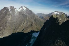
The Ruwenzori, also spelled Rwenzori and Rwenjura, are a range of mountains in eastern equatorial Africa, located on the border between Uganda and the Democratic Republic of the Congo. The highest peak of the Ruwenzori reaches 5,109 metres (16,762 ft), and the range's upper regions are permanently snow-capped and glaciated. Rivers fed by mountain streams form one of the sources of the Nile.[1] Because of this, European explorers linked the Ruwenzori with the legendary Mountains of the Moon, claimed by the Greek scholar Ptolemy as the source of the Nile. Virunga National Park in eastern DR Congo and Rwenzori Mountains National Park in southwestern Uganda are located within the range.
| Ruwenzori | |
|---|---|
 | |
| Highest point | |
| Peak | Mount Stanley |
| Elevation | 5,109 m (16,762 ft) |
| Coordinates | 00°23′09″N 29°52′18″E |
| Dimensions | |
| Length | 120 km (75 mi) |
| Geography | |
 Ruwenzori | |
| Country | Uganda, Democratic Republic of the Congo |
Geology


The mountains formed about three million years ago in the late Pliocene epoch and are the result of an uplifted block of crystalline rocks including gneiss, amphibolite, granite and quartzite.[2]
The Rwenzori mountains are the highest non-volcanic, non-orogenic mountains in the world.[3]
This uplift divided the paleolake Obweruka and created three of the present-day African Great Lakes: Lake Albert, Lake Edward,[2] and Lake George.[4]
The range is about 120 kilometres (75 mi) long and 65 kilometres (40 mi) wide. It consists of six massifs separated by deep gorges: Mount Stanley (5,109 metres (16,762 ft)), Mount Speke (4,890 metres (16,040 ft)), Mount Baker (4,843 metres (15,889 ft)), Mount Emin (4,798 metres (15,741 ft)), Mount Gessi (4,715 metres (15,469 ft)) and Mount Luigi di Savoia (4,627 metres (15,180 ft)).[5] Mount Stanley has several subsidiary summits, with Margherita Peak being the highest point.
Human history

The mountains are occasionally identified with the legendary "Mountains of the Moon", described in antiquity as the source of the Nile River.[1] Modern European explorers observed the range beginning in the late nineteenth century, with Samuel Baker reporting what he called the "Blue Mountains" looming in the distance in 1864, and Henry M. Stanley visiting the range in 1875 and 1888, when he recorded the name as "Ruwenzori".[6]
In 1906, the Duke of Abruzzi mounted an expedition to the Ruwenzori, the account of which was subsequently published by Filippo De Filippi. The expedition scaled the highest peaks of the range, several of which were named by the duke, while Mount Luigi di Savoia was named in his honour.[6] Accompanying the duke was photographer Vittorio Sella, who had previously visited the mountains. His photographs of the glaciers and moraines of the Ruwenzori demonstrated that the glaciers were already in retreat.[6][7] Sella's photographic work is conserved at the Museo Nazionale della Montagna in Turin and at the Istituto di Fotografia Alpina Vittorio Sella in Biella, both in Italy. The Makerere University, Uganda, also has a selection of his images.[8]
The first traverse of the six massifs of the Ruwenzori was done in 1975, starting on 27 January and ending on 13 February. The traverse was done by Polish climbers Janusz Chalecki, Stanisław Cholewa and Leszek Czarnecki, with Mirosław Kuraś accompanying them on the last half of the traverse.[9]
Since Uganda's independence from the British Empire, the Rwenzori Mountains have repeatedly become sanctuaries to rebel groups. The secessionist Rwenzururu movement fought an insurgency in the mountains in the 1960s.[10] In course of the Ugandan Bush War, the Rwenzururu movement reemerged and continued its struggle until signing a peace deal with Ugandan President Milton Obote's government.[11] In the Bush War's later stages, the National Resistance Army (NRA) rebel force operated in the mountains. After the NRA seized power in Uganda in 1986,[12] another civil war broke out. This time, the Rwenzori Mountains hosted the bases of the National Army for the Liberation of Uganda (NALU)[13] and the "Partie de Liberation Congolaise" (PLC), an anti-Mobutu rebel group.[14] In the early 1990s, a Congolese rebel group known as the National Council of Resistance for Democracy (Conseil National de Résistance pour la Démocratie, CNRD) led by André Kisase Ngandu began to wage an insurgency against Mobutu from the Rwenzori Mountains.[15]
Militias aligned with the old Rwenzururu movement's ideology occupied the Rwenzori Mountains from 1997 to June 2001.[16] In 2020, after being defeated across the border by the Armed Forces of the Democratic Republic of the Congo, some elements of the Allied Democratic Forces moved into the Rwenzori Mountains.[17]
Natural history
Flora

The Ruwenzori are known for their vegetation, ranging from tropical rainforest through alpine meadows to snow. The range supports its own species and varieties of giant groundsel and giant lobelia and even has a 6 metres (20 ft) tall heather covered in moss that lives on one of its peaks. Most of the range is now a World Heritage Site and is covered jointly by Rwenzori Mountains National Park in southwestern Uganda and the Virunga National Park in the eastern Congo.[5]
There is no water shortage in the Ruwenzori; yet, several members of the afro-alpine family resemble species that normally thrive in desert climates. The reason lies in their similar water economy. Water is not always readily available to the afroalpine plants when they need it. In addition, nightly frosts affect the sap transport in the plants and the intake of water by its roots. As the day begins, the air temperature and radiation level rise rapidly, putting strenuous demands on the exposed parts of the plants as they try to meet the transpiration demands of the leaves and maintain a proper water balance. To counter the effects of freezing, the afro-alpine plants have developed the insulation systems that give them such a striking appearance. These adaptations become more prominent as the elevation increases.[8]
There are five overlapping vegetation zones in the Ruwenzori: the evergreen forest zone (up to 2,800 metres (9,200 ft)); the bamboo zone (2,800 to 3,300 metres (9,200 to 10,800 ft)); the heather zone (3,000 to 3,800 metres (9,800 to 12,500 ft)); the alpine zone (3,500 to 4,500 metres (11,500 to 14,800 ft)); and, the nival zone (4,400 to 5,000 metres (14,400 to 16,400 ft)). At higher elevations, some plants reach an unusually large size, such as lobelia and groundsels. The vegetation in the Ruwenzori is unique to equatorial alpine Africa.[18]
| Meters Order | 1500 | 2000 | 2500 | 3000 | 3200 | 3400 | 3600 | 3800 | 4000 | 4200 | 4400 | 4600 | 4800 | 5000 | 5100 |
|---|---|---|---|---|---|---|---|---|---|---|---|---|---|---|---|
| Lamiales | Mimulopsis elliotii Mimulopsis arborescens | ||||||||||||||
| Rosales | Prunus africana | Hagenia abyssinica | |||||||||||||
| Alchemilla subnivalis Alchemilla stuhlmanii Alchemilla triphylla Alchemilla johnstonii | |||||||||||||||
| Alchemilla argyrophylla | |||||||||||||||
| Fabales | Albizia gummifera | ||||||||||||||
| Cornales | Alangium chinense | ||||||||||||||
| Malpighiales | Casearia battiscombei Croton macrostachyus Neoboutonia macrocalyx Symphonia globulifera | Hypericum sp | |||||||||||||
| Hypericum revolutum Hypericum bequaertii | |||||||||||||||
| Asparagales | Scadoxus cyrtanthiflorus | ||||||||||||||
| Disa stairsii | |||||||||||||||
| Asterales | Dendrosenecio erici-rosenii | ||||||||||||||
| Dendrosenecio adnivalis Helichrysum sp. Lobelia bequaertii Lobelia wollastonii | Helichchrysum guilelmii | ||||||||||||||
| Helichchrysum stuhlmanii | |||||||||||||||
| Senecio transmarinus Senecio mattirolii | |||||||||||||||
| Apiales | Peucedanum kerstenii | ||||||||||||||
| Myrtales | Syzygium guineense | ||||||||||||||
| Sapindales | Allophylus abyssinicus | ||||||||||||||
| Gentianales | Tabernaemontana sp. | Galium ruwenzoriense | |||||||||||||
| Ericales | Pouteria adolfi-friedericii | Erica arborea Erica trimera | |||||||||||||
| Erica silvatica Erica johnstonii | |||||||||||||||
| Brassicales | Subularia monticola | ||||||||||||||
| Primulales | Rapanea rhododendroides | ||||||||||||||
| Ranunculales | Ranunculus oreophytus Arabis alpina | ||||||||||||||
| Santalales | Strombosia scheffleri | ||||||||||||||
| Poales | Yushania alpina | Carex runssoroensis Festuca abyssinica | |||||||||||||
| Poa ruwenzoriensis | |||||||||||||||
| Lecanorales | Usnea | ||||||||||||||
| Order Meters | 1500 | 2000 | 2500 | 3000 | 3200 | 3400 | 3600 | 3800 | 4000 | 4200 | 4400 | 4600 | 4800 | 5000 | 5100 |
Glacial recession

An ongoing concern is the impact of climate change on the Ruwenzori's glaciers. In 1906, forty-three named glaciers were distributed over six mountains with a total area of 7.5 square kilometres (2.9 sq mi), about half the total glacier area in Africa. By 2005, less than half of these were still present, on only three mountains, with an area of about 1.5 square kilometres (0.58 sq mi). Recent scientific studies, such as those by Richard Taylor of University College London, have attributed this retreat to global climate change and have investigated the impact of this change on the mountain's vegetation and biodiversity.[21][22][23] In 2012 Klaus Thymann lead an expedition with the environmental charity Project Pressure creating comparative photographs to visually document the glacier recession, the findings were published in global media including The Guardian.[24] The alteration can be seen in comparative images. As the temperature rises and the glaciers recede, vegetation slowly creeps up the mountain.
See also
- 1966 Toro earthquake
Notes
- Scheffel, Richard L.; Wernet, Susan J., eds. (1980). Natural Wonders of the World. United States of America: Reader's Digest Association, Inc. p. 327. ISBN 0-89577-087-3.
- "Climate Change and the Aquatic Ecosystems of the Rwenzori Mountains". Makerere University and University College London. 15 September 2007. Retrieved 2 February 2014.
- "The Mountains of the Moon". 20 February 2021.
- Wayland, E. J. (July–December 1934). "Rifts, Rivers, Rains and Early Man in Uganda". Journal of the Royal Anthropological Institute. Royal Anthropological Institute of Great Britain and Ireland. 64: 333–352. doi:10.2307/2843813. JSTOR 2843813.
- "Rwenzori Mountains National Park". Rwenzori Abruzzi. 27 May 2006. Archived from the original on 5 March 2008. Retrieved 6 May 2008.
- "Abruzzi's Conquest of Lofty "Ruwenzori"". The New York Times. 15 November 1908. Retrieved 20 October 2022.
- "Vittorio Sella". Rwenzori Abruzzi Centenary Celebrations. 2006. Archived from the original on 8 May 2008. Retrieved 9 August 2008.
- Flowers of the Moon, Afroalpine vegetation of the Rwenzori Mountains Archived 24 September 2015 at the Wayback Machine, Schutyser S., 2007, 5 Continents Editions, ISBN 978-88-7439-423-4.
- Wielka Grań Ruwenzori 1975, Wojtera T., Taternik iss 3. 1976.
- Rothchild, Donald S. (1997). Managing ethnic conflict in Africa: pressures and incentives for cooperation. Brookings Institution Press. p. 90. ISBN 978-0-8157-7593-5.
- Forrest, Joshua (2004). Subnationalism in Africa: ethnicity, alliances, and politics. Lynne Rienner Publishers. ISBN 978-1-58826-227-1. Retrieved 6 June 2009.
- "UNLA commander John Ogole's account of Luweero war". Daily Monitor. 22 September 2018. Retrieved 3 May 2021.
- Day 2011, p. 447.
- Prunier 2009, p. 83.
- Stearns 2012, Chapter 6: Mzee.
- "Rwenzori Mountains National Park, Uganda". United Nations Environment Programme. March 2003. Archived from the original on 10 May 2008. Retrieved 3 June 2008.
- Dino Mahtani; Nelleke van de Walle; Piers Pigou; Meron Elias (18 March 2021). "Understanding the New U.S. Terrorism Designations in Africa". International Crisis Group. Retrieved 27 March 2021.
- Linder, H. Peter; Gehrke, Berit (2 March 2006). "Common plants of the Rwenzori, particularly the upper zones" (PDF). Institute for Systematic Botany, University of Zurich. Archived from the original (PDF) on 30 May 2008. Retrieved 6 June 2017.
- "RWENZORI MOUNTAINS NATIONAL PARK, UGANDA". Protected Areas and World Heritage. United Nations Environment Programme. March 1994. Archived from the original on 25 March 2008. Retrieved 8 May 2008.
- "Forest Resources of Tropical Africa". Tropical Forest Resources Assessment Project (reprint ed.). Food and Agriculture Organization of the United Nations. 1984. UN 32/6.1301–78–04. Retrieved 12 May 2008.
- Taylor, R. G.; Mileham, L.; Tindimugaya, C.; Majugu, A.; Muwanga, A.; Nakileza, B. (2006). "Recent glacial recession in the Rwenzori Mountains of East Africa due to rising air temperature" (PDF). Geophysical Research Letters. 33 (10): L10402. Bibcode:2006GeoRL..3310402T. doi:10.1029/2006GL025962. S2CID 1081063.
- Tom Knudson, In the Mountains of the Moon, A Trek to Africa’s Last Glaciers, Yale Environment 360 Report, 4 February 2010
- [Rwenzori Glaciers (East Africa)], Tropical Glaciology Group, Innsbruck University
- "The race to map Africa's forgotten glaciers – in pictures". The Guardian. 2 June 2012. ISSN 0261-3077. Retrieved 2 May 2022.
References
- Day, Christopher R. (July 2011). "The Fates of Rebels: Insurgencies in Uganda". Comparative Politics. 43 (4): 439–458. doi:10.5129/001041511796301623. JSTOR 23040638.
- Glaciers of the Middle East and Africa, Williams, Richard S., Jr. (editor) In: U. S. Geological Survey Professional Paper, 1991, pp.G1-G70
- Guide to the Ruwenzori, Osmaston,H.A., Pasteur,D. 1972, Mountain Club of Uganda. 200 p.
- Recession of Equatorial Glaciers. A Photo Documentation, Hastenrath, S., 2008, Sundog Publishing, Madison, WI, ISBN 978-0-9729033-3-2, 144 pp.
- Tropical Glaciers, Kaser, G., Osmaston, H.A. 2002, Cambridge University Press, UK. 207 p.
- Ruwenzori, De Filippi, F. 1909. Constable, London. 408 p.
- Greenpeace article "The Death of the Ice Giants"
- BBC Article "Fabled ice field set to vanish"
- Dr Taylor's Homepage, with information about the impact of climate change on Ruwenzori.
- Kaser et al. 2006, in International Book of Climatology 24: 329–339 (2004)
- Prunier, Gérard (2009). Africa's World War : Congo, the Rwandan Genocide, and the Making of a Continental Catastrophe: Congo, the Rwandan Genocide, and the Making of a Continental Catastrophe. Oxford: Oxford University Press. ISBN 978-0-19-970583-2.
- Stearns, Jason (2012). Dancing in the Glory of Monsters: The Collapse of the Congo and the Great War of Africa. New York City: PublicAffairs. ISBN 978-1610391597.
External links
- World Wildlife Fund, ed. (2001). "Ruwenzoris". WildWorld Ecoregion Profile. National Geographic Society. Archived from the original on 8 March 2010.
- UWM.edu: 1937 aerial photographs of Rwenzori Mountains – University of Wisconsin-Milwaukee Libraries Digital Collections.
- Beach, Chandler B., ed. (1914). . . Chicago: F. E. Compton and Co.
| Authority control: National libraries |
|---|
На других языках
[de] Ruwenzori-Gebirge
Das Ruwenzori-Gebirge (im Englischen meist Rwenzori geschrieben) ist mit bis zu 5109 m das dritthöchste Gebirge Afrikas. Es liegt in Ostafrika auf der Grenze zwischen der Demokratischen Republik Kongo und Uganda und gehört zu den drei einzigen Gebirgen Afrikas, die Vergletscherungen aufweisen. Wegen seiner hohen ökologischen Bedeutung ist es Teil des UNESCO-Weltnaturerbes.- [en] Rwenzori Mountains
[es] Montañas Rwenzori
La cadena Ruwenzori, originalmente conocida como Rwenjura y oficialmente Rwenzori (desde que en 1980 se renombró para parecerse más a este nombre), es una pequeña cordillera de África situada en la frontera entre Uganda y la República Democrática del Congo, que llega hasta los 5109 m en el monte Stanley, lo que le hace ser la tercera cumbre de África después del Kilimanjaro y el monte Kenia. Es unas de las pocas cadenas montañosas de África con glaciares, con el Kilimanjaro y el monte Kenia. Los glaciares, sin embargo, amenazan con desaparecer por el calentamiento global.[1][fr] Rwenzori
Le Rwenzori, chaîne du Rwenzori ou monts Rwenzori, aussi orthographié jusqu'en 1980 Ruwenzori, parfois identifiées comme étant les légendaires montagnes de la Lune de l'Égypte antique et plus tard des Grecs anciens, est une petite chaîne de montagnes de l'Afrique centrale, située sur la frontière entre l'Ouganda et la République démocratique du Congo, culminant à 5 109 mètres d'altitude au pic Marguerite (mont Stanley), ce qui en fait le troisième sommet d'Afrique après le Kilimandjaro et le mont Kenya. C'est une des rares montagnes englacées d'Afrique avec le Kilimandjaro ou encore le mont Kenya. Les glaciers pourraient cependant disparaître en raison du réchauffement climatique[1].[it] Ruwenzori
Il Ruwenzori (geograficamente Montagne del Ruwenzori; in italiano chiamato anche Ruvenzori), in lingua locale Rwenzori oppure Rwenjura,[1] è un gruppo montuoso dell'Africa centrale, posizionato al confine tra Uganda e Repubblica Democratica del Congo.[ru] Рувензори
Рувензо́ри (суахили Ruwenzori), или Руэнзо́ри (Rwenzori) — горный массив в Восточной и Центральной Африке, на границе Уганды и Демократической Республики Конго. Возможно, этот горный хребет и есть те самые Лунные горы, упоминаемые античными географами как исток Нила.[2]. Название «Рувензори» в переводе означает «творец дождя» или «повелитель облаков»[3].Другой контент может иметь иную лицензию. Перед использованием материалов сайта WikiSort.org внимательно изучите правила лицензирования конкретных элементов наполнения сайта.
WikiSort.org - проект по пересортировке и дополнению контента Википедии