geo.wikisort.org - Mountains
The Marrah Mountains or Marra Mountains (Fur, Fugo Marra; Arabic: جبل مرة, Jebel Marra are a range of volcanic peaks in a massif that rises up to 3,042 metres (9,980 ft). They are the highest mountains in Sudan.
| Marrah Mountains | |
|---|---|
| Jebel Marra | |
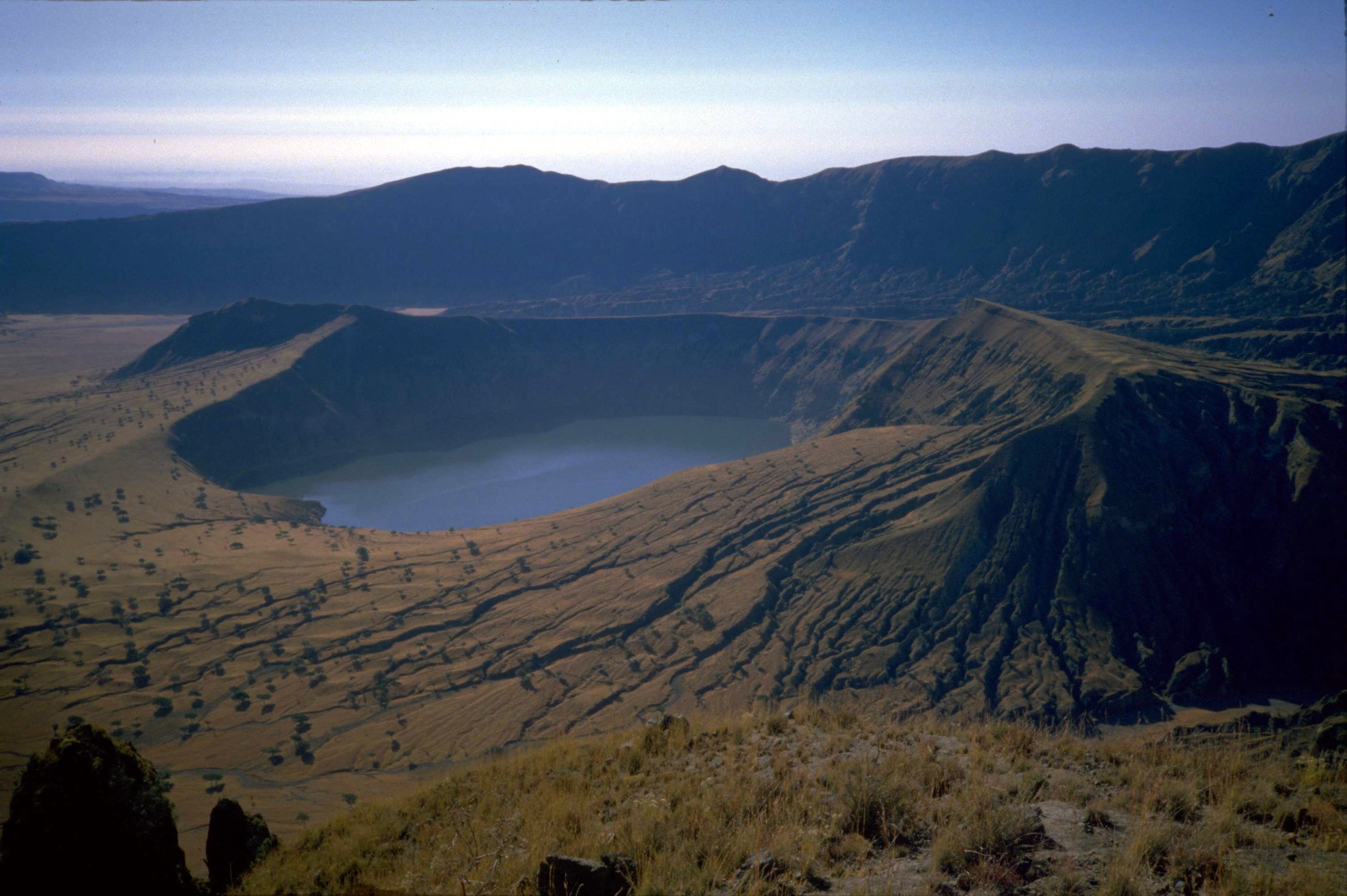 Inner and outer crater, Deriba Crater | |
| Highest point | |
| Peak | Deriba crater |
| Elevation | 3,042 m (9,980 ft) |
| Coordinates | 12°57′00″N 24°16′12″E |
| Geography | |
 Location in Sudan | |
| Country | Sudan |
| Region | Darfur |
| Geology | |
| Type of rock | Volcanic field |
| Last eruption | 2000 BC |
Geography

The mountains are located in the center of the Darfur region of Sudan on the border of the states of South Darfur and Central Darfur, with a smaller part of the range in the state of North Darfur. The highest point is Deriba Caldera. The upper reaches of the massif is a small area of temperate climate with high rainfall and permanent springs of water amidst the dry savanna and scrub of the Sahel below.[1]
Apart from the Aïr Mountains in Niger which are on the border of the Sahara proper, the Marrah Mountains are the only major mountain range in the otherwise flat Sahel, rising up to 2,600 metres (8,500 ft) above the plain, but are relatively unknown owing to lack of development and political conflict in the region.
The last eruption occurred around 1500 BC. The centre of activity was Deriba Caldera, and involved caldera collapse following the eruption of pumice and pyroclastic flows which travelled over 30 kilometres (19 mi) from the volcano.[2]
The vegetation was described by Gerald Wickens.[3]
History
In course of the War in Darfur, the Marrah Mountains fell under control of the rebel Sudan Liberation Movement/Army faction loyal to Abdul Wahid al Nur. The mountains remained one of the group's most important strongholds, housing several of its bases, as of 2021.[4]
Footnotes
- de Waal, Alex, Famine that Kills: Darfur, Sudan, Oxford University Press (Revised edition), 2005, ISBN 0-19-518163-8, p. 36
- "Jebel Marra: Eruptive History". Global Volcanism Program. Smithsonian Institution.
- Wickens, Gerald (1976). Flora of Jebel Marra (Sudan Republic) and its Geographical Affinities. Royal Botanic Gardens, Kew. ISBN 9780112411000.
- Philip Kleinfeld; Mohammed Amin (21 April 2021). "In Darfur's rebel-held mountains, the war is far from over". The New Humanitarian. Retrieved 23 April 2021.
References
- "Jebel Marra". Global Volcanism Program. Smithsonian Institution.
This Sudan location article is a stub. You can help Wikipedia by expanding it. |
На других языках
[de] Marra
Der Marra (arabisch جبل مرة Dschabal Marra; auch Jebel Marra) ist ein 3042 m[1] hoher Vulkan auf dem Marra-Plateau im Westen des Sudan. Er ist der höchste Berg des Landes.- [en] Marrah Mountains
[es] Montañas Marrah
Las montañas Marrah o montañas Marra (Fur, Fugo Marra; árabe: جبل مرة, Jebel Marra (árabe sudanés - "montañas de la mujer" debido a la silueta de una mujer reclinada cuando se ve desde el sureste, son una cordillera de picos volcánicos en un macizo que se eleva hasta los 3.042 metros. Son las montañas más altas de Sudán.[fr] Djebel Marra
Le djebel Marra (arabe : جبل مرة) est un stratovolcan situé au Darfour, dans l'Ouest du Soudan, culminant à 3 042 m d'altitude. Depuis l'indépendance du Soudan du Sud, il remplace le mont Kinyeti comme point culminant du pays.[it] Jebel Marra
Il Jebel Marra ( in arabo: جبل مرة , Jabal Marra "montagna amara", o "cattiva") è un stratovulcano situato nel Darfur, nell'ovest del Sudan, alto 3042 m.[ru] Марра
Ма́рра[2] — потухший вулкан на плато Дарфур на западе Судана, наивысшая гора страны.Другой контент может иметь иную лицензию. Перед использованием материалов сайта WikiSort.org внимательно изучите правила лицензирования конкретных элементов наполнения сайта.
WikiSort.org - проект по пересортировке и дополнению контента Википедии