geo.wikisort.org - Mountains
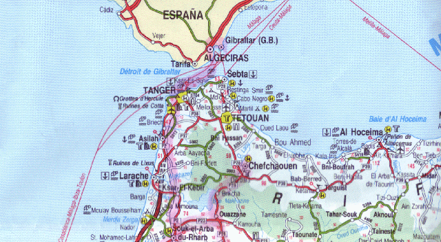
The Rif or Riff (Tarifit: ⴰⵔⵔⵉⴼ, ⴰⵔⵉⴼ, romanized: Arrif, Arif, Arabic: الريف), also called Rif Mountains, is a geographic region in northern Morocco. This mountainous and fertile area is bordered by Cape Spartel and Tangier to the west, by Berkane and the Moulouya River to the east, by the Mediterranean to the north, and by the Ouergha River to the south. The Rif mountains are separated into the eastern Rif mountains (Nador, Driouch, Al Hoceima) and western Rif mountains (Tangier, Tetouan, Chefchaouen, Taounate).[1]


| Rif | |
|---|---|
 A view of the Rif mountains around Chefchaouen | |
| Highest point | |
| Peak | Jbel Tidirhine |
| Elevation | 2,455 m (8,054 ft) |
| Naming | |
| Native name |
|
| Geography | |
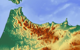 Map of the Rif in northern Morocco
| |
| Country | |
| Range coordinates | 35°N 4°W |
Geography
Geologically the Rif mountains belong to the Gibraltar Arc or Alborán Sea geological region. They are an extension of the Baetic System that includes the mountains of the southern Iberian Peninsula across the strait.[2] Thus the Rif mountains are not part of the Atlas Mountain System.
Major cities in the greater Rif region include Nador, Tangier, Tetouan, Al Hoceima (also called Villa), Imzouren, Driouch, Ben Taieb, Midar, Al Aaroui and a few (small) towns Segangan, Selwan, Ajdir, Targuist (Targist).
History
The Rif has been inhabited by Berbers since prehistoric times.[3] As early as the 11th century BCE, the Phoenicians began to establish trading posts, with approval of or partnership with the local Berbers and started interbreeding thus starting a Punic language on the Mediterranean and Atlantic coasts, and founded cities such as Tetouan, Rusadir (now Melilla) and, in the 5th century BCE, Tingi (now Tangier).
After the Third Punic War, the coast of North Africa came under the control of Rome, and the Rif became part of the Kingdom of Mauretania. When the latter was divided during the rule of Emperor Claudius, Tangier became the capital of Mauretania Tingitana.[4] In the 5th century CE the Roman rule came to an end. The region was reconquered and partly controlled by the Byzantine Empire in the 5th century.[5]
In 710, Salih I ibn Mansur founded the Emirate of Nekor in the Rif and Berbers started converting to Islam. By the 15th century, many Moors were exiled from Spain and most of them settled in Western Rif, bringing their culture, Andalusian music, and even establishing the city of Chefchaouen. Since then, the Rif has suffered numerous battles with Spain and Portugal. In 1415, Portugal invaded Ceuta, and in 1490 Spain conquered Melilla.[6][7]
The Hispano-Moroccan War broke out in 1859 in Tetouan, where Morocco was defeated.[8] The Spanish-Moroccan conflicts continued in the 20th century, under the leadership of Abd el-Krim, the Berber guerrilla leader who proclaimed the Republic of the Rif in 1921.[9] The Riffian Berbers won several victories over the Spanish in the Rif War of the 1920s before being eventually defeated.[10] The region was decolonised and restored to Morocco by Spain in April 1956, a month after the French protectorate part gained its independence from France.[11] Shortly after this, a revolt broke out in the north against the Moroccan king by Riffian insurgents in 1958, however it was easily suppressed.[12]
Economy
Farmers in the Rif produce most of Morocco's supply of cannabis. The region is economically underdeveloped.[13]
Environment


According to C. Michael Hogan, there are between five and eight separate subpopulations of the endangered primate Barbary macaque, Macaca sylvanus.[14] The Rif mountains are also home to the honey bee subspecies Apis mellifera major.
The Rif region receives more rainfall than any other region in Morocco, with some portions receiving upwards of 2,000 mm (78.74 in) of precipitation a year.[citation needed] The western and central portions are more rainy and are covered in forests of Atlas cedar, cork oak and holm oak, as well as the only remaining forests of Moroccan fir, a subspecies of the Spanish fir.[citation needed] The eastern slopes receive less rainfall, and there forests consist mainly of pines, particularly the Aleppo pine and the maritime pine, as well as tetraclinis.[citation needed]
Massive deforestation due to overgrazing, forest fires, and forest clearing for agriculture, particularly for the creation of cannabis plantations, has taken place since the 1950s. This deforestation has led to soil degradation due to the washing away of topsoil, which has aggravated the process.[citation needed]

See also
- Ghomaras
- Hirak Rif
- Jebala people
- Iznasen
- Nekor
- Tanger-Tetouan-Al Hoceima
- Oriental (Morocco)
- Riffian
Footnotes
- "Rif | mountains, Morocco | Britannica". www.britannica.com. Retrieved 2022-05-31.
- Davis, Dan. "Dissertation (Univ. of Texas at Austin): Commercial Navigation in the Greek and Roman World".
{{cite journal}}: Cite journal requires|journal=(help) - Mário Curtis Giordani, História da África. Anterior aos descobrimentos. Editora Vozes, Petrópolis (Brasil) 1985, pp. 42f., 77f. Giordani references Bousquet, Les Berbères (Paris 1961).
- Le Bohec 2015, p. 443.
- Evans 2005, p. xxv.
- López de Coca Castañer 1998, p. 351.
- Bravo Nieto 1990, pp. 15, 24.
- Fernández-Rivero 2011, pp. 470–471.
- David S. Woolman, Rebels in the Rif: Abd El Krim and the Rif Rebellion (Stanford University Press, 1968), p. 96
- Entelis, John P. (9 March 2017). "La Guerre du Rif: Maroc (1925–1926)". The Journal of North African Studies. 22 (3): 500–503. doi:10.1080/13629387.2017.1300383. S2CID 151998348.
- Burns, Jennifer. "Revolution of the King and the People in Morocco, 1950–1959: Records of the U.S. State Department Classified Files". Retrieved 28 October 2016.
- Leveau, Rémy (1985). Le fellah marocain, défenseur du trône (in French). Presses de la Fondation nationale des sciences politiques. p. 111. ISBN 978-2-7246-0509-9.
- "Morocco moves to legalise some cannabis cultivation". The Economist. 2021-07-10. ISSN 0013-0613.
- C. Michael Hogan, 2008
References
- Pierre-Arnaud Chouvy (2005). "Morocco said to produce nearly half of the world's hashish supply", Jane's Intelligence Review
- C. Michael Hogan (2008). "Barbary Macaque: Macaca sylvanus", Globaltwitcher.com, ed. Nicklas Stromberg
External links
- Galerie Rif (Arrif) (in French)
- Rif Map
Authority control | |
|---|---|
| General |
|
| National libraries | |
На других языках
[de] Rif (Gebirgszug)
Das Rif (auch Er Rif; arabisch جبال الريف, DMG Ǧibāl ar-Rīf, Tarifit ⵉⴷⵓⵔⴰⵔ ⵏ ⴰⵔⵔⵉⴼ .mw-parser-output .Latn{font-family:"Akzidenz Grotesk","Arial","Avant Garde Gothic","Calibri","Futura","Geneva","Gill Sans","Helvetica","Lucida Grande","Lucida Sans Unicode","Lucida Grande","Stone Sans","Tahoma","Trebuchet","Univers","Verdana"}Idurar n Arrif) ist eine zum Atlasgebirge in Nordafrika gehörende Gebirgskette von etwa 350 Kilometern Länge in Marokko.- [en] Rif
[es] Rif
El Rif (en árabe, الريف, en lenguas bereberes, ⴷ ⵔⵉⴼ, traducción : el cabo, la costa) es una región con zonas montañosas y zonas verdes del norte de África, con costa en el Mediterráneo, que limita con la región de Yebala y abarca hasta Kebdana (Nador) en la frontera con Argelia.[fr] Rif
Le Rif — en rifain : ⴰⵔⵔⵉⴼ, Arrif (« rivage, bord »), est la région septentrionale du Maroc, bordée par la mer Méditerranée au nord, l'Algérie à l'est, les plaines le séparant du Moyen Atlas au sud et l'océan Atlantique à l'ouest. Composé de montagnes et de plaines, le Rif s'étend sur près de 500 km de Tanger jusqu'à la Moulouya.[it] Rif
Il Rif (in berbero: Arrif; in arabo: الريف, al-Rīf) è una regione caratterizzata da zone montuose e boschive del nord del Marocco, che va dal Capo Spartel e Tangeri a ovest fino al confine con l'Algeria a est, e dal Mar Mediterraneo a nord fino al fiume Ouargha a sud. In senso stretto con Rif ci si riferisce anche alla sola catena montuosa che si trova in questa regione.[1][ru] Эр-Риф
Эр-Риф (араб. الريف) — горный хребет на севере Марокко в системе Атласских гор. Наивысшая точка — гора Тидикин (2456 м).Другой контент может иметь иную лицензию. Перед использованием материалов сайта WikiSort.org внимательно изучите правила лицензирования конкретных элементов наполнения сайта.
WikiSort.org - проект по пересортировке и дополнению контента Википедии