geo.wikisort.org - Mountains
The Hoggar Mountains (Arabic: جبال هقار, Berber: idurar n Ahaggar) are a highland region in the central Sahara in southern Algeria, along the Tropic of Cancer. The mountains cover an area of approximately 550,000 km.[1]
| Hoggar Mountains | |
|---|---|
 Landscape of the Assekrem region in the Hoggar in Tamanrasset Province | |
| Highest point | |
| Peak | Mount Tahat |
| Elevation | 2,908 m (9,541 ft) |
| Coordinates | 23°17′20″N 05°32′01″E |
| Naming | |
| Native name |
|
| Geography | |
 Hoggar Mountains Location in southern Algeria | |
| Country | Algeria |
| Hoggar National Park | |
|---|---|
IUCN category II (national park) | |
 Locator map | |
| Location | Tamanrasset Province, Algeria |
| Nearest city | Tamanrasset |
| Coordinates | 22°08′N 6°10′E |
| Area | 450,000 km2 (170,000 sq mi) |
| Established | 1987 |
Geography


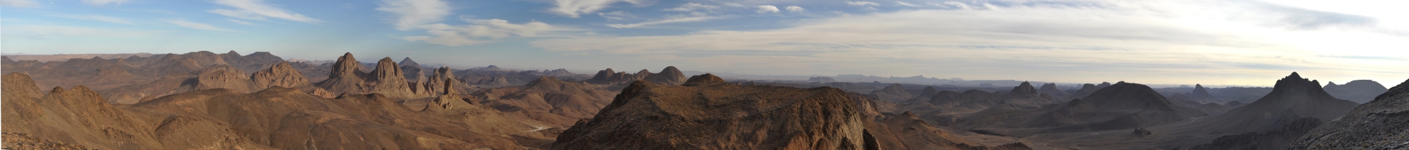
This mountainous region is located about 1,500 km (930 mi) south of the capital, Algiers. The area is largely rocky desert with an average elevation of more than 900 m (3,000 ft) above sea level. The highest peak, Mount Tahat, is at 2,908 m (9,541 ft).[1] The mountains are primarily composed of metamorphic rock approximately 2 billion years old, although there are areas where more recent volcanic activity has laid down much newer rock.[1] Several of the more dramatic peaks, such as Ilamen, are the result of erosion wearing away extinct volcano domes, leaving behind the more resistant material that plugged the volcanic cores.[1]

Assekrem is a famous and often visited point where Charles de Foucauld built a hermitage in 1911.[2] The main city near the Hoggar Mountains is Tamanrasset, built in a desert valley or wadi.
Environment
The Hoggar Mountain range typically experiences hot summers, with a cold winter climate. Temperatures fall below freezing in the winter. Rainfall is rare and sporadic year-round. However, since the climate is less extreme than in most other areas of the Sahara, the Hoggar Mountains are a major location for biodiversity, including number of relict species. The Hoggar Mountains are part of the West Saharan montane xeric woodlands ecoregion.
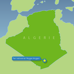
The Hoggar mountains are home to the Ahaggar National Park, one of the national parks of the country.[3] The tallest peak in the Hoggar range, Mount Tahat is located in the park area, which covers approximately 450,000 square kilometres (170,000 sq mi).[3]
Fauna and flora
Slightly to the west of the Hoggar range, a population of the endangered African wild dog (Lycaon pictus) remained viable into the 20th century, but is now thought to be extirpated within this entire region.[4]
Analysis of collected scat in 2006 showed the presence of the Northwest African cheetah in the region.[5][6] Between August 2008 and November 2010, four individuals were recorded by camera traps.[7] A single cheetah was filmed and photographed by Algerian naturalists in 2020 in the national park in the Atakor volcanic field whose peaks approach a height of 3,000 metres (9,800 ft).[8]
Relict populations of the West African crocodile persisted in the Hoggar Mountains until the early 20th century.[9]
The park also contains a population of herbivores such as the saharan subspecies of the barbary sheep and the Dorcas gazelle.[3]
Vegetation in this area includes trees such as Vachellia tortilis, Vachellia seyal, myrtle and Tamarix aphylla which are scattered throughout the area. Other plants may include Citrullus colocynthis and Calotropis procera.
Cultural significance
Prehistoric settlement is evident from extant rock paintings dating to 6000 BC.[10] The Hoggar Massif is the land of the Kel Ahaggar Tuareg.[1] The tomb of Tin Hinan, the woman believed to be the matriarch of the Tuareg, is located at Abalessa, an oasis near Tamanrasset.
The hermitage of Charles de Foucauld, which continues to be inhabited by a few Catholic monks, is at the top of the Assekrem plateau in the Hoggar Mountains.[11]
Panoramic view
See also
- France and weapons of mass destruction; Saharan facilities
- Saharan rock art
- Teffedest Mountains
References
- Scheffel, Richard L.; Wernet, Susan J., eds. (1980). Natural Wonders of the World. United States of America: Reader's Digest Association, Inc. pp. 32–33. ISBN 0-89577-087-3.
- Sattin, Anthony Ham, Nana Luckham, Anthony (2007). Algeria (1st ed.). Footscray, Vic.: Lonely Planet. p. 188. ISBN 978-1741790993.
assekrem.
- "Ahaggar National Park, Saharan Algeria Region, Algeria". Algeria.com. Retrieved 27 May 2020.
- Hogan, C. Michael (2009). "Painted Hunting Dog: Lycaon pictus". GlobalTwitcher.com. N. Stromberg. Archived from the original on December 9, 2010.
- Busby, G. B. J. (2006). The Cheetah (Acinonyx jubatus) in Northern Africa : A Non-Invasive Genetic Study of Carnivores from the Ahaggar Mountains, Southern Algeria (PDF) (Master's thesis). Imperial College London. Archived from the original (PDF) on 2020-09-21. Retrieved 2010-09-22.
- Busby, G. B. J.; Gottelli, D.; Durant, S.; et al. (November 2006). "A Report from the Sahelo Saharan Interest Group - Office du Parc National de l'Ahaggar Survey, Algeria (March 2005) - Part 5: Using Molecular Genetics to study the Presence of Endangered Carnivores" (PDF). Unpublished Report. Archived from the original (PDF) on 2016-03-04. Retrieved 2010-09-22.
- Belbachir, F.; Pettorelli, N.; Wacher, T.; Belbachir-Bazi, A. & Durant, S.M. (2015). "Monitoring rarity: the critically endangered Saharan cheetah as a flagship species for a threatened ecosystem". PLOS ONE. 10 (1): e0115136. Bibcode:2015PLoSO..1015136B. doi:10.1371/journal.pone.0115136. PMC 4309643. PMID 25629400.
- Agence France-Presse (24 May 2020). "Critically Endangered Saharan Cheetah Seen in Algeria For The First Time in a Decade". Sciencealert.com. Retrieved 27 May 2020.
- Brito, J. C.; Martínez-Freiría, F.; Sierra, P.; et al. (2011). "Crocodiles in the Sahara Desert: An Update of Distribution, Habitats and Population Status for Conservation Planning in Mauritania". PLOS One. 6 (2): e14734. Bibcode:2011PLoSO...614734B. CiteSeerX 10.1.1.293.4325. doi:10.1371/journal.pone.0014734. PMC 3045445. PMID 21364897.
- Haggett, Peter (2001). Encyclopedia of World Geography. Marshall Cavendish. ISBN 0-7614-7289-4.
- Ham, Anthony (2007). Algeria. Lonely Planet. p. 188.
Further reading
- Keenan, Jeremy (1977). The Tuareg: People of Ahaggar. London: Allen Lane, Penguin Books. ISBN 0-7139-0636-7.
External links
- (in French) A website about the park
- Park data on UNEP-WPMC
- Ahaggar National Park - The Biodiverse Home of the Saharan Cheetah
| Tell Atlas |
|
|---|---|
| Saharan Atlas |
|
| Saharan massifs |
|
| Peaks |
|
| |
Authority control | |
|---|---|
| General |
|
| National libraries | |
На других языках
[de] Ahaggar
Das Ahaggar (auch der Hoggar, arabisch جبال هقار, DMG Ǧibāl Haqār, tamazight ⵉⴷⵓⵔⴰⵔ ⵏ ⴰⵀⴰⴳⴳⴰⵔ Idurar n Ahaggar) ist ein Gebirge vulkanischen Ursprungs im Süden Algeriens. Zum größten Teil liegt das Ahaggar in Algerien, umfasst aber auch Teile des Niger im Süden.- [en] Hoggar Mountains
[es] Ahaggar
El macizo de Ahaggar o de Hoggar (en árabe, جبال هقار, en tuareg: Idurar Uhaggar) es una cadena de montañas localizada en el oeste del Sáhara, al sur de Argelia, a unos a 1500 km al sur de la capital Argel. Administrativamente, el macizo pertenece a la provincia de Tamanrasset.[fr] Hoggar
Le Hoggar (en tamazight touareg Idurar Uhaggar ou Tassili Wan Ahaggar, ⵜⴰⵙⵙⵉⵍⵉ ⵏ ⵡⴰⵏ ⴰⵀⴰⴳⴰⵔ, en arabe جبال هقار) est un massif montagneux qui s'élève à 2 918 m d'altitude dans le Sud de l'Algérie, au cœur du Sahara.[it] Ahaggar
Il massiccio dell'Ahaggar è un complesso montuoso, in Nord Africa, nel cuore del deserto del Sahara, nel sud dell'Algeria. Prende il nome dalla popolazione che tradizionalmente vi abita, i tuareg Kel Ahaggar.[ru] Ахаггар
Аха́ггар (араб. جبال هقار, тамашек Ahaggar) — нагорье в Сахаре, на юге Алжира, к юго-востоку от города Таманрассет. Оно представляет собой выступ кристаллического фундамента высотой в среднем 2000 м[1]. Высшая точка — гора Тахат, 2918 м (по другим сведениям — 3003 м[1]), которая представляет собой также высшую точку Алжира.Другой контент может иметь иную лицензию. Перед использованием материалов сайта WikiSort.org внимательно изучите правила лицензирования конкретных элементов наполнения сайта.
WikiSort.org - проект по пересортировке и дополнению контента Википедии