geo.wikisort.org - Mountains
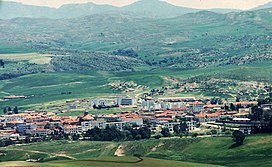
The Bibans or Biban Range (Arabic: البيبان, Kabylian: Tiggoura, French: Chaîne des Bibans or Les Bibans) are a chain of mountains in northern Algeria, bordering the south of Kabylie.
| Bibans | |
|---|---|
| البيبان | |
 View of the Bibans in Sour El-Ghozlane | |
| Highest point | |
| Peak | Mansoura |
| Elevation | 1,862 m (6,109 ft) |
| Coordinates | 36°11′0″N 4°26′0″E[1] |
| Geography | |
| Parent range | Tell Atlas |

Geography
The highest summits are 1862 m high Mansoura (جبل منصورة) and 1832 m high Choukchout (جبل شوكشوط). Located to the east of the Blidean Atlas and to the west of the Hodna Mountains, the Bibans are a subrange of the Tell Atlas, part of the Atlas Mountain System.[2]
The strategic Iron Gates mountain passes are located in the range and gave their name to the Biban Mountains. The main gorge is the deep Bab al-Kabir (Big Door), cut by the Ouadi Chebba, through which the railway line between Algiers and Constantine passes. The Bab al-Saghir (Little Door) of the Oadi Buktun is located 3.5 km to the east.[3]
Some authors claim that the range was known as El Ouennougha before the French colonization of Algeria.[4] Traditionally these mountains have been populated by Kabyle people. In present days the Kabyle populations are found in the centre and the eastern part of the range, while the western end is home to Arabophone communities. Local people use to practice goat rearing and beekeeping, as well as growing olives for the production of olive oil. Ancient oil mills have been preserved in certain villages.[5]
Protected areas
The 200,000 ha Saharan Atlas National Park is a protected area located near Hammam Dhalaa on the southeastern side of the range, 15 km north of M'Sila.[6] Established in 1992, it is a refuge for about hundred Cuvier's gazelles.[7]
See also
- List of mountains in Algeria
- Iron Gates (Algeria)
- Petite Kabylie
References
- Google Earth
- L'Atlas Tellien - Chapitre III (Géologie locale)[permanent dead link]
- Charles Nodier, Journal de l'Expédition des Portes de Fer
- Youssef Benoudjit, La Kalaa des Béni Abbès : au xvie siècle, Dahlab, 1997, ISBN 9961611322
- Ouled Sidi Brahim Les Bibans Algeria
- Saharan Atlas National Park - Saharan Atlas, Algeria[permanent dead link]
- David P. Mallon, Steven Charles Kingswood eds. Antelopes: North Africa, the Middle East, and Asia. p. 27
External links
 Media related to Bibans at Wikimedia Commons
На других языках
[de] Bibans
Die Bibans (arabisch البيبان, kabylisch ⵜⵉⴳⴳⵓⵔⴰ .mw-parser-output .Latn{font-family:"Akzidenz Grotesk","Arial","Avant Garde Gothic","Calibri","Futura","Geneva","Gill Sans","Helvetica","Lucida Grande","Lucida Sans Unicode","Lucida Grande","Stone Sans","Tahoma","Trebuchet","Univers","Verdana"}Tiggoura) sind eine Kette von Bergen im nördlichen Algerien, die im Süden an die Kabylei grenzen. Die höchsten Gipfel sind der 1862 m hohe Mansoura (جبل منصورة) und der 1832 m hohe Choukchout (شوكشوط). Die Bibans sind ein Gebirgszug des Tellatlas. Alle strategisch wichtigen Überwachungspunkte liegen auf Höhe der Pässe der Biban-Berge (Iron Gates). Die bedeutendste Schlucht ist das Bab al-Kabir ‚große Tor' und verbindet über das Wadi Chebba Algier mit der Eisenbahn. Etwa 2 km östlich liegt das Bab al-Saghir ‚das kleine Tor‘.- [en] Bibans
[fr] Bibans
Les Bibans (en arabe : البيبان, al-Bībān ; en berbère : ⵉⵡⴰⵏⵓⵖⴻⵏ, Iwanughen) sont une chaîne de montagnes qui culmine à 1 862 mètres d'altitude dans le Nord de l'Algérie, entre la vallée du fleuve Sahel-Soummam et les hautes plaines de la Medjana dans la « Petite Kabylie » et constituant une partie de l'Atlas tellien.Другой контент может иметь иную лицензию. Перед использованием материалов сайта WikiSort.org внимательно изучите правила лицензирования конкретных элементов наполнения сайта.
WikiSort.org - проект по пересортировке и дополнению контента Википедии
