geo.wikisort.org - Mountains
The Appalachian Mountains,[lower-alpha 1] often called the Appalachians, (French: Appalaches), are a system of mountains in eastern to northeastern North America. The Appalachians first formed roughly 480 million years ago during the Ordovician Period. They once reached elevations similar to those of the Alps and the Rocky Mountains before experiencing natural erosion.[4][5] The Appalachian chain is a barrier to east–west travel, as it forms a series of alternating ridgelines and valleys oriented in opposition to most highways and railroads running east–west.
| Appalachian Mountains | |
|---|---|
| Appalachians | |
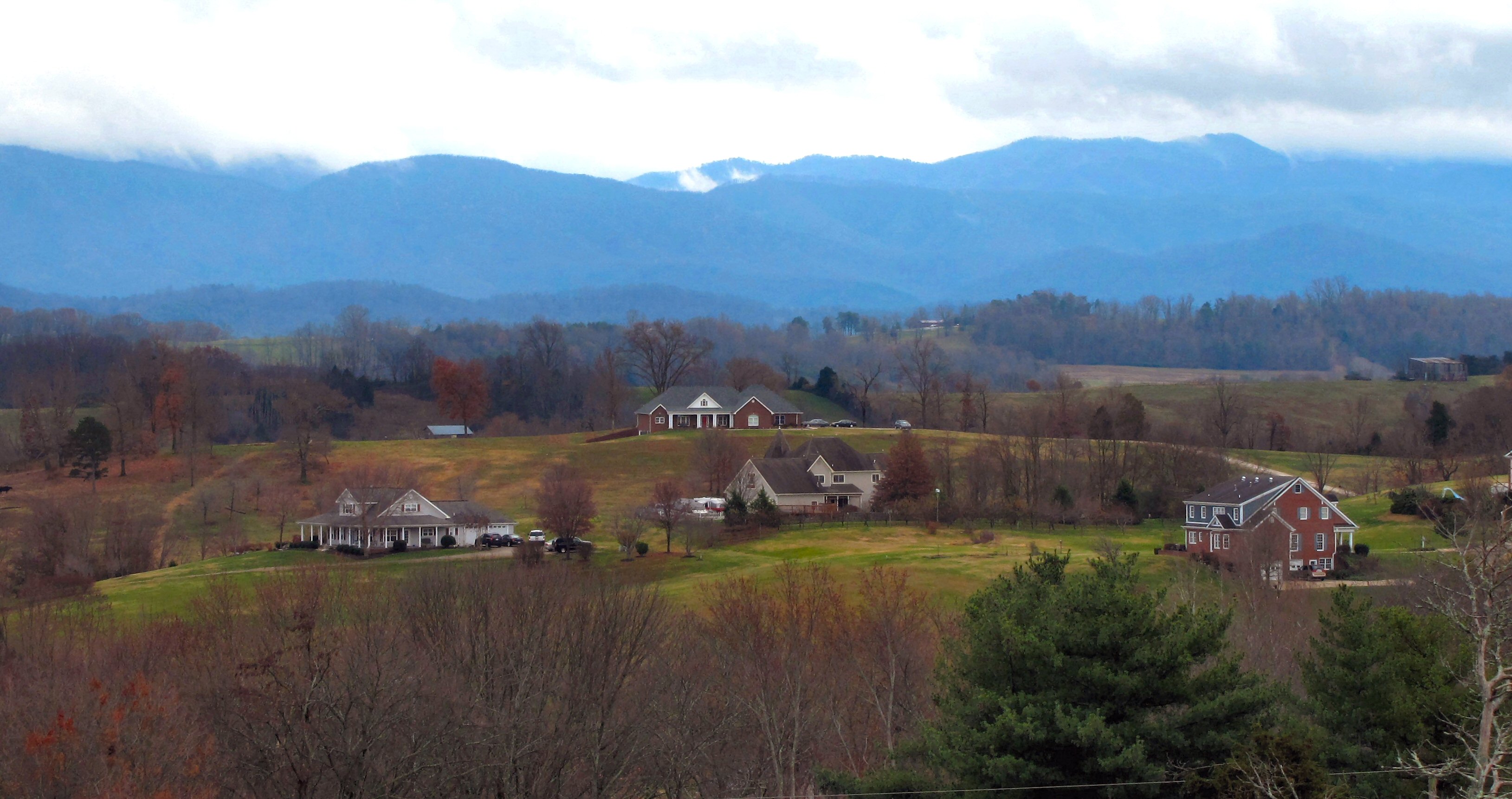
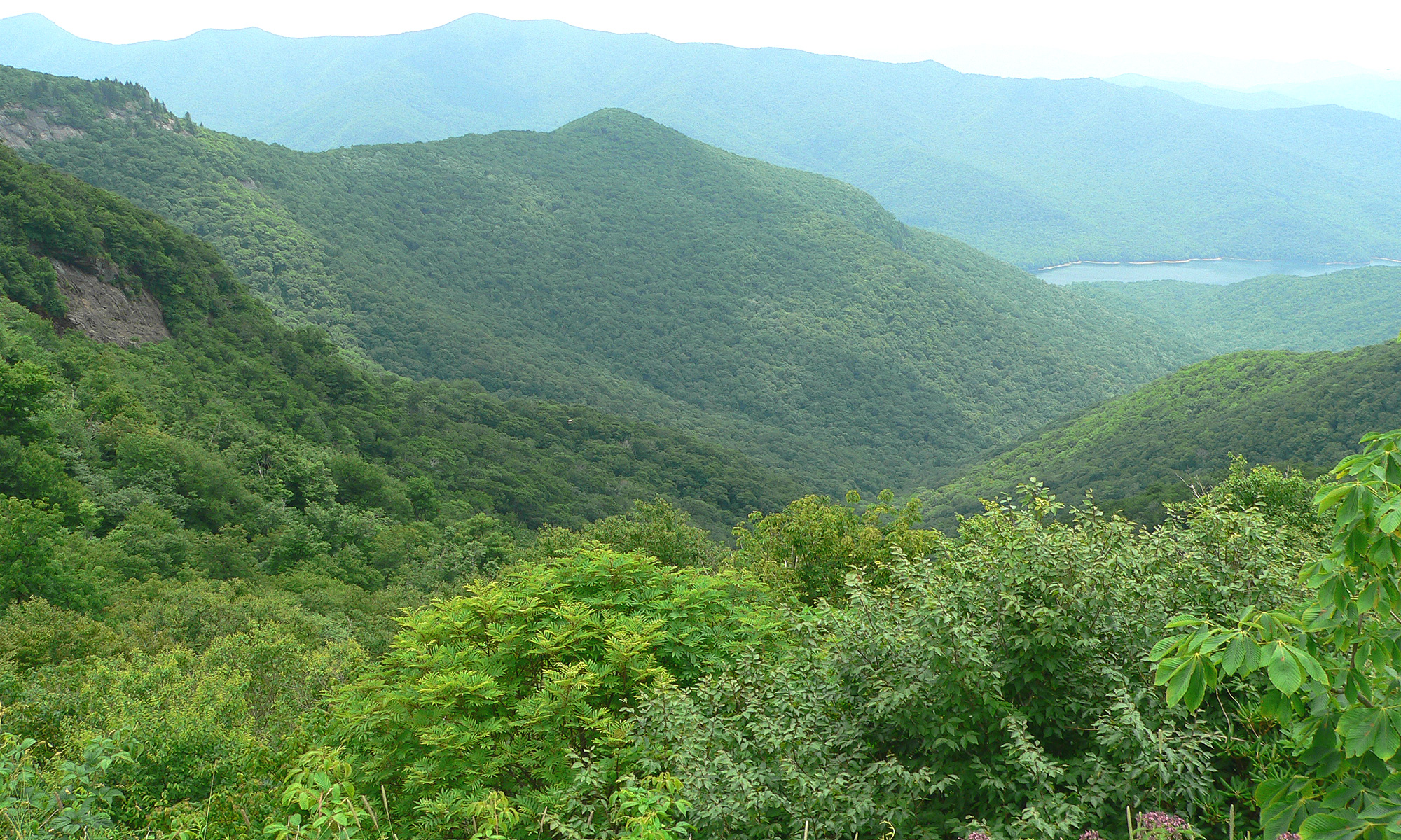
 The Appalachian Mountains (in the background) and Penns Valley, Pennsylvania in the foreground, October 2021 | |
| Highest point | |
| Peak | Mount Mitchell |
| Elevation | 6,684 ft (2,037 m) |
| Dimensions | |
| Length | 1,500 mi (2,400 km) |
| Geography | |

| |
| Countries | United States, Canada and France |
| Provinces/States | Newfoundland and Labrador[1][2], Saint Pierre and Miquelon, Québec, Nova Scotia, New Brunswick, Maine, New Hampshire, Vermont, Massachusetts, Connecticut, New York, New Jersey, Pennsylvania, Maryland, Washington, D.C., Delaware, Virginia, West Virginia, Ohio, Kentucky, Tennessee, North Carolina, South Carolina, Georgia and Alabama |
| Range coordinates | 40°N 78°W |
| Geology | |
| Orogeny | Taconic, Acadian, Alleghanian |
| Age of rock | Ordovician–Permian |
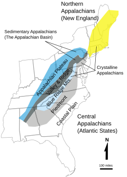
Definitions vary on the precise boundaries of the Appalachians. The United States Geological Survey (USGS) defines the Appalachian Highlands physiographic division as consisting of 13 provinces: the Atlantic Coast Uplands, Eastern Newfoundland Atlantic, Maritime Acadian Highlands, Maritime Plain, Notre Dame and Mégantic Mountains, Western Newfoundland Mountains, Piedmont, Blue Ridge, Valley and Ridge, St. Lawrence Valley, Appalachian Plateaus, and New England province.[6][7] The Appalachians do not include the Adirondack Mountains, a distinct and growing range that is a part of the Canadian Shield and belongs to the Grenville Orogeny.[8][9][10]
Overview
The mountain range is mostly in the United States, though it extends into southeastern Canada, forming a zone from 100 to 300 mi (160 to 480 km) wide, running from the island of Newfoundland 1,500 mi (2,400 km) southwestward to Central Alabama in the United States.[discuss] The range covers parts of the islands of Saint Pierre and Miquelon, an overseas territory of France. The system is divided into a series of ranges with the individual mountains averaging around 3,000 ft (910 m). The highest of the group is Mount Mitchell in North Carolina at 6,684 feet (2,037 m), which is the highest point in the United States east of the Mississippi River.
The term Appalachian refers to several different regions associated with the mountain range. Most broadly, it refers to the entire mountain range with its surrounding hills and the dissected plateau region. The term is often used more restrictively to refer to regions in the central and southern Appalachian Mountains, usually including areas in the states of Kentucky, Tennessee, Virginia, Maryland, West Virginia, and North Carolina, and sometimes extending as far south as northern Alabama, Georgia, and western South Carolina, and as far north as Pennsylvania, southern and east central Ohio, Lower New York and the Southern Tier region of New York.
The Ouachita Mountains in Arkansas and Oklahoma were originally part of the Appalachians as well but became disconnected through geologic history.
Origin of the name
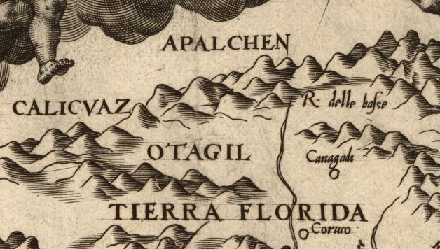
While exploring inland along the northern coast of Florida in 1528, the members of the Narváez expedition, including Álvar Núñez Cabeza de Vaca, found a Native American village near present-day Tallahassee, Florida whose name they transcribed as Apalchen or Apalachen [a.paˈla.tʃɛn]. The name was soon altered by the Spanish to Apalachee and used as a name for the tribe and region spreading well inland to the north. Pánfilo de Narváez's expedition first entered Apalachee territory on June 15, 1528, and applied the name. Now spelled "Appalachian," it is the fourth-oldest surviving European place-name in the US.[11]
After the 1540 expedition of Hernando de Soto, Spanish cartographers began to apply the name of the tribe to the mountains themselves. The first cartographic appearance of Apalchen is on Diego Gutiérrez's map of 1562; the first use for the mountain range is the map of Jacques le Moyne de Morgues in 1565.[12]
The name was not commonly used for the whole mountain range until the late 19th century. A competing and often more popular[according to whom?] name was the "Allegheny Mountains", "Alleghenies", and even "Alleghania". In the early 19th century, Washington Irving proposed renaming the United States either Appalachia or Alleghania.[13]
In U.S. dialects in the southern regions of the Appalachians, the word is pronounced /ˌæpəˈlætʃɪnz/, with the third syllable sounding like "latch". In northern parts of the mountain range, it is pronounced /ˌæpəˈleɪtʃɪnz/ or /ˌæpəˈleɪʃɪnz/; the third syllable is like "lay", and the fourth "chins" or "shins".[14] There is often great debate between the residents of the regions as to which pronunciation is the more correct one. Elsewhere, a commonly accepted pronunciation for the adjective Appalachian is /ˌæpəˈlætʃiən/, with the last two syllables "-ian" pronounced as in the word "Romanian".[15]
Geography


Regions
The Appalachian Mountains include three major sections:[16]
- Northern: The northern section runs from the Canadian province of Newfoundland and Labrador to the Hudson River. It includes the Long Range Mountains and Annieopsquotch Mountains on the island of Newfoundland, the French Territorial Collectivity of Saint-Pierre and Miquelon southwest of Newfoundland, Chic-Choc Mountains and Notre Dame Range in Quebec and New Brunswick, scattered elevations and small ranges elsewhere in Nova Scotia and New Brunswick, the Longfellow Mountains in Maine, the White Mountains in New Hampshire, the Green Mountains in Vermont, and The Berkshires in Massachusetts and Connecticut. The Metacomet Ridge Mountains in Connecticut and south-central Massachusetts, although contained within the Appalachian province, is a younger system and not geologically associated with the Appalachians. The Monteregian Hills, which cross the Green Mountains in Quebec, are also unassociated with the Appalachians. The Adirondack Mountains in New York are sometimes included with maps of the Appalachian chain but are in fact a southern extension of the Laurentian Mountains of Canada.[8][9][10]
- Central: The central section runs from the Hudson Valley in New York to the New River through the Lehigh Valley and central Pennsylvania and western Maryland to western Virginia and West Virginia. The central region comprises the Valley Ridges between the Allegheny Front of the Allegheny Plateau and the Great Appalachian Valley, the New York–New Jersey Highlands, the Taconic Mountains in New York, and a large portion of the Blue Ridge. In addition to the true folded mountains, known as the ridge and valley province, the area of dissected plateau to the north and west of the mountains is usually grouped with the Appalachians. This includes the Catskill Mountains of Lower New York, the Poconos in Pennsylvania, and the Allegheny Plateau of New York's Southern Tier region, western Pennsylvania, eastern Ohio and northern West Virginia.
- Southern: The southern section runs from the New River and consists of the prolongation of the Blue Ridge Mountains, which is divided into the Western Blue Ridge (or Unaka) Front and the Eastern Blue Ridge Front, the Ridge-and-Valley Appalachians, and the Cumberland Plateau. This same plateau is known as the Cumberland Plateau in southern West Virginia, eastern Kentucky, western Virginia, eastern Tennessee, and northern Alabama.
The dissected plateau area, while not actually made up of geological mountains, is popularly called "mountains," especially in eastern Kentucky and West Virginia, and while the ridges are not high, the terrain is extremely rugged. In Ohio and New York, some of the plateau has been glaciated, which has rounded off the sharp ridges and filled the valleys to some extent. The glaciated regions are usually referred to as hill country rather than mountains.
The Appalachian region is generally considered the geographical divide between the eastern seaboard of the United States and the Midwest region of the country. The Eastern Continental Divide follows the Appalachian Mountains from Pennsylvania to Georgia.
The Appalachian Trail is a 2,175-mile (3,500 km) hiking trail that runs all the way from Mount Katahdin in Maine to Springer Mountain in Georgia, passing over or past a large part of the Appalachian system. The International Appalachian Trail is an extension of this hiking trail into the Canadian portion of the Appalachian range in New Brunswick and Quebec.
Chief summits

The Appalachian belt includes, with the ranges enumerated above, the plateaus sloping southward to the Atlantic Ocean in New England, and south-eastward to the border of the coastal plain through the central and southern Atlantic states; and on the north-west, the Allegheny and Cumberland plateaus declining toward the Great Lakes and the interior plains. A remarkable feature of the belt is the longitudinal chain of broad valleys, including the Great Appalachian Valley, which in the southerly sections divides the mountain system into two unequal portions, but in the northernmost lies west of all the ranges possessing typical Appalachian features, and separates them from the Adirondack group. The mountain system has no axis of dominating altitudes, but in every portion, the summits rise to rather uniform heights, and, especially in the central section, the various ridges and intermontane valleys have the same trend as the system itself. None of the summits reaches the region of perpetual snow.[16]
Mountains of the Long Range in Newfoundland reach heights of nearly 2,700 ft (800 m). In the Chic-Choc and Notre Dame mountain ranges in Quebec, the higher summits rise above 4,000 ft (1,200 m) in elevation. Isolated peaks and small ranges in Nova Scotia and New Brunswick vary from 1,000 to 2,700 ft (300 to 800 m). In Maine, several peaks exceed 4,000 ft (1,200 m), including Mount Katahdin at 5,267 feet (1,605 m). In New Hampshire, many summits rise above 5,000 ft (1,500 m), including Mount Washington in the White Mountains at 6,288 ft (1,917 m), Adams at 5,771 ft (1,759 m), Jefferson at 5,712 ft (1,741 m), Monroe at 5,380 ft (1,640 m), Madison at 5,367 ft (1,636 m), Lafayette at 5,249 feet (1,600 m), and Lincoln at 5,089 ft (1,551 m). In the Green Mountains the highest point, Mt. Mansfield, is 4,393 ft (1,339 m) in elevation; others include Killington Peak at 4,226 ft (1,288 m), Camel's Hump at 4,083 ft (1,244 m), Mt. Abraham at 4,006 ft (1,221 m), and a number of other heights exceeding 3,000 ft (900 m).[16]
In Pennsylvania, there are over sixty summits that rise over 2,500 ft (800 m); the summits of Mount Davis and Blue Knob rise over 3,000 ft (900 m). In Maryland, Eagle Rock and Dans Mountain are conspicuous points reaching 3,162 ft (964 m) and 2,882 ft (878 m) respectively. On the same side of the Great Valley, south of the Potomac, are the Pinnacle 3,007 feet (917 m) and Pidgeon Roost 3,400 ft (1,000 m).[16] In West Virginia, more than 150 peaks rise above 4,000 ft (1,200 m), including Spruce Knob 4,863 ft (1,482 m), the highest point in the Allegheny Mountains. A number of other points in the state rise above 4,800 ft (1,500 m). Cheat Mountain (Snowshoe Mountain) at Thorny Flat 4,848 ft (1,478 m) and Bald Knob 4,842 ft (1,476 m) are among the more notable peaks in West Virginia.

The Blue Ridge Mountains, rising in southern Pennsylvania and there known as South Mountain, attain elevations of about 2,000 ft (600 m) in that state. South Mountain achieves its highest point just below the Mason-Dixon line in Maryland at Quirauk Mountain 2,145 ft (654 m) and then diminishes in height southward to the Potomac River. Once in Virginia, the Blue Ridge again reaches 2,000 ft (600 m) and higher. In the Virginia Blue Ridge, the following are some of the highest peaks north of the Roanoke River: Stony Man 4,031 ft (1,229 m), Hawksbill Mountain 4,066 ft (1,239 m), Apple Orchard Mountain 4,225 ft (1,288 m) and Peaks of Otter 4,001 and 3,875 ft (1,220 and 1,181 m). South of the Roanoke River, along the Blue Ridge, are Virginia's highest peaks including Whitetop Mountain 5,520 ft (1,680 m) and Mount Rogers 5,729 ft (1,746 m), the highest point in the Commonwealth.
Chief summits in the southern section of the Blue Ridge are located along two main crests—the Western or Unaka Front along the Tennessee-North Carolina border and the Eastern Front in North Carolina—or one of several "cross ridges" between the two main crests. Major subranges of the Eastern Front include the Black Mountains, Great Craggy Mountains, and Great Balsam Mountains, and its chief summits include Grandfather Mountain 5,964 ft (1,818 m) near the Tennessee-North Carolina border, Mount Mitchell 6,684 ft (2,037 m) in the Blacks, and Black Balsam Knob 6,214 ft (1,894 m) and Cold Mountain 6,030 ft (1,840 m) in the Great Balsams. The Western Blue Ridge Front is subdivided into the Unaka Range, the Bald Mountains, the Great Smoky Mountains, and the Unicoi Mountains, and its major peaks include Roan Mountain 6,285 ft (1,916 m) in the Unakas, Big Bald 5,516 ft (1,681 m) and Max Patch 4,616 ft (1,407 m) in the Bald Mountains, Clingmans Dome 6,643 ft (2,025 m), Mount Le Conte 6,593 feet (2,010 m), and Mount Guyot 6,621 ft (2,018 m) in the Great Smokies, and Big Frog Mountain 4,224 ft (1,287 m) near the Tennessee-Georgia-North Carolina border. Prominent summits in the cross ridges include Waterrock Knob (6,292 ft (1,918 m)) in the Plott Balsams. Across northern Georgia, numerous peaks exceed 4,000 ft (1,200 m), including Brasstown Bald, the state's highest, at 4,784 ft (1,458 m) and 4,696 ft (1,431 m) Rabun Bald. In north-central Alabama, Mount Cheaha rises prominently to 1,445 feet (440 m) over its surroundings, as part of the southernmost spur of the Blue Ridge Mountains.
Drainage
![Paleogeographic reconstruction showing the Appalachian Basin area during the Middle Devonian period[17]](http://upload.wikimedia.org/wikipedia/commons/thumb/3/3b/Eastern_North_American_Paleogeograpy_Middle_Devonian.png/260px-Eastern_North_American_Paleogeograpy_Middle_Devonian.png)
There are many geological issues concerning the rivers and streams of the Appalachians. In spite of the existence of the Great Appalachian Valley, many of the main rivers are transverse to the mountain system axis. The drainage divide of the Appalachians follows a tortuous course that crosses the mountainous belt just north of the New River in Virginia. South of the New River, rivers head into the Blue Ridge, cross the higher Unakas, receive important tributaries from the Great Valley, and traversing the Cumberland Plateau in spreading gorges (water gaps), escape by way of the Cumberland River and the Tennessee River rivers to the Ohio River and the Mississippi River, and thence to the Gulf of Mexico. In the central section, north of the New River, the rivers, rising in or just beyond the Valley Ridges, flow through great gorges to the Great Valley, and then across the Blue Ridge to tidal estuaries penetrating the coastal plain via the Roanoke River, James River, Potomac River, and Susquehanna River.[16]
In the northern section the height of land lies on the inland side of the mountainous belt, and thus the main lines of drainage run from north to south, exemplified by the Hudson River.[16] However, the valley through which the Hudson River flows was cut by the gigantic glaciers of the ice ages—the same glaciers that deposited their terminal moraines in southern New York and formed the east–west Long Island.
Geology
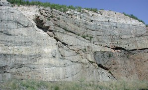
A look at rocks that are exposed in today's Appalachian mountains reveals elongated belts of folded and thrust faulted marine sedimentary rocks, volcanic rocks and slivers of ancient ocean floor, which provides strong evidence that these rocks were deformed during plate collision. The birth of the Appalachian ranges, some 480 million years ago, marks the first of several mountain-building plate collisions that culminated in the construction of the supercontinent Pangaea with the Appalachians near the center. Because North America and Africa were connected, the Appalachians formed part of the same mountain chain as the Little Atlas in Morocco. This mountain range, known as the Central Pangean Mountains, extended into Scotland, before the Mesozoic Era opening of the Iapetus Ocean, from the North America/Europe collision (See Caledonian orogeny).
During the middle Ordovician Period (about 496–440 million years ago), a change in plate motions set the stage for the first Paleozoic mountain-building event (Taconic orogeny) in North America. The once-quiet Appalachian passive margin changed to a very active plate boundary when a neighboring oceanic plate, the Iapetus, collided with and began sinking beneath the North American craton. With the birth of this new subduction zone, the early Appalachians were born. Volcanoes grew along the continental margin coincident with the initiation of subduction. Thrust faulting uplifted and warped older sedimentary rock laid down on the passive margin. As the mountains rose, erosion began to wear them down over time. Streams carried rock debris downslope to be deposited in nearby lowlands. The Taconic Orogeny was just the first of a series of mountain building plate collisions that contributed to the formation of the Appalachians, culminating in the collision of North America and Africa (see Alleghanian orogeny).[18]
By the end of the Mesozoic Era, the Appalachian Mountains had been eroded to an almost flat plain.[18] It was not until the region was uplifted during the Cenozoic Era that the distinctive topography of the present formed.[19] Uplift rejuvenated the streams, which rapidly responded by cutting downward into the ancient bedrock. Some streams flowed along weak layers that define the folds and faults created many millions of years earlier. Other streams downcut so rapidly that they cut right across the resistant folded rocks of the mountain core, carving canyons across rock layers and geologic structures.
Mineral resources
The Appalachian Mountains contain major deposits of anthracite coal as well as bituminous coal. In the folded mountains the coal is in metamorphosed form as anthracite, represented by the Coal Region of northeastern Pennsylvania. The bituminous coal fields of western Pennsylvania, western Maryland, southeastern Ohio, eastern Kentucky, southwestern Virginia, and West Virginia contain the sedimentary form of coal.[20] The mountain top removal method of coal mining, in which entire mountain tops are removed, is currently threatening vast areas and ecosystems of the Appalachian Mountain region.[21] The surface coal mining that started in the 1940s has significantly impacted the central Appalachian Mountains in Kentucky, Tennessee, Virginia and West Virginia. Early mining methods were unregulated and mined land reclamation research, including acid base reaction, was led by the West Virginia University in the 1960s and 1970s. West Virginia developed rigorous mine reclamation standards for state coal mines in the late 1960s. Regulations were introduced by most federal states to protect the Appalachian Mountains by the late 1960s. Social and political activism brought about the Surface Mining Control and Reclamation Act of 1977.[22]
The 1859 discovery of commercial quantities of petroleum in the Appalachian Mountains of western Pennsylvania started the modern United States petroleum industry.[23] Recent discoveries of commercial natural gas deposits in the Marcellus Shale formation and Utica Shale formations have once again focused oil industry attention on the Appalachian Basin.
Some plateaus of the Appalachian Mountains contain metallic minerals such as iron and zinc.[24]
Ecology
The Appalachians, particularly the Central and Southern regions, is one of the most biodiverse places in North America.[25] The north–south orientation of the long ridges and valleys contributes to the high number of plant and animal species. Species were able to migrate through these from either direction during alternating periods of warming and cooling, settling in the microclimates that best suited them.[26]
Flora

The flora of the Appalachians are diverse and vary primarily in response to geology, latitude, elevation and moisture availability. Geobotanically, they constitute a floristic province of the North American Atlantic Region. The Appalachians consist primarily of deciduous broad-leaf trees and evergreen needle-leaf conifers, but also contain the evergreen broad-leaf American holly (Ilex opaca), and the deciduous needle-leaf conifer, the tamarack, or eastern larch (Larix laricina).
The dominant northern and high elevation conifer is the red spruce (Picea rubens), which grows from near sea level to above 4,000 ft (1,200 m) above sea level (asl) in northern New England and southeastern Canada. It also grows southward along the Appalachian crest to the highest elevations of the southern Appalachians, as in North Carolina and Tennessee. In the central Appalachians it is usually confined above 3,000 ft (900 m) asl, except for a few cold valleys in which it reaches lower elevations. In the southern Appalachians, it is restricted to higher elevations. Another species is the black spruce (Picea mariana), which extends farthest north of any conifer in North America, is found at high elevations in the northern Appalachians, and in bogs as far south as Pennsylvania.
The Appalachians are also home to two species of fir, the boreal balsam fir (Abies balsamea), and the southern high elevation endemic, Fraser fir (Abies fraseri). Fraser fir is confined to the highest parts of the southern Appalachian Mountains, where along with red spruce it forms a fragile ecosystem known as the Southern Appalachian spruce–fir forest. Fraser fir rarely occurs below 5,500 ft (1,700 m), and becomes the dominant tree type at 6,200 ft (1,900 m).[27] By contrast, balsam fir is found from near sea level to the tree line in the northern Appalachians, but ranges only as far south as Virginia and West Virginia in the central Appalachians, where it is usually confined above 3,900 ft (1,200 m) asl, except in cold valleys. Curiously, it is associated with oaks in Virginia. The balsam fir of Virginia and West Virginia is thought by some to be a natural hybrid between the more northern variety and Fraser fir. While red spruce is common in both upland and bog habitats, balsam fir, as well as black spruce and tamarack, are more characteristic of the latter. However, balsam fir also does well in soils with a pH as high as 6.[28]

Eastern or Canada hemlock (Tsuga canadensis) is another important evergreen needle-leaf conifer that grows along the Appalachian chain from north to south but is confined to lower elevations than red spruce and the firs. It generally occupies richer and less acidic soils than the spruce and firs and is characteristic of deep, shaded and moist mountain valleys and coves. It is, unfortunately, subject to the hemlock woolly adelgid (Adelges tsugae), an introduced insect, that is rapidly extirpating it as a forest tree. Less abundant, and restricted to the southern Appalachians, is Carolina hemlock (Tsuga caroliniana). Like Canada hemlock, this tree suffers severely from the hemlock woolly adelgid.
Several species of pines characteristic of the Appalachians are eastern white pine (Pinus strobus), Virginia pine (Pinus virginiana), pitch pine (Pinus rigida), Table Mountain pine (Pinus pungens) and shortleaf pine (Pinus echinata). Red pine (Pinus resinosa) is a boreal species that forms a few high elevation outliers as far south as West Virginia. All of these species except white pine tend to occupy sandy, rocky, poor soil sites, which are mostly acidic in character. White pine, a large species valued for its timber, tends to do best in rich, moist soil, either acidic or alkaline in character. Pitch pine is also at home in acidic, boggy soil, and Table Mountain pine may occasionally be found in this habitat as well. Shortleaf pine is generally found in warmer habitats and at lower elevations than the other species. All the species listed do best in open or lightly shaded habitats, although white pine also thrives in shady coves, valleys, and on floodplains.
The Appalachians are characterized by a wealth of large, beautiful deciduous broadleaf (hardwood) trees. Their occurrences are best summarized and described in E. Lucy Braun's 1950 classic, Deciduous Forests of Eastern North America (Macmillan, New York). The most diverse and richest forests are the mixed-mesophytic or medium-moisture types, which are largely confined to rich, moist montane soils of the southern and central Appalachians, particularly in the Cumberland and Allegheny Mountains, but also thrive in the southern Appalachian coves. Characteristic canopy species are white basswood (Tilia heterophylla), yellow buckeye (Aesculus octandra), sugar maple (Acer saccharum), American beech (Fagus grandifolia), tuliptree (Liriodendron tulipifera), white ash (Fraxinus americana) and yellow birch (Betula alleganiensis). Other common trees are red maple (Acer rubrum), shagbark and bitternut hickories (Carya ovata and C. cordiformis) and black or sweet birch (Betula lenta). Small understory trees and shrubs include flowering dogwood (Cornus florida), hophornbeam (Ostrya virginiana), witch-hazel (Hamamelis virginiana) and spicebush (Lindera benzoin). There are also hundreds of perennial and annual herbs, among them such herbal and medicinal plants as American ginseng (Panax quinquefolius), goldenseal (Hydrastis canadensis), bloodroot (Sanguinaria canadensis) and black cohosh (Cimicifuga racemosa).
The foregoing trees, shrubs, and herbs are also more widely distributed in less rich mesic forests that generally occupy coves, stream valleys and flood plains throughout the southern and central Appalachians at low and intermediate elevations. In the northern Appalachians and at higher elevations of the central and southern Appalachians these diverse mesic forests give way to less diverse northern hardwood forests with canopies dominated only by American beech, sugar maple, American basswood (Tilia americana) and yellow birch and with far fewer species of shrubs and herbs.
Drier and rockier uplands and ridges are occupied by oak–chestnut forests dominated by a variety of oaks (Quercus spp.), hickories (Carya spp.) and, in the past, by the American chestnut (Castanea dentata). The American chestnut was virtually eliminated as a canopy species by the introduced fungal chestnut blight (Cryphonectaria parasitica), but lives on as sapling-sized sprouts that originate from roots, which are not killed by the fungus. In present-day forest canopies, chestnut has been largely replaced by oaks.
The oak forests of the southern and central Appalachians consist largely of black, northern red, white, chestnut and scarlet oaks (Quercus velutina, Q. rubra, Q. alba, Q. prinus and Q. coccinea) and hickories, such as the pignut (Carya glabra) in particular. The richest forests, which grade into mesic types, usually in coves and on gentle slopes, have dominantly white and northern red oaks, while the driest sites are dominated by chestnut oak, or sometimes by scarlet or northern red oaks. In the northern Appalachians the oaks, except for white and northern red, drop out, while the latter extends farthest north.

The oak forests generally lack the diverse small tree, shrub and herb layers of mesic forests. Shrubs are generally ericaceous, and include the evergreen mountain laurel (Kalmia latifolia), various species of blueberries (Vaccinium spp.), black huckleberry (Gaylussacia baccata), a number of deciduous rhododendrons (azaleas), and smaller heaths such as teaberry (Gaultheria procumbens) and trailing arbutus (Epigaea repens). The evergreen great rhododendron (Rhododendron maximum) is characteristic of moist stream valleys. These occurrences are in line with the prevailing acidic character of most oak forest soils. In contrast, the much rarer chinquapin oak (Quercus muehlenbergii) demands alkaline soils and generally grows where limestone rock is near the surface. Hence no ericaceous shrubs are associated with it.
The Appalachian flora also include a diverse assemblage of bryophytes (mosses and liverworts), as well as fungi. Some species are rare and/or endemic. As with vascular plants, these tend to be closely related to the character of the soils and the thermal environment in which they are found.
Eastern deciduous forests are subject to a number of serious insect and disease outbreaks. Among the most conspicuous is that of the introduced gypsy moth (Lymantria dispar), which infests primarily oaks, causing severe defoliation and tree mortality. But it also has the benefit of eliminating weak individuals, and thus improving the genetic stock, as well as creating rich habitat of a type through accumulation of dead wood. Because hardwoods sprout so readily, this moth is not as harmful as the hemlock woolly adelgid. Perhaps more serious is the introduced beech bark disease complex, which includes both a scale insect (Cryptococcus fagisuga) and fungal components.

During the 19th and early 20th centuries, the Appalachian forests were subject to severe and destructive logging and land clearing, which resulted in the designation of the national forests and parks as well many state-protected areas. However, these and a variety of other destructive activities continue, albeit in diminished forms; and thus far only a few ecologically based management practices have taken hold.
Appalachian bogs are boreal ecosystems, which occur in many places in the Appalachians, particularly the Allegheny and Blue Ridge subranges.[29][30] Though popularly called bogs, many of them are technically fens.[31]

Several mountain summits in the southern Appalachians are covered with expansive open habitats (either grassy meadows or heath) known as Appalachian balds. These habitats support many unique plant and animal communities, including rare, relict species, that are adapted to the open, exposed habitat. Their origins are heavily debated; while all were formerly thought to have anthropogenic origins, more recent evidence indicates a mixed origin: many were formed by climatic conditions in the Pleistocene and kept open by Pleistocene megafauna, then by other grazing wildlife (such as bison, elk, and deer) and Native American burning practices, and finally by grazing livestock introduced by European settlers. Others, especially those dominated by introduced grasses, may be fully anthropogenic in origin. The abandonment of grazing has caused trees to encroach on many of these balds, threatening their ecosystems.[32][33]

In contrast to the largely grazing-influenced balds of the southern Appalachians, parts of the northern Appalachians such as the White Mountains. the Adirondack Mountains, and Mount Katahdin have summits covered with true alpine tundra; these ecosystems are kept clear due to extremely harsh winter storms, and support a vegetation community more akin to that of the Arctic Circle.[34][35][36]
Fauna

Animals that characterize the Appalachian forests include five species of tree squirrels. The most commonly seen is the low to moderate elevation eastern gray squirrel (Sciurus carolinensis). Occupying similar habitat is the slightly larger fox squirrel (Sciurus niger) and the much smaller southern flying squirrel (Glaucomys volans). More characteristic of cooler northern and high elevation habitat is the red squirrel (Tamiasciurus hudsonicus), whereas the Appalachian northern flying squirrel (Glaucomys sabrinus fuscus), which closely resembles the southern flying squirrel, is confined to northern hardwood and spruce–fir forests.
As familiar as squirrels are the eastern cottontail rabbit (Silvilagus floridanus) and the white-tailed deer (Odocoileus virginianus). The latter in particular has greatly increased in abundance as a result of the extirpation of the eastern wolf (Canis lupus lycaon) and the North American cougar. This has led to the overgrazing and browsing of many plants of the Appalachian forests, as well as destruction of agricultural crops. Other deer include the moose (Alces alces), found only in the north, and the elk (Cervus canadensis), which, although once extirpated, is now making a comeback, through transplantation, in the southern and central Appalachians. In Quebec, the Chic-Chocs host the only population of reindeer (Rangifer tarandus) south of the St. Lawrence River. An additional species that is common in the north but extends its range southward at high elevations to Virginia and West Virginia is the varying or snowshoe hare (Lepus americanus). However, these central Appalachian populations are scattered and very small.
Another species of great interest is the beaver (Castor canadensis), which is showing a great resurgence in numbers after its near extirpation for its pelt. This resurgence is bringing about a drastic alteration in habitat through the construction of dams and other structures throughout the mountains.
Other common forest animals are the black bear (Ursus americanus), striped skunk (Mephitis mephitis), raccoon (Procyon lotor), opossum (Didelphis virginianus), woodchuck (Marmota monax), bobcat (Lynx rufus), gray fox (Urocyon cinereoargenteus), red fox (Vulpes vulpes) and in recent years, the coyote (Canis latrans), another species favored by the advent of Europeans and the extirpation of eastern and red wolves (Canis rufus). European boars (Sus scrofa) were introduced in the early 20th century.
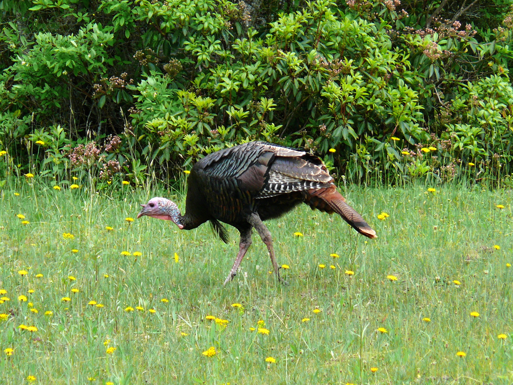
Characteristic birds of the forest are wild turkey (Meleagris gallopavo silvestris), ruffed grouse (Bonasa umbellus), mourning dove (Zenaida macroura), common raven (Corvus corax), wood duck (Aix sponsa), great horned owl (Bubo virginianus), barred owl (Strix varia), screech owl (Megascops asio), red-tailed hawk (Buteo jamaicensis), red-shouldered hawk (Buteo lineatus), and northern goshawk (Accipiter gentilis), as well as a great variety of "songbirds" (Passeriformes), like the warblers in particular.
Of great importance are the many species of salamanders and, in particular, the lungless species (Family Plethodontidae) that live in great abundance concealed by leaves and debris, on the forest floor. Most frequently seen, however, is the eastern or red-spotted newt (Notophthalmus viridescens), whose terrestrial eft form is often encountered on the open, dry forest floor. It has been estimated that salamanders represent the largest class of animal biomass in the Appalachian forests. Frogs and toads are of lesser diversity and abundance, but the wood frog (Rana sylvatica) is, like the eft, commonly encountered on the dry forest floor, while a number of species of small frogs, such as spring peepers (Pseudacris crucifer), enliven the forest with their calls. Salamanders and other amphibians contribute greatly to nutrient cycling through their consumption of small life forms on the forest floor and in aquatic habitats.
Although reptiles are less abundant and diverse than amphibians, a number of snakes are conspicuous members of the fauna. One of the largest is the non-venomous black rat snake (Elaphe obsoleta obsoleta), while the common garter snake (Thamnophis sirtalis) is among the smallest but most abundant. The Eastern copperhead (Agkistrodon contortrix) and the timber rattler (Crotalus horridus) are venomous pit vipers. There are few lizards, but the broad-headed skink (Eumeces laticeps), at up to 13 in (33 cm) in length, and an excellent climber and swimmer, is one of the largest and most spectacular in appearance and action. The most common turtle is the eastern box turtle (Terrapene carolina carolina), which is found in both upland and lowland forests in the central and southern Appalachians. Prominent among aquatic species is the large common snapping turtle (Chelydra serpentina), which occurs throughout the Appalachians.
Appalachian streams are notable for their highly diverse freshwater fish life. Among the most abundant and diverse are those of the minnow family (family Cyprinidae), while species of the colorful darters (Percina spp.) are also abundant.[37]
A characteristic fish of shaded, cool Appalachian forest streams is the wild brook or speckled trout (Salvelinus fontinalis), which is much sought after as a game fish.
See also
- Flora of the Appalachian Mountains
- Appalachia
- Appalachian League
- Appalachian Mountain Club
- Appalachian Trail
- Appalachian American
Notes
References
- "International Appalachian Trail- Newfoundland". Iatnl.ca. Archived from the original on June 4, 2010. Retrieved November 6, 2010.
- Cees R. van Staal, Mineral Deposits of Canada: Regional Metallogeny: Pre-Carboniferous tectonic evolution and metallogeny of the Canadian Appalachians Archived March 11, 2009, at the Wayback Machine, Geological Survey of Canada website
- Jones, Daniel (2011). Roach, Peter; Setter, Jane; Esling, John (eds.). Cambridge English Pronouncing Dictionary (18th ed.). Cambridge University Press. ISBN 978-0-521-15255-6.
- "The Mountains That Froze the World". AAAS. November 3, 2009. Retrieved April 4, 2012.
- "Geology of the Great Smoky Mountains". usgs. Archived from the original on January 17, 2013. Retrieved April 4, 2012.
- "Physiographic divisions of the conterminous U. S." U.S. Geological Survey. Archived from the original on December 5, 2007. Retrieved December 6, 2007.
- "The Atlas of Canada—Physiographic Regions". Archived from the original on December 12, 2007. Retrieved December 7, 2007.
- "Geomorphology From Space – Appalachian Mountains". NASA. Archived from the original on December 6, 2007. Retrieved December 27, 2007.
- "Adirondack Mountains". Peakbagger.com. Retrieved December 27, 2007.
- Weidensaul, Scott (1994). Mountains of the Heart: A Natural History of the Appalachians. Fulcrum Publishing. pp. ix. ISBN 978-1-55591-139-3.
- After Florida, Cape Canaveral, and Dry Tortugas: Stewart, George (1945). Names on the Land: A Historical Account of Place-Naming in the United States. New York: Random House. pp. 11–13, 17, 18.
- Walls, David (1978), "On the Naming of Appalachia" Archived May 28, 2010, at the Wayback Machine In An Appalachian Symposium, pp. 56–76.
- Stewart, George R. (1967). Names on the Land. Boston: Houghton Mifflin Company.
- David Walls, "Appalachia". The Encyclopedia of Appalachia (Knoxville, Tenn.: University of Tennessee Press, 2006), 1006–1007.
- Define "Appalachian". Random House Dictionary, online at Dictionary.com. Retrieved May 15, 2011.
- One or more of the preceding sentences incorporates text from a publication now in the public domain: Spencer, Arthur Coe (1911). "Appalachian Mountains". In Chisholm, Hugh (ed.). Encyclopædia Britannica. Vol. 2 (11th ed.). Cambridge University Press. pp. 207–208.
- Blakey, Ron. "Paleogeography and Geologic Evolution of North America". Global Plate Tectonics and Paleogeography. Northern Arizona University. Archived from the original on June 21, 2008. Retrieved July 4, 2008.
- "Geologic Provinces of the United States: Appalachian Highlands Province". USGS. Archived from the original on March 11, 2013. Retrieved July 19, 2010.
- Poag, C. Wylie; Sevon, William D. (September 1989). "A record of Appalachian denudation in postrift Mesozoic and Cenozoic sedimentary deposits of the U.S. Middle Atlantic continental margin". Geomorphology. 2 (1–3): 119–157. Bibcode:1989Geomo...2..119P. doi:10.1016/0169-555X(89)90009-3.
- Ruppert, Leslie F. "Executive Summary—Coal Resource Assessment of Selected Coal Beds and Zones in the Northern and Central Appalachian Basin Coal Regions" (PDF). USGS. Archived (PDF) from the original on July 15, 2010. Retrieved July 19, 2010.
- Palmer, M. A.; Bernhardt, E. S.; Schlesinger, W. H.; Eshleman, K. N.; Foufoula-Georgiou, E.; Hendryx, M. S.; Lemly, A. D.; Likens, G. E.; Loucks, O. L.; Power, M. E.; White, P. S.; Wilcock, P. R. (January 8, 2010). "Mountaintop Mining Consequences". Science. 327 (5962): 148–149. Bibcode:2010Sci...327..148P. doi:10.1126/science.1180543. ISSN 1095-9203. PMID 20056876. S2CID 206522928.
- Hu, Zhenqi (2014). Legislation, Technology and Practice of Mine Land Reclamation. CRC Press. p. 3. ISBN 9781315732138.
- Ryder, R.T. "Appalachian Basin Province (067)" (PDF). USGS. Retrieved July 19, 2010.
- Mineral Resources of the Appalachian Region. USGS. 1968. Professional Paper 580.
- Elliston, Jon (October 31, 2019). "Heart of Appalachia". No. Winter 2019. The Nature Conservancy. The Nature Conservancy. Retrieved June 16, 2020.
- Jeffries, Stephanie B; Wentworth, Thomas R. (2014). Exploring Southern Appalachian Forests (1 ed.). Chapel Hill NC: The University of North Carolina Press. p. 8. ISBN 9781469619798.
- Rose Houk, Great Smoky Mountains National Park: A Natural History Guide (Boston: Houghton-Mifflin, 1993), pp. 50–62.
- Fowells, H.A., 1965, Silvics of Forest Trees of the United States, Agricultural Handbook No. 271, United States Department of Agriculture, Forest Service, Washington, D.C.
- "Info" (PDF). www.fws.gov.
- "Home – Mountain Bogs – U.S. Fish and Wildlife Service". www.fws.gov.
- Archived at Ghostarchive and the Wayback Machine: expeditionspatrick. "Southern Appalachian Cranberry Bog" – via YouTube.
- "NatureServe Explorer 2.0". explorer.natureserve.org. Retrieved May 31, 2021.
- "Discovering the Southern Appalachian Grassy Balds - Office of the Vice President for Research | University of South Carolina". sc.edu. Retrieved May 31, 2021.
- "In the Zone: Exploring the Ecozones of the White Mountains". Appalachian Mountain Club. April 22, 2015. Retrieved May 31, 2021.
- Carlson, Bradley Z.; Munroe, Jeffrey S.; Hegman, Bill (August 1, 2011). "Distribution of Alpine Tundra in the Adirondack Mountains of New York, U.S.A." Arctic, Antarctic, and Alpine Research. 43 (3): 331–342. doi:10.1657/1938-4246-43.3.331. ISSN 1523-0430. S2CID 53579861.
- Regenold, Stephen (October 12, 2007). "A Pocket of Alpine Tundra Nestled Atop New England". The New York Times. ISSN 0362-4331. Retrieved May 31, 2021.
- Page, Lawrence M. and Brooks M. Burr 1991, A Field Guide to Freshwater Fishes, North America, North of Mexico, Houghton Mifflin Co., Boston
Sources
- Topographic maps and Geologic Folios of the United States Geological Survey
Further reading
- Brooks, Maurice (1965), The Appalachians: The Naturalist's America; illustrated by Lois Darling and Lo Brooks. Boston; Houghton Mifflin Company.
- Caudill, Harry M. (1963), Night Comes to the Cumberlands. ISBN 0-316-13212-8.
- Constantz, George (2004), Hollows, Peepers, and Highlanders: an Appalachian Mountain Ecology (2nd edition). West Virginia University Press; Morgantown. 359 p.
- Olson, Ted (1998), Blue Ridge Folklife. University Press of Mississippi, 211 pages, ISBN 1-57806-023-0.
- Rehder, John (2013) "Appalachian Folkways," Koxville: University of Tennessee Press.
- Chapters iii., iv. and v. of Miss E. C. Semple's American History and its Geographic Conditions (Boston, 1903).
- Weidensaul, Scott (2000), Mountains of the Heart: A Natural History of the Appalachians. Fulcrum Publishing, 288 pages, ISBN 1-55591-139-0.
- Bailey Willis, The Northern Appalachians, and C. W. Hayes, The Southern Appalachians, both in National Geographic Monographs, vol. 9.
- Appalachian flora and fauna-related journals
- Castanea, the journal of the Southern Appalachian Botanical Society.
- Banisteria, a journal devoted to the natural history of Virginia.
- The Journal of the Torrey Botanical Society.
External links
 Media from Commons
 Texts from Wikisource
 Travel information from Wikivoyage
 Resources from Wikiversity
 Data from Wikidata
- Appalachian/Blue Ridge Forests images at bioimages.vanderbilt.edu (slow modem version)
- Appalachian Mixed Mesophytic Forests images at bioimages.vanderbilt.edu (slow modem version)
- University of Kentucky Appalachian Center
- Forests of the Central Appalachians Project Detailed inventories of forest species at dozens of sites.
Authority control | |
|---|---|
| General |
|
| National libraries | |
| Other | |
На других языках
[de] Appalachen
Die Appalachen (englisch Appalachian Mountains) sind ein bewaldetes Gebirgssystem im Osten Nordamerikas, das sich (geologisch betrachtet) über eine Länge von 2400 Kilometer von den Long Range Mountains an der Westküste der kanadischen Insel Neufundland bis in den Norden des US-Bundesstaates Alabama erstreckt. Obwohl ihr höchster Gipfel mehr als 2000 Meter hoch ist, haben die Appalachen sowohl hinsichtlich ihrer Höhe als auch ihrer Morphologie einen Mittelgebirgscharakter. Nur wenige Berge erheben sich über mehr als 1200 m Höhe, und viele Bergkuppen bleiben deutlich unter 800 m.- [en] Appalachian Mountains
[es] Apalaches
Apalaches o montes Apalaches (en inglés: Appalachian Mountains o Appalachians; en francés: Appalaches[1]) es una importante cordillera ubicada en el este de Norteamérica. Se extiende desde la Isla de Terranova en Canadá, pasando por la colectividad de ultramar francés de San Pedro y Miquelón, hasta Alabama en los Estados Unidos, aunque su parte más septentrional termina en la península de Gaspé, en Quebec. Constituye el elemento morfológico más sobresaliente de la parte oriental de América Septentrional.[fr] Appalaches
Les Appalaches sont une chaîne de montagnes située dans l'Est de l'Amérique du Nord et s'étendant de Terre-Neuve (Canada), au nord, jusqu'au centre de l'État de l'Alabama, au sud (États-Unis). Elle culmine au mont Mitchell (2 037 mètres) en Caroline du Nord.[it] Appalachi
Gli Appalachi (AFI: /appaˈlaki/) o Appalaci (/appaˈlaʧi/[1]; in inglese Appalachian Mountains, in francese Appalaches) sono una catena montuosa situata nella parte orientale dell'America del Nord.[ru] Аппалачи
Аппала́чи[2] (англ. Appalachian Mountains) — горная система на востоке Северной Америки, в США и Канаде. Длина — 2400 км.Другой контент может иметь иную лицензию. Перед использованием материалов сайта WikiSort.org внимательно изучите правила лицензирования конкретных элементов наполнения сайта.
WikiSort.org - проект по пересортировке и дополнению контента Википедии