geo.wikisort.org - River
The Yukon River (Gwich'in: Ųųg Han or Yuk Han, Yup'ik: Kuigpak, Inupiaq: Kuukpak, Deg Xinag: Yeqin, Hän: Tth'echù or Chuu k'onn, Southern Tutchone: Chu Nìikwän, Russian: Юкон, romanized: Yukon) is a major watercourse of northwestern North America. From its source in British Columbia, Canada, it flows through Canada's territory of Yukon (itself named after the river). The lower half of the river continues westwards through the U.S. state of Alaska. The river is 3,190 kilometres (1,980 mi)[10][11] long and empties into the Bering Sea at the Yukon–Kuskokwim Delta. The average flow is 6,400–7,000 m3/s (230,000–250,000 cu ft/s).[2] The total drainage area is 833,000 km2 (321,500 sq mi),[2] of which 323,800 km2 (125,000 sq mi) lies in Canada.[12] The total area is more than 25% larger than Texas or Alberta.
| Yukon River | |
|---|---|
 Canoeing the Yukon River | |
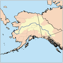 Location of the Yukon River and watershed | |
| Native name | |
| Location | |
| Countries |
|
| State | Alaska |
| Province/Territory | |
| Physical characteristics | |
| Source | Llewellyn Glacier at Atlin Lake |
| • location | Atlin District, British Columbia, Canada |
| • coordinates | 59°10′N 133°50′W |
| • elevation | 669 m (2,195 ft)[1] |
| Mouth | Bering Sea |
• location | Kusilvak, Alaska, U.S. |
• coordinates | 62°35′55″N 164°48′00″W |
• elevation | 0 m (0 ft) |
| Length | 3,190 km (1,980 mi) |
| Basin size | 833,232 km2 (321,713 sq mi) to 854,700 km2 (330,000 sq mi)[2] |
| Width | |
| • average | 0.8 km (0.50 mi) Rampart to Tanana;[3] 820 m (2,690 ft) to 1,000 m (3,300 ft) (Pilot Station)[4] |
| Depth | |
| • average | 9.1 m (30 ft)-12.1 m (40 ft) (Rampart to Tanana);[3] |
| • maximum | 40 m (130 ft) (Rampart);[3] 24.4 m (80 ft) (Pilot Station)[4] |
| Discharge | |
| • location | Pilot Station, Alaska, U.S.— (121 miles upstream of mouth; Basin size: 820,856 km2 (316,934 sq mi);[5] 831,386 km2 (321,000 sq mi)[2][6] |
| • average | (Period of data: 2001-2022) 6,840.3 m3/s (241,560 cu ft/s)[2]
(Period of data: 1971–2015) 6,576 m3/s (232,200 cu ft/s)[5] (Period of data: 1977–2006) 6,428 m3/s (227,000 cu ft/s)[7] |
| • minimum | 340 m3/s (12,000 cu ft/s) |
| • maximum | 24,600 m3/s (870,000 cu ft/s) 34,000 m3/s (1,200,000 cu ft/s) (2005)[2] |
| Discharge | |
| • location | Yukon Delta, U.S., Alaska, Bering Sea |
| • average | |
| Discharge | |
| • location | Kaltag (450 miles upstream of mouth; Basin size: 767,000 km2 (296,000 sq mi)[2] |
| • average | 6,040.2 m3/s (213,310 cu ft/s)[6] to 6,130.6 m3/s (216,500 cu ft/s)[2] |
| Discharge | |
| • location | Stevens Village (Basin size: 508,417 km2 (196,301 sq mi)[6] |
| • average | (Period of data: 1977-2022) 3,471.1 m3/s (122,580 cu ft/s)[2] |
| Discharge | |
| • location | Dawson (1,300 miles upstream of mouth; Basin size: 264,000 km2 (102,000 sq mi)[6] |
| • average | 2,160 m3/s (76,000 cu ft/s)[6] to 2,319.1 m3/s (81,900 cu ft/s)[8] |
| Basin features | |
| Tributaries | |
| • left | White River, Tanana River, Innoko River |
| • right | Tagish River, Takhini River, Teslin River, Big Salmon River, Pelly River, Stewart River, Klondike River, Birch Creek, Koyukuk River |
| [9][10] | |
The longest river in Alaska and Yukon, it was one of the principal means of transportation during the 1896–1903 Klondike Gold Rush. A portion of the river in Yukon—"The Thirty Mile" section, from Lake Laberge to the Teslin River—is a national heritage river and a unit of Klondike Gold Rush International Historical Park.[13][14] Paddle-wheel riverboats continued to ply the river until the 1950s, when the Klondike Highway was completed. After the purchase of Alaska by the United States in 1867, the Alaska Commercial Company acquired the assets of the Russian-American Company and constructed several posts at various locations on the Yukon River.
The Yukon River has a recent history of pollution from military installations, dumps, wastewater, and other sources.[15][failed verification][citation needed] However, the Environmental Protection Agency does not list the Yukon River among its impaired watersheds, and water-quality data from the U.S. Geological Survey shows relatively good levels of turbidity, metals, and dissolved oxygen.[16] The Yukon and Mackenzie rivers have much higher suspended sediment concentrations than the great Siberian Arctic rivers.[17]
The Yukon River Inter-Tribal Watershed Council, a cooperative effort of 70 First Nations and tribes in Alaska and Canada, has the goal of making the river and its tributaries safe to drink from again by supplementing and scrutinizing government data.
Name
The name Yukon, or ųųg han, is a contraction of the words in the Gwich'in phrase chųų gąįį han, which means white water river and refers to "the pale colour" of glacial runoff in the Yukon River.[18][19] The contraction is Ųųg Han, if the /ųų/ remains nasalized, or Yuk Han, if there is no vowel nasalization.[20] In the 1840s, different tribes had different opinions as to the literal meaning of Yukon. In 1843, the Holikachuks had told the Russian-American Company that their name for the river was Yukkhana and that this name meant big river.[21] However, Yukkhana does not literally correspond to a Holikachuk phrase that means big river.[22][23] Then, two years later, the Gwich'ins told the Hudson's Bay Company that their name for the river was Yukon and that the name meant white water river.[18] White water river in fact corresponds to Gwich'in words that can be shortened to form Yukon.[19] Because the Holikachuks had been trading regularly with both the Gwich’ins and the Yup'iks,[24] the Holikachuks were in a position to borrow the Gwich'in contraction and to conflate its meaning with the meaning of Kuig-pak [River-big], which is the Yup'ik name for the same river. For that reason, the documentary evidence suggests that the Holikachuks had borrowed the contraction Ųųg Han [White Water River] from Gwich'in, and erroneously assumed that this contraction had the same literal meaning as the corresponding Yup'ik name Kuig-pak [River-big].
The Lewes River is the former name of the upper course of the Yukon, from Marsh Lake to the confluence of the Pelly River at Fort Selkirk.
The following table lists the Indigenous names for the Yukon.
| Literal meaning | Native language | Spelling in the local alphabet |
Spelling in a standardized alphabet |
IPA transcription |
|---|---|---|---|---|
| 'big river' | Yup'ik | Kuigpak | Kuigpak | /kuix'pak/ |
| Inupiaq | Kuukpak | Kuukpak | /ku:k'pak/ | |
| 'white water river' | Gwich'in | Yuukan or Ųųg Han | Yuukan or Ųųk Han | /ju:kan/ /ų:k han/ |
| [citation needed] | Deg Xinag | Yeqin | Yeqin | /jəqɪn'/ |
| Holikachuk | Yooqin | Yuuqin | /ju:qɪn/ | |
| Denaakk'e | Yookkene | Yuuqene | /ju:qʰənə/ | |
| Hän | Tth’echù or Chuu k'onn | Tth'echù or Chuu k'onn | /tθʰ'etʃʰuʔ/ /tʃʰu: k'onn/ | |
| Southern Tutchone | Chu Nìikwän | Chu Nìikwen | /tʃʰu ni:kʷʰən/ |
Course
This section does not cite any sources. (September 2009) |

The generally accepted source of the Yukon River is the Llewellyn Glacier at the southern end of Atlin Lake in British Columbia. Others suggest that the source is Lake Lindeman at the northern end of the Chilkoot Trail. Either way, Atlin Lake flows into Tagish Lake (via the Atlin River), as eventually does Lake Lindeman after flowing into Bennett Lake. Tagish Lake then flows into Marsh Lake (via the Tagish River). The Yukon River proper starts at the northern end of Marsh Lake, just south of Whitehorse. Some argue that the source of the Yukon River should really be Teslin Lake and the Teslin River, which has a larger flow when it reaches the Yukon at Hootalinqua. The upper end of the Yukon River was originally known as the Lewes River until it was established that it actually was the Yukon. North of Whitehorse, the Yukon River widens into Lake Laberge, made famous by Robert W. Service's "The Cremation of Sam McGee". Other large lakes that are part of the Yukon River system include Kusawa Lake (into the Takhini River) and Kluane Lake (into the Kluane and then White River).
The river passes through the communities of Whitehorse, Carmacks, (just before the Five Finger Rapids) and Dawson City in Yukon, and crossing Alaska into Eagle, Circle, Fort Yukon, Stevens Village, Rampart, Tanana, Ruby, Galena, Nulato, Grayling, Holy Cross, Russian Mission, Marshall, Pilot Station, St. Marys (which is accessible from the Yukon at Pitkas Point), and Mountain Village. After Mountain Village, the main Yukon channel frays into many channels, sprawling across the delta. There are a number of communities after the "head of passes," as the channel division is called locally: Nunum Iqua, Alakanuk, Emmonak, and Kotlik. Of those delta communities, Emmonak is the largest with roughly 760 people in the 2000 census. Emmonak's gravel airstrip is the regional hub for flights.
Hazards

Navigational obstacles on the Yukon River are the Five Finger Rapids and Rink Rapids downstream from Carmacks.
Bridges
Despite its length, there are only four vehicle-carrying bridges across the river, listed from upstream to downstream:
- The Lewes Bridge, north of Marsh Lake, Yukon, on the Alaska Highway;
- The Robert Campbell Bridge, which connects the Whitehorse suburb of Riverdale to the downtown area;
- The Yukon River Bridge in Carmacks, Yukon, on the Klondike Highway; and
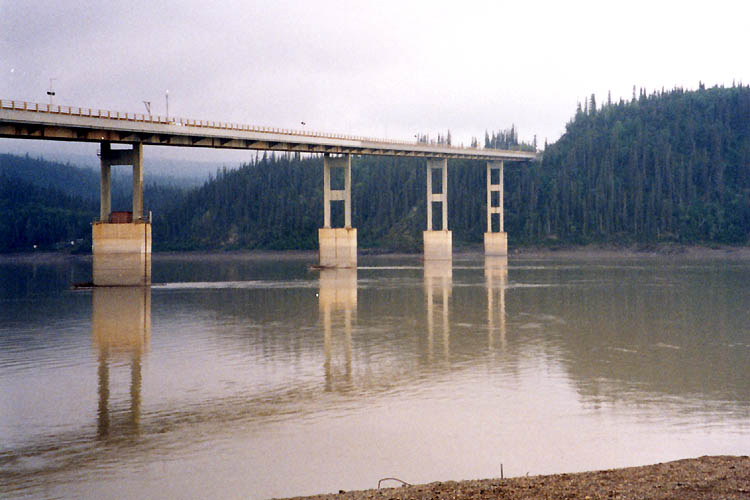
- The Yukon River Bridge, north of Fairbanks, Alaska on the Dalton Highway.
A car ferry crosses the river at Dawson City in the summer; it is replaced by an ice bridge over the frozen river during the winter. Plans to build a permanent bridge were announced in March 2004, although they are currently on hold because bids came in much higher than budgeted.
There are also two pedestrian-only bridges in Whitehorse, as well as a dam across the river and a hydroelectric generating station. The construction of the dam flooded the White Horse Rapids, which gave the city its name, and created Schwatka Lake.
Transportation is also performed along the river in summer by barge, enabling heavy goods, oil, and vehicles to be transported to communities along the Yukon, Tanana, Innoko, and Koyukuk rivers. This service is performed by Ruby Marine and reaches Tanana on the Yukon River and Nenana on the Tanana River.[25]
Geography and ecology
Some of the upper slopes of this watershed (e.g. Nulato Hills) are forested by Black Spruce.[26] This locale near the Seward Peninsula represents the near westernmost limit of the Black Spruce, Picea mariana,[27] one of the most widespread conifers in northern North America.
The river flows into several parklands and refuges including:

- Innoko National Wildlife Refuge
- Nowitna National Wildlife Refuge
- Yukon-Charley Rivers National Preserve
- Yukon Delta National Wildlife Refuge
- Yukon Flats National Wildlife Refuge
Discharge
Yukon at Pilot Station (121 miles upstream of mouth) multiannual average discharge, 1975-10-01 to 2022-09-30:
| Year | cfs | m3/s | km3 |
|---|---|---|---|
| 1976 | 218,300 | 6,182 | 195 |
| 1977 | 204,100 | 5,779 | 182 |
| 1978 | 185,300 | 5,247 | 166 |
| 1979 | 224,200 | 6,349 | 200 |
| 1980 | 236,900 | 6,708 | 212 |
| 1981 | 229,600 | 6,502 | 205 |
| 1982 | 240,800 | 6,819 | 215 |
| 1983 | 218,900 | 6,199 | 196 |
| 1984 | 231,900 | 6,567 | 207 |
| 1985 | 239,200 | 6,773 | 214 |
| 1986 | 231,400 | 6,553 | 207 |
| 1987 | 223,800 | 6,337 | 200 |
| 1988 | 218,700 | 6,193 | 195 |
| 1989 | 225,500 | 6,385 | 202 |
| 1990 | 235,400 | 6,666 | 210 |
| 1991 | 249,800 | 7,074 | 223 |
| 1992 | 239,500 | 6,782 | 214 |
| 1993 | 240,400 | 6,807 | 215 |
| 1994 | 253,700 | 7,184 | 227 |
| 1995 | 218,300 | 6,182 | 195 |
| 1996 | 209,700 | 5,938 | 187 |
| 1997 | - | - | - |
| 1998 | - | - | - |
| 1999 | - | - | - |
| 2000 | - | - | - |
| 1976 to 1996 | 227,400 | 6,439 | 203 |
| 2001 | 249,500 | 7,067 | 223 |
| 2002 | 210,400 | 5,958 | 188 |
| 2003 | 236,500 | 6,697 | 211 |
| 2004 | 211,800 | 5,998 | 189 |
| 2005 | 254,600 | 7,209 | 228 |
| 2006 | 252,300 | 7,144 | 226 |
| 2007 | 213,600 | 6,048 | 191 |
| 2008 | 231,600 | 6,558 | 207 |
| 2009 | 231,900 | 6,567 | 207 |
| 2010 | 205,600 | 5,822 | 184 |
| 2011 | 227,000 | 6,428 | 203 |
| 2012 | 247,700 | 7,014 | 221 |
| 2013 | 231,700 | 6,561 | 207 |
| 2014 | 266,400 | 7,544 | 238 |
| 2015 | 229,400 | 6,499 | 205 |
| 2016 | 274,600 | 7,776 | 245 |
| 2017 | 214,900 | 6,085 | 192 |
| 2018 | 257,600 | 7,294 | 230 |
| 2019 | 233,300 | 6,606 | 208 |
| 2020 | 290,900 | 8,237 | 260 |
| 2021 | 262,200 | 7,425 | 234 |
| 2022 | 280,800 | 7,952 | 251 |
| 2001 to 2022 | 241,600 | 6,840 | 216 |
| 1976 to 2022 | 232,750 | 6,591 | 208 |
Fisheries
The Yukon River is home to one of the longest salmon runs in the world. Each year Chinook, coho, and chum salmon return to their terminal streams in Alaska, the Yukon Territory, and British Columbia. The Chinook have the longest journey, with an estimated 35–50% bound for Canada. As salmon do not eat during their spawning migration, Yukon River salmon must have great reserves of fat and energy to fuel their thousands-mile-long journey. As a result, Yukon River salmon are noted for their especially rich and oily meat.
The villages along the Yukon have historically relied on and continue to rely on salmon for their cultural, subsistence, and commercial needs. Salmon are traditionally dried, smoked, and frozen for both human and sled dog consumption. Common methods of fishing on the Yukon include set gillnets, drift nets, dip nets, and fish wheels. The preference of certain gear is largely dependent on the river's varied characteristics in different areas. Some parts of the river do not have eddies to make set-nets successful, whereas in other places the tributaries are small enough to make drifting impractical.
Over the last 20 years salmon recruitment, the number of returning adults, has taken several shocks. The late 1980s, 1990s, and 2000s have been marked by radically reduced runs for various salmon species. The United States Department of Commerce issued a Federal Disaster Declaration for the 2008 and 2009 Commercial Chinook Yukon River fisheries, calling for the complete closure of commercial fishing along with restrictions on subsistence fishing. The root cause of these poor returns remains debated, with questions about the effects of climate change on ocean food-supply & disease prevalence in returning adults, the methods of fishing used on the river, and the effects of the Bering Sea Pollock trawl fleet on food supply and salmon bycatch.[28][29] In 2010, the Alaska Department of Fish & Game's Board of Fisheries issued the first-ever restriction for net mesh size on the Yukon, reducing it to 7.5 inches (190 mm).[30]
Various organizations are involved to protect healthy salmon runs into the future. The Yukon River Drainage Fisheries Association was formed in 1990 by a consensus of fishers representing the entire drainage in response to recent disaster years. Its organizational goals include giving voice to the village fishers that have traditionally managed these resources, enabling communication between fishers and fishery managers, and helping to preserve the ecological integrity of salmon runs and local cultures' Traditional Ecological Knowledge[31]
In March 2001, the U.S. & Canadian governments passed the Yukon River Salmon Agreement to better manage an internationally shared resource and ensure that more Canadian-originated salmon return across the border.[32] The agreement is implemented through the Yukon River Panel, an international body of 12 members, equal-parts American and Canadian, that advises managers of Yukon River fisheries concerning restoration, conservation, and coordinated management.[33]
Tribal organizations such as the Association of Village Council Presidents (AVCP), Council of Athabascan Tribal Governments (CATG), and Tanana Chiefs Conference (TCC) work to sustain Yukon River salmon to promote healthy people, cultures, and communities.
Tributaries

This section's use of red links may not follow Wikipedia's guidelines. (June 2022) |
Yukon Territory

- Takhini River
- Big Salmon River
- Little Salmon River (Yukon)
- Nordenskiold River
- Teslin River
- Pelly River
- Stewart River
- Nadaleen River
- Lansing River
- Hess River
- Mayo River
- McQuesten River
- White River
- Donjek River
- Kluane River
- Nisling River
- Beaver Creek
- Donjek River
- Sixtymile River
- Indian River
- Klondike River
- Fortymile River
Alaska
- Tatonduk River
- Seventymile River
- Nation River
- Kandik River
- Charley River
- Porcupine River
- (tributaries in the Yukon)
- Miner tributaries
- Bell River
- Eagle River
- Rock River (Yukon)
- Driftwood River (Yukon)
- Old Crow River
- Bluefish River
- (tributaries in Alaska)
- Coleen River
- Black River
- Wood River
- Bear Mountain Creek
- Mountain Creek
- Chandalar Creek
- Sheenjek River
- Sheenjek River East Fork
- Koness River
- Eskimo Creek
- Christian River
- Chandalar River
- East Fork Chandalar River
- Junjik River
- Wind River
- Middle Fork Chandalar River
- North Fork Chandalar River
- West Fork Chandalar River
- Marten Creek
- East Fork Chandalar River
- Birch Creek
- Hadweenzic River
- Beaver Creek
- Hodzana River
- Dall River
- Ray River
- Big Salt River
- Hess Creek
- Garnet Creek
- Fish Creek
- Texas Creek
- Coal Creek
- Tanana River
- Nabesna River
- Chisana River
- Tetlin River
- Goodpaster River
- Delta River
- Salcha River
- Chena River
- Wood River
- Nenana River
- Tolovana River
- Kantishna River
- NC Creek
- Tozitna River
- Bluebell Creek
- Dagislakhna Creek
- Banddana Creek
- Blind River
- Bering Creek
- Nowitna River
- Sulatna River
- Big Creek
- Beaver Creek
- Glacier Creek
- Melozitna River
- Black Sand Creek
- Little Melozitna River
- Ruby Slough
- Yuki River
- East Fork Yuki River
- Kala Creek
- Kelly Creek
- Galena Creek
- Bishop Creek

- Koyukuk River
- Workyard Creek
- Gisasa River
- Kateel River
- Dulbi River
- Huslia River
- Nulitna River
- Tom Cook Slough
- Billy Hawk Creek
- Cutoff Slough
- Hogatza River
- Clear Creek
- Batza River
- Matthews Slough
- Little Indian River
- Indian River
- Calamity Creek
- Pocahontas Creek
- Kanuti River
- Discovery Creek
- Alatna River
- Siruk Creek
- South Fork Koyokouk River
- Jim River
- Jane Creek
- John River
- North Fork Koyukuk River
- Nulato River
- Khotol River
- Anvik River
- Bonasila River
- Stuyahok River
- Innoko River
- Paimiut Slough
- Reindeer River
- Iditarod River
- Yetna River
- First Chance Creek
- Mud River
- Dishna River
- Coffee Creek
- Tolstoi Creek
- Madison Creek
- Mastodon Creek
- Hurst Creek
- Taft Creek
- Finland Creek
- Scandinavian Creek
- North Fork Innoko River
- Tango Creek
- West Fork North Fork Innoko River
- Colorado Creek
- Paimiut Slough
- Kako Creek
- Engineer Creek
- Reindeer River
- Atchuelinguk River
- Andreafsky River
- Kashunuk River (distributary)
List of major tributaries
The main river and tributaries are (sorted in order from the mouth heading upstream):
| Left
tributary | Right
tributary | Length
(km) | Basin size
(km²) | Average discharge
(m3/s) |
|---|---|---|---|---|
| Nanvaranak Slough | 1,735 | 28.1 | ||
| Archuelinguk | 705 | 12.8 | ||
| Andreafsky | 193 | 5,369 | 91.4 | |
| Kashunuk
(distributary) | 362 | 2,906 | 51.7 | |
| Atchuelinguk | 266 | 5,439 | 73.8 | |
| Reindeer | 97 | 1,191 | 22 | |
| Talbiksok | 1,857 | 26.5 | ||
| Kako Creek | 550 | 9.8 | ||
| Innoko | 805 | 36,517 | 335.5 | |
| Koserefski | 897 | 13.1 | ||
| Bonasila | 201 | 3,108 | 43.7 | |
| Anvik | 225 | 4,610 | 65 | |
| Khotol | 137 | 2,331 | 40.1 | |
| Nulato | 114 | 2,287 | 54.2 | |
| Koyukuk | 805 | 81,326 | 770 | |
| Bear Creek | 789 | 10.8 | ||
| Kala Creek | 893 | 13 | ||
| Yuki | 137 | 2,771 | 33.4 | |
| Melozitna | 217 | 7,045 | 67.6 | |
| Big Creek | 814 | 4.6 | ||
| Nowitna | 455 | 18,596 | 102.4 | |
| Blind | 587 | 3.4 | ||
| Boney Creek | 788 | 3.9 | ||
| Tozitna | 134 | 4,248 | 28.2 | |
| Tanana | 1,061 | 113,959 | 1,246 | |
| Hess Creek | 80 | 3,082 | 15.6 | |
| Ray | 69 | 1,751 | 14.2 | |
| Dall | 129 | 3,714 | 17.6 | |
| Old Lost Creek | 10.3 | |||
| Hodzana | 201 | 4,323 | 19.5 | |
| Beaver Creek | 290 | 5,426 | 54.9 | |
| Hadweenzic | 150 | 2,422 | 19.4 | |
| Birch Creek | 241 | 13,064 | 127 | |
| Chandalar | 328 | 24,165 | 141.8 | |
| Christian | 225 | 8,827 | 67.8 | |
| Porcupine | 916 | 116,431 | 623 | |
| Charley | 142 | 4,377 | 22.7 | |
| Kandik | 132 | 2,840 | 19.7 | |
| Nation | 113 | 2,411 | 24.6 | |
| Tatonduk | 110 | 15.6 | ||
| Seventymile | 93 | 7.5 | ||
| Fortymile | 97 | 16,602 | 79.4 | |
| Klondike | 161 | 8,044 | 63.9 | |
| Indian | 2,242 | 20.4 | ||
| Sixtymile | 137 | 3,719 | 25.4 | |
| Stewart | 533 | 51,023 | 510 | |
| White | 322 | 46,900 | 566 | |
| Pelly | 608 | 48,174 | 412 | |
| Nordenskiöld | 6,371 | 16 | ||
| Little Salmon | 3,626 | 9.7 | ||
| Big Salmon | 240 | 6,760 | 67.6 | |
| Teslin | 393 | 35,014 | 331 | |
| Takhini | 180 | 6,993 | 103.1 | |
| Atlin | 6,812 | 110 |
In media
- The Yukon River features as the setting for the 2015 National Geographic Channel series Yukon River Run.[34]
- The industrial metal band Lindemann wrote a song named "Yukon" on their first album Skills in Pills.
See also
- Alaska salmon fishery
- List of longest rivers of Canada
- List of longest rivers of the United States (by main stem)
- List of rivers of Alaska
- List of Yukon rivers
- Steamboats of the Yukon River
References
- "Atlin Lake". Peakbagger.com. Retrieved 11 October 2020.
- "USGS".
- "Yukon River Panel".
- "Yukon (Pilot) River".
- Stadnyk, Tricia A.; Tefs, A.; Broesky, M.; Déry, S. J.; Myers, P. G.; Ridenour, N. A.; Koenig, K.; Vonderbank, L.; Gustafsson, D. (2021). "Changing freshwater contributions to the Arctic". Elementa: Science of the Anthropocene. 9. doi:10.1525/elementa.2020.00098. S2CID 236682638.
- "GRDC".
- "River Discharge". Arctic.noaa.gov. Retrieved 11 June 2022.
- "Rivers Network".
- Brabets, Timothy P; Wang, Bronwen; Meade, Robert H. (2000). "Environmental and Hydrologic Overview of the Yukon River Basin, Alaska and Canada" (PDF). United States Geological Survey. Retrieved 5 March 2010.
- Yukon River at the Encyclopædia Britannica
- "Yukoninfo.com". Yukoninfo.com. Retrieved 2013-08-18.
- Walvoord, Michelle A.; Striegl, Robert G. (2007-06-28). "Increased groundwater to stream discharge from permafrost thawing in the Yukon River basin: Potential impacts on lateral export of carbon and nitrogen". Geophysical Research Letters. 34 (12): L12402. doi:10.1029/2007GL030216. ISSN 0094-8276.
- The Thirty Mile (Yukon River) National Heritage River Archived January 6, 2011, at the Wayback Machine, National Heritage Rivers System
- Klondike Gold Rush International Historical Park Archived October 9, 2012, at the Wayback Machine, Parks Canada
- "Earth Snapshot • Yukon River". Eosnap.com. Retrieved 2018-02-09.
- "USGS Water Quality Samples – 1 sites found". Nwis.waterdata.usgs.gov. Retrieved 2013-08-18.
- "Arctic Great Rivers Observatory". Arctic Great Rivers. Retrieved 2018-04-10.
- "Dear Sir, I have great pleasure in informing you that I have at length after much trouble and difficulties, succeed[ed] in reaching the 'Youcon', or white water River, so named by the (Gwich'in) natives from the pale colour of its water. ..., I have the honour to Remain Your obt Servt, John Bell" Hudson's Bay Company Correspondence to George Simpson from John Bell (August 1, 1845), HBC Archives, D.5/14, fos. 212-215d, also quoted in, Coates, Kenneth S. & William R. Morrison (1988). Land of the Midnight Sun: A History of the Yukon. Hurtig Publishers. p. 21. ISBN 0-88830-331-9. Retrieved 2017-10-16.
- In Gwich'in, adjectives, such as choo [big] and gąįį [white], follow the nouns that they modify. Thus, white water is chųų gąįį [water white]. White water river is chųų gąįį han [water white river]. Peter, Katherine (1979). Dinjii Zhuh Ginjik Nagwan Tr'iłtsąįį: Gwich'in Junior Dictionary (PDF). Univ. of Alaska. pp. ii (ą, į, ų are nasalized a, i, u), xii (adjectives follow nouns), 19 (nitsii or choo [big]), 88 (ocean = chųų choo [water big]), 105 (han [river]), 142 (chųų [water]), 144 (gąįį [white]). Retrieved 2017-10-16.
- Gwich'in vowels may or may not be nasalized. A hook under a vowel, as in "ų," indicates that the vowel is nasalized. Peter (1979). Dinjii Zhuh Ginjik Nagwan Tr'iłtsąįį., at page ii (footnote). English, of course, has no nasalized vowels.
- "[The Yukon] in the language of the Kang-ulit (Yup'ik) people is Kvikhpak; in the dialect of the downriver Inkilik (Holikachuk), Yukkhana; of those upriver (Koyukon), Yuna. All these terms mean the same thing in translation–'Big River.' I have kept the local names as a clearer indication of the different tribes along the river." Lt. Zagoskin's Note 63 (1848), translated in, Zagoskin, Lavrenty A.; Henry N. Michael, eds. (1967). Lieutenant Zagoskin's Travels in Russian America, 1842-1844: The First Ethnographic and Geographic Investigations in the Yukon and Kuskokwim Valleys of Alaska. University of Toronto Press., at page 295. Zagoskin did not come into contact with the Gwich'in Indians and had no access to the information that Yukon means white water river in Gwich'in – the language from which the word came.
- In Holikachuk, big river or big water would be xinmiksekh, xinchux, toomiksekh, or toochux. Kari, James; et al. (1978). Holikachuk Noun Dictionary (PDF). Univ. of Alaska Fairbanks. p. 19 (xin [river], too [water]). Retrieved 2017-10-16.; Zagoskin; Michael (1967). Lieutenant Zagoskin's Travels., at page 309 (Inkilik proper [Holikachuk] tu [water], miksekh [large]); Hargus, Sharon (2008). Vowel quality and duration in Deg Xinag (PDF). Univ. of Washington. p. 29 (note 33: Holikachuk chux [big]). Retrieved 2017-10-16. Adjectives followed the nouns that they modified in Holikachuk.
- Thirty-nine pages of cited "Sources," representing over a century of research, did not verify Zagoskin's report that Yukon means big river. Orth (1967). Dictionary of Alaska Place Names., at pp. 6-44 ("Sources of Names"), 1069 ("The Eskimo ... descriptively called it 'Kuikpak' meaning 'big river.' The Indian name 'Yukon' probably means the same thing."). Orth does not say "probably" when discussing Kuikpak's meaning. Orth's use of "probably" is limited to the discussion of Yukon's meaning, which indicates that Zagoskin's report that Yukon means big river was never verified. In addition, Orth's "Sources" do not even include the Hudson's Bay Company correspondence, which states that Yukon means white water river in Gwich'in. Nor do Orth's "Sources" include aboriginal dictionaries.
- Lt. Zagoskin reported that: "The ... Inkilit [Holikachuk] ... live along the routes of communication between the Yukon and the coast and are occupied almost exclusively with buying up furs from the natives living along the Yunnaka (Koyukuk River, a Yukon tributary)." Zagoskin also reported that: "The Inkalik [Holikachuk] ..., who are chiefly occupied in trading both with their fellow tribesmen and with the neighboring tribes of Kang-ulit (Yup'ik), have adopted the way of life of the latter ..." Zagoskin; Michael (1967). Lieutenant Zagoskin's Travels., at pp. 196-97, 244. Because they had adopted the Yup’ik (Eskimo) way of life, and because they were the ones trading upriver, the Holikachuk would have been "the Esquimaux" referred to in John Bell's 1845 report: "The Esquimaux to the westwards likewise ascends the 'Youcon' and carry on a trade with the natives, as well as with the Musquash [Gwich'in] Indians ... I have seen a large camp of the latter tribe on the Rat River on my return, who, had about a doz: of beat [hammered] Iron Kettles of Russian Manufacture which they bartered from the Esquimaux." See, Hudson's Bay Company Correspondence to Simpson from Bell (1845), HBC Archives, D.5/14, fos. 212, 213. For these reasons, the Holikachuk were in a position to conflate the meanings of the Gwich'in and Yup'ik names, and to furnish this conflated information to the Russian-American Company.
- "Ruby Marine". Rubymarineinc.com. Retrieved 11 June 2022.
- Scott R. Robinson. 1988. Movement and Distribution of Western Arctic Caribou Herd across the Buckland Valley and Nulato Hills, U.S. Bureau of Land Management Open file Report 23, Alaska
- C. Michael Hogan, Black Spruce: Picea mariana, GlobalTwitcher.com, ed. Nicklas Stromberg, November, 2008 Archived October 5, 2011, at the Wayback Machine
- Thiessen, Mark. Feds declare fisheries disaster for Yukon River Archived December 6, 2010, at the Wayback Machine. Fairbanks Daily News-Miner. Retrieved 15 March 2010
- Hopkins, Kyle. Pollock vs. salmon bycatch issue stirs waters at meeting Archived June 10, 2011, at the Wayback Machine. Anchorage Daily News. Retrieved 15 March 2010
- Associated Press. Fisheries board restricts Yukon salmon gillnets Archived March 9, 2010, at the Wayback Machine. Anchorage Daily News. Retrieved 15 March 2010
- Sea Grant Alaska. Yukon Fishermen Celebrate Ten Years. Arctic Science Journeys. Retrieved 15 March 2010
- Yukon River Salmon Agreement. Yukonriverpanel.com, March 2001
- Bylaws of the Yukon River Panel Society. Yukonriverpanel.com, November 2002
- Alcinii, Daniele (June 26, 2015). "Nat Geo sets summer premieres for adventure series". Real Screen. Retrieved August 31, 2015.
External links
- Arctic Great Rivers Observatory
- Canadian Council for Geographic Education page with a series of articles on the history of the Yukon River
- The Yukon River Bridge at Dawson City
- Yukon River Inter-Tribal Watershed Council
- Yukon River Drainage Fisheries Association
- Yukon River Panel
Canadian Heritage Rivers System | |
|---|---|
| Rivers |
|
| Nominated | |
| |
Authority control | |
|---|---|
| General |
|
| National libraries | |
| Other | |
На других языках
[de] Yukon River
Der Yukon River (französisch Fleuve Yukon) ist ein Strom, der in der kanadischen Provinz British Columbia entspringt und danach das nach ihm benannte Territorium Yukon durchfließt, bevor er im US-Bundesstaat Alaska in das Beringmeer mündet.- [en] Yukon River
[it] Yukon (fiume)
Lo Yukon (AFI: [ˈjukon][1]) è un fiume artico del Nordamerica. Nasce nell'omonimo territorio canadese, attraversa l'Alaska e sfocia nel Mare di Bering. Ha una lunghezza complessiva di 3.185 km e un bacino idrografico di 839.200 km². Il fiume fu teatro della corsa all'oro dell'Ottocento.[ru] Юкон (река)
Ю́кон[1] (англ. Yukon River) — река на северо-западе Северной Америки, протекающая в основном по территории Юкон (Канада) и штату Аляска (США). Впадает в залив Нортон Берингова моря, формируя многорукавную дельту.Другой контент может иметь иную лицензию. Перед использованием материалов сайта WikiSort.org внимательно изучите правила лицензирования конкретных элементов наполнения сайта.
WikiSort.org - проект по пересортировке и дополнению контента Википедии