geo.wikisort.org - River
The longest rivers of the United States include 38 that have main stems of at least 500 miles (800 km) long. The main stem is "the primary downstream segment of a river, as contrasted to its tributaries".[1] The United States Geological Survey (USGS) defines a main-stem segment by listing coordinates for its two end points, called the source and the mouth. Some well-known rivers like the Atchafalaya,[2] Willamette,[3] and Susquehanna[4] are not included in this list because their main stems are shorter than 500 miles.

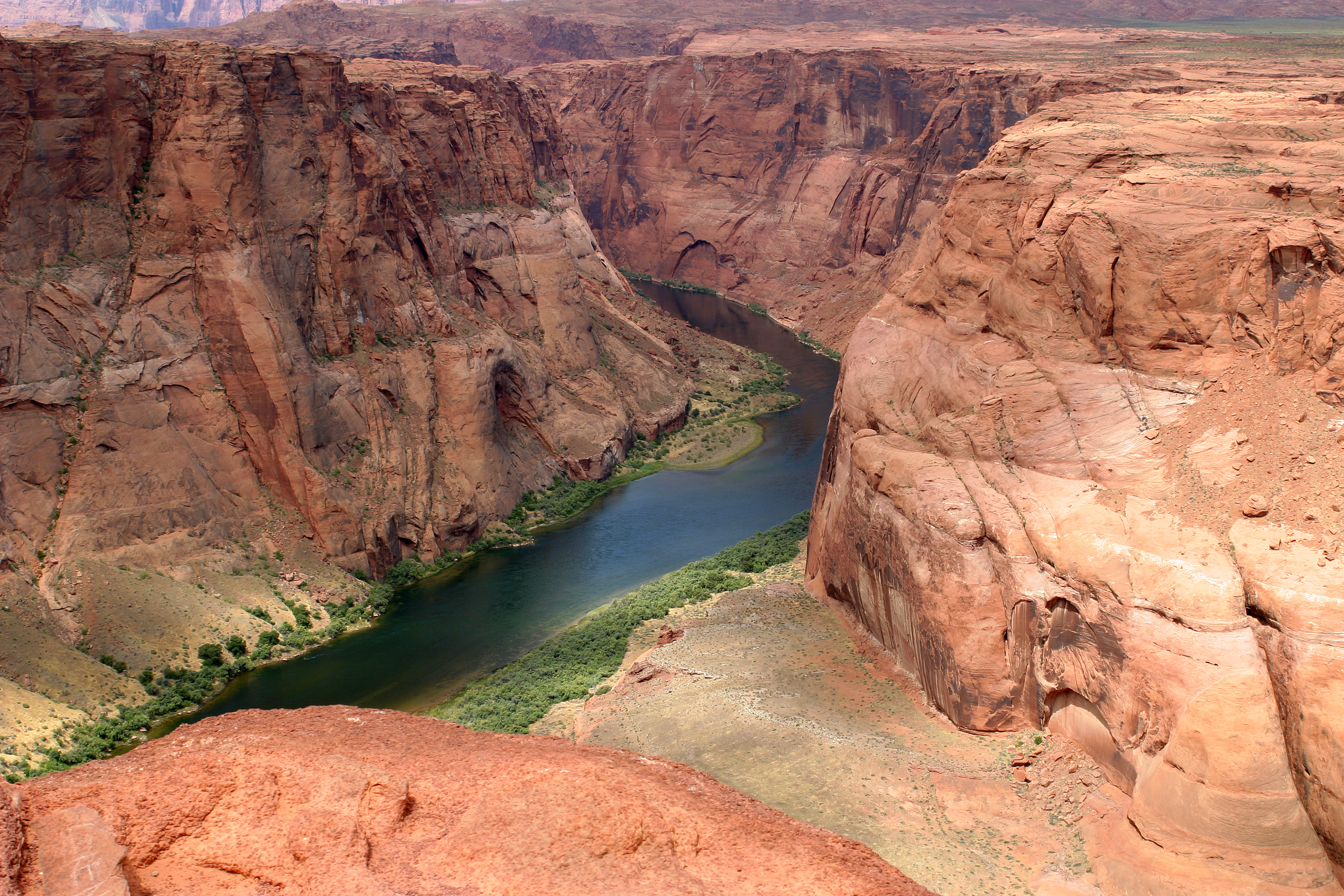
Seven rivers in this list cross or form international boundaries. Two—the Yukon and Columbia rivers—begin in Canada and flow into the United States. Three—the Milk and Saint Lawrence rivers and the Red River of the North—begin in the United States and flow into Canada. Of these, only the Milk River crosses the international border twice, leaving and then re-entering the United States.[5] Two rivers, the Colorado and the Rio Grande, begin in the United States and flow into or form a border with Mexico.[5] In addition, the drainage basins of the Mississippi and Missouri rivers extend into Canada,[6][7] and the basin of the Gila River extends into Mexico.[8]
Sources report hydrological quantities with varied precision. Biologist and author Ruth Patrick, describing a table of high-discharge U.S. rivers, wrote that data on discharge, drainage area, and length varied widely among authors whose works she consulted. "It seems," she said, "that the wisest course is to regard data tables such as the present one as showing the general ranks of rivers, and not to place too much importance on minor (10–20%) differences in figures."[9]
Table
The primary source for watershed and discharge data in the table below is Rivers of North America. Conflicting data from other sources, if the difference is greater than 10 percent, is reported in the notes. Discharge refers to the flow at the mouth.[n 1] In the "States, provinces, and image" column, the superscripts "s" and "m" indicate "source" and "mouth". Non-U.S. states appear in italics. Except in the "States, provinces, and image" column, abbreviations are as follows: "km" for "kilometer", "mi" for "mile", "s" for "second", "m" for "meter", and "ft" for "foot".
| Key | |||||
|---|---|---|---|---|---|


Map

See also
- List of longest rivers in the United States by state
- List of rivers by length
Notes
- Dams, diversions for agriculture, and other human alterations to rivers have greatly affected the discharge of some rivers over time. For example, the virgin discharge of the Colorado River is estimated to have been 20,000 ft3/s (566 m3/s) compared to 1,400 ft3/s (~40 m3/s) in 2005.[10]
- Of the total, 10,700 mi2 (28,000 km2), about two percent of the basin, is in Canada.[6][7]
- Kammerer: 76,200 ft3/s (2,160 m3/s).[16]
- Kammerer: 2,340 mi (3,770 km).[16] The Atlas of Canada: 2,348 mi (3,779 km).[6]
- Of the total, 10,700 mi2 (27,800 km2), less than one percent of the basin, is in Canada.[6][7]
- Of this total, 714 mi (1,149 km) are in Canada. This amounts to about 36 percent of the main-stem length.[6]
- The Atlas of Canada also lists the total basin size at 324,000 mi2 (839,200 km2), split between 125,000 mi2 (323,800 km2), about 39 percent, in Canada and 199,000 mi2 (515,400 km2), about 61 percent, in the United States.[6]
- Kammerer: 1,900 mi (3,100 km).[16] University of Texas (UT): 1,799 mi (2,895 km).[24] The river forms the U.S.–Mexico border for 1.251 mi (2,013 km) (about 70 percent of its main-stem length) from El Paso to the Gulf of Mexico.[24]
- Rivers of North America says that of this total only about 170,000 mi2 (450,000 km2) of the basin contribute water to the river.[26] The University of Texas (UT) says, "The river collects rain, snowmelt and spring water from an area [of] about 215,338 mi2 [557,722 km2] including closed basins."[24] It says that 87,020 mi2 (225,380 km2) of the basin (about 48 percent), not counting closed basins, are in Mexico, while 93,821 mi2 (242,994 km2) (about 52 percent) are in the United States.[24] Kammerer cites a total basin size of 336,000 mi2 (870,000 km2).[16]
- According to the Utah Division of Water Resources, 75 mi (121 km) of the river are in Mexico. This amounts to about 5 percent of the main-stem length.[27] Of this, 17 mi (27 km) form the border between Mexico and the United States.[28]
- The United Nations Environment Programme cites a total basin size of 246,000 mi2 (637,000 km2), split between 2,000 mi2 (5,200 km2) (about 1 percent) in Mexico and 244,000 mi2 (632,000 km2) (about 99 percent) in the United States.[28]
- Derived by subtracting the length of the East Fork Arkansas River of roughly 16 mi (26 km)[31] from Kammerer's total of 1,459 mi (2,348 km).[16]
- About 498 mi (801 km) are in Canada.[6] This amounts to about 40 percent of the main-stem length.
- The Atlas of Canada lists the total watershed at 259,200 mi2 (671,300 km2), split between 39,700 mi2 (102,800 km2) (about 15 percent) in Canada and 219,500 mi2 (568,500 km2) (about 85 percent) in the United States.[6] Kammerer's figure for the total watershed is 265,000 mi2 (690,000 km2).[16]
- This is the combined length, 1,360 mi (2,190 km),[37] of the main stem, Prairie Dog Town Fork Red River, and Tierra Blanca Creek minus the lengths of the latter two, 160 mi (260 km)[38] and 75 mi (121 km).[39] Kammerer gives the length as 1,290 mi (2,080 km).[16]
- Kammerer: 93,200 mi2.[16]
- Kammerer: 56,000 ft3/s (1,600 m3)[16]
- Also known as the Dakota River or Jim River and not to be confused with the James River of Virginia.
- This is the average discharge for the years 1982–94, derived by adding the discharge for each of these years and dividing by 13.
- According to The Canadian Encyclopedia, a 110-mi (170 km) stretch of the river flows through Canada. This amounts to about 18 percent of the main-stem length.[84]
- The Atlas of Canada: 23,600 mi2 (61,200 km2) split between 8,300 mi2 (21,600 km2) (about 35 percent) in Canada and 15,300 mi2 (39,600 km2) (about 65 percent) in the United States.[6]
- According to the U.S. Army Corps of Engineers, a 115-mi (185 km) stretch of the river forms part of the U.S.–Canada border. This amounts to about 19 percent of the main-stem length.[91]
- Kammerer: 396,000 mi2 (1,030,000 km2).[16] The Atlas of Canada: 519,000 mi2 (1,344,200 km2), of which 324,000 mi2 (839,200 km2) (about 62 percent) is in Canada and 195,000 mi2 (505,000 km2) (about 38 percent) is in the United States.[6]
- Kammerer: 348,000 ft3/s (9,900 m3/s).[16]
- Of this total, 232 mi2 (600 km2) (about 0.4 percent) are in the Mexican state of Sonora, and the rest is in the United States.[8]
- Rivers of North America describes the discharge as less than 210 ft3/s (6 m3/s.
- This is the size of the basin upstream of a stream gauge near Kindred and at river mile 67.9 (river kilometer 109.3).[100]
- This is the average flow measured by a stream gauge near Kindred and at river mile 67.9 (river kilometer 109.3).[100]
- The main-stem length is calculated by subtracting the length of the Nabesna River from Kammerer's total of 659 mi (1,061 km).[16] The Nabesna River is roughly 75 mi (121 km) long, calculated by adding the 60 mi (97 km) from the Nabesna mouth to Camp Creek[101] to the distance, 15 mi (24 km), from Camp Creek to Nabesna Glacier,[102] Kammerer's most remote source for the Tanana.
- Reflects only that part of the basin above a stream gauge at river mile 43.3 (river kilometer 69.7) near Enterprise.[106]
- Measured by a stream gauge at river mile 43.3 (river kilometer 69.7) near Enterprise.[106]
- This is only a close approximation of the entire basin. It does not include a small fraction of the basin below the river gauge, located about 25 mi (40 km) upstream of the river mouth.
- This is the average discharge for the years 1990–2010, derived by adding the discharge for each of these years and dividing by 21.
- According to the Minnesota Department of Natural Resources, 394 mi (634 km) are in the United States. This amounts to about 72 percent of the main-stem length.[116]
- Of the total basin, 53,500 mi2 (138,600 km2) (about 48 percent) are in Canada and 57,500 mi2 (148,900 km2) (about 52 percent) are in the United States.[6]
References
- Benke & Cushing 2005, p. 1137.
- Benke & Cushing 2005, p. 236.
- Benke & Cushing 2005, p. 615.
- Benke & Cushing 2005, p. 50.
- The Road Atlas. Chicago, Illinois: Rand McNally & Company. 2008. ISBN 978-0-528-93961-7.
- "Rivers". The Atlas of Canada. Natural Resources Canada. Archived from the original on April 4, 2007. Retrieved February 11, 2011.
- "Missouri River Basin Basic Geography and Natural Features". United States Geological Survey. Archived from the original on April 7, 2014. Retrieved February 20, 2011.
- McCord, Marc W. "Gila River". Wind Spirit Community. Archived from the original on March 3, 2017. Retrieved February 20, 2011.
- Patrick 1995, p. 24.
- Benke & Cushing 2005, p. 527.
- The mouth coordinates and source coordinates are from the Geographic Names Information System (United States Geological Survey) or the Canadian Geographical Names Data Base except for the coordinates of the mouth of the Colorado River, derived by geolocating with Google Earth.
- From Rivers of North America (ed. Benke and Cushing) unless otherwise noted.
- Benke & Cushing 2005, p. 432.
- "Missouri River". Geographic Names Information System (GNIS). United States Geological Survey. October 24, 1980. Retrieved February 4, 2011.
- Benke & Cushing 2005, p. 469.
- Kammerer, J. C. (September 1, 2005). "Largest Rivers in the United States". United States Geological Survey. Retrieved January 22, 2011.
- Benke & Cushing 2005, pp. 237, 331.
- "Mississippi River". Geographic Names Information System (GNIS). United States Geological Survey. June 4, 1980. Retrieved February 4, 2011.
- Benke & Cushing 2005, p. 272.
- "Atlin Lake (B.C.)". Natural Resources Canada. Archived from the original on July 6, 2011. Retrieved February 4, 2011.
- "Yukon River". Geographic Names Information System (GNIS). United States Geological Survey. March 31, 1981. Retrieved February 4, 2011.
- Benke & Cushing 2005, p. 796.
- Benke & Cushing 2005, p. 186.
- Patino, Carlos; McKinney, Daene C.; Maidment, David R. "Water Management Information System for the Rio Grande/Bravo Basin". University of Texas Center for Research in Water Resources. Archived from the original on April 1, 2015. Retrieved February 19, 2011.
- "Rio Grande". Geographic Names Information System (GNIS). United States Geological Survey. March 30, 1979. Retrieved February 4, 2011.
- Benke & Cushing 2005, p. 220.
- Anderson, D. Larry (May 2002). "Utah's Perspective: The Colorado River" (PDF). p. 5. Archived from the original (PDF) on April 9, 2014. Retrieved February 19, 2011.
- Arias, E.; Albar, M.; Parra, I; Reza, M. "Regional Definition" (PDF). United Nations Environment Programme. pp. 20–21. Archived from the original (PDF) on May 31, 2017. Retrieved May 30, 2017.
- "Colorado River". Geographic Names Information System (GNIS). United States Geological Survey. February 8, 1980. Retrieved February 4, 2011.
- Derived via Google Earth
- Colorado Atlas and Gazetteer (Map). DeLorme. 1998. § 47–48. ISBN 978-0-89933-265-9.
- "Arkansas River". Geographic Names Information System (GNIS). United States Geological Survey. November 30, 1979. Retrieved February 4, 2011.
- Benke & Cushing 2005, p. 315.
- "Columbia Lake". Natural Resources Canada. Archived from the original on July 6, 2011. Retrieved January 31, 2011.
- "Columbia River". Geographic Names Information System. United States Geological Survey. November 28, 1980. Retrieved August 5, 2010.
- Benke & Cushing 2005, p. 646.
- Kleiner, Diana J. "Handbook of Texas: Red River". Texas State Historical Association. Archived from the original on December 23, 2015. Retrieved February 18, 2011.
- "Handbook of Texas: Prairie Dog Town Fork of the Red River". Texas State Historical Association. Archived from the original on March 14, 2016. Retrieved February 18, 2011.
- "Handbook of Texas: Tierra Blanca Creek". Texas State Historical Association. Retrieved February 18, 2011.
- "Red River". Geographic Names Information System (GNIS). United States Geological Survey. June 4, 1980. Retrieved February 5, 2011.
- Benke & Cushing 2005, p. 317.
- "Snake River". Geographic Names Information System (GNIS). United States Geological Survey. September 10, 1979. Retrieved August 6, 2010.
- Benke & Cushing 2005, p. 643.
- Benke & Cushing 2005, p. 379.
- "Ohio River". Geographic Names Information System (GNIS). United States Geological Survey. October 24, 1980. Retrieved February 5, 2011.
- Benke & Cushing 2005, p. 413.
- Benke & Cushing 2005, p. 198.
- "Colorado River". Geographic Names Information System (GNIS). United States Geological Survey. November 30, 1979. Retrieved February 5, 2011.
- Benke & Cushing 2005, p. 222.
- Benke & Cushing 2005, p. 384.
- "Tennessee River". Geographic Names Information System (GNIS). United States Geological Survey. September 20, 1979. Retrieved February 5, 2011.
- Benke & Cushing 2005, p. 414.
- "Canadian River". Geographic Names Information System (GNIS). United States Geological Survey. December 18, 1979. Retrieved February 5, 2011.
- Benke & Cushing 2005, p. 316.
- Benke & Cushing 2005, p. 203.
- "Brazos River". Geographic Names Information System (GNIS). United States Geological Survey. November 30, 1979. Retrieved February 5, 2011.
- Benke & Cushing 2005, p. 223.
- Benke & Cushing 2005, p. 497.
- "Green River". Geographic Names Information System. United States Geological Survey (USGS). December 31, 1979. Retrieved February 5, 2011.
- Benke & Cushing 2005, p. 528.
- Benke & Cushing 2005, p. 213.
- "Pecos River". Geographic Names Information System. United States Geological Survey (USGS). November 30, 1979. Retrieved February 5, 2011.
- Benke & Cushing 2005, p. 225.
- Benke & Cushing 2005, p. 246.
- "White River". Geographic Names Information System. United States Geological Survey (USGS). April 30, 1980. Retrieved February 5, 2011.
- Benke & Cushing 2005, p. 273.
- "River Facts". American Rivers. Archived from the original on March 10, 2012. Retrieved February 22, 2011.
- "James River". Geographic Names Information System. United States Geological Survey (USGS). February 13, 1980. Retrieved February 22, 2011.
- "USGS 06478513 James River near Yankton, SD". United States Geological Survey. November 2010. Retrieved February 23, 2011.
- Benke & Cushing 2005, p. 741.
- "Kuskokwim River". Geographic Names Information System. United States Geological Survey (USGS). January 1, 2000. Retrieved February 5, 2011.
- Benke & Cushing 2005, p. 764.
- "Cimarron River". Oklahoma Historical Society. Archived from the original on December 27, 2014. Retrieved February 5, 2011.
- "Cimarron River". Geographic Names Information System. United States Geological Survey (USGS). December 18, 1979. Retrieved February 5, 2011.
- Benke & Cushing 2005, p. 319.
- Benke & Cushing 2005, p. 390.
- "Cumberland River". Geographic Names Information System. United States Geological Survey (USGS). September 20, 1979. Retrieved February 5, 2011.
- Benke & Cushing 2005, p. 415.
- Benke & Cushing 2005, p. 440.
- "Yellowstone River". Geographic Names Information System. United States Geological Survey (USGS). February 13, 1980. Retrieved January 20, 2011.
- Benke & Cushing 2005, p. 470.
- Benke & Cushing 2005, p. 451.
- "North Platte River". Geographic Names Information System. United States Geological Survey (USGS). October 13, 1978. Retrieved February 6, 2011.
- Marsh, James H. (March 4, 2015). "Milk River". Historica Canada. Retrieved May 19, 2017.
- "Milk River". Geographic Names Information System. United States Geological Survey (USGS). April 4, 1980. Retrieved February 5, 2011.
- Benke & Cushing 2005, p. 475.
- Benke and Cushing, p. 265
- "Ouachita River". Geographic Names Information System. United States Geological Survey (USGS). January 1, 2000. Retrieved February 6, 2011.
- Benke & Cushing 2005, p. 279.
- Benke & Cushing 2005, p. 987.
- "St. Lawrence River (International Section)". U.S. Army Corps of Engineers, Detroit District. Retrieved February 19, 2011.
- "St. Lawrence River". Geographic Names Information System. United States Geological Survey (USGS). January 1, 2000. Retrieved February 3, 2011.
- "Saint Lawrence River". Natural Resources Canada. Archived from the original on July 6, 2011. Retrieved February 3, 2011.
- Benke & Cushing 2005, p. 983.
- Benke & Cushing 2005, p. 511.
- "Gila River". Geographic Names Information System. United States Geological Survey (USGS). February 8, 1980. Retrieved February 6, 2011.
- Benke & Cushing 2005, p. 531.
- "National Hydrography Dataset". United States Geological Survey. Retrieved June 9, 2011.
- "Sheyenne River". Geographic Names Information System. United States Geological Survey (USGS). February 13, 1980. Retrieved June 9, 2011.
- "Water-Data Report 2010: 05059000 Sheyenne River near Kindred, ND" (PDF). United States Geological Survey. Retrieved June 9, 2011.
- Irwin, Thomas (October 3, 2005). "Recordable Disclaimer of Interest Application for the Nabesna River" (PDF). U.S. Bureau of Land Management. Archived from the original (PDF) on October 19, 2012. Retrieved February 19, 2011.
- Alaska Atlas and Gazetteer (Map) (7th ed.). DeLorme. 2010. p. 98. ISBN 0-89933-289-7.
- "Tanana River". Geographic Names Information System. United States Geological Survey (USGS). January 1, 2000. Retrieved February 2, 2011.
- Benke & Cushing 2005, p. 797.
- "Smoky Hill River". Geographic Names Information System. United States Geological Survey (USGS). October 13, 1978. Retrieved June 14, 2011.
- "Water-Data Report 2010: 06877600 Smoky Hill River at Enterprise, KS" (PDF). United States Geological Survey. Retrieved June 14, 2011.
- "Niobrara River". Geographic Names Information System. United States Geological Survey (USGS). March 9, 1979. Retrieved July 5, 2011.
- Benke & Cushing 2005, p. 478.
- Personius, Robert Giles; Eddy, Samuel (February 18, 1955). "Fishes of the Little Missouri River". Copeia. American Society of Ichthyologists and Herpetologists. 1955 (1): 41. doi:10.2307/1439450.
- "Little Missouri River". Geographic Names Information System. United States Geological Survey (USGS). February 13, 1980. Retrieved February 23, 2011.
- "USGS 06337000 Little Missouri River near Watford City, ND". November 2010. Retrieved February 23, 2011.
- Benke & Cushing 2005, p. 208.
- "Sabine River". Geographic Names Information System. United States Geological Survey (USGS). June 4, 1980. Retrieved February 7, 2011.
- Benke & Cushing 2005, p. 224.
- "Red River of the North". Minnesota Department of Natural Resources. 2011. Retrieved January 22, 2011.
- "Red River of the North: A Water Trail Guide" (PDF). Minnesota Department of Natural Resources. 2010. Retrieved February 19, 2011.
- "Red River of the North". Geographic Names Information System. United States Geological Survey (USGS). January 1, 2000. Retrieved January 17, 2011.
- "Red River". Natural Resources Canada. Archived from the original on July 6, 2011. Retrieved January 17, 2011.
- Benke & Cushing 2005, p. 896.
- "National Recreation Trails: Des Moines River Water Trail - Polk County, Iowa". American Trails. Retrieved February 5, 2011.
- "Des Moines River". Geographic Names Information System. United States Geological Survey (USGS). April 30, 1979. Retrieved February 7, 2011.
- Benke & Cushing 2005, p. 372.
- Benke & Cushing 2005, p. 445.
- "White River". Geographic Names Information System. United States Geological Survey (USGS). February 13, 1980. Retrieved February 7, 2011.
- Benke & Cushing 2005, p. 471.
- Benke & Cushing 2005, p. 215.
- "Trinity River". Geographic Names Information System. United States Geological Survey (USGS). November 30, 1979. Retrieved February 7, 2011.
- Benke & Cushing 2005, p. 227.
- "Wabash River". Geographic Names Information System. United States Geological Survey (USGS). February 14, 1979. Retrieved July 5, 2011.
- Benke & Cushing 2005, p. 396.
Works cited
- Benke, Arthur C.; Cushing, Colbert E. (2005). Rivers of North America. Burlington, Massachusetts: Elsevier Academic Press. ISBN 978-0-12-088253-3.
- Patrick, Ruth (1995). Rivers of the United States: Volume II: Chemical and Physical Characteristics. New York: John Wiley & Sons. p. 24. ISBN 978-0-471-10752-1.
Другой контент может иметь иную лицензию. Перед использованием материалов сайта WikiSort.org внимательно изучите правила лицензирования конкретных элементов наполнения сайта.
WikiSort.org - проект по пересортировке и дополнению контента Википедии