geo.wikisort.org - River
The Cumberland River is a major waterway of the Southern United States. The 688-mile-long (1,107 km)[2] river drains almost 18,000 square miles (47,000 km2) of southern Kentucky and north-central Tennessee. The river flows generally west from a source in the Appalachian Mountains to its confluence with the Ohio River near Paducah, Kentucky, and the mouth of the Tennessee River. Major tributaries include the Obey, Caney Fork, Stones, and Red rivers.
| Cumberland River | |
|---|---|
 Canoers on the Cumberland River upstream from Cumberland Falls | |
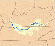 Map of the Cumberland River Watershed | |
| Location | |
| Country | United States |
| State | Kentucky, Tennessee |
| Cities | Williamsburg, KY Burkesville, KY Carthage, TN Nashville, TN Clarksville, TN Dover, TN |
| Physical characteristics | |
| Source | Confluence of the Poor Fork, Clover Fork and Martins Fork |
| • location | Harlan, Kentucky |
| • coordinates | 36°50′42″N 83°19′26″W[1] |
| • elevation | 1,158 ft (353 m) |
| Mouth | Ohio River |
• location | Livingston County, Kentucky |
• coordinates | 37°08′36″N 88°24′27″W[1] |
• elevation | 302 ft (92 m) |
| Length | 688 mi (1,107 km)[2] |
| Basin size | 17,728 sq mi (45,920 km2)[3] |
| Discharge | |
| • location | below Barkley Dam, about 31 mi (50 km) from the mouth[4] |
| • average | 37,250 cu ft/s (1,055 m3/s)[4] |
| • minimum | 6,085 cu ft/s (172.3 m3/s) |
| • maximum | 209,000 cu ft/s (5,900 m3/s) |
| Basin features | |
| Tributaries | |
| • left | Martins Fork, Clear Fork, Big South Fork, Obed River, Caney Fork, Stones River, Harpeth River |
| • right | Clover Fork, Poor Fork, Laurel River, Rockcastle River, Red River, Little River |
Although the Cumberland River basin is predominantly rural, there are also some large cities on the river, including Nashville and Clarksville, both in Tennessee. Also, the river system has been extensively altered for flood control. Major dams impound areas of both the main stem and many of its important tributaries.
Geography
Its headwaters are three separate forks that begin in Kentucky and converge in Baxter, KY, located in Harlan County. Martin's Fork starts near Hensley Settlement on Brush Mountain in Bell County and snakes its way north through the mountains to Baxter. Clover Fork starts on Black Mountain in Holmes Mill, near the Virginia border, and flows west in parallel with Kentucky Route 38 until it reaches Harlan.
Clover Fork once flowed through downtown Harlan and merged with Martins Fork at what is now the intersection of Kentucky Route 38 and US Route 421. A flood control project begun in 1992 diverted it through a tunnel under Little Black Mountain, from which it emerges in Baxter and converges with Martins Fork. Poor Fork begins as a small stream on Pine Mountain in Letcher County near Flat Gap, Virginia. It flows southwest in parallel with Pine Mountain until it merges with the other two forks in Baxter.
From there, the wider, now named Cumberland River continues flowing west through the mountains of Kentucky before turning northward toward Cumberland Falls. The 68-foot (21 m) falls is one of the largest waterfalls in the southeastern United States and is one of the few places in the Western Hemisphere where a moonbow can be seen.[5]
Beyond Cumberland Falls, the river turns abruptly west once again and continues to expand as other creeks and streams feed into it. It receives the Laurel and Rockcastle rivers from the northeast, followed by the Big South Fork of the Cumberland River from the south. From here it flows into the man-made Lake Cumberland, formed by Wolf Creek Dam. The more than 100-mile (160 km) reservoir is one of the largest artificial lakes in the eastern US.
Near Celina, Tennessee, the river crosses south into that state, where it is joined by the Obey River and Caney Fork. Northeast of Nashville, the river is dammed twice more, forming Cordell Hull Lake and Old Hickory Lake. After flowing through Nashville and picking up the Stones River, the river is dammed to form Cheatham Lake. The river turns northwest toward Clarksville, where it is joined by the Red River.
It flows back into Kentucky at the Land Between the Lakes National Recreation Area, a section of land nestled between Lake Barkley, which is fed by the Cumberland River, and Kentucky Lake. Finally, the river flows north and merges with the Ohio River at Smithland, northeast of Paducah.
History

The explorer Thomas Walker of Virginia in 1758 named the river, but whether for the Duke of Cumberland or the English county of Cumberland is not known.[6]
The Cumberland River was called Wasioto by the Shawnee Native Americans, who lived in this area. French traders called it the Riviere des Chaouanons, or "River of the Shawnee" for this association. The river was also known as the Shawnee River (or Shawanoe River) for years after Walker's trip.[1]
Important first as a passage for hunters and settlers, the Cumberland River also supported later riverboat trade, which traveled to the Ohio and Mississippi rivers. Villages, towns, and cities were located at landing points along its banks. Through the middle of the 19th century, settlers depended on rivers as the primary transportation routes for trading and travel.
Floods
In more recent history, a number of severe floods have struck various regions that the river flows through. In April 1977, Harlan, Kentucky, and many surrounding communities were inundated with floodwaters, destroying most of the homes and businesses within the floodplain of the river. This event led to the building of the Martins Fork Dam for flood control and the diversion of the Clover Fork around the city of Harlan. In addition, the river was diverted through a mountain cut in Loyall, Kentucky.
In late April and early May 2010, due to the 2010 Tennessee floods, the river overflowed its banks and flooded Nashville and Clarksville, Tennessee. The downtown area was ordered to evacuate.[7]
Major flooding occurred along the Cumberland River at Pineville, Barbourville, and Williamsburg in early February 2020.[8]
See also
- Quadrula tuberosa — Cumberland River endemic 'Rough rockshell' freshwater mussel.
- List of crossings of the Cumberland River
- List of longest rivers of the United States (by main stem)
- List of rivers of Kentucky
- List of rivers of Tennessee
References
Notes
- "Cumberland River". Geographic Names Information System. United States Geological Survey, United States Department of the Interior. September 20, 1979. Retrieved November 9, 2013.
- U.S. Geological Survey. National Hydrography Dataset high-resolution flowline data. The National Map Archived 2012-03-29 at the Wayback Machine, accessed June 8, 2011
- "Boundary Descriptions and Names of Regions, Subregions, Accounting Units and Cataloging Units". United States Geological Survey. Retrieved November 9, 2013.
- "USGS Gage #03438220 on the Cumberland River near Grand Rivers, KY". National Water Information System. U.S. Geological Survey. 1965–1997. Retrieved November 9, 2013.
- Cumberland Falls Moonbow Retrieved on 2010-05-29
- The Register of the Kentucky State Historical Society, Volume 1. Kentucky State Historical Society. 1903. pp. 35.
- "At least 3 dead in Ky., hundreds of roads flooded". Retrieved May 3, 2010.
- NOAA, US Department of Commerce (2020). "Major Flooding Inundates Southeast Kentucky Followed by Light Snow From February 6-7, 2020". www.weather.gov. Retrieved February 24, 2020.
Bibliography
- Albright, Edward (1908) Early History of Middle Tennessee
- Benke, Arthur and Cushing, Colbert (2005) Rivers of North America. Elsevier Academic Press. ISBN 0-12-088253-1
- Duthie, Bob and Duthie, Mavis (2008) What to Expect Cruising the Cumberland River, CD-ROM
- Hay, Jerry (2010) Cumberland River Guidebook, ISBN 978-1-4507-2458-6
- Kohrs, Randy (2009) "Cumberland" on Quicksand (album) ASIN: B002N1AEI2
- Myers, Fred (2004) Cumberland River CruiseGuide, ISBN 0-9704962-3-0
- Stewart, George R. (1967) Names on the Land. Boston.
- U.S. Geological Survey Geographic Names Information System: Cumberland River
![]() This article incorporates public domain material from the National Oceanic and Atmospheric Administration document: Major Flooding Inundates Southeast Kentucky Followed by Light Snow From February 6–7, 2020.
This article incorporates public domain material from the National Oceanic and Atmospheric Administration document: Major Flooding Inundates Southeast Kentucky Followed by Light Snow From February 6–7, 2020.
External links
- . The American Cyclopædia. 1879.
- . . 1914.
| Authority control |
|---|
На других языках
[de] Cumberland River
Der Cumberland River ist ein etwa 1.106 km langer Fluss in den USA.- [en] Cumberland River
[es] Río Cumberland
El río Cumberland (en inglés: Cumberland River), es un largo río y una importante vía fluvial del sur de los Estados Unidos, y uno de los principales afluentes del río Ohio. Con una longitud de 1106 km es uno de los mayores ríos de los Estados Unidos y drena una cuenca de 46 830 km². Es uno de los tres ríos principales de Kentucky, junto con el río Kentucky y el Big Sandy.[it] Cumberland (fiume)
Il Cumberland (Cumberland River in inglese) è un fiume degli Stati Uniti d'America che attraversa il Kentucky e il Tennessee per una lunghezza di 1.106 chilometri. Il Cumberland è affluente di sinistra del fiume Ohio, quindi sub-affluente del fiume Mississippi.[ru] Камберленд (река)
Ка́мберленд[1] (англ. Cumberland) — река в южных Соединенных Штатах, левый приток реки Огайо. Длина — 1106 км, площадь бассейна 46 830 км². Средний расход воды 774 м³/с. Судоходна на 738 км от устья. Крупные водохранилища. Берёт начало в округе Харлан в восточном Кентукки на плато Камберленд, течёт через юго-восточный Кентукки, пересекает северный Теннесси, затем изгибается, поворачивает на север в западный Кентукки, где впадает в реку Огайо.[источник не указан 1131 день]Другой контент может иметь иную лицензию. Перед использованием материалов сайта WikiSort.org внимательно изучите правила лицензирования конкретных элементов наполнения сайта.
WikiSort.org - проект по пересортировке и дополнению контента Википедии