geo.wikisort.org - River
The Saint John River (French: Fleuve Saint-Jean; Maliseet-Passamaquoddy: Wolastoq) is a 673 kilometres (418 mi) long river that flows from Northern Maine into Canada, and runs south along the western side of New Brunswick, emptying into the Atlantic Ocean in the Bay of Fundy. Eastern Canada's longest river,[2] its drainage basin is one of the largest on the east coast[3] at about 55,000 square kilometres (21,000 sq mi).
Saint John River
| |
|---|---|
 Saint John River in Fredericton, NB | |
 The course of the Saint John River | |
| Etymology | Feast Day of John the Baptist Bountiful and good / the beautiful river |
| Location | |
| Countries |
|
| Provinces | |
| State | Maine |
| Cities | |
| Physical characteristics | |
| Source | Saint John Ponds |
| • location | Somerset County, Maine, United States |
| • elevation | 360 m (1,180 ft) |
| 2nd source | Little Saint John Lake |
| • location | Saint-Zacharie, Quebec, Canada |
| 3rd source | Lac Frontière |
| • location | Montmagny Regional County Municipality, Quebec, Canada |
| Source confluence | |
| • location | Aroostook County, Maine, United States |
| • coordinates | 46°33′47″N 69°53′06″W |
| Mouth | Bay of Fundy |
• location | Saint John, New Brunswick, Canada |
• coordinates | 45°16′N 66°4′W |
| Length | 673 km (418 mi)[1] |
| Basin size | 54,986 km2 (21,230 sq mi) |
| Discharge | |
| • average | 990 m3/s (35,000 cu ft/s) |
| Basin features | |
| Tributaries | |
| • left | Tobique River, Jemseg River, Belleisle Bay, Kennebecasis River |
| • right | Allagash River, Aroostook River, Nerepis River |
| Designations | |
|---|---|
National Historic Site of Canada | |
| Official name | Wolastoq National Historic Site of Canada |
| Designated | July 19, 2011 |
| Reference no. | 18954 |
A part of the border between New Brunswick and Maine follows 130 km (80 miles) of the river. A tributary forms 55 km (35 miles) of the border between Quebec and Maine.
New Brunswick settlements through which it passes include, moving downstream, Edmundston, Fredericton, Oromocto, and Saint John.
It is regulated by hydro-power dams at Mactaquac, Beechwood, and Grand Falls, New Brunswick.
Hydronym
Samuel de Champlain visited the mouth of the river on the feast day of John the Baptist in 1604 and renamed it the Rivière Saint-Jean or Saint John River in English. [4][5] Many waterways in the system retain their original pre-European names.[6] The Maliseet call it the Wolastoq, meaning bountiful and good and seek to restore this name.[7]
Geography and ecology
Upper basin
The headwaters are in the New England/Acadian forests of Maine and Quebec,[8] including the Southwest, Northwest, and Baker branches, and the Allagash River flowing into New Brunswick at Edmundston where it is joined by the Madawaska River.
Middle basin
The middle section runs from the confluence of the Aroostook and Tobique rivers, flowing southeast to Mactaquac Dam. Other tributaries in this section include the Meduxnekeag River. This area is the only place in Atlantic Canada where Appalachian Hardwood Forest is found.[9] Plants rare for the province include wild ginger, black raspberry, wild coffee, maidenhair fern, showy orchis and others.[10] This forest type, also known as the Saint John River Valley Hardwood Forest, once spread of much of the area and has been reduced to less than one percent of the land area because of human activities.[11] This is an area of rolling hills and soils that are the most fertile and heavily farmed in New Brunswick. Soils are fine, loamy, and well-drained glacial tills overlaying limestone and sandstone.[11]
The climate here is drier and warmer than surrounding regions.
Lower basin
The lower basin, 140 kilometres (90 miles) to Saint John Harbour on the Bay of Fundy, consisting of lakes, islands, wetlands and a tidal estuary. Tributaries in this section include the Nashwaak and Nerepis rivers and Belleisle Bay.
The final tributary, the Kennebecasis River, is a fjord[12] with a sill, or rise in depth near the mouth of a fjord caused by a terminal moraine. From the Grand Bay (New Brunswick), the waterway becomes narrower and deeper forming a gorge where at the Reversing Falls incoming tide forces the flow of water to reverse against the prevailing current. A wedge of salt water, below a surface covering of fresh water, extends upriver to the 10 metre (30') shallows at Oak Point beyond which it cannot advance.[13]
Formation and hydrology
The drainage basin is 55,000 square kilometres (21,000 sq mi), of which 20,000 square kilometres (7,700 sq mi) is Maine. The average discharge is 1,100 m3/s (39,000 cu ft/s).[1] Water flow is lowest in the autumn, and considerably higher than average during the spring freshet at 6,800 m3/s (240,000 cu ft/s).[13] In early spring, upper sections of the river can experience ice jams causing flooding. In the lower sections in the broader floodplain, flooding may occur during late spring from the volume of water which must make its way through the narrow gorge at the Reversing Falls.
Legally, all of the river downstream of a point between Fredericton and Mactaquac Provincial Park is considered tidal.[14]
The river is mostly calm, except for waterfalls at Grand Falls and at the Beechwood Dam.[1]
Flooding
With the water flow in the spring being six times the average rate, the valley has always been prone to flooding in the spring. Surface runoff from heavy rainfall is the main cause of flooding, and can be exacerbated by ice jams, high tides, and rapid snowmelt.[15] Floods have been documented for more than 300 years.[16] Flooding has occurred in Edmundston, Grand Falls, Perth-Andover, Hartland, Woodstock, and most severely around Fredericton and Saint John.
Major flooding has occurred in 1923, with water 8 metres (26') above normal winter low. In 1936 high temperatures quickened snowmelt, and heavy rain raised the water level to 8.9 metres (30'), about 7.6 metres (25') above summer level. Similar circumstances led to the same level of high water in the 1973 flood. Similar major flooding occurred again in 2018 and 2019. Since 2019, flooding has not been as severe.
The severity and frequency of flooding is expected to increase,[17] with climate change.[18] It is predicted that New Brunswick's average temperature will increase by 5 C (9°F) by the year 2100, and that precipitation will increase.[19]
Human history
At the end of the last glacial period, following the retreat of the Laurentide Ice Sheet about 13,000 years ago, the area was stripped bare of vegetation and soil. By about 10,000 years ago, Paleo-Indians probably occupied what is now New Brunswick.[20]
Although the basin has been subject to human influence for thousands of years, the Native American impact was minimal partly because of their small numbers, and partly because they practised low intensity agriculture.[21] Major disturbances did not begin until the early 1800s[11] with the arrival of large numbers of Europeans.
When the Europeans arrived into Wolastokuk, the homeland of the Maliseet Nation and Saint John River basin, they found the locals hunting, gathering, and farming near the banks of the river.[22] European colonists may have used fields and town sites prepared by the natives.[23] Archaeological evidence is that the Maliseet had economic and cultural ties with large portions of North America[23] from their country's homebase within the Wabanaki Confederacy of Dawnland. The Maliseet dealt with freshets by having their village above the floodplain, for example Meductic,[11] while cultivating at a lower elevation where the fields were fertilized by the floodwaters.[24] The Maliseet were highly mobile and the Saint John River was a primary means of transportation.[11]
While the Maliseet saw themselves as part of the ecosystem, the Europeans' Christian world view held humans are raised above nature by their creator, and must not merely exist as the beasts of the field, but explore and develop nature.[21]
During the 1600 and 1700s, French colonists populated the lower river valley as part of Acadia, with Fort Nashwaak in present-day Fredericton, Fort Boishebert at the confluence of the Saint John and Nerepsis rivers. In the French seigneurial system lands were arranged in long, narrow strips, called seigneuries, along the banks of the river. However this was not practical given the seasonal flooding, and the Acadians moved to higher ground.[24]
Decades of warfare between the British colonies in what is now New England and Acadia, led to the expulsion of the Acadians in 1784. Following the American Revolutionary War, United Empire Loyalists settled the area. Returning Acadians settled the upper valley.
Large numbers of people began settling the area in the early 1800s, mostly Scottish and Irish, and by the end of the 1850s much of the central Saint John valley had been cleared of old-growth forest for farming. Francophone Quebecers moved into the northern areas. In the interwar period, many of these farms were abandoned due to urbanization, and allowed to reforest.[11]
Before the advent of railways, the river was an important trade route, including timber rafting.
In 1925 a hydroelectric dam was built at Grand Falls, followed in 1955 by the Beechwood Dam and the Mactaquac Dam in 1965. Large reservoirs were created behind the dams. Construction of the latter two dams has caused a severe decline in migrating Atlantic salmon, and resource authorities have developed fish ladders and other measures to try to revive the migration.
In 2011, the entire watershed was designated the Wolastoq National Historic Site, and is as the traditional territory of the Wolastoqiyik First Nation.[25]
The forested areas of the Maine North Woods where the river rises is mostly uninhabited. The Northwest Aroostook, Maine unorganized territory has an area of 2,668 square miles (6,910 km2) and a population of 10, or one person for every 267 square miles (690 km2).
Gallery
 Saint John, NB
 2008 Saint John River Flood
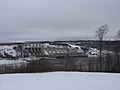 Mactaquac Dam
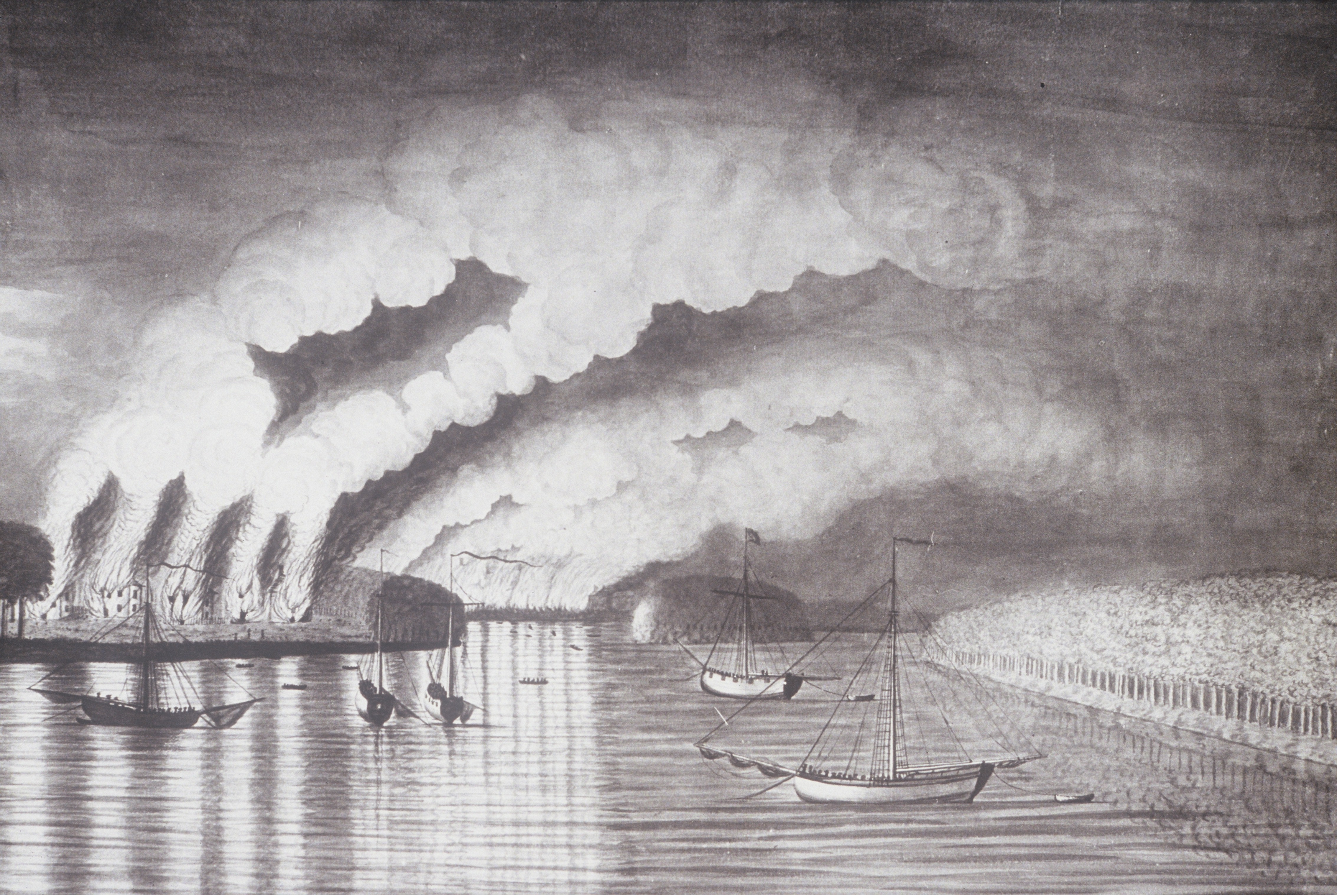
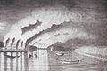 St. John River Campaign: A View of the Plundering and Burning of the City of Grimross (present day Gagetown, New Brunswick) by Thomas Davies in 1758. This is the only contemporaneous image of the Expulsion of the Acadians.
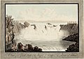 Great Falls on the River St. John, New Brunswick, by Henry Holland, c. 1782.
 View of the railroad bridge at Woodstock looking south in Spring
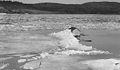 Spring freshet and ice break up near Westfield on the Saint John River, 1936


See also
- List of crossings of the Saint John River
- List of longest rivers of Canada
- List of rivers of Maine
- List of bodies of water of New Brunswick
References
- "Saint John River". The Canadian Encyclopedia. Archived from the original on 27 December 2018. Retrieved 27 December 2018.
- Esrock, Robin. "St. John River Valley". National Geographic. Archived from the original on 27 December 2018. Retrieved 27 December 2018.
- "St. John Watershed". Maine Rivers. Archived from the original on 19 October 2016. Retrieved 27 December 2018.
- MacGregor, Roy. "Fishing for answers". The Globe and Mail. Archived from the original on 28 November 2017. Retrieved 27 December 2018.
- "Saint John River". Natural Resources Canada. Government of Canada. Archived from the original on 30 December 2018. Retrieved 27 December 2018.
- "St. John River: The Good and the Bountiful". Canadian Geographic. Archived from the original on 27 December 2018. Retrieved 27 December 2018.
- Poitras, Jacques (June 8, 2017). "Maliseet want name of St. John River changed back to 'Wolastoq', but no consensus on spelling". CBC News. Archived from the original on July 15, 2017. Retrieved July 21, 2017.
- Olson; D. M; E. Dinerstein; et al. (2001). "Terrestrial Ecoregions of the World: A New Map of Life on Earth". BioScience. 51 (11): 933–938. doi:10.1641/0006-3568(2001)051[0933:TEOTWA]2.0.CO;2. ISSN 0006-3568. Archived from the original on October 14, 2011.
- "Appalachian Hardwoods". Nature Trust of New Brunswick. Archived from the original on 29 December 2018. Retrieved 28 December 2018.
- "Ecology". Meduxnekeag River Association. Archived from the original on 29 December 2018. Retrieved 28 December 2018.
- MacDougall, Andrew; Loo, Judy (1998). "Natural history of the St. John River Valley hardwood forest of western New Brunswick and northeastern Maine" (PDF). Government of Canada. Atlantic Forestry Centre. Archived (PDF) from the original on 2 November 2016. Retrieved 29 December 2018.
- "Lower Saint John River". UNB Engineering. Archived from the original on 27 December 2018. Retrieved 27 December 2018.
- Clarke, John; Winistock, John. "Kennebecasis -Grand Bay Sill: A view of the salt and fresh water exchange in the lower St. John River". University of New Brunswick. Archived from the original on 26 April 2018. Retrieved 27 December 2018.
- "Tidal Waters". Government of New Brunswick. Archived from the original on 29 December 2018. Retrieved 29 December 2018.
- Government of New Brunswick, Canada (2015-09-11). "Flooding in New Brunswick". www2.gnb.ca. Archived from the original on 2019-01-01. Retrieved 2018-12-31.
- Apr 30, Julia Wright · CBC News · Posted; April 30, 2018 5:41 PM AT | Last Updated. "Worst floods in New Brunswick history: how 2018 compares | CBC News". CBC. Archived from the original on 2019-02-26. Retrieved 2018-12-31.
- "New Brunswick's Flood Risk Reduction Strategy" (PDF). www2.gnb.ca. Archived (PDF) from the original on 2019-01-01. Retrieved 2018-12-31.
- "Key climate-change vulnerabilities identified for three St. John River communities". Canadian News Wire. Archived from the original on 28 December 2018. Retrieved 27 December 2018.
- "Scientist says record floods show that New Brunswick must adapt to changing world | Globalnews.ca". globalnews.ca. 2018-05-07. Archived from the original on 2019-01-01. Retrieved 2018-12-31.
- Foot, Richard (2010). "Prehistory". Archived from the original on 28 December 2018. Retrieved 27 December 2018.
- Dalton, Shawn (2015). "A social ecological history of the st john river watershed". Retrieved 29 December 2018.
- "Wolastoqiyik (Maliseet)". The Canadian Encyclopedia. Archived from the original on 28 December 2018. Retrieved 27 December 2018.
- Hall, Jason (2015). "Maliseet Cultivation and Climatic Resilience on the Wəlastəkw/St. John River During the Little Ice Age". Acadiensis. Archived from the original on 28 December 2018. Retrieved 27 December 2018.
- Hall, Jason. "The Environmental and Cultural History of the St. John River". NICHE. Archived from the original on 29 December 2018. Retrieved 28 December 2018.
- "Wolastoq National Historic Site of Canada". Parks Canada. Government of Canada. Archived from the original on 27 December 2018. Retrieved 27 December 2018.
External links
![]() Media related to Saint John River at Wikimedia Commons
Media related to Saint John River at Wikimedia Commons
National Historic Sites of Canada by location | |
|---|---|
| Provinces |
|
| Territories |
|
| Other countries |
|
| |
Authority control | |
|---|---|
| General | |
| Other | |
На других языках
[de] Saint John River
Der Saint John River (französisch Rivière Saint-Jean) ist ein 673 km langer Fluss im nordöstlichen Nordamerika. Er entspringt im US-Bundesstaat Maine, fließt durch die kanadische Provinz New Brunswick und mündet in der Bay of Fundy in den Atlantischen Ozean. Teilweise bildet er die Grenze zwischen den Vereinigten Staaten und Kanada. Um Verwechslungen mit dem St. Johns River in Florida zu vermeiden, wird das "Saint" im Falle des in Kanada mündenden Flusses häufig ausgeschrieben.- [en] Saint John River (Bay of Fundy)
[es] Río Saint John (bahía de Fundy)
El río Saint John/Saint-Jean (en inglés, Saint John River; en francés, Fleuve Saint-Jean; lit., 'río [de] San Juan') es un largo río del noreste de Estados Unidos y este de Canadá —durante un tramo, forma frontera entre estos dos países— que fluye en direcciones NE y SE a través de Maine (EE. UU.) y Nuevo Brunswick (Canadá) hasta desaguar en la bahía de Fundy (golfo de Maine, océano Atlántico). Con una longitud de 673 km es uno de los 20 primarios más largos de los Estados Unidos y drena una cuenca de 54 990 km², de los que poco más de la mitad pertenecen a Nuevo Brunswick.[it] Saint John (fiume Canada)
Il Saint John è un fiume lungo 673 km (418 miglia), che attraversa la provincia canadese del Nuovo Brunswick e lo Stato statunitense del Maine. Lungo il suo corso costituisce per due volte il confine tra Canada e Stati Uniti. Il suo bacino ha una superficie di circa 55.000 km², di cui poco più della metà si trova nel Nuovo Brunswick. Il Saint John è anche il secondo fiume più lungo della costa atlantica del Nord America (quella compresa tra il fiume San Lorenzo e il fiume Mississippi) dopo il Susquehanna.[ru] Сент-Джон (река)
Сент-Джон (англ. Saint John River, фр. Fleuve Saint-Jean) — река в Северной Америке, образует часть государственной границы США и Канады, между штатом Мэн и провинцией Нью-Брансуик. Площадь бассейна примерно 55 000 км², чуть более половины приходится на Нью-Брансуик. Вторая (после Саскуэханны) по длине среди североамериканских рек, впадающих в Атлантический океан между устьем Святого Лаврентия и Миссисипи.Другой контент может иметь иную лицензию. Перед использованием материалов сайта WikiSort.org внимательно изучите правила лицензирования конкретных элементов наполнения сайта.
WikiSort.org - проект по пересортировке и дополнению контента Википедии