geo.wikisort.org - Island
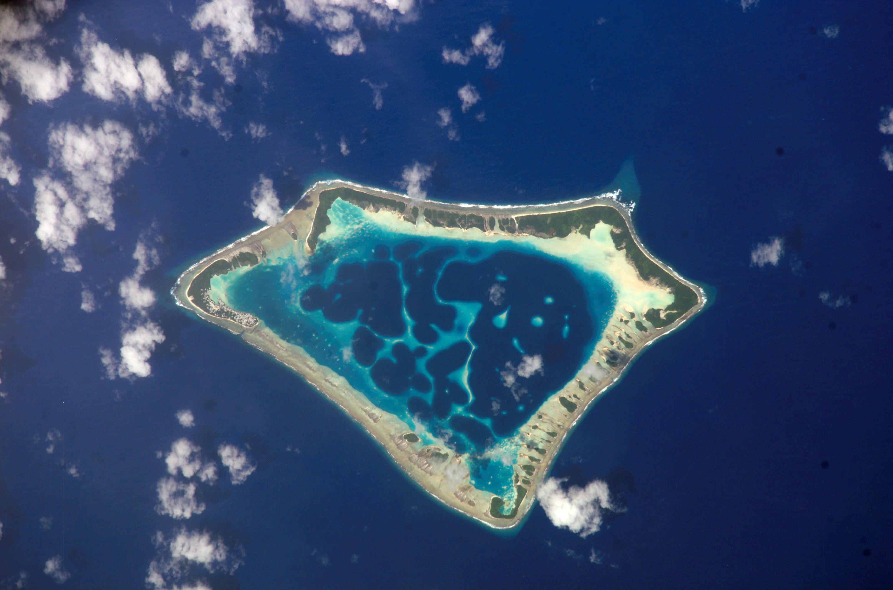
Atafu, formerly known as the Duke of York Group, is a group of 52 coral islets within Tokelau in the south Pacific Ocean, 500 kilometres (310 miles) north of Samoa.[1] With a land area of 2.5 square kilometres (1.0 square mile), it is the smallest of the three islands that constitute Tokelau. It is an atoll and surrounds a central lagoon, which covers some 15 km2 (5.8 sq mi). The atoll lies some 800 kilometres (500 miles) south of the equator at 8° 35' South, 172° 30' West.
 | |
 Atafu  Atafu  Atafu | |
| Geography | |
|---|---|
| Archipelago | Tokelau |
| Total islands | 52 |
| Area | 2.5 km2 (0.97 sq mi) |
| Administration | |
New Zealand | |
| Dependent territory | Tokelau |
| Demographics | |
| Population | 541 |
| Languages | Tokelauan, English |
Population
According to the 2016 census, 541 people officially live on Atafu (although only 413 were present the night the census was taken).[2] Of those present, 78% belong to the Congregational Church.[3] The main settlement on the atoll is located on Atafu Island in its northwestern corner. The Presbyterian church was established on the island in 1858, but today almost all of the residents belong to the Congregational Christian Church.[3] The first village on Atafu was established at its southern end: Residents built houses along the lagoon shore to take best advantage of the cooling trade winds.
Fishing is traditionally done by the men on Atafu, and they are highly skilled at it. They use many traditional methods that are passed on from fathers to sons. They create very effective lures, fish traps, nets, and seines. They commonly use the technique called "noose fishing", in which a circle of rope, tied with a noose knot, is dangled in the water; a large fish swims into the rope circle, lured by bait, and the noose is then tightened around its body, holding it fast.[4] They also make well-crafted canoes, which they use for their fishing expeditions.
Geography

Atafu lies in the Pacific hurricane belt. In January 1914, a massive storm demolished the church and most of the houses on the islands, and wiped out many of the coconut palms.[5]
The atoll is roughly triangular in shape and encloses a lagoon some five kilometres (3.1 miles) north to south by four kilometres (2.5 miles) east to west at its widest point. It is low-lying, reaching a maximum altitude of only some five metres (16 feet), and is heavily vegetated with coconut palms and other trees, with undergrowth similar to that found on many small central Pacific islands. Lizards, rats, and seabirds are common on Atafu island.[5] The atoll attracts a wide variety of fish in large numbers.
The eastern side of the lagoon is a nearly continuous thin strip of land with one small break halfway along its length. In contrast, the western side is composed of reef and several distinct islands, notably the inverted V shape of Atafu Island in the north, Alofi, which extends into the lagoon from the western reef, and the L-shaped Fenualoa in the southwest. The smaller Tamaseko Island lies in the lagoon close to Alofi.
The reef which connects the islands of the atoll is shallow enough that it is possible to walk between the islands at low tide. This also means that there is no boat passage to the lagoon, although the ocean becomes deep very close to the reef. This allows for good anchorage, but also makes for rough seas close to the reef. The flatness of the atoll and its location within the tropical cyclone belt has led to damage to island properties on occasion.
Important Bird Area
Some 70 ha of the southern and south-western parts of the atoll have been designated an Important Bird Area (IBA) by BirdLife International because the site supports breeding colonies of brown and black noddiess and common white terns, with about 30,000 breeding pairs estimated in 2011.[6]
Islets
- Fogalaki i Lalo
- Fogalaki-Matangi (Fogalaki i Matagi)
- Te Oki
- Te Hepu
- Laualalava
- Te Kapi
- Na Utua
- Motu Atea
- Motu Fakalalo
- Tama Hakea
- Hakea Lahi ki Matagi
- Hakea O Himi
- Malatea
- Kenakena
- Malo o Futa
- Motu o Te Lakia
- Komulo
- Hakea o Apelamo
- Na Hapiti
- Niuefa
- Fenualoa
- Te Puka
- Tamaheko
- Te Alofi
- Tulua a Kovi
- Tagi a Kuli
- Hakea o Himi
- Tulua a Kava
- Motu o te Niu
- Malatea
- Hakea o Hoi
- Hakea o Fata
- Kenakena
- Matu o Tenumi
- Matu o te Lakia
- Motu Fakaka kai
- Malo o Futa
- Malo o Futa
- Motu o te Fala
- Tafega
- Komulo
- Hakela Lahi i Lalo
- Hotoma
- Hakea o Apelamo
- Na Hapiti
- Niuefa
- Fenualoa
- Te Puka
- Tamaheko
- Te Alofi
- Ulugagie
- Atafu Village
History

It is likely that Polynesians visited the island in ancient times, but they may not have settled there. The European discovery of the atoll came on 21 June 1765; it was made by John Byron, of HMS Dolphin. Byron found no one living on the island at that time.[4] He named the island "Duke of York's island".[7] Atafu was established by a couple, a husband, named Tonuia, and his wife, named Lagimaina, along with their seven children.[8]
Between 1856 and 1979, the United States claimed sovereignty over the island and the other Tokelauan atolls. In 1979, the U.S. conceded that Tokelau was now under New Zealand sovereignty, and a maritime boundary between Tokelau and American Samoa was established by the Treaty of Tokehega.
On 26 August 2007, Ralph Tuijn, who was attempting to row a boat all the way from South America to Australia, crashlanded on Atafu.[9] On 26 November 2010, three teenage boys from Atafu were rescued after having drifted 1,300 km (800 mi) for 50 days in the Pacific.[10][11]
See also
References
- Tokelau Government
- "2016 Tokelau Census atoll profiles" (PDF). tokelau.org.nz.
- "2016 Final data tables" Retrieved 13-07-2017
- "Atafu". Council for the Ongoing Government for Tokelau. Archived from the original on 15 August 2007. Retrieved 5 April 2008.
- Atafu Island on janeresture.com
- "Atafu". BirdLife Data Zone. BirdLife International. 2021. Retrieved 7 March 2021.
-
- Quanchi, Max (2005). Historical Dictionary of the Discovery and Exploration of the Pacific Islands. The Scarecrow Press. ISBN 0810853957.
- Ethnology of the Tokelau Islands, Gordon MacGregor, 1937
- "Zeeman Ocean Challenge". Archived from the original on 8 February 2012. Retrieved 1 September 2007.
- Field, Michael (27 November 2010). "Boozy teens' midnight trip goes 1300km astray". The Dominion Post. Retrieved 17 September 2011.
- "Joy in Tokelau over rescue of missing teenagers". Radio New Zealand International. 27 November 2010. Retrieved 27 November 2010.
External links
| Authority control |
|
|---|
На других языках
[de] Atafu
Atafu (früher Duke of York’s Island) ist ein aus über vierzig kleinen Motus bestehendes Atoll im Pazifik, das mit den beiden anderen Atollen Fakaofo und Nukunonu die Gruppe der politisch zu Neuseeland gehörenden Tokelau-Inseln bildet. Nach der Volkszählung 2016 sind auf Atafu offiziell 541 Menschen ansässig, von denen zum Zeitpunkt der Zählung jedoch nur 413 anwesend waren.[1] Von den beim Zensus Anwesenden bekannten sich 78,3 % zur Congregational Church. Dies ist ein deutlicher Rückgang gegenüber 2006, als noch mehr als 95 % der Bevölkerung dieser Glaubensgemeinschaft angehörten.[2]- [en] Atafu
[es] Atafu
Atafu, antiguamente conocida como «grupo del Duque de York» es un grupo de islotes de coral en Tokelau en el sur del océano Pacífico. Con una superficie de 2,5 km², es la más pequeña de las tres islas que constituyen Tokelau, y está compuesta de un atolón que rodea una laguna central con una superficie de 15 km². El atolón está unos 800 km al sur del ecuador.[fr] Atafu
Atafu est un ensemble de quarante-deux îlots de corail aux Tokelau. Atafu est, avec une surface totale de 2,5 km2, le plus petit des trois groupes d'îles qui constituent le territoire des Tokelau - les deux autres étant Fakaofo et Nukunonu. Il a la forme d'un atoll, et comprend en son centre un lagon, lequel recouvre environ 15 km2. Atafu se trouve à 172° 30' ouest, 8° 35' sud. Il s'agit de la terre la plus septentrionale de Nouvelle-Zélande.[it] Atafu
Atafu, conosciuto come Gruppo Duca di York, è un gruppo di quarantadue isolotti corallini facenti parte delle isole Tokelau.Другой контент может иметь иную лицензию. Перед использованием материалов сайта WikiSort.org внимательно изучите правила лицензирования конкретных элементов наполнения сайта.
WikiSort.org - проект по пересортировке и дополнению контента Википедии