geo.wikisort.org - Island
The United States claimed a number of islands as insular areas under the Guano Islands Act of 1856. Only the eight administered as the US Minor Islands and the ones part of Hawaii and American Samoa remain under the jurisdiction of the United States. Any other unresolved claims, if they exist are dormant, and have not been contested by the United States in many years, with the exception of Navassa.
Table
| Island | Region | Alternate name | Coordinates | Current status | Resolution of U.S. claim[1] |
|---|---|---|---|---|---|
| Alto Velo Island | Caribbean | Alta Vela Island; Isla Alto Velo | 17°28′42″N 71°38′05″W | Dominican Republic | Rejected. See Alto Velo Claim. |
| Atafu | Oceania | Duke of York Group | 8°33′06″S 172°30′03″W | Tokelau | Treaty of Tokehega |
| Bajo Nuevo Bank | Caribbean | Petrel Islands | 15°53′N 78°38′W | Disputed | Remains in place as an unincorporated territory. De facto administered by Colombia, and also claimed by Jamaica and Nicaragua. |
| Baker Island | Oceania | New Nantucket | 0°11′41″N 176°28′46″W | US Minor Islands | Unincorporated territory |
| Birnie Island | Oceania | 3°35′S 171°33′W | Kiribati | Treaty of Tarawa | |
| Butaritari | Oceania | Makin Atoll, Makin Island, Touching Island | 3°10′04″N 172°49′33″E | Kiribati | Treaty of Tarawa |
| Caroline Island | Oceania | Millennium Island | 9°56′13″S 150°12′42″W | Kiribati | Treaty of Tarawa |
| Carondelet Reef | Oceania | 5°34′S 173°51′W | Kiribati | Treaty of Tarawa | |
| Clipperton Island | Pacific Ocean | Passion Island | 10°18′N 109°13′W | France | Original treaty between Mexico and France. Also claimed by Mexico. |
| Ducie Island | Oceania | 24°40′09″S 124°47′11″W | British Territory | Dormant. Administered by Pitcairn Islands. | |
| Enderbury Island | Oceania | Guano Island | 3°08′S 171°05′W | Kiribati | Treaty of Tarawa |
| Fakaofo | Oceania | Bowditch Island | 9°21′55″S 171°12′54″W | Tokelau | Treaty of Tokehega |
| Flint Island | Oceania | 11°25′48″S 151°49′9″W | Kiribati | Treaty of Tarawa | |
| French Frigate Shoals | Oceania | Kānemilohaʻi | 23°44′56″N 166°8′46″W | Hawaii | Assumed sole competing claim through annexation of Hawaii (1898); included in State of Hawaii (1959). |
| Funafuti | Oceania | 8°31′S 179°13′E | Tuvalu | Tuvalu–US Treaty of 1983 | |
| Howland Island | Oceania | Worth Island | 0°48′07″N 176°38′3″W | US Minor Islands | Unincorporated territory |
| Isla de Aves | Caribbean | Isla de Aves | 15°40′18″N 63°36′59″W | Venezuela | United States–Venezuela Maritime Boundary Treaty |
| Îles du Connétable | Atlantic Ocean | Constable Islands | 4°49′25″N 51°56′11″W | France | Rescinded. Administered by French Guiana. |
| Jarvis Island | Oceania | Bunker Island | 0°22′S 160°01′W | US Minor Islands | Unincorporated territory |
| Johnston Atoll | Oceania | 16°44′13″N 169°31′26″W | US Minor Islands | Unincorporated territory | |
| Kanton Island | Oceania | Canton Island | 2°50′S 171°40′W | Kiribati | Treaty of Tarawa |
| Kingman Reef | Oceania | Danger Rock | 6°24′N 162°24′W | US Minor Islands | Unincorporated territory |
| Kiritimati | Oceania | Christmas Island | 1°52′N 157°24′W | Kiribati | Treaty of Tarawa |
| Lacepede Islands | Oceania | Lacapade [sic] Islands | 16°51′55″S 122°08′12″E | Australia | Claim made on 26 June 1876; repudiated by US government in 1877. |
| Makin (atoll) | Oceania | Little Makin | 3°23′00″N 173°00′00″E | Kiribati | Treaty of Tarawa |
| Malden Island | Oceania | Independence Island | 4°01′S 154°56′W | Kiribati | Treaty of Tarawa |
| Manihiki | Oceania | Island of Pearls | 10°24′S 161°00′W | Cook Islands | Cook Islands–United States Maritime Boundary Treaty |
| Manra | Oceania | Sydney Island | 4°27′S 171°16′W | Kiribati | Treaty of Tarawa |
| McKean Island | Oceania | Wigram Island | 3°35′S 174°02′W | Kiribati | Treaty of Tarawa |
| Midway Atoll | Oceania | Middlebrook Islands | 28°12′N 177°21′W | US Minor Islands | Unincorporated territory |
| Minami-Tori-shima | Oceania | Marcus Island | 24°18′N 153°58′E | Japan | Returned to Japan in 1968 after it had been given to US by Treaty of San Francisco |
| Navassa Island | Caribbean | Navaza | 18°24′10″N 75°0′45″W | Disputed | Administered by the United States as an unincorporated territory and one of the US Minor Islands. Also claimed by Haiti. |
| Nikumaroro | Oceania | Gardner Island | 4°40′S 174°31′W | Kiribati | Treaty of Tarawa |
| Niulakita | Oceania | Sophia Island | 10°45′S 179°30′E | Tuvalu | Tuvalu–US Treaty of 1983 |
| Nukufetau | Oceania | 8°00′S 178°30′E | Tuvalu | Tuvalu–US Treaty of 1983 | |
| Nukulaelae | Oceania | 9°22′52″S 179°51′08″E | Tuvalu | Tuvalu–US Treaty of 1983 | |
| Nukunonu | Oceania | Duke of Clarence Island | 9°10′06″S 171°48′35″W | Tokelau | Treaty of Tokehega |
| Orona | Oceania | Hull Island | 4°30′S 172°10′W | Kiribati | Treaty of Tarawa |
| Palmyra Atoll | Oceania | 5°53′N 162°5′W | US Minor Islands | Incorporated territory.[2] U.S. assumed sole competing claim through annexation of Hawaii (1898), but not included in State of Hawaii (1959). | |
| Penrhyn Island | Oceania | Tongareva | 9°00′20″S 157°58′10″W | Cook Islands | Cook Islands–United States Maritime Boundary Treaty |
| Pukapuka | Oceania | San Bernardo Island | 10°53′S 165°40′W | Cook Islands | Cook Islands–United States Maritime Boundary Treaty |
| Quita Sueño Bank | Caribbean | Quitasueño | 14°19′N 81°10′W | Colombia | Vásquez–Saccio Treaty of 1972 |
| Rakahanga | Oceania | Grand Duke Alexander Island | 10°02′S 161°05′W | Cook Islands | Cook Islands–United States Maritime Boundary Treaty |
| Rawaki Island | Oceania | Phoenix Island | 3°42′40″S 170°42′43″W | Kiribati | Treaty of Tarawa |
| Roncador Bank | Caribbean | 13°34′N 80°05′W | Colombia | Vásquez–Saccio Treaty of 1972 | |
| Rosalind Bank | Caribbean | Rosa Linda Bank | 16°26′N 80°31′W | Disputed | Multiple nations claim this submerged bank as a part of their EEZs. The Colombia–US Vásquez–Saccio Treaty of 1972 is silent on the matter. Administered by Colombia, and claimed by Nicaragua, Honduras, the United States, and Jamaica. |
| Scorpion Reef | Gulf of Mexico | Arrecife Alacranes (Isla Pérez, Isla Chica, Isla Pájaros) | 22°24′N 89°42′W | Mexico | Abandoned claim in 1894[3] |
| Serrana Bank | Caribbean | 14°20′N 80°20′W | Colombia | Vásquez–Saccio Treaty of 1972 | |
| Serranilla Bank | Caribbean | 15°50′N 79°50′W | Disputed | Remains in place as an unincorporated territory. Colombia and Jamaica agreed to a condominium of Serranilla's exclusive economic zone; Nicaragua also lays claim. | |
| Starbuck Island | Oceania | Volunteer Island | 5°37′S 155°56′W | Kiribati | Treaty of Tarawa |
| Swains Island[4] | Oceania | Olohega, Olosega, Quirós, Isla de la Gente Hermosa, Jennings Island | 11°03′20″S 171°04′40″W | American Samoa | Treaty of Tokehega |
| Swan Islands | Caribbean | Islas Santanilla | 17°24′38″N 83°55′19″W | Honduras | Honduras–US Treaty of 1972 |
| Tabuaeran | Oceania | Fanning Island | 3°51′36″N 159°21′52″W | Kiribati | Treaty of Tarawa |
| Teraina | Oceania | Washington Island | 4°41′00″N 160°22′40″W | Kiribati | Treaty of Tarawa |
| Vostok Island | Oceania | Staver Island | 10°06′S 152°23′W | Kiribati | Treaty of Tarawa |
| Winslow Reef | Oceania | 1°36′S 174°57′W | Kiribati | Treaty of Tarawa |
Images
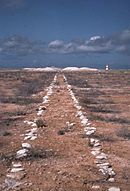 Guano tramway on Jarvis Island
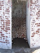 Hermit crabs on Baker Island
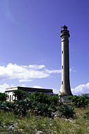 Navassa Island Lighthouse


See also
- Guano
- Insular area
- Territories of the United States
- Pacific Remote Islands Marine National Monument
References
- "Formerly Disputed Islands". Office of Insular Affairs. 2007-01-11. Archived from the original on 2007-09-30. Retrieved 2009-09-09.
- "History: Under the American Flag". Office of Insular Affairs. 2006-01-30. Archived from the original on 2012-01-11. Retrieved 2009-09-09.
- Magoon 1900, p. 16.
- Skaggs, Jimmy M. (1994). The Great Guano Rush: Entrepreneurs and American Overseas Expansion. New York: St. Martin's Press. p. 213. ISBN 0-312-10316-6. OCLC 28506113..
Further reading
- Magoon, Charles E. (1900). Report on the Legal Status of the Territory and Inhabitants of the Islands Acquired by the United States During the War with Spain. Washington: U.S. Government Printing Office.
- Moore, J.B.; Wharton, F.; United States. President; United States. Dept. of State; United States. Dept. of Justice (1906). A Digest of International Law: As Embodied in Diplomatic Discussions, Treaties and Other International Agreements, International Awards, the Decisions of Municipal Courts, and the Writings of Jurists ... U.S. Government Printing Office. p. 574. Retrieved 2015-11-09.
Territorial expansion of the United States | ||
|---|---|---|
|  | |
| ||
List of states and territories | |
| States |
|
| Federal district | Washington, D.C. |
| Insular areas |
|
| Outlying islands |
|
| Indian reservations |
|
| Others |
|
Текст в блоке "Читать" взят с сайта "Википедия" и доступен по лицензии Creative Commons Attribution-ShareAlike; в отдельных случаях могут действовать дополнительные условия.
Другой контент может иметь иную лицензию. Перед использованием материалов сайта WikiSort.org внимательно изучите правила лицензирования конкретных элементов наполнения сайта.
Другой контент может иметь иную лицензию. Перед использованием материалов сайта WikiSort.org внимательно изучите правила лицензирования конкретных элементов наполнения сайта.
2019-2025
WikiSort.org - проект по пересортировке и дополнению контента Википедии
WikiSort.org - проект по пересортировке и дополнению контента Википедии