geo.wikisort.org - Island
Fakaofo, formerly known as Bowditch Island, is a South Pacific Ocean atoll located in the Tokelau Group. The actual land area is only about 3 km2 (1.1 sq mi), consisting of islets on a coral reef surrounding a central lagoon of some 45 km2. According to the 2006 census 483 people officially live on Fakaofo (however just 370 were present at census night). Of those present 70% belong to the Congregational Church and 22% to the Catholic Church.[1]
 Aerial view of Fakaofo | |
 A map of Fakaofo Atoll and all its islands (map in Polish) | |
 Fakaofo  Fakaofo  Fakaofo | |
| Geography | |
|---|---|
| Archipelago | Tokelau |
| Total islands | 43 |
| Major islands | Fale on Pacific Ocean |
| Area | 3 km2 (1.2 sq mi) |
| Administration | |
New Zealand | |
| Dependent territory | Tokelau |
| Largest settlement | Fale |
| Demographics | |
| Population | 483 |
| Languages | Tokelauan, English |
Geography and government

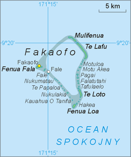
The main settlement on the island is Fale on Fale Islet, towards the western side of the atoll. Located two kilometres to the west of it is the relatively large Fenua Fala Islet, where a second settlement was established in 1960. Other islets in the group include Teafua, Nukumatau, Nukulakia, Fenua Loa, Saumatafanga, Motu Akea, Matangi, Lalo, and Mulifenua.
Fakaofo's Council of Elders is made up of citizens over the age of 60.
History

The island was sighted by the whale ship General Jackson in 1835, which returned in 1839.
The island was named Bowditch (after Nathaniel Bowditch), this island was visited by the American ship USS Peacock (1813) which was part of the first American voyage of discovery – The United States Exploring Expedition (also known as "the Ex Ex" or "the Wilkes Expedition"), 1838–1842, United States Navy Lieutenant Charles Wilkes commanding.[2] Nathaniel Bowditch (1773–1838) was a noted American navigator who wrote a famous two-volume encyclopedia of navigation and sailing that is still used and published today by the Defense Mapping Agency Topographic Center (DMATC). In Twenty Years Before The Mast,[3][lower-alpha 1] Charles Erskine wrote "The people found on this island had no knowledge of fire, which I believe, is the only instance of the kind on record."
In a village on the island is a coral slab monument personifying Tui Tokelau, a god once worshiped in the islands.
Between 1856 and 1979, the United States claimed that it held sovereignty over the island and the other Tokelauan atolls. In 1979, the U.S. conceded that Tokelau was under New Zealand sovereignty, and a maritime boundary between Tokelau and American Samoa was established by the Treaty of Tokehega.
Climate crisis
Five metre high concrete walls surround one of Fakaofo's atolls, that were constructed by residents to protect the islet from rising sea levels.[4]
List of islands
- Mulifenua
- Vini
- Motu Pelu
- Avaono
- Talapeka
- Te Lafu
- Olokalaga
- Palea
- Manumea
- Ofuna
- Kavivave
- Heketai
- Motuloa
- Motu Akea
- Motu Iti
- Niue
- Fugalei
- Manuafe
- Otafi Loto
- Otafi Loa
- Kaivai
- Nukuheheke
- Nukamahaga Lahi
- Nukamahaga Iti
- Tenki
- Pagai
- Matakitoga
- Vaiaha
- Falatutahi
- Lapa
- Hugalu
- Logotaua
- Tafolaelo
- Otano
- Akegamutu
- Te Loto
- Kapiomotu
- Metu
- Hakea Mahaga
- Pukava
- Hakea
- Te Kau Afua o Humu
- Nukulakia
- Te Papaloa
- Pataliga
- Nukumatau
- Fale
- Te Afua tau Lua
- Fenua Fala
Notes
- This book should not be confused with another book with a similar title by Richard Henry Dana Jr., which tells about hide trading on the California coast in the early 19th century.
See also
References
- "2006 Census Tabular Report" (PDF). Archived from the original (PDF) on 2007-06-14. Retrieved 2008-04-05.
- Stanton, William (1975). The Great United States Exploring Expedition. Berkeley: University of California Press. pp. 236. ISBN 0520025571.
- Erskine, Charles (1896). Twenty Years Before The Mast. Philadelphia, PA, USA: George W. Jacobs & Co.
- "See How Pacific Islanders Are Living With Climate Change". Photography. 2017-02-09. Retrieved 2021-11-07.
External links
На других языках
[de] Fakaofo
Fakaofo (früher D’Wolf’s Island oder Bowditch Island) ist ein aus mehreren kleinen Inseln bestehendes Atoll im Pazifik, welches mit den beiden Atollen Nukunonu und Atafu die Gruppe der Tokelau-Inseln bildet.- [en] Fakaofo
[es] Fakaofo
Fakaofo es un atolón de las islas Tokelau, dependientes de Nueva Zelanda. Es el atolón situado más al este del archipiélago. Tiene una población de menos de 500 habitantes, es la isla más despoblada de Tokelau a pesar de que antes era la más poblada. El atolón mide unos 5 km de ancho y unos 12 km de largo.[fr] Fakaofo
Fakaofo est un ensemble d'îlots de corail aux Tokelau, en Nouvelle-Zélande. Sa surface totale est de 3 km². Il a la forme d'un atoll, et comprend en son centre un lagon, lequel recouvre environ 45 km². Fakaofo se trouve à 171° 15' ouest, 9° 25' sud.[it] Fakaofo
Fakaofo, conosciuto come Bowditch Island, è un atollo corallino facente parte delle isole Tokelau.[ru] Факаофо
Факаофо (англ. Fakaofo) — атолл в южной части Тихого океана, самый южный из трёх атоллов Токелау. Один из вариантов названий — остров Боудич (особенно распространён в англоязычной литературе).Другой контент может иметь иную лицензию. Перед использованием материалов сайта WikiSort.org внимательно изучите правила лицензирования конкретных элементов наполнения сайта.
WikiSort.org - проект по пересортировке и дополнению контента Википедии