geo.wikisort.org - Island
Minami-Tori-shima (南鳥島, lit. "Southern Bird Island"), also known as Marcus Island, is an isolated Japanese coral atoll in the northwestern Pacific Ocean, located some 1,848 kilometers (1,148 mi) southeast of Tokyo and 1,267 km (787 mi) east of the closest Japanese island, South Iwo Jima of the Ogasawara Islands, and nearly on a straight line between mainland Tokyo and Wake Island, 1,415 km (879 mi) further to the east-southeast. The closest island to Minami-Tori-shima is East Island in the Mariana Islands, which is 1,015 km (631 mi) to the west-southwest.
Native name: 南鳥島 | |
|---|---|
 Aerial photo of Minami-Tori-shima from 1987 | |
| Geography | |
| Location | Pacific Ocean |
| Coordinates | 24°17′12″N 153°58′50″E |
| Total islands | 1 |
| Area | 1.51[1] km2 (0.58 sq mi) |
| Coastline | 6,000 m (20000 ft) |
| Highest elevation | 9 m (30 ft) |
| Administration | |
| Prefecture | Tokyo |
| Subprefecture | Ogasawara Subprefecture |
| Village | Ogasawara |
| Demographics | |
| Population | no permanent residents |
| Additional information | |
| Time zone |
|
It is the easternmost territory belonging to Japan, and the only Japanese territory on the Pacific Plate, past the Japan Trench. Although small (1.51 km2 (1 sq mi))[1] it is of strategic importance, as it enables Japan to claim a 428,875 square kilometers (165,589.6 sq mi) exclusive economic zone in the surrounding waters. It is also the easternmost territory of Tokyo, being administratively part of Ogasawara village. There is no civilian population, except personnel of the Japan Meteorological Agency, JSDF, and Japan Coast Guard serving temporary tours of duty on the island.[2]
Access
The island is off-limits to civilians except for Japan Meteorological Agency staff, although reporters, documentary makers, and scientific researchers can sometimes get an entry permit. There are no commercial boat tours or flights to the island, and civilians are currently not allowed access to Minami-Tori-shima for tours or sightseeing, due to its use by the Japan Self-Defense Forces (JSDF) as an observation station.[2]
Because of its isolation, it is of some interest to amateur radio hobbyists, since the island is counted as a separate country for amateur radio awards based on station contacts.[citation needed]
Geography and geology
Minami-Tori-shima is very isolated. There is no other land for over 1,000 km (621 mi) in any direction.
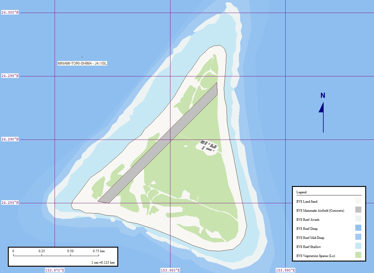
The island is triangular in shape, and has a saucer-like profile, with a raised outer rim of between 5 and 9 metres (16 and 30 ft) above sea level. The central area of the island is 1 m (3 ft) below sea level. Minami-Tori-Shima is surrounded by fringing reefs which ranges from 50 to 300 m (164–984 ft) in width, enclosing a shallow lagoon, which is connected with the open ocean by narrow passages on the southern and northeastern sides.
Outside the reef, the ocean depths quickly plunge to over 1,000 m (3,300 ft). The island has a total land area of 1.51 km2 (1 sq mi)).[1] It takes about 45 minutes to walk around the island.
The sea is clear in the shallow area around Minami-Tori-Shima. At night, there is no light pollution, so rarely-noticed stars are clearly visible in the sky.[2]
The island does not have soil adequate to produce substantial crops, so food is brought in by supply ships and planes. The only food grown on the island is papaya, mustard greens, and coconuts, and saltwater fish are caught offshore.[2]
Minami-Tori-Shima area rare earth deposits
After China restricted exports of strategic rare earth oxides (REO) in 2009 Japan started to explore its seabeds for deposits.[3]
In January 2013, a deep-sea research vessel of the Japan Agency for Marine-Earth Science and Technology obtained seven deep-sea mud core samples from the seafloor at 5,600 to 5,800 meters depth, approximately 250 kilometers (160 mi) south of the island.[4] The research team found a mud layer 2 to 4 metres (6.6 to 13.1 ft) beneath the seabed that is extremely concentrated in REO. Analytical results showed that the maximum REO content in the mud was up to 0.66% REO.[5][6]
In 2018 a scientific study of the seabed mud resulted in an estimate of 16 million tons of rare earth mineralised sediments within the studied area. The calculated rare-earth element and yttrium content for the research area was more than 16 million tons (average = 964ppm).[7][8]
Wildlife
A member of the gecko family Gekkonidae called Perochirus ateles inhabits the island. In Japan, these are only found in Minami-Tori-Shima and South Iwo Jima. They are thought to have arrived from Micronesia on driftwood.[citation needed]
There are also a large number of land snails called Achatina fulica with parasites which are harmful to humans. There are various forms of marine life in the ocean around the island. These include sea snakes, tuna, sharks, and some rare fish. Small fish are in the shallow area around the island.[2]
Population
There are no local residents on Minami-Tori-shima: Civilians are not allowed to reside there, and the personnel of the Japan Meteorological Agency, Japan Self-Defense Forces, and the Japan Coast Guard, only serve on the island for a limited period of time, and in limited numbers.[2]
History

First known sightings
The first discovery and mention of an island in this area was made by a Spanish Manila galleon captain, Andrés de Arriola in 1694.[9] It was charted in Spanish maps as Sebastián López, after Spanish Admiral Sebastián López, victorious in the battles of La Naval de Manila in 1646 against the Dutch. Its exact location was left unrecorded until further sightings in the 19th century.
Captain Bourn Russell (1794–1880) in the Lady Rowena departed Sydney, NSW, 2 November 1830 on a Pacific whaling voyage. On his return on 27 June 1832, he reported an island, not on his charts, which he named "William the Fourth's Island". The Sydney Herald reported Russell's description of the size, shape, and orientation of the island and its reef, but misspelled his name and gave the island a southern hemisphere latitude.[10]
The island was sighted again on 16 December 1864 by Captain Charles Gelett of the Hawaiian Evangelical Association's missionary ship Morning Star, and was called "Weeks Island" by him. Its position was recorded by a United States survey ship in 1874 and first sighted by a Japanese national, Kiozaemon Saito in 1879.[11][12][13]
Colonization and sovereignty contention
On 30 June 1886, a Japanese man named Shinroku Mizutani led a group of 46 colonists from Haha-jima in the Ogasawara Islands to settle on Marcus Island. The settlement was named "Mizutani" after the leader of the expedition. The Empire of Japan officially annexed the island 24 July 1898,[14] the previous United States claim from 1889 according to the Guano Islands Act not being officially acknowledged. The island was officially named "Minami-Tori-Shima" and placed administratively under the Ogasawara Subprefecture of Tokyo.[citation needed]
Sovereignty over the island before World War I was apparently disputed as various sources from the time move the island from the American to Japanese domain without specific explanation. In 1902, the United States dispatched a warship from Hawaii to enforce its claims but withdrew on finding the island still inhabited by Japanese, with a Japanese warship patrolling nearby. In 1914, William D. Boyce included Marcus Island as an obviously American island in his book, The Colonies and Dependencies of the United States. In 1933, by orders of the Japanese government, the civilian inhabitants of Minami-Tori-Shima were evacuated. In 1935, the Imperial Japanese Navy established a meteorological station on the island and built an airstrip.[citation needed]
World War II

After the start of World War II the Japanese garrison stationed on the island consisted of the 742-man Minami-Tori-shima Guard Unit, under the command of Rear Admiral Masata Matsubara, and the 2,005-man 12th Independent Mixed Regiment of the Imperial Japanese Army, under the command of Colonel Yoshiichi Sakata.[15] The United States Navy bombed it repeatedly in 1942[16] and in 1943,[17] but never attempted to capture it (the island was featured in the U.S. film The Fighting Lady). Japan was able to resupply the garrison by submarine, using a channel, still visible today, cut through the reef on the northwest side of the island. The island was subject to repeated U.S. air attacks during World War II and finally surrendered when the destroyer USS Bagley arrived on 31 August 1945.[18]
U.S. occupation

The Treaty of San Francisco transferred the island to American control in 1952.[lower-alpha 1] The island was returned to Japanese control in 1968, but the Americans retained control of the airstrip and LORAN station.[citation needed]
In 1964, after some delays caused by storms that ravaged the island during construction, the U.S. Coast Guard opened a LORAN-C navigation station on Minami-Tori-Shima, whose mast was until 1985 one of the tallest structures in the Pacific area at 1,350 feet (411 m). Before replacing Loran A for general marine navigation, Loran C was used by submarine-launched Polaris missile systems and the existence and location of Loran C stations was classified. LORANSTA Marcus Island was billeted for 23 U.S. Coast Guard personnel. The commissioning commanding officer was U.S. Coast Guard Lieutenant Commander Louis. C. Snell. A detachment of SeaBees remained on the island for several months making repairs to the island's airstrip.[citation needed]
The island is extremely isolated. Coast guardsmen stationed on the island served one-year tours that were later modified to allow an R&R visit to mainland Japan at the six-month point. At the end of this isolated tour of duty, crew members received an additional 30 days of compensatory leave.[citation needed]
While under U.S. administration, a C-130 Hercules from the 345th Tactical Airlift Squadron, Yokota Air Base, Japan, resupplied the island on weekly missions every Thursday. Coast guardsmen often amused themselves by judging aircraft landings, raising placards painted with large numbers. An unusually long four-hour ground time was scheduled to allow technicians who flew in to perform maintenance on the transmitter and to offload extra fuel from the C-130 to power the island's generator. It also allowed the coast guardsmen to read and answer letters while aircrews snorkeled and collected green glass fishing buoys that had washed up on the shore. During the Vietnam war era, the weekly log flight was a DC-6 flight conducted by the CIA-operated "Air America.”[citation needed]
Resumed Japanese administration
The Marcus Island station was transferred from the U.S. Coast Guard to the Japan Maritime Self Defense Force (JMSDF) on 30 September 1993 and was closed on 1 December 2009.[citation needed]
The island is currently used for weather observation and has a radio station, but little else. The JMSDF garrison was supplied by C-130s from Iruma Air Base, or by C-130s from Haneda or Atsugi Air Base with flights via Iwo Jima on a weekly basis. The runway of Minami Torishima Airport is only 1,300 meters (4,300 ft) long and cannot handle large aircraft.[citation needed]
Climate
Minami-Tori-shima has a tropical savanna climate (Köppen climate classification Aw), with warm to hot temperatures throughout the year. The wettest months are July and August, while the driest months are February and March. It has the highest average temperature in Japan of 25 °C (77 °F).[19]
| Climate data for Minami-Torishima (1991−2020 normals, extremes 1951−present) | |||||||||||||
|---|---|---|---|---|---|---|---|---|---|---|---|---|---|
| Month | Jan | Feb | Mar | Apr | May | Jun | Jul | Aug | Sep | Oct | Nov | Dec | Year |
| Record high °C (°F) | 29.7 (85.5) |
29.0 (84.2) |
30.2 (86.4) |
31.9 (89.4) |
34.0 (93.2) |
35.0 (95.0) |
35.6 (96.1) |
34.7 (94.5) |
35.3 (95.5) |
33.5 (92.3) |
34.2 (93.6) |
31.6 (88.9) |
35.6 (96.1) |
| Average high °C (°F) | 24.6 (76.3) |
24.3 (75.7) |
25.3 (77.5) |
27.1 (80.8) |
29.0 (84.2) |
31.0 (87.8) |
31.3 (88.3) |
31.0 (87.8) |
30.9 (87.6) |
30.2 (86.4) |
28.7 (83.7) |
26.7 (80.1) |
28.3 (82.9) |
| Daily mean °C (°F) | 22.4 (72.3) |
21.8 (71.2) |
22.5 (72.5) |
24.3 (75.7) |
26.1 (79.0) |
28.0 (82.4) |
28.5 (83.3) |
28.4 (83.1) |
28.5 (83.3) |
27.9 (82.2) |
26.5 (79.7) |
24.5 (76.1) |
25.8 (78.4) |
| Average low °C (°F) | 20.3 (68.5) |
19.6 (67.3) |
20.4 (68.7) |
22.3 (72.1) |
24.1 (75.4) |
25.8 (78.4) |
26.1 (79.0) |
26.1 (79.0) |
26.4 (79.5) |
25.9 (78.6) |
24.7 (76.5) |
22.6 (72.7) |
23.7 (74.7) |
| Record low °C (°F) | 13.9 (57.0) |
13.8 (56.8) |
14.2 (57.6) |
16.4 (61.5) |
19.1 (66.4) |
20.0 (68.0) |
21.6 (70.9) |
21.8 (71.2) |
21.7 (71.1) |
20.8 (69.4) |
19.2 (66.6) |
16.7 (62.1) |
13.8 (56.8) |
| Average precipitation mm (inches) | 69.7 (2.74) |
43.4 (1.71) |
56.0 (2.20) |
59.6 (2.35) |
100.6 (3.96) |
44.3 (1.74) |
139.8 (5.50) |
177.1 (6.97) |
94.8 (3.73) |
89.6 (3.53) |
83.0 (3.27) |
90.8 (3.57) |
1,052.8 (41.45) |
| Average snowfall cm (inches) | 0 (0) |
0 (0) |
0 (0) |
0 (0) |
0 (0) |
0 (0) |
0 (0) |
0 (0) |
0 (0) |
0 (0) |
0 (0) |
0 (0) |
0 (0) |
| Average precipitation days (≥ 0.5 mm) | 10.9 | 8.5 | 8.1 | 7.8 | 9.3 | 7.2 | 14.8 | 16.7 | 14.1 | 12.7 | 10.4 | 11.8 | 132.7 |
| Average relative humidity (%) | 70 | 70 | 74 | 79 | 79 | 77 | 77 | 79 | 79 | 78 | 76 | 74 | 76 |
| Mean monthly sunshine hours | 170.8 | 179.4 | 222.3 | 240.2 | 275.1 | 311.2 | 276.3 | 248.1 | 254.6 | 250.8 | 211.0 | 182.3 | 2,821.7 |
| Source: Japan Meteorological Agency[20] | |||||||||||||
See also
- Geography of Japan
- Japanese Archipelago
- List of extreme points of Japan
- Imperial Japanese Navy Land Forces
- List of reefs
Footnotes
- Article 3 of the Treaty of San Francisco: "Japan will concur in any proposal of the United States to the United Nations to place under its trusteeship system, with the United States as the sole administering authority, Nansei Shoto south of 29° north latitude (including the Ryukyu Islands and the Daito Islands), Nanpo Shoto south of Sofu Gan (including the Bonin Islands, Rosario Island and the Volcano Islands) and Parece Vela and Marcus Island. Pending the making of such a proposal and affirmative action thereon, the United States will have the right to exercise all and any powers of administration, legislation, and jurisdiction over the territory and inhabitants of these islands, including their territorial waters."
References
- 国土交通省 南鳥島の概要 [Overview of Minami-Tori-Shima. Ministry of Land, Infrastructure, Transport, and Tourism] (PDF).
- "Minamitorishima is the easternmost point in Japan. A large survey of the solitary islands of the sea!". Tokyo / Ogasawara Islands. Travelbook.co.jp. Archived from the original on 17 August 2019. Retrieved 17 August 2019.
- Jamasmie, Cecilia (25 March 2013). "Japan's massive rare earth discovery threatens China's supremacy". Mining.com. Retrieved 16 April 2018.
- "Seabed offers brighter hope in rare-earth hunt". Nikkei Asian Review. Nikkei Inc. 25 November 2014. Retrieved 11 December 2016.
- "Discovery of rare earths around Minami-Torishima". UTokyo Research. University of Tokyo. 2 May 2013. Retrieved 11 December 2016.
- Zhi Li, Ling; Yang, Xiaosheng (4 September 2014). China's rare earth ore deposits and beneficiation techniques (PDF). 1st European Rare Earth Resources Conference. Milos, Greece: European Commission for the 'Development of a sustainable exploitation scheme for Europe's Rare Earth ore deposits'. Retrieved 11 December 2016.
- Takaya, Yutaro; Yasukawa, Kazutaka; Kawasaki, Takehiro; Fujinaga, Koichiro; Ohta, Junichiro; Usui, Yoichi; et al. (2018). "The tremendous potential of deepsea mud as a source of rare-earth elements". Scientific Reports. 8 (1): 5763. Bibcode:2018NatSR...8.5763T. doi:10.1038/s41598-018-23948-5. PMC 5893572. PMID 29636486.
- Palin, Megan (18 April 2018). "'Game changer': Discovery on tiny island could alter global economy". news.com.au. Retrieved 16 September 2019.
- Welsch, Bernhard (2001). "The Asserted Discovery of Minami-Tori-shima in 1694". Journal of Pacific History. 36 (1): 105–115. doi:10.1080/00223340120049479. S2CID 161496300.
- "[no title cited]". The Sydney Herald. NSW. 16 July 1832. p. 2B.
- he Nautical Magazine and Naval Chronicle for 1868. Cambridge University Press. 2013. p. 458. ISBN 9781108054881. Retrieved 12 May 2020.
- Hiraoka, Akitoshi (2012). Japanese Advance into the Pacific Ocean: The Albatross and the Great Bird Rush. Singapore: Springer Nature. p. 16. ISBN 9789811051401. Retrieved 12 May 2020.
- Stommel, Henry (21 June 2017). Lost Islands: The Story of Islands That Have Vanished from Nautical Charts. Mineola, NY: Dover Publications. p. 62. ISBN 9780486784670.
- Kuroda (1954) p. 87
- Takizawa, Akira; Alsleben, Allan (1999–2000). "Japanese garrisons on the by-passed Pacific Islands 1944-1945". Forgotten Campaign: The Dutch East Indies Campaign 1941-1942. Archived from the original on 6 January 2016.
- "The Raids on Wake and Marcus Islands". Early Raids in the Pacific Ocean. Office of Naval Intelligence. USN Combat Narrative series. United States Navy. 1943.
- Paramount Battles Involving Essex Class Carriers. Archived from the original on 15 May 2008.
- "Surrender at Marcus Island". 30 March 2015.
- "Japan". climate-charts.com. Archived from the original on 2017-10-30. Retrieved 2009-04-05.
- 気象庁 / 平年値(年・月ごとの値). Japan Meteorological Agency. Retrieved May 19, 2021.
Further reading
- Bryan, William A. (1903). A monograph of Marcus Island. Occasional Papers of the Bernice Pauahi Bishop Museum. Vol. 2.
- Kuroda, Nagahisa (1954). "Report on a trip to Marcus Island, with notes on the birds". Pacific Science. 8 (1).
- L, Klemen (1999–2000). "Forgotten Campaign: The Dutch East Indies Campaign 1941-1942". Archived from the original on 26 July 2011.
- Lévesque, Rodrigue (1997). "The Odyssey of Captain Arriola and His Discovery of Marcus Island in 1694". Journal of Pacific History. 32 (2): 229–233. doi:10.1080/00223349708572841.
- Pub 158 Japan. Vol. 1. Bethesda, Maryland: National Geospatial-Intelligence Agency. Archived from the original on 2007-11-03. Retrieved 2006-08-25.
- Sakagami, Shoichi F. (1961). "An ecological perspective of Marcus Island, with special reference to land animals". Pacific Science. 15 (1).
- Welsch, Bernhard (2001). "The Asserted Discovery of Marcus Island in 1694". Journal of Pacific History. 36 (1): 105–115. doi:10.1080/00223340120049479. S2CID 161496300.
- Welsch, Bernhard (2004). "Was Marcus Island discovered by Bernardo de la Torre in 1543?". Journal of Pacific History. 39 (1): 109–122. doi:10.1080/00223340410001684886. S2CID 219627973.
External links
- "Minami Torishima info and pictures". geocities. Archived from the original on 2009-10-19.[unreliable source?]
- "Marcus Island (Minami Tori Shima) – sunrise, sunset, tides".
- "Map and aerial photo of Minami Torishima". Geographical Survey Institute of Japan. Archived from the original on 2006-04-11. Retrieved 2006-03-29.
- "The island during the Pacific War (USS Shubrick DD 639)".
Authority control | |
|---|---|
| General |
|
| National libraries | |
На других языках
[de] Minami-Torishima
Die Minami-Torishima (jap. 南鳥島; wörtlich: „südliche Vogelinsel“), auch Marcusinsel (Marcus Island) genannt, ist eine japanische Koralleninsel im Pazifischen Ozean.- [en] Minami-Tori-shima
[es] Minami Torishima
Minami Torishima (南鳥島, Minami Torishima?) o Isla Marcus es una isla aislada localizada al noroeste del océano Pacífico. El significado en japonés es "Isla de los pájaros del sur". Posee un área de 1,2 km². Es el territorio más oriental de Japón a 1848 km al sudeste de Tokio, y a 1267 km al este de la isla japonesa más cercana, Minami Iōjima en las Islas Ogasawara, y forma una línea entre Tokio y la Isla Wake, que está a 1415 km al este-sudeste. La isla más cercana es Farallón de Pájaros en las Islas Marianas, que está a 1021 km al oeste-sudoeste.[fr] Minamitori-shima
L'île Minamitori ou Minamitori-shima (南鳥島, Minamitorishima?, littéralement « île des oiseaux du sud ») est une île du Japon située dans l'océan Pacifique nord et faisant partie de la sous-préfecture d'Ogasawara. Elle est cependant très isolée, à l'est de l'archipel Ogasawara.[it] Minami Torishima
Minami Torishima (南鳥島? letteralmente: isola meridionale dell'uccello, nota anche come isola Marcus) è un piccolo atollo giapponese disabitato dell'Oceano Pacifico occidentale. È situato 1.267 km ad est della più vicina isola giapponese, Minami Iwo Jima (Minami-iōtō), che fa parte dell'arcipelago delle Ogasawara, e 1.848 km a sud-est delle coste di Tokyo. La terra emersa più vicina è la piccola Maug Orientale delle isole Marianne, che si trova a 1.015 km in direzione ovest sud-ovest. È il punto più orientale del Giappone ed il solo territorio del paese situato ad est della fossa del Giappone.[ru] Минамитори
Минамитори (яп. 南鳥島 минамитори-сима) (или Маркус) — изолированный остров-атолл в северо-западной части Тихого океана. Площадь — 1,2 км². Ранее включался в состав архипелага Ансона. Административно входит в округ Огасавара в составе префектуры Токио.Другой контент может иметь иную лицензию. Перед использованием материалов сайта WikiSort.org внимательно изучите правила лицензирования конкретных элементов наполнения сайта.
WikiSort.org - проект по пересортировке и дополнению контента Википедии