geo.wikisort.org - Island
Iwo Jima (/ˌiːwoʊ ˈdʒiːmə/, also US: /ˌiːwə ˈ-/),[2][3][4][5] known in Japan as Iō Tō (硫黄島, Iō-tō, lit. 'sulfur island'),[6] is one of the Japanese Volcano Islands and lies south of the Bonin Islands. Together with other islands, they form the Ogasawara Archipelago. The highest point of Iwo Jima is Mount Suribachi at 169 m (554 ft) high.
Native name: 硫黄島 | |
|---|---|
 Photo of Iwo Jima (Iō-tō), c. 2016. Mount Suribachi is in the lower left hand corner. | |
 Iwo Jima | |
| Geography | |
| Location | Pacific Ocean |
| Coordinates | 24°46′48″N 141°19′12″E |
| Archipelago | Volcano Islands |
| Area | 21 km2 (8.1 sq mi) |
| Highest elevation | 169 m (554 ft) |
| Highest point | Mount Suribachi[1] |
| Administration | |
Japan | |
| Prefecture | Tokyo Metropolis |
| Subprefecture | Ogasawara Subprefecture |
| Village | Ogasawara |
| Demographics | |
| Population | No native population (military personnel only) |
Although 1,200 km (750 mi; 650 nmi) south of the metropolis of Tokyo on the mainland, this island of 21 km2 (8 square miles) is administered as part of the Ogasawara Subprefecture of Tokyo. Since July 1944, when all the civilians were forcibly evacuated, the island has had a military-only population.
The island was the location of the Battle of Iwo Jima between February 1945 and March 1945. This engagement saw some of the fiercest fighting of the Pacific War, with each side suffering over 20,000 casualties in the battle. The island became globally recognized when Joe Rosenthal, of the Associated Press, published his photograph Raising the Flag on Iwo Jima, taken on Mount Suribachi. The US military occupied Iwo Jima until 1968, when it was returned to Japan.
Name
The first European to arrive at Iwo Jima was Spanish sailor Bernardo de la Torre who named it Sufre Island, after the old Spanish term for sulphur (azufre in modern Spanish).[7] At that time Iwo Jima and other nearby islands represented boundaries between the Spanish and Portuguese Empires within the far East as the demarcation line of the Treaty of Zaragoza crossed the area.
In 1779, the island was charted as Sulphur Island, the literal translation of its official name, during Captain James Cook's third surveying voyage.[8] As reported in the December 1786 supplement to The New London Magazine :
“On the 14th [of October 1779], they discovered an island, about five miles long, lying in lat. 24d. 48m. long. 141d. 12m. On the south point of this is a high barren hill, which evidently presented a volcanic crater. The earth, rock, or sand (for it was not easy to distinguish of which its surface is composed) exhibited various colours; and a considerable part was conjectured to be sulphur, both from its appearance to the eye, and the strong sulphureous smell, perceived as they approached the point; and some thought they saw steams rising from the top of the hill. From these circumstances, Captain Gore gave it name of Sulphur Island.”[9]
The name "Sulphur Island" was translated into Late Middle Japanese with the Sino-Japanese rendering iwō-tō イヲウトウ (硫黄島, modern Japanese Iō-tō イオウトウ), from Middle Chinese ljuw-huang "sulfur" and táw "island". The historical spelling iwautau[10] had come to be pronounced (approximately) Iwō-tō by the age of Western exploration, and the 1946 orthography reform fixed the spelling and pronunciation at Iō-tō イオウトウ.
An alternative, Iwō-jima, modern Iō-jima, also appeared in nautical atlases.[11] (Tō and shima are different readings of the kanji for island (島), the shima being changed by rendaku to jima in this case.) Japanese naval officers who arrived to fortify the island before the U.S. invasion mistakenly called it Iwō-jima,[11] and in this way, the Iwo Jima reading became mainstream and was the one used by U.S. forces who arrived during World War II. Former island residents protested against this rendering, and the Ministry of Land, Infrastructure, Transport and Tourism's Geographical Survey Institute debated the issue and formally announced on June 18, 2007, that the official Japanese pronunciation of the island's name would revert to the pre-war Iō-tō.[6] Moves to revert the pronunciation were sparked by the high-profile films Flags of Our Fathers and Letters from Iwo Jima.[11] The change does not affect how the name is written with kanji, 硫黄島, only how it is pronounced or written in hiragana, katakana and rōmaji.
Geography


The island has an approximate area of 21 km2 (8 sq mi; 5,189 acres). The most prominent feature is Mount Suribachi on the southern tip, a vent that is thought to be dormant and is 161 m (528 ft) high.[1] Named after a Japanese grinding bowl, the summit of Mount Suribachi is the highest point on the island. Iwo Jima is unusually flat and featureless for a volcanic island. Suribachi is the only obvious volcanic feature, as the island is only the resurgent dome (raised centre) of a larger submerged volcanic caldera surrounding the island.[12] The island forms part of the Kazan-retto islands Important Bird Area (IBA), designated by BirdLife International.[13]
80 km (43 nautical miles, 50 mi) north of the island is North Iwo Jima (北硫黄島, Kita-Iō-tō, literally: "North Sulfur Island") and 59 km (37 mi; 32 nmi) south is South Iwo Jima (南硫黄島, Minami-Iō-tō, "South Sulfur Island"); these three islands make up the Volcano Islands group of the Ogasawara Islands. Just south of Minami-Iō-jima are the Mariana Islands.
The visible island stands on a plateau (probably made by wave erosion) at depth about 15 m, which is the top of an underwater mountain 1.5 km to 2 km tall and 40 km diameter at base.[14]
Eruption history
Iwo Jima has a history of minor volcanic activity a few times per year (fumaroles, and their resultant discolored patches of seawater nearby).[15] In November 2015 Iwo Jima was placed first in a list of ten dangerous volcanoes, with volcanologists saying there was a one in three chance of a large eruption from one of the ten this century.[16][17][18]
Prehistoric
- Earlier: An undersea volcano started, and built up into a volcanic island. It was truncated, either by caldera-forming eruption or by sea erosion.[19]
- About 760±20 BC: a large eruption with pyroclastic flows and lava destroyed a previous forested island[19]
- 131±20BC and 31±20 BC: carbon-14 date of seashells found buried in lava at Motoyama (see map)[19]
Witnessed
- October 1543: The first recorded sighting by Europeans, by Spanish navigator Bernardo de la Torre when trying to return from Sarangani to New Spain. Iwo Jima was charted as Sufre, the old Spanish term for sulphur.
- 15 November 1779: Captain James Cook's surveying crew saw a beach which by 2015 was 40 m (131 ft) above sea level due to volcanic uplifting.[12] (By then Captain Cook had died and his expedition was led by James King and John Gore.) Such uplifting occurs on the island at a varying rate of between 100 and 800 mm (3.9 and 31.5 in) per year, with an average rate of 200 mm (8 in) per year.[20]
- Early 1945: United States armed forces landed on a beach which by 2015 was 17 m (56 ft) above sea level due to volcanic uplift.[21]
- 28 March 1957: A phreatic eruption occurred without warning 2 km northeast of Suribachi, lasting 65 minutes and ejecting material 30 m (100 feet) high from one crater. Another crater, 30 m (100 feet) wide and 15 m (50 feet) deep, formed by collapse 50 minutes after the eruption ended.
- 9–10 March 1982: Five phreatic eruptions occurred from vents on the northwest shore of the island.[citation needed]
- 21 September 2001: A submarine eruption began from three vents southeast of Iwo-jima. It built a 10 m (33 feet) diameter pyroclastic cone.[22]
- October 2001: A small phreatic eruption at Idogahama (a beach on the northwest coast of the island) made a crater 10 m (33 feet) wide and 2–3 m deep.[22]
- May 2012: Fumaroles, and discolored patches of seawater were seen northeast of the island, indicating further submarine activity.[22]
- May to June 2013: Series of smaller volcanic earthquakes.[23]
- April 2018: A number of volcanic earthquakes, high white plumes up to 700 m.[24]
- 30 October to 5 November 2019: Volcanic quakes and subaerial eruption.[25]
- 29 April to 5 May 2020: Subaerial eruption and volcanic plume rising up to 1 km in height.[26]
- 8 September to 6 October 2020: Volcanic plume up to 1 km in height and a minor eruption.[27][28]
- 24 November 2021: Small phreatic eruption occurred with the ash plume height yet to be known.[29]
Volcanological external links
- 6 cross sections of stages in the c. 760±20 BC eruption
- SW-NE geological cross section through Suribachiyama
Climate
Iwo Jima has a tropical climate (Af) with long hot summers and warm winters with mild nights.
| Climate data for Iwo Jima | |||||||||||||
|---|---|---|---|---|---|---|---|---|---|---|---|---|---|
| Month | Jan | Feb | Mar | Apr | May | Jun | Jul | Aug | Sep | Oct | Nov | Dec | Year |
| Average high °C (°F) | 22 (71) |
22 (71) |
23 (73) |
26 (78) |
28 (82) |
29 (85) |
30 (86) |
30 (86) |
30 (86) |
29 (84) |
27 (80) |
24 (75) |
27 (80) |
| Average low °C (°F) | 17 (63) |
17 (63) |
18 (65) |
21 (69) |
23 (74) |
25 (77) |
26 (78) |
26 (78) |
26 (78) |
24 (76) |
23 (73) |
19 (67) |
22 (72) |
| Average precipitation mm (inches) | 7.6 (0.3) |
7.6 (0.3) |
46 (1.8) |
110 (4.2) |
110 (4.4) |
99 (3.9) |
180 (7.1) |
170 (6.6) |
110 (4.4) |
170 (6.6) |
120 (4.9) |
110 (4.5) |
1,380 (54.4) |
| [citation needed] | |||||||||||||
History
Pre-1945
The island was first visited by a westerner in October 1543, by Spanish sailor Bernardo de la Torre on board the carrack San Juan de Letrán when trying to return from Sarangani to New Spain.[30]
In the late 16th century, the island was discovered by the Japanese.[31]
Before World War II Iwo Jima was administered as Iōjima village and was (and is today) part of Tokyo. A census in June 1943 reported an island civilian population of 1,018 (533 males, 485 females) in 192 households in six settlements. The island had a primary school, a Shinto shrine, and one police officer; it was serviced by a mail ship from Haha-jima once a month, and by Nippon Yusen ship once every two months. The island's economy relied upon sulfur mining, sugarcane farming, and fishing; an isolated island in the middle of the Pacific Ocean with poor economic prospects, Iwo Jima had to import all rice and consumer goods from the Home Islands.[citation needed]
Even before the beginning of World War II, there was a garrison of the Imperial Japanese Navy at the southern part of Iwo Jima. It was off-limits to the island's civilian population, who already had little contact with the naval personnel, except for trading.

Throughout 1944, Japan conducted a massive military buildup on Iwo Jima in anticipation of a U.S. invasion. In July 1944, the island's civilian population was forcibly evacuated, and no civilians have permanently settled on the island since.
Battle of Iwo Jima
The American invasion of Iwo Jima began on February 19, 1945, and continued to March 26, 1945. The battle was a major initiative of the Pacific Campaign of World War II. The Marine invasion, known as "Operation Detachment", was charged with the mission of capturing the airfields on the island for use by P-51 fighters, and rescue of damaged heavy bombers that were not able to reach their main bases at Guam and Saipan; until then Japanese warplanes from there had harried U.S. bombing missions to Tokyo.
The battle was marked by some of the fiercest fighting of the war. The Imperial Japanese Army positions on the island were heavily fortified, with vast bunkers, hidden artillery, and 18 kilometres (11 mi) of tunnels.[32][33] The battle was the first U.S. attack on the Japanese Home Islands and the Imperial soldiers defended their positions tenaciously. Of the 21,000 Japanese soldiers present at the beginning of the battle, over 19,000 were killed and only 1,083 taken prisoner.[34]
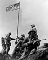
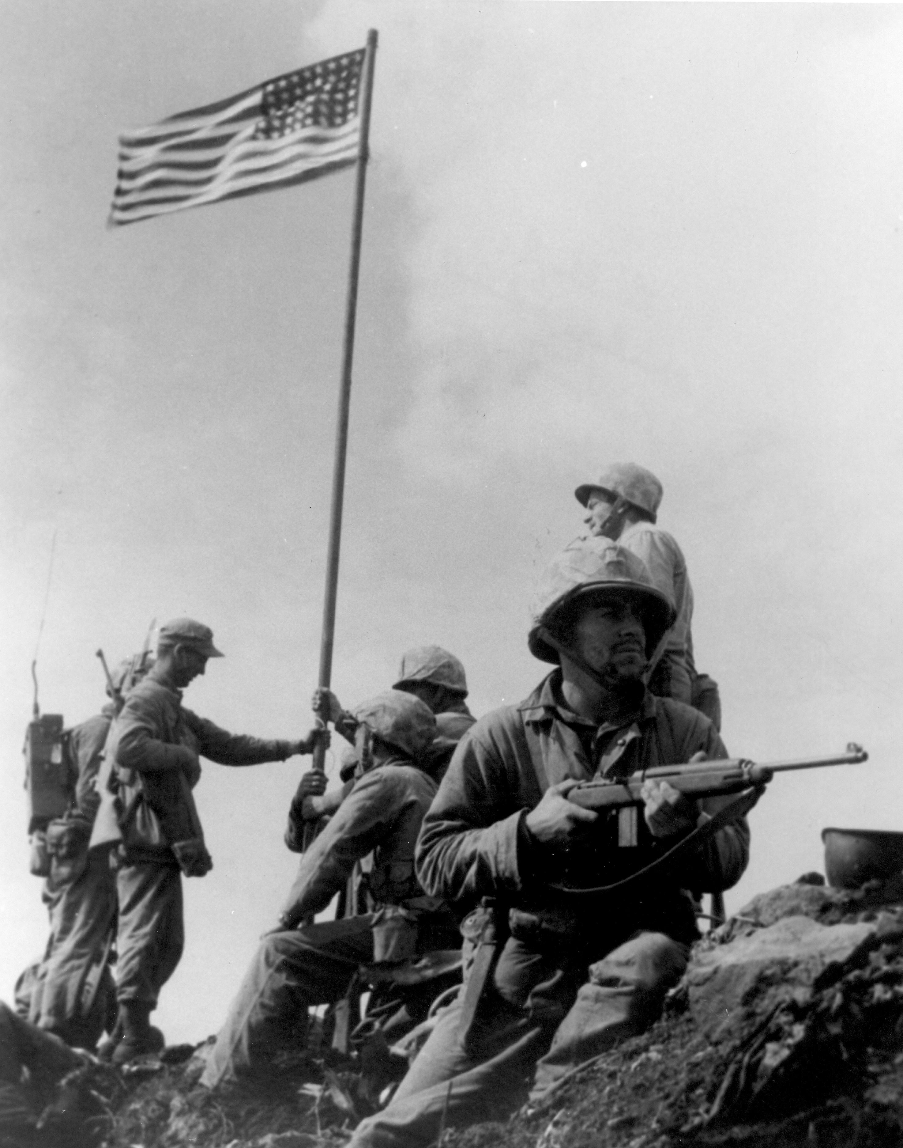
One of the first objectives after landing on the beachhead was the taking of Mount Suribachi. At the second raising of a flag on the peak, Joe Rosenthal photographed six Marines raising the United States flag on the fourth day of the battle (February 23).

The photograph was extremely popular, and won the Pulitzer Prize for Photography that same year. It is regarded as one of the most significant and recognizable images of the war.[1][35]
After the fall of Mount Suribachi in the south, the Japanese still held a strong position throughout the island. General Tadamichi Kuribayashi still had the equivalent of eight infantry battalions, a tank regiment, two artillery, and three heavy mortar battalions, plus the 5,000 gunners and naval infantry. With the landing area secure, more troops and heavy equipment came ashore and the invasion proceeded north to capture the airfields and the remainder of the island. Most Japanese soldiers fought to the death. On the night of March 25, a 300-man Japanese force launched a final counterattack led by Kuribayashi. The island was officially declared "secured" the following morning.
According to the U.S. Navy, "The 36-day (Iwo Jima) assault resulted in more than 26,000 American casualties, including 6,800 dead."[36] Comparatively, the 82-day Battle of Okinawa lasted from early April until mid-June 1945 and U.S. (five Army, two Marine Corps Divisions and Navy personnel on ships) casualties were over 62,000 of whom over 12,000 were killed or missing, while the Battle of the Bulge lasted 40 days (16 December 1944 – 25 January 1945) with almost 90,000 U.S. casualties comprising 19,000 killed, 47,500 wounded and 23,000 captured or missing.
After Iwo Jima was declared secured, about 3,000 Japanese soldiers were left alive in the island's warren of caves and tunnels. Those who could not bring themselves to commit suicide hid in the caves during the day and came out at night to prowl for provisions. Some did eventually surrender and were surprised that the Americans often received them with compassion – offering them water, cigarettes, or coffee.[37] The last of these stragglers, two of Lieutenant Toshihiko Ohno's men (Ohno's body was never found), Kōfuku Yamakage and Rikio Matsudo, lasted three and a half years, surrendering on January 6, 1949.[38][39]
The U.S. military occupied Iwo Jima until June 26, 1968, when it was returned to Japan.[40]
In memory of the battle, three ships of the U.S. Navy have been named USS Iwo Jima:
- USS Iwo Jima (CV-46), a planned Essex-class aircraft carrier which began construction in early 1945, but cancelled in August 1945 with the end of the war. It was eventually scrapped in 1949.
- USS Iwo Jima (LPH-2), the lead ship of the Iwo Jima-class amphibious assault ships, served from 1961 to 1993, and scrapped in 1995.
- USS Iwo Jima (LHD-7), a Wasp-class amphibious assault ship, commissioned in 2001 and in active service as of 2022[update].
Reunion of Honor
On February 19, 1985, the 40th anniversary of the day that U.S. forces began the assault on the island, veterans from both forces gathered for the Reunion of Honor just a few meters/yards away from the spot where U.S. Marines had landed on the island.[41] During the memorial service a granite plaque was unveiled with the message:
On the 40th anniversary of the battle of Iwo Jima, American and Japanese veterans met again on these same sands, this time in peace and friendship. We commemorate our comrades, living and dead, who fought here with bravery and honor, and we pray together that our sacrifices on Iwo Jima will always be remembered and never be repeated.
It is inscribed on both sides of the plaque, with the English translation facing the beaches where U.S. forces landed and the Japanese translation facing inland, where Japanese troops defended their position.
After that, the Japan–U.S. combination memorial service of the 50th anniversary was held in front of this monument in March 1995. The 55th anniversary was held in 2000, followed by a 60th reunion in March 2005 (see U.S. National Park Service photo below), and a 70th anniversary ceremony on March 21, 2015.[42]
A memorial service held on the island in 2007 got particular attention because it coincided with the release of the movie Letters from Iwo Jima. The joint U.S.–Japanese ceremony was attended by Yoshitaka Shindo, a Japanese lawmaker who is the grandson of the Japanese commander during the battle, Lt. Gen. Tadamichi Kuribayashi, and Yasunori Nishi, the son of Colonel Baron Takeichi Nishi, the Olympic gold medalist equestrian who died commanding a tank unit on the island.[43]
Active Marines have also visited the island on occasion for Professional Military Education (PME).[44]
 Raising of the first U.S. flag at Iwo Jima
 Raising of the second U.S. flag at Iwo Jima
 60th Reunion 2005
 Reunion of Honor Memorial


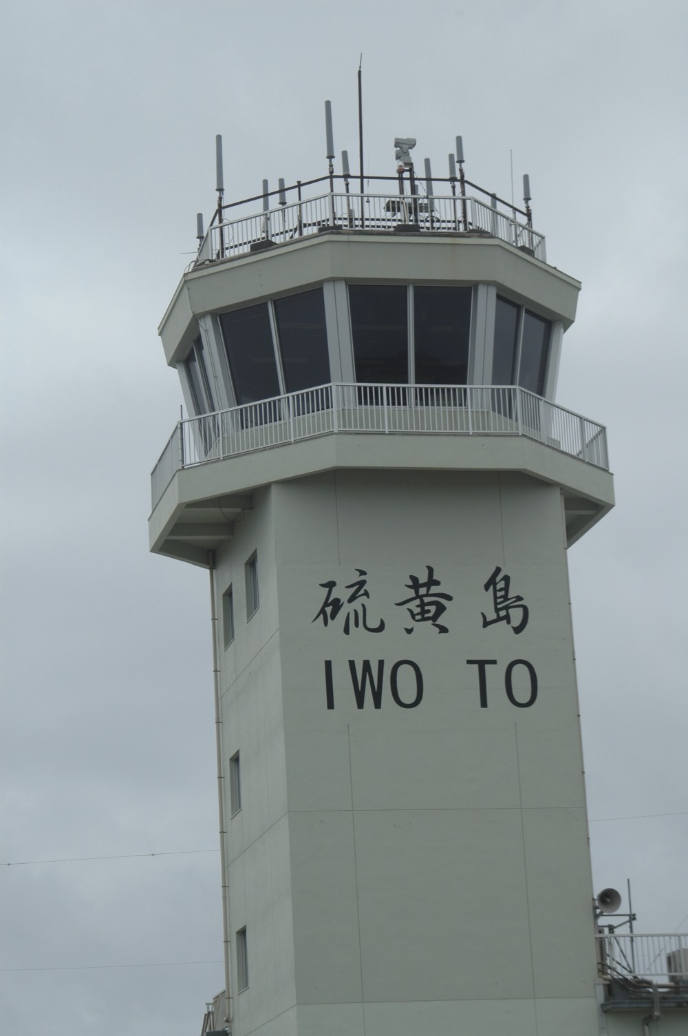
Japanese military base
The Japan Maritime Self-Defense Force (JMSDF) operates a naval air base on the island at Central Field.[45] The airstrip is 2,650 meters (8,700 ft) long and 60 meters (200 ft) wide. The JMSDF is in charge of support, air traffic control, fueling, and rescue. The airstrip is occasionally used for emergency landings by commercial airplanes flying transpacific routes. The IATA airport code of IWO and the ICAO airport code of RJAW are assigned to the airfield. The Japan Air Self-Defense Force also uses the base. The Japan Ground Self-Defense Force is in charge of explosive ordnance disposal, and maintains a garrison of 400 troops on the island.[11] Two abandoned airfields from World War II are nearby, North Field to the north of the current air base, and an unfinished Japanese airfield to the south of the base, which was improved after the U.S. invasion of the island.[citation needed]
The U.S. Navy's Carrier Air Wing Five, based at the United States Naval Air Facility Atsugi when not deployed aboard USS Ronald Reagan, also uses the base for field carrier landing practice (FCLP). The U.S. Navy still has a 1,639 acres (663 ha) disused communication facility (Iwo-Jima Communication Site) on the island, while the U.S. Coast Guard's Iwo Jima LORAN-C transmitter facility was transferred to Japan in 1993 and demolished in 1994.
Civilian access to the island is restricted to those attending memorial services for U.S. and Japanese fallen soldiers, construction workers for the naval air base, and meteorological agency officials. The Japanese troops stationed on the island register their residential addresses in Ayase, Kanagawa or Sayama, Saitama for voting, tax, and social security purposes. Officially, there is no population on the island.
U.S. nuclear arms base
Iwo Jima is claimed to be one of a number of Japanese islands which has been used by the United States to host nuclear arms, according to Robert S. Norris, William M. Arkin, and William Burr writing for the Bulletin of the Atomic Scientists in early 2000.[46][47] This is despite a Japanese policy of not allowing nuclear weapons on Japanese soil. Whether the site is used for this purpose is unknown, as great secrecy surrounds the United States' siting of nuclear arms bases; but on December 12, 1999, U.S. Under Secretary for Defense Policy Walter Slocombe told The New York Times, "Our position is that there have been no violations of our obligations under the security treaty and related arrangements."[48]
Norris, Arkin and Burr concluded however:
There were nuclear weapons on Chichi Jima and Iwo Jima (Iwo To), an enormous and varied nuclear arsenal on Okinawa, nuclear bombs (without their fission cores) stored on the mainland at Misawa and Itazuke airbases (and possibly at Atsugi, Iwakuni, Johnson, and Komaki airbases as well), and nuclear-armed U.S. Navy ships stationed in Sasebo and Yokosuka. ... Chichi Jima, Iwo Jima, and Okinawa were under U.S. occupation, that the bombs stored on the mainland lacked their plutonium and/ or uranium cores, and that the nuclear-armed ships were a legal inch away from Japanese soil. All in all, this elaborate stratagem maintained the technicality that the United States had no nuclear weapons "in Japan."[48]
See also
- List of volcanoes in Japan
- List of islands
- Desert island
- Naval Base Iwo Jima
References
- "Kikai". Global Volcanism Program. Smithsonian Institution. Retrieved 2021-06-24.
- "Iwo Jima". Merriam-Webster Dictionary. Retrieved 4 June 2019.
- "Iwo Jima". The American Heritage Dictionary of the English Language (5th ed.). HarperCollins. Retrieved 5 June 2019.
- "Iwo Jima". Collins English Dictionary. HarperCollins. Archived from the original on 4 June 2019. Retrieved 4 June 2019.
- "Iwo Jima" Archived 2019-06-04 at the Wayback Machine (US) and "Iwo Jima". Lexico UK English Dictionary. Oxford University Press. Archived from the original on 2020-08-18.
- 地名等の統一に関する連絡協議会 硫黄島の呼称を「いおうじま」から「いおうとう」へ変更 (in Japanese). Geographical Survey Institute of Japan. 2007-06-18. Archived from the original on 2012-02-07. Retrieved 2007-06-20.
- Welsch, Bernard (Jun 2004). "Was Marcus Island Discovered by Bernardo de la Torre in 1543?". The Journal of Pacific History. Taylor & Francis. Ltd. 39 (1): 114, 115. doi:10.1080/00223340410001684886. S2CID 219627973.
- Patrick, John M. Iwo Jima – Sulphur Island. United States Naval Institute Proceedings 76, no. 9 (September 1950): 1028-1029.
- “Captain Cook’s third and last Voyage to the Pacific Ocean”, The New London Magazine, Supplement to Vol.II, No.2, December 1786, p.697.
- Kōjien dai rokuban (Japanese dictionary). Iwanami shoten, 2008.
- Greimel, Hans; Lily Hindy (June 20, 2007). "Japan changes name of Iwo Jima". USA Today. Archived from the original on 2007-10-29. Retrieved 2007-06-24.
- "Ioto". Global Volcanism Program. Smithsonian Institution. Retrieved 2021-07-15.
- "Kazan-retto islands". BirdLife Data Zone. BirdLife International. 2021. Archived from the original on 16 August 2021. Retrieved 28 January 2021.
- "Iwo Jima in 45 eruptions". 12 October 2018. Archived from the original on 30 March 2019. Retrieved 30 March 2019.
- kaiho.mlit.go.jp Archived 2011-05-24 at the Wayback Machine (in Japanese)
- "World's 10 most dangerous volcanoes identified". University of Manchester. 13 November 2015. Archived from the original on 2016-10-23. Retrieved 2016-10-23.
'"The last time such a list was made was 25 years ago and that list mainly included volcanoes that are accessible to study in developed countries. Our new list looks all over the world, including in less developed countries. We have created this list to try to highlight the need for better monitoring and preparedness in many areas of the world. There hasn't been a major eruption for 200 years, since Tambora in 1815 ("the year without summer"), and there has never been a large eruption in a modern, developed country. There is a chance of perhaps 1 in 3 that there will such an eruption this century. "'
- Imster, Eleanor (November 18, 2015). "Top 10 most dangerous volcanoes". EarthSky.org. Archived from the original on 2016-04-09. Retrieved 2016-10-23.
- Whitfield, Tony (13 November 2015). "World's most dangerous volcano is named - and scientists fear it could unleash deadly tsunami when it blows". Daily Mirror. Archived from the original on 2016-10-25. Retrieved 2016-10-23.
- Carbon14 dating of buried charcoal: see https://www.volcanocafe.org/iwo-jima-in-45-eruptions/ Archived 2019-03-30 at the Wayback Machine , which see for more information about old eruptions.
- US Geophysics Research Forum, Geophysic Study Committee. Active Tectonics, p. 104. Archived August 26, 2016, at the Wayback Machine National Academies Press, 1986. ISBN 0-309-03638-0
- Carllestrange (June 30, 2013). "Brimstone over Iwo Jima!". VolcanoCafé. Archived from the original on December 21, 2016. Retrieved May 28, 2017.
- "Iwo-jima volcano eruptions". VolcanoDiscovery.com. Archived from the original on 2016-08-16. Retrieved 2016-06-10.
- Sennert, Sally Kuhn. "Global Volcanism Program | Report on Kikai (Japan) — 29 May-4 June 2013". volcano.si.edu. Smithsonian Institution and US Geological Survey Weekly Volcanic Activity Report, 29 May-4 June 2013. Archived from the original on 2 February 2021. Retrieved 2021-01-29.
- "Global Volcanism Program | Report on Kikai (Japan) — 25 April-1 May 2018". volcano.si.edu. Smithsonian Institution and US Geological Survey Weekly Volcanic Activity Report, 25 April-1 May 2018. Archived from the original on 2 February 2021. Retrieved 2021-01-29.
- "Global Volcanism Program | Report on Kikai (Japan) — 30 October-5 November 2019". volcano.si.edu. Archived from the original on 2021-03-30. Retrieved 2021-01-29.
- "Global Volcanism Program | Report on Kikai (Japan) — 29 April-5 May 2020". volcano.si.edu. Archived from the original on 2021-04-01. Retrieved 2021-01-29.
- "Global Volcanism Program | Report on Kikai (Japan) — 8 September-14 September 2020". volcano.si.edu. Archived from the original on 2021-02-07. Retrieved 2021-01-29.
- "Global Volcanism Program | Report on Kikai (Japan) — 30 September-6 October 2020". volcano.si.edu. Archived from the original on 2021-02-02. Retrieved 2021-01-29.
- "Iwo-jima volcano (Japan): small phreatic explosion". www.volcanodiscovery.com. Archived from the original on 2021-11-28. Retrieved 2021-11-28.
- Brand, Donald D. The Pacific Basin: A History of its Geographical Explorations The American Geographical Society (New York, 1967) p. 123.
- Schellinger, Paul; Salkin, Robert, eds. (1996). International Dictionary of Historic Places, Volume5: Asia and Oceania. Chicago: Fitzroy Dearborn Publishers. p. 379. ISBN 1-884964-04-4.
- Letters From Iwo Jima Archived December 12, 2007, at the Wayback Machine World War II Multimedia Database
- Japanese Defense of Iwo Jima Archived April 17, 2016, at the Wayback Machine
- Morison, Samuel Eliot (2002) [1960]. Victory in the Pacific, 1945, vol. 14 of History of United States Naval Operations in World War II. Urbana, IL: University of Illinois Press. ISBN 0-252-07065-8. OCLC 49784806.
- Fifty Years Later, Iwo Jima Photographer Fights His Own Battle Archived September 5, 2007, at the Wayback Machine
- history.navy.mil
- Toland, John (1970). The Rising Sun: The Decline and Fall of the Japanese Empire 1936-1945. New York: Random House. p. 731. OCLC 105915.
- "Japanese Surrender After Four Year Hiding". Pacific Stars and Stripes. Jan 10, 1949. p. 5. Archived from the original on July 17, 2013. Retrieved January 28, 2020.
- Cook, Donald. "Capture of Two Holdouts January 6, 1949". No Surrender: Japanese Holdouts. Archived from the original on 2007-10-09. Retrieved 2007-09-11.
- Schlueter, Roger (July 31, 2015). "U.S. returned hard-won islands to Japan to strengthen ties". Belleville News-Democrat. Archived from the original on November 14, 2019. Retrieved September 14, 2019.
- Boardman, Robert (January–February 1986). "A Higher Honor". Discipleship Journal. NavPress. Archived from the original on 2012-05-27. Retrieved 2007-06-20.
- Chacon, Joshua, Corporal, USMC (March 23, 2015). "70th Reunion of Honor". Defense Video Imagery Distribution System. United States Department Of Defense. Archived from the original on 2016-10-30. Retrieved 2016-10-29.
- Fackler, Martin (March 19, 2007). "Renewed Interest in Japanese Who Died in Epic Battle". The New York Times. Archived from the original on 2019-08-08. Retrieved 2019-08-08.
- Iwo Jima: Marines visit historical landmark Archived 2021-04-12 at the Wayback Machine Marine Corps Installations Pacific on YouTube
- Smith, Rex Alan (2002). Pacific legacy : image and memory from World War II in the Pacific. Gerald A. Meehl. New York: Abbeville Press. pp. 231, 236. ISBN 0-7892-0761-3. OCLC 49327054.
- Norris, Robert S.; William M. Arkin; William Burr (January–February 2000). "Where they were: how much did Japan know?". Bulletin of the Atomic Scientists. 56 (1): 11–13, 78–79. doi:10.2968/056001005. Retrieved 2009-07-20.[dead link]
- Norris, Robert S.; William M. Arkin; William Burr (November–December 1999). "NRDC: Nuclear Notebook: Appendix B: Deployments By Country, 1951-1977" (PDF). Bulletin of the Atomic Scientists. 55 (6): 66–67. doi:10.2968/055006019. Retrieved 2009-07-20.[dead link]
- "Allegations of Clandestine U.S. Nuclear Weapons in Japan". Disarmament Diplomacy. The Acronym Institute (42). December 1999. Archived from the original on 2007-09-27. Retrieved 2007-06-24.
External links
- Ioto - Japan Meteorological Agency (in Japanese)
- Ioto: National catalogue of the active volcanoes in Japan - Japan Meteorological Agency
- Io To - Geological Survey of Japan
- Iwo-jima volcano - volcanodiscovery
- Volcano Cafe report
Authority control | |
|---|---|
| General | |
| National libraries | |
| Other | |
На других языках
[de] Iwojima
Iwojima (japanisch 硫黄島, Iōtō .mw-parser-output .IPA a{text-decoration:none}[ioːtoː], auch Iōjima [ioːʑima], wörtlich: „Schwefelinsel“) ( anhören?/i) ist eine 23,73 km²[1] große Vulkaninsel im Pazifik, etwa 1200 Kilometer südlich von Tokio. Sie gehört zur Kazan-rettō der Ogasawara-Inseln.- [en] Iwo Jima
[es] Iōtō
Iōtō[1] (硫黄島, Iōtō[1]? literalmente, 'isla del azufre') o Iōjima o Iwo Tō (hasta 2007 se la llamaba comúnmente Iwo Jima) es una isla japonesa de origen volcánico que forma parte de las islas Vulcano (en el extremo sur del archipiélago Ogasawara), localizada a aproximadamente 1200 km (650 millas náuticas) al sur de Tokio.[2] Administrativamente forma parte de la subprefectura de Ogasawara en Tokio.[fr] Iwo Jima
Iōtō ou Iōjima (硫黄島?, littéralement « l'île du soufre ») .mw-parser-output .prononciation>a{background:url("//upload.wikimedia.org/wikipedia/commons/thumb/8/8a/Loudspeaker.svg/11px-Loudspeaker.svg.png")center left no-repeat;padding-left:15px;font-size:smaller}Écouter - plus connue pour des raisons historiques sous la transcription irrégulière Iwo Jima - est une île volcanique japonaise faisant partie de l'archipel d'Ogasawara (sous-préfecture d'Ogasawara), située en mer des Philippines à environ 1 046 km au sud de Tokyo (24,46° N, 141,18° E). Elle a une superficie d'environ 21 km2 et est étonnamment plate et peu accidentée. Son point culminant est le mont Suribachi, un volcan endormi qui culmine à 169 m d'altitude. Seule partie émergée d'une caldeira sub-océanique bien plus vaste, ce relief est l'unique trace évidente d'une activité passée. L'île est connue en raison de la bataille d'Iwo Jima durant la Seconde Guerre mondiale.[it] Iwo Jima
Iwo Jima (硫黄島 Iōjima?, dove -jima significa isola e iō, zolfo) è un'isola disabitata del Giappone, situata nella prefettura di Tokyo sebbene si trovi 1046 km a sud della capitale.[ru] Ио (Кадзан)
И́о[1] (Иото, Иодзима, в историческом контексте упоминается как Иводзима; яп. 硫黄島 (инф.), совр. いおうとう Ио: то:, устар. いおうじま Ио: дзима, «серный остров», англ. Iwo Jima) — остров вулканического происхождения, в 1200 км южнее Токио в архипелаге Кадзан, часто включаемом в Бонинские острова. Наибольшая протяжённость острова с севера на юг — 8 км, с запада на восток — 4 км. Протяжённость береговой линии — 22 км. Наивысшая точка — гора Сурибати (169 м), потухший вулкан. На Ио отсутствует постоянное население, но функционирует авиабаза Морских сил самообороны Японии.Другой контент может иметь иную лицензию. Перед использованием материалов сайта WikiSort.org внимательно изучите правила лицензирования конкретных элементов наполнения сайта.
WikiSort.org - проект по пересортировке и дополнению контента Википедии