geo.wikisort.org - Island
Maug (from the Chamorro name for the islands, Ma'ok, meaning "steadfast" or "everlasting") consists of a group of three small uninhabited islands. This island group is part of the Northern Islands Municipality of the Commonwealth of the Northern Mariana Islands, itself part of the Marianas archipelago in the Oceanian sub-region of Micronesia.
 US Geological survey photo of Maug islands | |
 | |
| Geography | |
|---|---|
| Location | Pacific Ocean |
| Coordinates | 20°2′N 145°13′E |
| Archipelago | Northern Mariana Islands |
| Area | 2.14 km2 (0.83 sq mi)[1] |
| Highest elevation | 227 m (745 ft) |
| Highest point | North Island |
| Administration | |
United States | |
| Commonwealth | Northern Mariana Islands |
| Demographics | |
| Population | - uninhabited - (2010) |
Geography

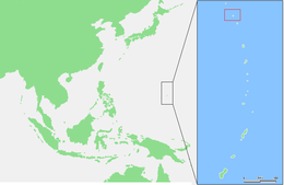
The Maug Islands lie about 70 kilometers (43 mi) south of Farallon de Pajaros and 37 km (23 mi) north of Asuncion. The archipelago consists of three islands, the eroded exposed outer rim of a submerged volcano with a caldera with a diameter of approximately 2.2 km (1.4 mi). The floor of the caldera is around 225 meters (738 ft) below sea level, and in the middle is a mountain whose summit is only 22 m (72 ft) below sea level. The total area of the islands combined is 2.13 square kilometers (0.82 sq mi), and the highest point is 227 m (745 ft) above sea level. About 10 km (6.2 mi) northwest of the Maug Islands is Supply Reef, a submarine volcano whose summit is 8 m (26 ft) below sea level. The Maug Islands and the Supply Reef are part of the same volcanic massif, and are connected by a saddle about 1,800 feet (550 m) below sea level.
| Island | Length (km) | Width (km) | Area (km²) | Height (m) |
|---|---|---|---|---|
| North Island | 1.5 | 0.5 | 0.47 | 227 |
| East Island | 2.25 | 0.5 | 0.95 | 215 |
| West Island | 2.0 | 0.75 | 0.71 | 178 |
| Maug Islands | 3.1 | 3.0 | 2.13 | 227 |
Environment
The islands are overgrown with savannah grass. On East Island are Pandanus trees and coconut palms (Cocos nucifera), near the former settlement.
Important Bird Area
The islands have been recognised as an Important Bird Area (IBA) by BirdLife International because they support populations of Micronesian megapodes, red-tailed tropicbirds, brown noddies, Micronesian myzomelas and Micronesian starlings.[2]
History
From a European perspective, the Maug Islands were discovered on 22 August 1522 by Gonzalo Gómez de Espinosa, who named it Las Monjas (The Nuns in Spanish). Gómez de Espinosa was a member of Ferdinand Magellan‘s attempted circumnavigation of the globe, and after Magellan’s death unsuccessfully attempted to navigate the ship Trinidad across the Pacific Ocean to Mexico. Gomez de Espinosa found the largest island of the Maug Islands settled by Chamorros, who called the island Mao or Pamo. Gómez de Espinosa freed the Chamorro whom he had kidnapped on Agrihan and three of his crewmen deserted the Trinidad on the island. Two of the deserters were killed by the Chamorros, but the third, Gonzalo Alvarez de Vigo, later came to Guam.[3] In 1669, the Spanish missionary Diego Luis de San Vitores visited the Maug Islands and named it San Lorenzo (St. Lawrence). In 1695, all of the inhabitants were forcibly deported to Saipan, and three years later, to Guam. Since that time, the islands have been uninhabited.[4]
Following the sale of the Northern Marianas by Spain to the German Empire in 1899, the Maug islands were administered as part of German New Guinea. In 1903, the island was leased to a Japanese company, who hunted birds for feathers for export to Japan, and from there to Paris.[5]
During World War I, the Maug Islands came under the control of the Empire of Japan and were subsequently administered as part of the South Seas Mandate. The Japanese established a weather station on the islands, and a fish processing plant. During World War II, the German auxiliary cruiser Orion rendezvoused with supply ships in January–February 1941 at the caldera of the Maug Islands.
Following World War II, the island came under the control of the United States and was administered as part of the Trust Territory of the Pacific Islands. Since 1978, the island has been part of the Northern Islands Municipality of the Commonwealth of the Northern Mariana Islands.
In 1985, per the Constitution of the Commonwealth of the Northern Mariana Islands, the islands were designated as a wilderness area for the protection and conservation of natural resources. Since 2009, the submerged lands and waters around the island have been part of Marianas Trench Marine National Monument of the United States.[6]
Gallery
 Perspective view of central cone within caldera. Colors indicate depth.
 Maug's East Island taken from USCGC Sequoia.
 Map including the Maug Islands (DMA, 1983)


See also
- List of stratovolcanoes
References
- "16 MAUG" (PDF). National Oceanic and Atmospheric Administration. p. 67. Archived (PDF) from the original on 15 November 2020. Retrieved 15 November 2020.
- "Maug Islands". BirdLife Data Zone. BirdLife International. 2021. Retrieved 8 February 2021.
- Robert F. Rogers: Destiny's landfall. A history of Guam. University of Hawai'i Press, Honolulu 1995, ISBN 0824816781, S. 10.
- Sharp, Andrew The discovery of the Pacific Islands, Clarendon Press, Oxford, 1960, p.11
- Gerd Hardach: König Kopra. Die Marianen unter deutscher Herrschaft 1899–1914. Steiner, Stuttgart 1990, ISBN 3515057625, S. 133f.
- Brainard, Coral reef ecosystem monitoring report, S. 4.
External links
| Wikimedia Commons has media related to Maug Islands. |
- Pascal Horst Lehne and Christoph Gäbler: Über die Marianen. Lehne-Verlag, Wohldorf in Germany 1972.
- "Maug Islands". Global Volcanism Program. Smithsonian Institution.
- Oceandots.com at the Wayback Machine (archived December 23, 2010)
Former German colonies and protectorates | ||||||
|---|---|---|---|---|---|---|
| Colonies |
| |||||
| Concessions |
| |||||
| Unrecognised |
| |||||
Saipan (capital) | |||||||||||
| Topics |
| ||||||||||
| Geography |
| ||||||||||
| Municipalities | |||||||||||
| Settlements |
| ||||||||||
| Education |
| ||||||||||
| Transportation | |||||||||||
| Landmarks |
| ||||||||||
| Media |
| ||||||||||
| Museums and History |
| ||||||||||
На других языках
[de] Maug Islands
Die Maug Islands (auch Maduch, Tunas, San Lorenzo oder Las Monjas)[1] sind eine kleine, unbewohnte Inselgruppe im Pazifischen Ozean. Sie gehören geographisch zum Archipel der Marianen und politisch zum Commonwealth der Nördlichen Marianen.- [en] Maug Islands
[es] Islas Maug
Las Islas Maug son tres islas deshabitadas pertenecientes al Municipio de las Islas del Norte, en Islas Marianas del Norte. Las tres islas son los puntos más altos de la caldera de un volcán sumergido. En el lugar en que estaría el pico del volcán hay una profunda y espaciosa bahía natural. Altos acantilados bordean las islas y el paisaje de las islas del Norte y el Oeste está dominado por columnas de basalto.[fr] Îles Maug
Les îles Maug sont un ensemble de trois petites îles situées dans le nord des îles Mariannes du Nord. Elles entourent la caldeira d'un ancien volcan. D'une superficie totale de 2,128 km2, elles sont très escarpées et inhabitées. La végétation est majoritairement constituée de prairies et de quelques cocotiers là où le terrain est plat. La caldeira a une profondeur moyenne de 200 mètres mais en son centre un dôme de lave culmine à 20 mètres en dessous des rebords de la caldeira.[it] Isole Maug
Le Isole Maug sono tre piccole isole disabitate dell'oceano Pacifico appartenenti alle Isole Marianne. Fanno parte della caldera di un vulcano sottomarino, il Supply Reef, posizionato circa 10 km a nordovest e collegato alle isole da una sella situata a circa 1800 metri di profondità.[1][ru] Мауг
Мауг (англ. Maug Islands) — группа островов в архипелаге Марианские острова в Тихом океане. Принадлежит Северным Марианским островам и входит в состав муниципалитета Северные острова.Другой контент может иметь иную лицензию. Перед использованием материалов сайта WikiSort.org внимательно изучите правила лицензирования конкретных элементов наполнения сайта.
WikiSort.org - проект по пересортировке и дополнению контента Википедии