geo.wikisort.org - Island
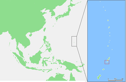
Aguiguan (also Aguigan and Aguihan, based on the Spanish rendition of the native name, Aguijan, which is still used) is a small bean-shaped coralline island in the Northern Mariana Islands chain in the Pacific Ocean. It is situated 8 kilometers (5.0 mi) south-west of Tinian, from which it is separated by the Tinian Channel. Aguiguan and neighboring Tinian Island together form Tinian Municipality, one of the four main political divisions that comprise the Northern Marianas.
 Satellite view, with Naftan Rock visible to the southwest | |
 | |
| Geography | |
|---|---|
| Location | Pacific Ocean |
| Coordinates | 14°51′13″N 145°33′34″E |
| Archipelago | Northern Mariana Islands |
| Area | 7.01 km2 (2.71 sq mi)[1] |
| Length | 4.7 km (2.92 mi) |
| Width | 1.8 km (1.12 mi) |
| Highest elevation | 157 m (515 ft) |
| Administration | |
United States | |
| Commonwealth | Northern Mariana Islands |
| Demographics | |
| Population | - uninhabited - (2010) |
History
This section needs additional citations for verification. (September 2022) |

It is likely that first sighting by Europeans occurred during the Spanish expedition of Ferdinand Magellan, or by its continuation by Gonzalo Gómez de Espinosa being charted as Santo Ángel. It was visited by the Spanish missionary Diego Luis de San Vitores in 1669.[2]
Aguiguan was administered as part of the Spanish Mariana Islands from the 16th century to 1899, when the Northern Marianas were sold by Spain to the German Empire. Under Germany, it administered as part of German New Guinea. During World War I, Aguiguan came under the control of the Empire of Japan and was administered as part of the South Seas Mandate. During World War II, the Imperial Japanese Army maintained a garrison on Aguigan. This garrison is noteworthy because of its surrender to Allied forces September 4, 1945, two days after the surrender of Japan on the USS Missouri (BB-63). The surrender was unique as it was the only surrender hosted by a U.S. Coast Guard Cutter, USCG 83525. US Navy Admiral Marshall R. Greer received the surrender of the Japanese Second Lieutenant Kinichi Yamada.[citation needed]
Following World War II, Aguiguan came under the control of the United States and was administered as part of the Trust Territory of the Pacific Islands. Since 1978, the island has been part of the Commonwealth of the Northern Mariana Islands.
Geography


Aguiguan is only 7.09 square kilometers (2.74 sq mi) in size, with a length of 4.7 km (2.9 mi) and a width of 1.8 km (1.1 mi). It is nicknamed “Goat Island” due to the large number of feral goats present there. Much of the native vegetation on Aguigan has been destroyed by goats.
Aguiguan is uninhabited and is seldom visited because it is surrounded by sheer steep cliffs. However, a 2002 survey of the island did find a handful of native species there, including the Mariana fruit bat, the Polynesian sheath-tailed bat and the Micronesian megapode Megapodius laperouse.
Naftan Rock
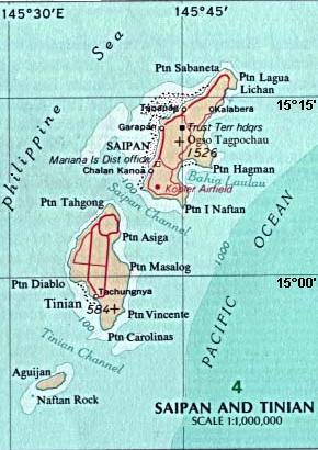
Approximately 1 kilometer (0.62 mi) off the south-west shore of Aguiguan is Naftan Rock, 18 meters (59 ft) in elevation.[3]
Important Bird Area
Aguigan and Naftan Rock have been recognised as an Important Bird Area (IBA) by BirdLife International because they support populations of Micronesian megapodes, white-throated ground doves, Mariana fruit doves, Mariana swiftlets, Micronesian myzomelas, rufous fantails, Aguiguan reed warblers, golden and Saipan white-eyes, and Micronesian starlings. Aguigan also supports seabird breeding colonies, with 120 pairs of brown boobies and 450 pairs of brown noddies reported, while Naftan Rock is home to several thousand seabirds. [4]
See also
- Tinian Naval Base
References
- Russell E. Brainard et al.: Coral reef ecosystem monitoring report of the Mariana Archipelago: 2003–2007, NOAA Fisheries, Pacific Islands Fisheries Science Center (2012).
References
- "6 AGUIJAN" (PDF). National Oceanic and Atmospheric Administration. p. 1. Archived (PDF) from the original on 15 November 2020. Retrieved 15 November 2020.
- Burney, James. A chronological history of the discoveries in the South Sea or Pacific Ocean London, 1803, vI, pg. 57.
- "Aguijan Optical Validation - NOAA Nautical Chart #8 1067". University of Hawaii. NOAA. Retrieved 20 October 2018.
- "Aguiguan Island and Naftan Rock". BirdLife Data Zone. BirdLife International. 2021. Retrieved 8 February 2021.
External links
- U.S. Coast Guard Historian's Office, Daily Chronology of Coast Guard History (Entry for 4 September)
- archive
- Pascal Horst Lehne and Christoph Gäbler: Über die Marianen. Lehne-Verlag, Wohldorf in Germany 1972. and Aguijan
- Google: Aguijan
From the website https://web.archive.org/web/20110728145947/http://www.uscg83footers.org/new_page_8.htm - Vessel corrected to be the Coast Guard Cutter 83525 Researched by Larry Richter, USCG Ret
Former German colonies and protectorates | ||||||
|---|---|---|---|---|---|---|
| Colonies |
| |||||
| Concessions |
| |||||
| Unrecognised |
| |||||

На других языках
[de] Aguijan
Aguijan (cham. Aguiguan) ist eine kleine Insel korallinen Ursprungs im Pazifischen Ozean. Sie gehört geographisch zum Inselbogen der Marianen und politisch zum Commonwealth der Nördlichen Marianen.- [en] Aguiguan
[es] Aguiján
Aguiján es una pequeña isla de las Islas Marianas del Norte situada a 8 km de Tinián, isla separada por el Canal de Tinian. Tiene 7,09 km ² (2,738 millas cuadradas) en tamaño y es apodada Goat Island, debido a la gran cantidad de cabras salvajes presentes allí. Gran parte de la vegetación nativa en Aguijan ha sido destruida por las cabras.[fr] Aguijan
Aguijan est une île corallienne inhabitée des îles Mariannes du Nord dans la mer des Philippines (océan Pacifique). Elle fait partie de la municipalité de Tinian (en)[1].[it] Aguijan
Aguijan è una isola corallina disabitata appartenente alle Isole Marianne Settentrionali, nell'oceano Pacifico occidentale. Sorge 8 km a sud-ovest dell'isola di Tinian, da cui la separa il canale di Tinian.[ru] Агихан
Агихан (англ. Aguijan) — необитаемый остров в архипелаге Марианские острова в Тихом океане. Принадлежит Северным Марианским Островам и входит в состав муниципалитета Тиниан.Другой контент может иметь иную лицензию. Перед использованием материалов сайта WikiSort.org внимательно изучите правила лицензирования конкретных элементов наполнения сайта.
WikiSort.org - проект по пересортировке и дополнению контента Википедии