geo.wikisort.org - Island
Nukufetau is an atoll that is part of the nation of Tuvalu.[1][2] The atoll was claimed by the US under the Guano Islands Act some time in the 19th century and was ceded in a treaty of friendship concluded in 1979 and coming into force in 1983. It has a population of 597 who live on Savave islet (2017 Census).[3] In 1951 the school that was located on Motumua islet was transferred to Savave and became the government primary school for Nukufetau.[4]: 91 It was named the Tutasi Memorial School in honour of its predecessor.
Nukufetau | |
|---|---|
Atoll | |
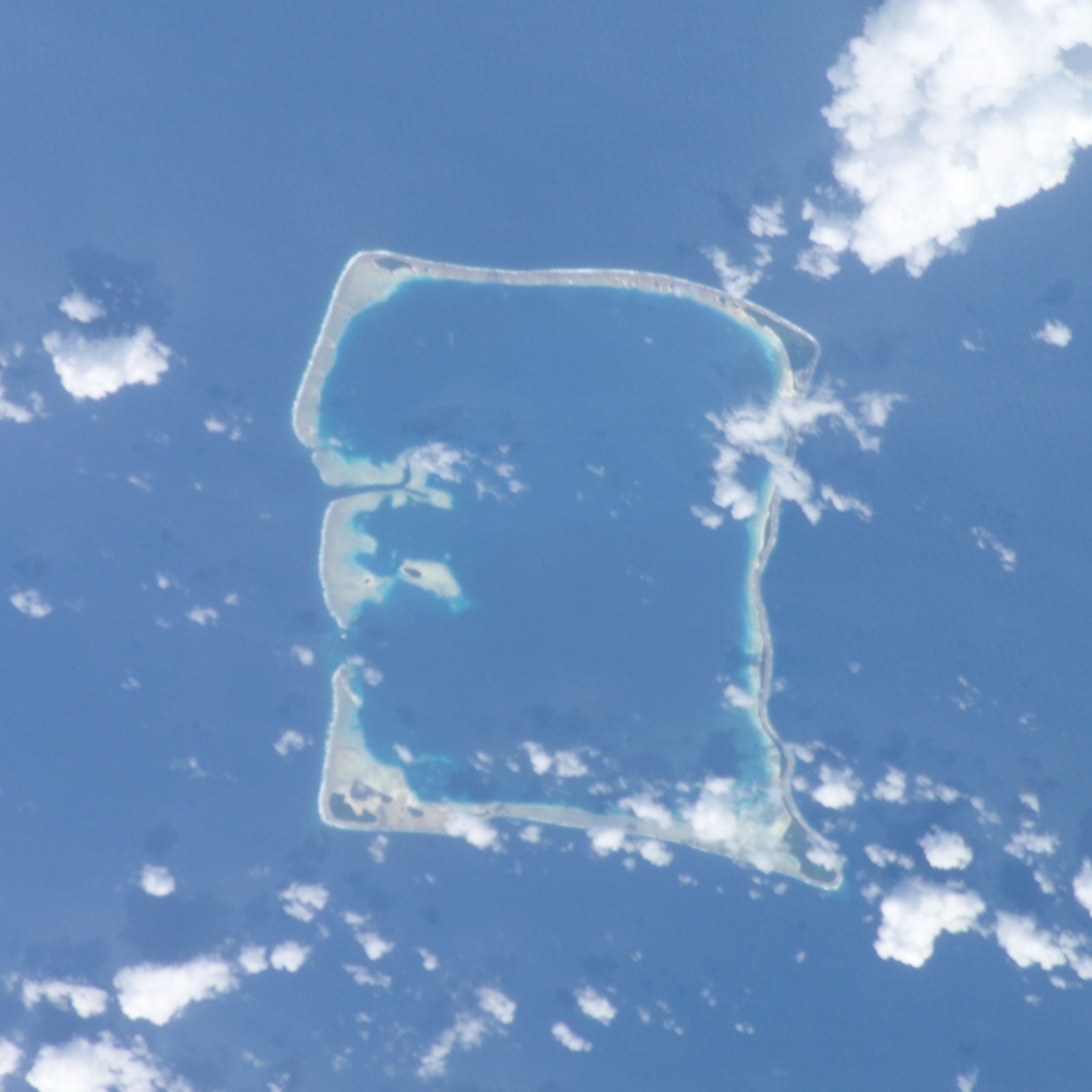 Nukufetau atoll from space | |
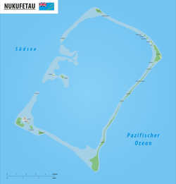 Map of the atoll | |
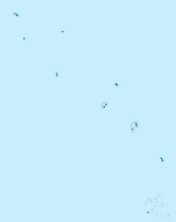 Nukufetau Location in Tuvalu | |
| Coordinates: 08°00′S 178°22′E | |
| Country | Tuvalu |
| Population (2017) | |
| • Total | 597 |
| ISO 3166 code | TV-NKF |
Geography
Nukufetau is an atoll with passages through the reef that allow large ships to enter and anchor in the lagoon. Nukufetau consists of at least 33 islets:
- Faiava Lasi
- Fale
- Funaota
- Kongo Loto Lafanga
- Lafanga
- Matanukulaelae
- Motufetau
- Motulalo
- Motuloa (north of Nukufetau)
- Motuloa (south of Nukufetau)
- Motumua
- Niualuka
- Niuatui
- Oua
- Sakalua
- Savave
- Teafatule
- Teafuaniua
- Teafuanonu
- Teafuone
- Temotuloto
- and at least 12 other islands
The biggest island is Motulalo. In the late 19th century, after the coming of the missionaries, the people of Nukufetau lived on Fale islet before shifting to Savave which is on the lagoon side of the Fale settlement.[4]: 86–87
On Savave islet 331 people live in Aulotu and 191 live in Maneapa (2012 census).[3]
History

The traditional history of Nukufetau is that a party of Tongans were the first people to settle. When they landed they found only one fetau (or fetaʻu in Tongan) tree growing on the atoll, so they called the place Nukufetau - the island of the fetau. They planted coconut trees and settled on Fale on the western side of the atoll.[4]: 86
Arent Schuyler de Peyster, of New York, captain of the armed brigantine or privateer Rebecca, sailing under British colours,[5][6] passed through the southern Tuvalu waters in May 1819 sighting Nukufetau.[7]
In 1820 the Russian explorer Mikhail Lazarev visited Nukufetau as commander of the Mirny.[7][8]
The United States Exploring Expedition under Charles Wilkes visited Nukufetau in 1841.[9]
Louis Becke, who later became a writer, operated a store on Nukufetau from February 1881 to August 1881.[10][11] Becke later wrote a story about a fishing expedition: The Fisher Folk Of Nukufetau.[12]
The population of Nukufetau from 1860 to 1900 is estimated to be 250 people.[13][14]
Alfred Restieaux was a trader on Nukufetau in the late 19th century from 1873 to 1879 and met his wife Litia.[15][16] He returned sometime in the 1880s; in 1892 Captain Davis, of HMS Royalist, recorded Alfred Restieaux and Emile Fenisot as trading on Nukufetau.[17] Restieaux died on Nukufetau in 1911.
Nukufetau Post Office opened around 1925.[18]
During World War II Coastwatchers, who observed and reported on Japanese shipping, had a station on Nukufetau.[19] In 1943 United States Navy Seabees build a deepwater wharf and an airfield on Motulalo, which is the largest islet of Nukufetau.[20] Two intersecting runways of Nukufetau Airfield formed an "X" shape.
B-24s were based at the airfield. The Marine Attack Squadron 331 (VMA-331) also flew Douglas SBD Dauntless dive bombers from Nukufetau.[21] After the war the airfield was dismantled and the land returned to its owners, however as the coral base was compacted to make the runway the land now provides poor ground for growing coconuts.[20]
Cyclone Pam, March 2015
Nukufetau was affected by storm surges caused by Cyclone Pam in early March 2015, which damaged houses, crops and infrastructure. As of 22 March, 76 people (13 percent of the population) were displaced and were living in 2 evacuation centres.[22] The Situation Report published on 30 March reported that on Nukufetau all the displaced people have returned to their homes. Nukufetau suffered the loss of 90% of crops.[23]
In 2016 a 500-metre seawall was constructed to improve the defences against severe wet weather events. The $8 million cost of the project was paid by the United Nations Development Programme and was carried out by dredging and civil contracting company Hall Pacific.[24][25]
General election, 2019
The 2019 general election was held on 9 September 2019. Enele Sopoaga was returned to parliament and Fatoga Talama was elected to represent Nukufetau in the parliament.[26]
| Party | Candidate | Votes | % | |
|---|---|---|---|---|
| Independent | Enele Sopoaga |
491 | 35.8 | |
| Independent | Afelee Falema Pita | 273 | 19.9 | |
| Independent | Valisi Alimau | 285 | 20.8 | |
| Independent | Fatoga Talama |
323 | 23.5 | |
Notable people
- Faimalaga Luka (April 15, 1940 – August 19, 2005) represented Nukufetau in the Parliament of Tuvalu. He served as Prime Minister (2001) and as Governor-General (2003-2005).[27]
- Saufatu Sopoanga, Prime Minister of Tuvalu (2002-2004), represented Nukufetau in the parliament for a number of years.[28][29]
- Enele Sopoaga, the younger brother of Saufatu Sopoanga, was elected to represent Nukufetau in the parliament in 2010, and served as the Prime Minister of Tuvalu from August 2013 until September 2019.
See also
 Tuvalu portal
References
- "Maps of Tuvalu". Retrieved 15 January 2021.
- British Admiralty Nautical Chart 766 Ellice Islands (1893 ed.). United Kingdom Hydrographic Office (UKHO). 21 March 1872.
- "Population of communities in Tuvalu". Thomas Brinkhoff. 2017. Retrieved 27 September 2020.
- Lafita, Nofoaiga (1983). "Chapter 12 - Nukufetau". In Laracy, Hugh (ed.). Tuvalu: A History. Institute of Pacific Studies, University of the South Pacific and Government of Tuvalu.
- De Peyster, J. Watts. Military (1776-'79) transactions of Major, afterwards Colonel, 8th or King's foot, Arent Schuyler de Peyster (with details of the discovery of the Ellice and de Peyster Islands in the Pacific Ocean, in May, 1819). Reproduction of original in: Bibliotheque nationale du Quebec. ISBN 0665040512.
- "The De Peysters".
- Kofe, Laumua (1983). "Chapter 15 - Palagi and Pastors". In Laracy, Hugh (ed.). Tuvalu: A History. Institute of Pacific Studies, University of the South Pacific and Government of Tuvalu. pp. 102–103.
- Keith S. Chambers & Doug Munro, The Mystery of Gran Cocal: European Discovery and Mis-Discovery in Tuvalu, 89(2) (1980) The Journal of the Polynesian Society, 167-198
- Tyler, David B. - 1968 The Wilkes Expedition. The First United States Exploring Expedition (1838-42). Philadelphia: American Philosophical Society
- A. Grove Day (1967). Louis Becke. Melbourne: Hill of Content. p. 35.
- 'Louis Beck, Adventurer and Writer', Chapter 8, Rascals in Paradise, James A. Michener and Arthur Grove Day, Secker and Warburg (1957)
- Becke, Louis. "The Fisher Folk Of Nukufetau". Retrieved 5 October 2013.
- W.F. Newton, The Early Population of the Ellice Islands, 76(2) (1967) The Journal of the Polynesian Society, 197-204.
- Richard Bedford, Barrie Macdonald & Doug Monro, Population Estimates for Kiribati and Tuvalu (1980) 89(1) Journal of the Polynesian Society 199
- Restieaux, Alfred. Recollections of a South Seas Trader – Reminiscences of Alfred Restieaux. National Library of New Zealand, MS 7022-2.
- Restieaux, Alfred. Reminiscences - Alfred Restieaux Part 2 (Pacific Islands). National Library of New Zealand, MS-Papers-0061-079A.
- The proceedings of H.M.S. "Royalist", Captain E.H.M. Davis, R.N., May-August, 1892, in the Gilbert, Ellice and Marshall Islands.
- Premier Postal History. "Post Office List". Premier Postal Auctions. Retrieved 5 July 2013.
- Clayworth, Peter (16 November 2012). "Coast-watching headquarters at Nukufetau, Ellice Islands, 1941". 'Intelligence services - Intelligence services, 1800s to 1945', Te Ara - the Encyclopedia of New Zealand. Retrieved 12 October 2013.
- Telavi, Melei (1983). "Chapter 18 - War". In Laracy, Hugh (ed.). Tuvalu: A History. Institute of Pacific Studies, University of the South Pacific and Government of Tuvalu. p. 143.
- Bartsch, Bill. "War Relics in Tuvalu and Kiribati" (PDF). South Pacific Bulletin (1975). Retrieved 7 April 2014.
- "Tuvalu: Tropical Cyclone Pam Situation Report No. 1 (as of 22 March 2015)". Relief Web. 22 March 2015. Retrieved 25 March 2015.
- "Tuvalu: Tropical Cyclone Pam Situation Report No. 2 (as of 30 March 2015)". Relief Web. 30 March 2015. Retrieved 30 March 2015.
- "Work underway on stronger seawall in Tuvalu". RNZ. 2016-08-25. Retrieved 2020-05-08.
- "Construction Commences on Nukufetau Seawall". Hall Contracting. Retrieved 2020-05-08.
- Tahana, Jamie (10 September 2019). "Tuvalu elections: large turnover for new parliament". Radio New Zealand. Retrieved 10 September 2019.
- Lansford, Tom (2015). Political Handbook of the World 2015. CQ Press.
- "Palamene o Tuvalu (Parliament of Tuvalu)". Inter-Parliamentary Union. 2002. Retrieved 7 March 2013.
- "Palamene o Tuvalu (Parliament of Tuvalu)". Inter-Parliamentary Union. 2006. Retrieved 7 March 2013.
| Islands |  | |
|---|---|---|
| Atolls | ||
| Islets of Funafuti | ||
| Islets of Nanumea | ||
| Islets of Nui | ||
| Islets of Nukufetau | ||
| Islets of Vaitupu | ||
Authority control | |
|---|---|
| General |
|
| National libraries | |
| Other |
|
На других языках
[de] Nukufetau
Nukufetau (historisch De Peyster Islands) ist ein Atoll des pazifischen Inselstaats Tuvalu. Es liegt rund 57 Kilometer südwestlich von Vaitupu.- [en] Nukufetau
[es] Nukufetau
Nukufetau es uno de los nueve atolones de Tuvalu,[1] ubicado a 86 km al nordeste de Funafuti y a 57 km al sudoeste de Vaitupu. Su superficie total es de 2,99 km². La isla fue reclamada por los Estados Unidos en los años de 1800s y fue cedida en un Tratado de Amistad finalizada en 1979 y forzando su retorno en 1983. Según el censo en el 2002, tiene una población de 586 habitantes y posee 35 islas:[fr] Nukufetau
Nukufetau est un atoll des Tuvalu, un État-archipel d'Océanie.[ru] Нукуфетау
Нукуфетау (англ. Nukufetau) — атолл в центральной части архипелага Тувалу в 86 км к северо-западу от Фунафути и в 57 км к юго-западу от Ваитупу. Административно-территориальная единица (островной совет) государства Тувалу.Другой контент может иметь иную лицензию. Перед использованием материалов сайта WikiSort.org внимательно изучите правила лицензирования конкретных элементов наполнения сайта.
WikiSort.org - проект по пересортировке и дополнению контента Википедии