geo.wikisort.org - Island
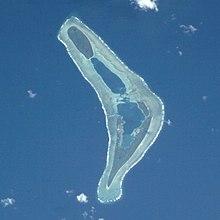
Te Motu Foliki is an islet of Nanumea atoll, Tuvalu.[1][2] It is a small uninhabited islet, which Nanumean traditions describe as being formed when sand spilled from the baskets of two women, Pai and Vau, when they were forced off Nanumea by Tefolaha, the Tongan warrior who became the ancestor of the people of Nanumea.[3]

See also
- Desert island
- List of islands
References
- Map of Nanumea. Tuvaluislands.com.
- British Admiralty Nautical Chart 766 Ellice Islands (1893 ed.). United Kingdom Hydrographic Office (UKHO). 21 March 1872.
- Isako, Taulu (1983). "Chapter 7 – Nanumea". In Laracy, Hugh (ed.). Tuvalu: A History. Institute of Pacific Studies, University of the South Pacific and Government of Tuvalu. p. 49.
На других языках
[de] Temotufoliki
Temotufoliki ist die drittgrößte Insel des Nanumea-Atolls im südpazifischen Inselstaat Tuvalu. Sie liegt im Osten des Atolls, nur 30 Meter nördlich des östlichen Arms der Hauptinsel Nanumea und grenzt an die südliche Lagune. Die Insel ist 24 Hektar groß.- [en] Temotufoliki
[it] Temotufoliki
Temotufoliki è la terza isola più grande dell'atollo di Nanumea, a Tuvalu, uno stato insulare del Pacifico meridionale. Si trova nella parte orientale dell'atollo, a soli 30 metri a nord del braccio orientale dell'isola principale di Nanumea, e si affaccia sulla laguna meridionale. Copre una superficie di 24 ettari.Текст в блоке "Читать" взят с сайта "Википедия" и доступен по лицензии Creative Commons Attribution-ShareAlike; в отдельных случаях могут действовать дополнительные условия.
Другой контент может иметь иную лицензию. Перед использованием материалов сайта WikiSort.org внимательно изучите правила лицензирования конкретных элементов наполнения сайта.
Другой контент может иметь иную лицензию. Перед использованием материалов сайта WikiSort.org внимательно изучите правила лицензирования конкретных элементов наполнения сайта.
2019-2025
WikiSort.org - проект по пересортировке и дополнению контента Википедии
WikiSort.org - проект по пересортировке и дополнению контента Википедии
