geo.wikisort.org - Island
Nanumanga or Nanumaga is a reef island and a district of the Oceanian island nation of Tuvalu.[1][2] It has a surface area of about 3 km² with a population of 491 (2017 Census).[3]
Nanumanga | |
|---|---|
Reef Island | |
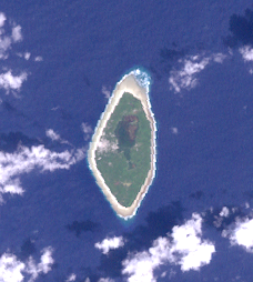 NASA Landsat visible color image | |
 Map of the island | |
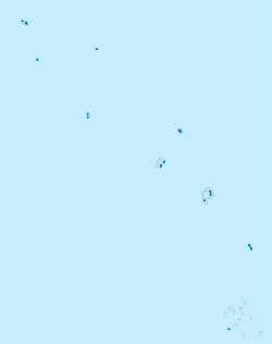 Nanumanga Location in Tuvalu | |
| Coordinates: 06°17′15″S 176°19′15″E | |
| Country | Tuvalu |
| Area | |
| • Total | 3 km2 (1 sq mi) |
| Population (2017) | |
| • Total | 491 |
| • Density | 160/km2 (420/sq mi) |
| Demonym | Nanumangan |
| ISO 3166 code | TV-NMG |
History
On 9 May 1824 a French government expedition under Captain Louis Isidore Duperrey of the ship La Coquille sighted Nanumaga.[4][5]
The US Exploring Expedition visited in 1841.[6]
Louis Becke, who later became a writer, became the resident trader for the Liverpool firm of John S. de Wolf and Co. on Nanumaga from about April 1880 until the trading-station was destroyed later that year in a cyclone.[7][8] Becke later wrote The Rangers of the Tia Kau[9] that describes a shark attack at the Tia Kau reef between Nanumea and Nanumaga.
The population of Nanumaga from 1860–1900 is estimated to be between 300[10] to 335 people.[11]
Nanumaga Post Office opened around 1925.[12]
In 1986 it became a centre of debate when Pacific archaeologists discovered the submerged Caves of Nanumanga, and found what they argued was the remains of fire created by pre-historic inhabitants.
Geography
The Nanumaga landscape consists of the main village settlements of Tonga and Tokelau, the two main pits for swamp taro (Cyrtosperma merkusii), (known in Tuvalu as Pulaka), the mangrove forest surrounding the internal lagoons and the areas of general vegetation which includes coconuts, pandanus trees and other vegetation types.[13]
The island has an oval outline, with the longer axis oriented north-south. A fringing reef surrounds the whole island, which makes local fishing and transport into and out of the island difficult.[14]
There are two brackish-water lagoons, the largest, Vaiatoa, having four islands. Vaiatoa Lagoon is located in the north of the island while the smaller Ha’apai Lagoon is in the south. A causeway has been construct to the south of Vaiatoa Lagoon linking the village areas of Tonga and Matematefaga.[15]
There are mangrove trees, native broadleaf forest and coconut palms. The two recorded mangrove species in Tuvalu are the common Togo (Rhizophora stylosa) and the red-flowered mangrove Sagale (Lumnitzera littorea). The mangrove forest of the northern Vaiatoa lagoon covers an area approximately 20 hectares.[16]
Nanumaga has a Locally Managed Marine Area, which encompasses the entire island. No fishing is allowed on the reef on the western side of the island, except handlining. Spear fishing is also totally banned on the island.[17] A sea mount located just off the northern tip of the island is an important key fishing ground, which has been declared a ‘no anchor zone’.[17]
In March 2015 Nanumaga suffered damage to houses, crops and infrastructure as the result of storm surges caused by Cyclone Pam; 60-100 houses were flooded and the health facility suffered damage.[18][19]
Capes
- Cape on the north: Te Kaupapa
- Cape on the south: Te Papa
Villages
At the 2012 census the population of the villages was:[3]
- Tokelau with 245 people;
- Tonga, also spelled Toga with 236 people.
The junior school is Lotohoni Primary School.
Transportation
There are a few paths and unpaved roads. There are no airports, so everything goes in and out by boat. There is an unprotected 10m wide boat channel that cuts into the fringing reef. The boat landing is where passengers and cargo is landed from the inter-island ferry workboats.[20]
Politics
Nanumanga is one of the eight constituencies in Tuvalu, and elects two Members of Parliament. Following the 2019 general election, Monise Lafai was returned to parliament and Minute Alapati Taupo was elected to parliament.[21]
| Party | Candidate | Votes | % | |
|---|---|---|---|---|
| Independent | Monise Lafai |
366 | 36.2 | |
| Independent | Otinielu Tausi | 284 | 28 | |
| Independent | Minute Alapati Taupo |
361 | 35.7 | |
Climate Crisis
In 2016 the Tuvalu National Council for Women worked with the Green Climate Fund to enable women from the islands of Nanumea and Nanumaga to be part of talks about climate crisis. One of their key issues was the additional burden of social care that women take on in the aftermath of natural disasters.[22]
Notable local people
Otinielu Tausi was the deputy prime minister in the government of Kamuta Latasi (December 1993 to December 1996); Deputy Prime Minister and Minister for Natural Resources and also the Home Affairs and Rural Development in the 2nd government of Bikenibeu Paeniu (1996 to 1998). He served as the speaker of the Parliament of Tuvalu from 2003 until 2006, then again from March 2014 until he was not re-elected to parliament in the general election held on 9 September 2019.
Tuau Lapua Lapua is a Tuvaluan Olympic weightlifter. At the 2013 Pacific Mini Games, Tuau Lapua Lapua won Tuvalu's first ever gold medal in major sporting competition in the men's 62 kilogram snatch. (He also won bronze in the clean and jerk, and obtained the silver medal overall for the combined event.)
References
- "Maps of Tuvalu". Retrieved 15 January 2021.
- British Admiralty Nautical Chart 766 Ellice Islands (1893 ed.). United Kingdom Hydrographic Office (UKHO). 21 March 1872.
- "Population of communities in Tuvalu". Thomas Brinkhoff. 2017. Retrieved 27 September 2020.
- Doug Munro and Keith S. Chambers (1989). "Duperrey and the Discovery of Nanumaga in 1824: an episode in Pacific exploration". Great Circle. 11: 37–43.
- Doug Munro and Keith S. Chambers (1980). "The Mystery of Gran Cocal: European Discovery and Mis-Discovery in Tuvalu". Journal of the Pacific Society. 89 (2): 167–198.
- Stanton, William (1975). The Great United States Exploring Expedition. Berkeley: University of California Press. pp. 240. ISBN 0520025571.
- A. Grove Day (1967). Louis Becke. Melbourne: Hill of Content. pp. 30–34.
- 'Louis Beck, Adventurer and Writer', Chapter 8, Rascals in Paradise, James A. Michener and Arthur Grove Day, Secker and Warburg (1957)
- "The Rangers of Tia Kau". By Reef and Palm by Louis Becke. 1893. Retrieved 6 April 2021.
- Richard Bedford, Barrie Macdonald & Doug Monro, Population Estimates for Kiribati and Tuvalu (1980) 89(1) Journal of the Polynesian Society 199
- W.F. Newton, The Early Population of the Ellice Islands, 76(2) (1967) The Journal of the Polynesian Society, 197–204.
- Premier Postal History. "Post Office List". Premier Postal Auctions. Retrieved 5 July 2013.
- FCG ANZDEC Ltd (7 August 2020). Tuvalu Coastal Adaptation Project: Environmental and Social Impact Assessment - Nanumaga and Nanumea (Report). The Pacific Community. pp. 64 & 78. Retrieved 6 February 2021.
- "Life on Nanomanga". V(2) Pacific Islands Monthly. 21 September 1934. Retrieved 27 September 2021.
- FCG ANZDEC Ltd (7 August 2020). Tuvalu Coastal Adaptation Project: Environmental and Social Impact Assessment - Nanumaga and Nanumea (Report). The Pacific Community. pp. 45 & 66. Retrieved 6 February 2021.
- FCG ANZDEC Ltd (7 August 2020). Tuvalu Coastal Adaptation Project: Environmental and Social Impact Assessment - Nanumaga and Nanumea (Report). The Pacific Community. p. 66. Retrieved 6 February 2021.
- FCG ANZDEC Ltd (7 August 2020). Tuvalu Coastal Adaptation Project: Environmental and Social Impact Assessment - Nanumaga and Nanumea (Report). The Pacific Community. p. 73. Retrieved 6 February 2021.
- "Tuvalu: Tropical Cyclone Pam Situation Report No. 2 (as of 30 March 2015)". Relief Web. 30 March 2015. Retrieved 30 March 2015.
- "Tuvalu situation update: Securing health from disastrous impacts of cyclone Pam in Tuvalu". Relief Web/World Health Organization – Western Pacific Region. 3 April 2015. Retrieved 8 June 2015.
- FCG ANZDEC Ltd (7 August 2020). Tuvalu Coastal Adaptation Project: Environmental and Social Impact Assessment - Nanumaga and Nanumea (Report). The Pacific Community. p. 91. Retrieved 6 February 2021.
- Tahana, Jamie (10 September 2019). "Tuvalu elections: large turnover for new parliament". Radio New Zealand. Retrieved 10 September 2019.
- FP015: Tuvalu Coastal Adaptation Project (PDF). Green Climate Fund.
| Islands |  | |
|---|---|---|
| Atolls | ||
| Islets of Funafuti | ||
| Islets of Nanumea | ||
| Islets of Nui | ||
| Islets of Nukufetau | ||
| Islets of Vaitupu | ||
Authority control | |
|---|---|
| General |
|
| National libraries | |
На других языках
[de] Nanumanga
Nanumanga (auch Nanumaga) ist eine Insel des Pazifikstaates Tuvalu und einer der acht Bezirke des Landes.[1] Hauptort ist Tokelau. Die Insel hat 481 Einwohner (Stand 2012)[2] in zwei Dörfern. Historisch war die Insel in drei Bezirke unterteilt: Tonga, Tokelau und Lemuli. Davon sind nur noch Toga (ehemals Tonga; 236 Einwohner) und Tokelau (245 Einwohner) bewohnt. Beide Dörfer liegen in unmittelbarer Nachbarschaft an der Westküste; Tokelau liegt nördlich von Tonga. Die Insel ist 2,78 Quadratkilometer groß.- [en] Nanumanga
[es] Nanumanga
Nanumaga o Nanumanga es una isla, un atolón o un distrito de Tuvalu. Tiene un área aproximada de 3 km². Durante el año 1986 se convirtió en centro de debate entre los arqueólogos del Pacífico, quienes descubrieron las Cuevas sumergidas de Nanumanga, en las cuales encontraron presencia de fuego creado por habitantes pre históricos. Su economía está basada en el turismo su fauna salvaje es una gran atracción para el turismo. Aunque su vegetación es seca, su fauna es extensa y como ya se dijo el turismo es su mayor recurso para su economía.[fr] Nanumaga
Nanumaga, anciennement orthographié Nanumanga, est une île corallienne des Tuvalu, un État-archipel d'Océanie.[ru] Нануманга
Нануманга (англ. Nanumanga) — атолл и административно-территориальная единица (островной совет) государства Тувалу.Другой контент может иметь иную лицензию. Перед использованием материалов сайта WikiSort.org внимательно изучите правила лицензирования конкретных элементов наполнения сайта.
WikiSort.org - проект по пересортировке и дополнению контента Википедии