geo.wikisort.org - Island
Niulakita is the southernmost island of Tuvalu,[1] and also the name of the only village on this island. Niulakita has a population of 34 (2017 Census).[2] The residents of Niulakita have moved to the island from Niutao. Niulakita is represented in the Parliament of Tuvalu by the members of the constituency of Niutao.
Niulakita | |
|---|---|
Reef Island | |
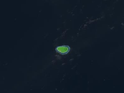 Satellite picture | |
 Map of the island | |
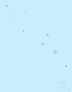 Niulakita Location in Tuvalu | |
| Coordinates: 10°47′21″S 179°28′23″E | |
| Country | Tuvalu |
| Area | |
| • Total | 0.40 km2 (0.15 sq mi) |
| Elevation | 4.6 m (15.1 ft) |
| Population (2017) | |
| • Total | 34 |
| • Density | 85/km2 (220/sq mi) |
Geographical features
Niulakita is a reef island.[3] There are four ponds or lakes and the village has a maneapa (a community hall) in Tuvalu, which provides meeting and recreational functions as well. The isle has an oval outline, with the longer axis running east–west (about 1 km long). This island features highest point of Tuvalu (4.6 metres (15 ft) above sea level). A fringing reef surrounds the whole island, which makes local fishing and transport into and out of the island difficult.
Historical background
The discovery of Niulakita is claimed by travellers from Nui, led by Kaunatu who was taking people home to Vaitupu, however their canoe drifted off course to the south and they arrived at Niulakita. There was only saltbrush (Atriplex) and pukavai trees (Pisonia grandis) on the islands. Kaeula, one of the passengers, died and was buried with the last of their coconuts planted at the head of his grave. The island was named by Kaunatu after a place of that name on Nui.[4]
The first sighting recorded by Europeans of Niulakita was on 29 August 1595 by the Spanish navigator Alvaro de Mendaña during his second expedition encountered Niulakita. The island was charted as La Solitaria (Lonesome in Spanish).[5][6][7] An attempt was made to find a port with two small vessels in its southern part but the bottom was uneven and rocky and they abandoned their attempts.[8]
In 1821 Captain George Barrett, of the Nantucket whaler Independence II, visited Niulakita, which he named Rocky (Group).[6] This name was never much used, but Independence Island, after Barrett's ship, was one of the several names which came into general use for Niulakita during the 19th century. Niulakita was also known as Sophia.[6]
In about 1879 the elders of Vaitupu were interested in Niulakita and send a working party to plant coconuts on the island.[9] However, in 1880 they were informed that J. C. Godeffroy und Sohn of Hamburg (operating out of Samoa) claimed ownership of the island.[9] Notwithstanding this claim in 1884 the Vaitupu elders transferred their claim to Niulakita to H. M. Ruge and Company, a German trading firm that operated from Apia, for $400 in part payment of a debt of $13,000 to Ruge & Co.[10] Ruge & Co became insolvent in about 1888. On 15 April 1889 Niulakita was sold for $1,000 to Mr H. J. Moors, an American citizen living in Apia, Samoa.[9] On 16 September 1896 Captain Gibson R.N., of HMS Curacoa, recorded in his journal that six men and six women, natives of various islands, were living on Niulakita working for Moors. Captain Gibson determined that the island was not under American protection so he hoisted the Union Jack and delivered the flag, with a copy of the Declaration of British Protectorate, to the headman of the working party.[9][11]
In August 1896, the sailing ship Seladon of Stavanger was wrecked on the coral reef of Starbuck Island. The crew of 16 men were in the lifeboats with little food and water for 30 days, until they arrived at Niulakita. The crew were stranded for ten months until rescued by a passing steam ship.[12]
It was bought by the Gilbert and Ellice Islands Colony administration in 1944. The administration gave people from Vaitupu permission to settle Niulakita. However, in 1949 a later administration decided to have Niulakita settled by the community from Niutao, which was considered to be overpopulated. The removal of the Vaitupuans was controversial.[13]
The United States asserted a claim to Niulakita under the Guano Islands Act of 1856; this claim was renounced under the 1983 treaty of friendship between Tuvalu and the United States.[14]
Education
Niulakita's junior school is Lotoalofa Primary School.
See also
- Geography of Tuvalu
- Samoa hotspot
- List of Guano Island claims
References
- "Maps of Tuvalu". Retrieved 15 January 2021.
- "Population of communities in Tuvalu". Thomas Brinkhoff. 2017. Retrieved 27 September 2020.
- British Admiralty Nautical Chart 766 Ellice Islands (1893 ed.). United Kingdom Hydrographic Office (UKHO). 21 March 1872.
- Pape, Sotaga (1983). "Chapter 10 – Nui". In Laracy, Hugh (ed.). Tuvalu: A History. Institute of Pacific Studies, University of the South Pacific and Government of Tuvalu. p. 77.
- Maude, Islands and Men: Studies in Pacific History, Melbourne: Oxford University Press (1986) p.307
- Keith S. Chambers & Doug Munro, The Mystery of Gran Cocal: European Discovery and Mis-Discovery in Tuvalu, 89(2) (1980) The Journal of the Polynesian Society, 167–198
- Laumua Kofe, Palagi and Pastors, Tuvalu: A History, Ch. 15, (U.S.P./Tuvalu)
- Maude, H.E. Spanish discoveries in the Central Pacific. A study in identification Journal of the Polynesian Society, Wellington, LXVIII, 1959, pp.306,307.
- Roberts, R.G. (1958). Te Atu Tuvalu: A short history of the Ellice Islands. 67 (4) Journal of the Polynesian Society. pp. 196–197.
- Laupepa, Kalaaki (1983). "Chapter 11 – Vaitupu". In Laracy, Hugh (ed.). Tuvalu: A History. Institute of Pacific Studies, University of the South Pacific and Government of Tuvalu. p. 78.
- Laracy, Hugh, ed. (1983). "The 'Ownership' of Niulakita, 1880–1896". Tuvalu: A History. Institute of Pacific Studies, University of the South Pacific and Government of Tuvalu. pp. 196–197.
- Wincent Rege, Malvin Rege & Eli Rege (2012). The wreck of the Seladon: A true survival on an island story. CreateSpace. ISBN 978-1470002459.
- "Foua Tofiga". tighar.org. Archived from the original on 2 February 2017. Retrieved 26 April 2015.
- "DOI Office of Insular Affairs (OIA) – FORMERLY DISPUTED ISLANDS". Doi.gov. Archived from the original on 30 September 2007. Retrieved 15 September 2009.
External links
| Islands |  | |
|---|---|---|
| Atolls | ||
| Islets of Funafuti | ||
| Islets of Nanumea | ||
| Islets of Nui | ||
| Islets of Nukufetau | ||
| Islets of Vaitupu | ||
Authority control | |
|---|---|
| General |
|
| National libraries | |
На других языках
[de] Niulakita
Niulakita ist die südlichste Insel Tuvalus. Zusammen mit Niutao bildet Niulakita einen der acht Bezirke des Inselstaates, den Bezirk Niutao.[1] Das einzige Dorf auf der Insel ist das gleichnamige Niulakita an der Südwestküste. Die Insel hat 27 Einwohner (Stand 2012).[2] Alle Einwohner wanderten von der überbevölkerten Insel Niutao seit 1949 zu.- [en] Niulakita
[es] Niulakita
Niulakita es una de las nueve islas que componen Tuvalu y la que se ubica más al sur del país insular. Fue comprada por el Reino Unido a mitad del siglo XX, época en la cual decayó la población. Tiene una población de 27 habitantes, según un censo realizado en 2012. Es la isla habitada más pequeña y que se encuentra a 270 kilómetros de Funafuti, la capital del país.[fr] Niulakita
Niulakita est une île des Tuvalu, un État-archipel d'Océanie.[ru] Ниулакита
Ниулакита (англ. Niulakita) — самый южный остров архипелага Тувалу, расположенный в 270 км к югу от Фунафути, столицы Тувалу.Другой контент может иметь иную лицензию. Перед использованием материалов сайта WikiSort.org внимательно изучите правила лицензирования конкретных элементов наполнения сайта.
WikiSort.org - проект по пересортировке и дополнению контента Википедии